3.5 km. Enough sitting around hoping those final few kilometers will climb themselves. Wait too long and the summer heat and humidity will be formidable foes. Climb now and risk a sudden change in the weather. I opt for a coin toss – heads and I go this weekend; tails and I put it off another week. Heads.
I set the alarm for 6am but wake up naturally at 5:30 as daylight filters through the curtains and the cacophony of birdsong force me from my slumber. The rucksack sits tiny in the corner of my office while I double-check the battery in my camera – I am not making that mistake again. The 7:05am train whisks me into downtown Osaka, where the subway deposits me directly in the center of Namba for the long train journey to Kawachi-Nagano. With a bit of time to kill before the first bus to Takihata dam I explore the backstreets and discover the remnants of an ancient inn along the Koya-Kaido, or old road to Koyasan. A gargantuan Kusunoki (Japanese camphor) tree occupies the better part of the hidden garden at the back of the inn. Awestruck I stand, gazing at the massive branches soaring toward the stratosphere. The honk of an annoyed motorist jars me back to reality – I guess the locals aren’t accustomed to tourists blocking the road to gaze up a slice of the forgotten past.

The bus ride involves mountain talk with a trio of young hikers who are planning an ascent of Iwawaki. I warn them about the mamushi who tried to take me out back in April as Murakami-san sends some important intel my way about Mt Makio, my destination for the day. “It’s easy to get lost up there as there are a multitude of tracks”, offers my newfound companion. We exchange contact information upon alighting and I head across the rickety steel suspension bridge for my last hurrah with the Diamond trail.

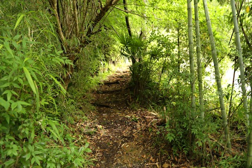
The signposts guide me to the end of a cul-de-sac and around a farmer’s garden to a narrow track still flowing with fresh rainwater from the previous day’s torrential rain. Greenery immediately engulfs me as I head through a lush canopy of rich foliage. With the rainy season having commenced early this year, the forests are thriving with undergrowth and buzzing with six-legged life. An initial steep climb through a well-worn channel of eroded spur soon gives way to a flat traverse along the steep contours. The stillness of the air sends the sweat glands into full production as a hornet does a quick fly-by before deciding that my stinky body is not worthy of investment.

The track skirts the edge of a washed out escarpment affording views across the valley over to Mt Iwawaki, which looks formidably far from reach. I silently praise myself for having the foresight to cut my hike of Section 5 short at Takihata instead of trying to push it to the end. The soothing aromas of the wet ferns and moss provide an olfactory buzz, as well as a reminder that the mountain slopes are tightly gripped in the claws of the wet season. I edge my way along the narrow path, across the narrow wooden planks spanning older, washed out sections of trail.

Monocultural columns of cedar yield to a verdant labyrinth of hardwoods which guide me to Bote-tōge at roughly the halfway point in the climb. I pause here on a wooden bench to catch my breath and shed a layer. A duo of elderly hikers sit perched nearby, offering informative replies to my anxious inquiries. “You shouldn’t miss the carvings in the main sanctuary”, replies the bespectacled hiker sitting on an adjacent bench. Armed with this extra intel I drop down the opposite valley through yet more fascinating remnants of old growth past. The rich greens of the Mongolian oak canopy glisten in the late morning light seeping through the cloud cover overhead. The bulbous form of Mt Makio rises majestically on the horizon as the track drops toward another secluded valley. Stone jizō statues adorned with Sanskrit adorn the route as a nod to Makio’s Buddhist roots.

Hugging the edge of a gully, the trail descends to a small waterfall in an unnamed watershed and rises up the opposite slop to Banya-tōge. Judging by the name, there must have been some kind of watch tower erected here during the feudal times, perhaps to keep tabs on the movement of pilgrims along this well-traveled route. A head-high barbed wire fence blocks entry down the northeastern slopes, such overdone barriers a common site for paranoid landowners who want to keep unwanted mountain riff raft from encroaching on their hidden caches. Oddly enough, this fence looks recently erected, so perhaps a rogue Diamond Trail rambler recently caused a riotous ruckus, but it could just be the debilitating humidity that conjure up such thoughts.

Another drop down to the northwest brings me to Oiwake junction. Here, the trail crosses a forest road that leads to Takihata dam, an alternative approach for those hikers who adore walking on rugged concrete roads. A signpost indicates that I have just 1000 horizontal meters separating me from the end of the Diamond trail, so I cross over a narrow wooden bridge spanning a gentle brook and climb past the first of many stone building foundations. Sefukuji temple, built in the 6th century, was once a vast temple complex hosting around a thousand monks in training, including Kukai himself. Though is there really any part of Japan that Kōbō Daishi has not marked with his magic touch?

I weave up and around these stone foundation ruins and reach a junction on my left for the summit of Mt Makio. Ignoring this track, I veer left past a collection creeping saxifrage clinging tightly to the top of a low rock wall. My path steepens past a pair of dilapidated structures until reaching the entrance to the main sanctuary of Sefukuji. A nondescript stone marker sits on the ground at the trail junction, identical to the one I had encountered at Donzurubō. The kanji characters for 起点 or kiten flank the righthand side of the marker, informing me that I have indeed reached the end of the Diamond Trail. I breathe a sigh of relief for accomplishing my goal but come to the realization that I am literally in the middle of nowhere. What kind of trail ends on a mountaintop?

A handful of other visitors mill about the modest grounds of the temple. Most are dressed in cotton shirts and sneakers and have taken the easy way up by starting from the parking lot a 20-minute walk downhill on a concrete road. Before paying my respects to the deities, I make an offering to the lords of the privy. Just opposite the restroom sits a small lookout point that affords a vista back across the valley to Mt Iwawaki and further east towards Mt Kongō. I consider pausing here for a rest but decide to pay my respects first. “That’ll be 500 yen” barks the rambunctious temple caretaker, a lady in her mid-60s that exudes that Kansai freewheeling spirit. “Take all the photos you like”, she beams, pointing to the placard indicating that the 500 yen entitles visitors to all the snapshots they wish to take, in perhaps the only temple in Japan that openly embraces technology. “Instagram, Twitter, share anything and everything”, explains my guide. She clearly went to the Osaka school of propriety.

I step up into the sanctuary, turn left, and immediately drop to my knees, gobsmacked by the sheer beauty of central figure of Miroku Bosatsu towering over me. I offer a prayer before raising my lens for the social media masses.

The temple was razed by Nobunaga in the 16th century and burned down a second time near the end of the Edo era, but the statues on display in this main hall were salvaged from the fire and sit here undisturbed. I sit in complete silence, frozen by my inner voice which simply says, “stay”. I enter a trance and let my thoughts wander before exploring the rest of the main hall. I continue clockwise and find the Kannon statue that qualifies for Sefukuji’s inclusion on the venerable list of the 33 temples of the Saigoku Kannon Pilgrimage.

In back of the main statue sits a wooden carving of Kōbō Daishi flanked on all sides by a plethora of centuries-old wood carvings of Buddhist dieties. Many of these ancient sculpture still retain hints of color. Opposite Kukai’s statue, a reclining Buddha reposes peacefully. Forget the temples of Kyoto. If you really want to awe visitors, bring them to Sefukuji.

Hunger pangs remind me that sustenance is in order, so I begrudgingly retreat from the sanctuary, thank the caretaker, and descend back to the junction for the summit of Mt Makio. The track traverses below the summit before arriving at a narrow ridge. I turn right and follow the contours to the nondescript summit of Mt Makio. An echo of voices below pull me in – a rock formation below the high point purportedly affords mesmerizing views but my maps tell me that the rock formation is off limits to hikers. Still, I push on and find a fellow group of elderly rule breakers and join them on the intrusion. I settle down on the massive boulder and tuck into my lunch.

A couple approaches from the opposite end of the boulder as I quiz them on trail conditions. You see, this trail is also off limits to hikers but they inform me that the path is well-traveled and easy to follow. I check the map and decide to descend directly down to the shuttle bus stop. It is now 12:30, and the next bus is scheduled to depart at one o’clock. I tuck the camera away and settle into a frantic pace that has earned me the nickname of Max Descent from more than one hiker.

I arrive at the bus stop at 12:59 and collapse into an empty seat. Mt Makio not only doubles as the start/finish of the Diamond trail, but it is also the northernmost peak in the Izumi mountains, a full traverse of which has been on my mind for a while. I have already done the southern half of the range, so just 33 kilometers separate myself from a luxurious finish at Inunakiyama hot spring. I vow to return, under the cooler veil of winter when I can enjoy these peaks in better comfort.

All in all, the Diamond Trail is a roundabout way to transfer from the Kintestu-Minami Osaka line to the Nankai Main line, though certainly not the fastest way to change between the two divergent train networks. Now that I have complete the 45-km “long trail”, the million dollar question is: would I recommend it? I think you can find the answer to that inquiry in part 5 of the saga.
