Kanako couldn’t understand why I wanted to return to the very mountain that almost took my life, but Ted and I needed answers. This time we were equipped with two things that we didn’t possess the first time around: a good map and a GPS device.
We arrived back at Hata village around 10:30am on a quiet Friday in late March, hoping that most of the snow would be gone. We were joined this time by Ted’s wife Miki and another friend named Dominic, who had planned to summit the peak and tagged along for the first part of the traverse. The best course of action, we agreed, was to ascend via the Yokotani route that we had descended on our fateful night in January. From there, we’d head along the ridge, trying to fit together the missing pieces of the puzzle.

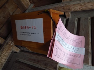
At the bus stop, Ted and I noticed something that was not there when we climbed in January: a wooden box for hikers to register their hiking plans. Pink pieces of paper were tied to the box with string. In addition, there was also a new, full-color laminated poster telling hikers the importance of registering their hike. Well, at least some good came out of our plight, but I really wonder how often the authorities check those boxes. I half-considered writing our intentions on here, along with a personal message to the cops that interrogated us, but I restrained myself.

The route, although unmarked in the village, was easy to find. It looked much different when not covered by 30cm of snow though. Once we crossed the forest road, Ted and I found the watershed that we somehow climbed down in the dark. The path ran pretty much parallel to the creek for the first part of the climb before leaving the gully and rising via some wavy switchbacks to the ridge. Ted and I pretty much pinpointed the place where we had finally found the real trail and could descend back to the village. The gully looked much steeper than I remember: mountains always look bigger when peering up from below than vice versa.
All of us reached the junction on the ridge somewhere around 11:15am. 90% of the snow was completely melted, sans the shaded folds of the gullies on the northern face. The next step was to march along the ridge, stopping to observe every concrete survey marker until we found the magic #74, where we hoped to find the remnants of our failed fire. We strolled along the ridge for about 10 minutes until things started to look familiar: blue bands of tape wrapped around the cedar trees, as well as a long flat expanse along the ridge where we searched aimlessly for the direction of the trail. Finally, we found the magic spot. Survey marker #75~! Oops – so we had been one number off, but what do you expect when you’re fighting for survival. Amongst the kindling were pieces of my shredded guidebook, a Snickers wrapper, and a handful of Ted’s discarded stormproof matches that had failed us that night. In hindsight, it was a good thing we couldn’t get that fire started, as we likely would have frozen to death perched up on this 700-meter peak without proper shelter.

As I surveyed the surroundings, I was shocked to find a metal signpost attached to a tree no more than 10 meters from where we called for help. It was a helicopter rescue point, giving a pinpointed location that the cops very likely would have had on file. Not that it would have changed the situation, however, since the cops weren’t planning on starting their search until the following morning. Still, if we had found that sign then we would have known for sure that we were on the correct ridge.

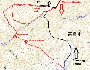
After marking the waypoint on my GPS (N35 18.269 E135 55.309), we all continued along the ridge, arriving at Bobofuda pass without finding that corroded signboard on the ridge. Now the mystery was starting to deepen. We had somehow climbed to a different ridge than the main one, but which ridge? The only way to remedy this was to retrace our steps back towards the summit until we found the last place we remember seeing the trail, which was a rotting signboard 500 horizontal meters from the pass. Ted, Miki, and I halted here for lunch, which Dominic continued pushing for the summit. We had driven separately, so there was no need to wait for his return. As we retraced our route towards Bobofuda, we found the place where we made the mistake. As you descend a small hill, the route becomes difficult to pick up, even without snow. The real path headed straight on, but we had actually veered towards the right and into Yokotani, in the opposite direction from Hata village. All this time I thought we had veered down the eastern slope of the mountain but we actually headed west. Peering through the trees, we spied a parallel ridge on the other side of Yokotani, which must have been where we climbed up to. Boy, we sure did end up a long way away from that village that day, thanks to those animal tracks and our foolish decision not to backtrack.

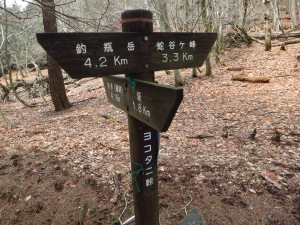
Once back at Bobofuda, we noticed that there was a trail running through Yokotani, but the signpost labeled it as 難路 (difficult route). We followed this path down into Yokotani and discovered that it appeared to cross the creek and head up to the neighboring ridge. Though we did not have time, both of us were confident that if we had followed this trail we would likely find that corroded signboard that caused us so much confusion!

So this is the likely scenario: we veered off the trail, entered Yokotani, climbed up to a ridge parallel to the main one, followed a trail that would have taken us off the mountain if we had stayed on the ridge (though we would have been over 20km from our car and in a completely different prefecture). Instead, we veered off the trail, using our compass to tell us which way was southwest. In essence, by leaving the ridge, we were actually heading in the right direction after all. We just had no idea there would be a steep gorge and another ridge between us and our car. By dropping off the ridge, we likely entered the same watershed (Yokotani) that we had left the first time. In all likelihood we were a lot further down the river and probably not too far from a paved road, which could have saved us. Then again, if you look at the contour map, you’ll see that the river is pretty much surrounded on both side by cliffs. After I fell into the ravine, we climbed back towards the ridge on the left bank of river, which happened to be the ridge just above the village. Mystery solved.
The only way to prove this would be to actually traverse that parallel ridge and also to have a look in the river itself to see if any of my missing gear is there. The best way to do this would be to start at the bottom of the valley where the paved road enters the tunnel to Hata village and to do sawanobori from there, with a helmet and ropes to help. Any volunteers?

After safely returning back to the car, we drove into Adogawa, passing by the very same police box where we had to fill out the paperwork, followed by the same convenience store where we had feasted that night. All in all it was a successful reconnaissance mission back to the scene of our fight for survival. I think Ted and I can now close a chapter in our hiking lives and return to exploring safer, more established routes as the warmer seasons approach.
Read Full Post »


