Feeds:
Posts
Comments

Archive for the ‘Hokkaido hikes’ Category

July’s Calendar Photo is from Shokanbetsu, so instead of the monthly ‘calendar footage’ post, I bring you this love-overdue report from the archives:


The sleepy coastal town of Mashike sits snugly against the towering peaks of the Shokanbetsu range, a magnet for frigid precipitation during the winter months, and heavy fog during the green season. Along the main street a row of buildings dating from the early Meiji era stand out among the newer, rust-stained concrete of the post-war structures. An old kimono shop sits idle, the old shell transformed into a local history museum. I wander through the empty rooms, admiring the striations in the glasswork of the windows. A few doors down, the volunteers at the local sake factory distribute free samples to a busload of tourists pausing briefly before heading to the flowery hills of Furano. Near the end of the street, just before the deserted train station and bus stop, an aging, weather-tained facade with arched windows and a recessed oak entrance serves as my accommodation for the evening. The proprietor, a young family of transplants from Osaka, take me in as one of their own, offering not only a warm meal and drinks, but practical hiking advice for my ascent of Shokanbetsu planned for the following morning.

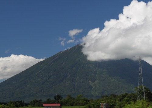
“There are three routes up the mountain”, explain my guide, “none of which are particularly easy”. With rain spitting down outside, this is not the news I want to hear. Still, I bite my lip and absorb the knowledge, deciding in the end to go with the shortest route up to the summit: a backbreaking 10km one-way ticket to the summit of what the locals have penned ‘Mashike Fuji’.

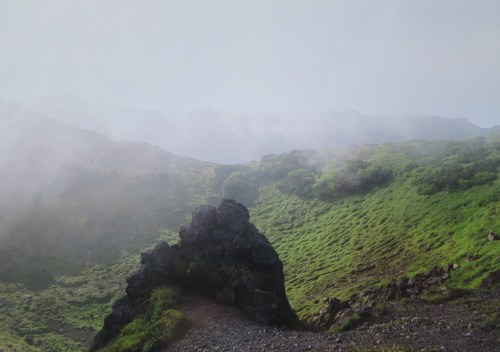
Bright and early, Grace meets me outside of the single-roomed structure that doubles as train station and tourist information center. After exchanging pleasantries, we file up the paved switchbacks to the 500 vertical-meter Hashibetsu trailhead. Thick cloud hangs heavy in the air as we unload the gear. The foliage is still dripping wet from the late night squalls that pushed in from the sea. We have one very long, sticky and sloppy hike staring us right in the face, so procrastination would do no good. Better to dive into it and get on with it.

The path is well trodden and easy to follow, but getting lost is the least of our worries. The humidity forces the sweat from our pores, which attracts the mosquitos and horseflies. Swatting is an exercise in futility, and the only way to avoid the persistent buggers is to keep moving. The trail is framed on both sides by head-tall bamboo grass, concealing the forest floor and the creatures that lie in the murk. After several minutes of tramping, we come across our first bear prints that couldn’t have been more than several hours old. Unfortunately it appears that we are tramping along an ursine highway, and Grace’s bear spray does little to calm the nerves. If we are lucky we can catch up with the creature and surprise it from behind, but there would be nowhere to go if we met the mighty brown bear head on.

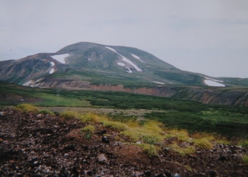
The mountain, like most other volcanoes in this land, is neatly divided into 10 stagepoints which does little to brighten our spirits. In anticipation of the long approach and summer humidity, I had brought along 4 liters of water, but the clouds cool things off enough to have me rethinking my decision. At stage point number 3 (san go-me), I stow away the extra two liters behind the signpost, and notice a much softer prance in my footfalls. My frowns from the previous hours fade away as I sink into a gradual rhythm and enter my tozan zone. The first 4 kilometers of the hike are almost completely flat, and it isn’t until the 5th stage point that we start to rise out of the flatlands along a deep gully eroded away by the torrential rains that frequent this dormant volcanic massif.

Grace and I break into conversation now and again as she updates me on her hiking schedule. You see, she is embarking on a rather unprecedented mission to knock off every single one of the 200 and 300 famous mountains left in Hokkaido, a hectic schedule that consists of nearly twenty peaks dominated by long, exposed climbs. Her mountain adventures have earned her the moniker The Yamaholic, a fitting name for the forty something dekasegi who grinds out a living in a factory in rural Toyama Prefecture. If her dream becomes realized, she will be the first foreigner to complete the entire Sanbyakumeizan, so getting these remaining peaks checked off the northern island will go a long way towards meeting her goal. I really admire that kind of spirit and determination, as I had abandoned my own quest long ago when the first stages of asthma set in. Still, I do have an intention of knocking off several of the peaks from that list of mighty 300. From the pictures in my guidebook, I’ve always had a longing to climb Shokanbetsu, and being able to do it in the company of the Yamaholic is an added bonus.

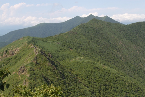
After another hour of ascending, we finally rise above the thousand meter mark and towards the edge of the tree line. The clouds are playing a game of hide and seek with the surrounding peaks, but in those brief intervals we can just make out the edge of the wetlands of Uryu to the south. Uryu marsh is one of Hokkaido’s hidden spots of ethereal beauty. In fact, a lot of visitors actually prefer climbing Shokanbetsu from this southernly approach, as the marshlands teem with wildflowers from June to October. There’s only one problem with the Uryu route: it is 23km round-trip to the summit and back, something that even us seasoned veterans can not muster up the stamina for.

At the 7th stage point (nana go-me), the bamboo grass yields to vast gardens of wildflowers of every imaginable shape, color, and size. The Yamaholic breaks into a huge grin, the first of the day after setting out earlier that muggy morning. The terrain morphs to alpine tundra as the views to the south open up. Clouds are moving in swiftly from the sea to the north, however, so our vistas are soon erased by the mist.

10 minutes past the garden we stumble across fresh scat the size of a rugby ball. Luckily the cloud hides the bear from our sights but if there’s one good sign to seeing gargantuan bear excrement it’s that the creature is very well-fed, meaning it is less likely to seek us out for lunch.

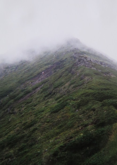
Soon we hit a junction where the two routes from the southern approach turn into one for the final push to the high point. The Shokan route is also a popular route and follows a parallel ridge up the spine to the summit plateau. The weather had kept the other hikers at bay though, and shortly after noon the Yamaholic and I stand next to the small shrine and summit marker affixed to the top. We give each other a high five and dig into our rice balls while waiting for the clouds to clear. Dreadfully, the mist refuses to budge, so we stare at the photos in our guidebook and use our imagination to trace the outline of the sea directly below. Drops of rain begin to fall just as we finish repacking the gear, and soon we find ourselves in the midst of one of those notorious Hokkaido squalls that put your rain gear to the test. We fly out of there like mice fleeing a cat kennel and drop back down into the sheltered coves of the treeline just as the rain peters out.

I pick up the two-liter I had stashed earlier that morning and we continue the descent through a fresh layer of ankle-deep mud. Once back in the flatlands the sun makes a late yet welcomed appearance as we brace ourselves for another blood feast. The mosquitos go to town but the spirits remain high after knocking off one of Hokkaido’s toughest day hikes.

The Yamaholic drops me off in Asahikawa as she continues her journey to the next mountain. I, on the other hand, take a well-deserved weekend off by crashing at a friend’s place while preparing for the ferry back to Honshu.


Read Full Post »

At the far eastern tip of the Kameda Peninsula near Hakodate sits an active stratovolcano named Esan. Rising directly from sea level to a modest height of 618 meters, the double volcano is the southernmost active volcano on Hokkaido island, and my destination for an overcast morning in late August. I boarded a bus from Hakodate station for the hour-long journey to the start of the route, which sits directly on the shoreline.

esan1

The initial part of the climb is on a paved public road that skirts past an abandoned elementary school before passing a temple with an immense gold-tinted Kannon statue. A bit further on, a hot spring hotel sits alongside a pair of vacant holiday homes: a surefire sign that the economic bubble had long burst.

esan2

I followed the quiet road through a series of sharp switchbacks toward a vast green plateau pockmarked by pumice boulders from previous volcanic hiccups. Due south, across the Tsugaru Strait, the mountains of Aomori Prefecture spread along the horizon, the tops capped with a beret of gray cloud. The road terminated at an empty parking lot and shut visitor’s center. I turned east, faced with an immense mass of igneous rock hissing with venomous gas. For the time being, the fog was held at bay but the pressure on my barometer was heading south quickly.

esan3

I picked up the pace, darting through the debris field like a soldier navigating a mine field. Once on the path it became a matter of following the paint marks on the rocks to the skyline. The winds picked up from above, smothering me with noxious fumes. I covered my nose and mouth with a dry towel and trotted through the thick stench while gasping for oxygen. This was not the smartest of plans, but turning back now would be accepting defeat, something that was not on my lunch plate.

esan5

Shortly before the high point, the fog enveloped me, but I pushed on and reached the summit marker a few minutes later. Somewhere beyond this white void a rumble crescendoed past. Did that burp originate from the heavens or the depths below? No time to loiter.

I hit the ground running,  just as the clouds emptied their bladders. Forget switchbacks: I scurried straight down the behemoth as the rumbling drew closer. Once back out of the cloud line the rain turned horizontal as a lightning bolt ricocheted off of Mt. Kaikou, barely 2 kilometers away. I screamed, turning my horse trot into an olympic sprint.

esan4

I made it back to a rest shelter next to the visitor’s center and stripped off my drenched gear. Fortunately I had brought an extra layer that remained dry and tucked into lunch as nature continued the electrical show. Eventually the storm passed and I retreated back down the main road and to the bus stop. Esan put up one heck of a battle, but victory was mine. I’d still like to have another crack (no pun intended) at the mountain in more favorable conditions.

Read Full Post »

“Excuse me, are you with UNESCO?”, inquired the middle-aged hiker, the third such person to pose such a question on my climb through the unspoiled forests alive with vibrant greenery. Apparently there were some UN officials in the area, but for reasons I had yet to discern.

apoi1

The train chugged south from Tomakomai city, passing abandoned train stations and fields of corn, soy, buckwheat, and other grains of unidentifiable origin. I rode the Hidaka line to the terminus of Samani station, where a shuttle bus whisked me to Apoi Lodge, my accommodation for the evening. After dropping off my excess gear, I peered out over the valley and towards the summit of Mt. Apoi, capped by a dense wall of cloud. With the weather forecast to worsen, this was perhaps my only chance to investigate one of Japan’s more peculiar geological anomalies.

apoi2

Bear warning signs marked the entrance to the otherwise nondescript trail, but I seriously doubted the validity of those warning signs. The peak juts right up against the coast, and with the rest of the Hidaka mountains providing ample stomping ground for Japan’s grizzly cousins, I cruised through the forest with relative ease. At one point in the trail, a large bell sat off the right edge of the well-worn path. Its use was apparent, so I rang the metallic device, which sent an ear-splitting drone deep into every corner of the forest. I’ve heard temple bells with less firepower than this monstrosity. While I’m sure it would send every bear scurrying for cover, it has the added drawback of sending every animal into hiding. That’s the main reason why I never use bear bells: you’ll end up scaring the deer, boar, martens, foxes, and other relatively harmless creatures away.

apoi4

As the trail meandered through a series of switchbacks, I ran into the first crowds of the day, and the first inquiries into my affiliations. Once reaching the 5th stage point (and psychological halfway point), I took my first break, resting on a small rock formation sitting directly adjacent the small emergency hut. All of a sudden, the clouds covering the summit plateau began to break up, as if on cue from Masaaki Suzuki himself. The early bird hikers had summited too early, but my mid-afternoon timing seemed impeccable. I quickened the pace lest the fog return for an encore.

apoi3

At the 7th stage point the trail broke past the tree line and onto a plateau bursting with wildflowers of every imaginable color. Apoi is home to quite a few species of rare endemic flora, but in my botanical incapacity I could not identify them without a guidebook. My altimeter read 500 vertical meters, such a low altitude to be above the forest canopy, I pondered. The views opened up towards the cold waters of Pacific as the path navigated through the creeping pine and along a rocky, knife-edge ridge for the final push to the top.

apoi5

Just before the high point the trail shot back into a grove of Erman’s birch trees, concealing the panoramic views you would expect to find normally associated with alpine vegetation. How can this be? This geological enigma continues to baffle scientists. Normally Erman’s birch (known in Japanese as dakekanba), sit on the edge of the tree line, with creeping pine (haimatsu) above, but here on Apoi the dakekanba appears above the haimatsu zone, as illustrated in the following diagram:

apoi8

Eager for a vista, I dropped halfway down towards the saddle below the summit of Mt. Yoshida, which offered a glimpse of the remainder of the Hidaka mountains stretching out to the north. Forget Daisetsuzan. If you want to experience Japan’s only true remaining wilderness area, then the Hidaka’s are the way to go.

apoi6

After retracing my steps to the summit, I continued south through patches of wildflowers before looping back on a shortcut spur back to the 7th stage point, where the clouds once again moved in. Retreating to the sheltered canopy of the tree line at the emergency hut, I ran into a trail maintenance volunteer. “Are you with UNESCO?”, he asks, my fourth such inquiry in as many hours. He explains: “Mt. Apoi is up for consideration by UNESCO to become a World Geopark site. Committee members are due for a surprise site visit at any moment.” Ah, now that explains the wide-eyed looks and inquisitory behavior.

apoi7

Now that I had found someone familiar with the peak, I rattled off a series of questions in a machine gun manner. Affirmative was my initial suspicions about the lack of bears, as even the trail worker was not carrying a bell. The two of us descended together, he interested as much in my mountain pursuits as much as I was in his floral knowledge. At the trailhead I stopped by the visitor’s center to check out the informative displays before returning to the lodge for dinner. The next morning the mountain was hit with torrential rain and violent thunder, leaving me thanking my lucky stars that I had chosen to summit the previous day. If the weather is good, then you should seize the opportunity to climb, even if it’s not on your agenda for the day, as delaying an attempt may just cost you.


Read Full Post »

After a fitful sleep, I cooked the last of my supplies before packing up and hitting the trail. The fatigue from yesterday still hung over me like a swarm of hungry gnats. The rays of sunlight peeked from behind a bank of cumulus. If I hurried to the ridge I just might get some long sought-after vistas. Biei-fuji’s curvy cone rose majestically to my right, but I skipped the summit in favor of the craggy spires of neighboring Mt. Biei. I crawled up the crumbling slopes, losing one step with each two taken in a futile duel with gravity. Clouds began rising from the valley below, threatening to steal my cherished views. I pushed myself harder than ever, clambering up the last few meters until topping out on the shores of a gargantuan ocean of mist.

daisetsu5-4

Dropping my kit, I stood, mouth gaped wide, as nature put on her spellbinding performance. Mt. Tokachi pierced above the clouds like a lean-to placed gently among a softly sculpted field of snow. A deep gorge of hissing and steaming plumes of volcanic gas intermingled with the rapidly rising fog bank, two angelic figures engaged in a choreographed ballroom dance as I stood on the sidelines taking notes. Turning ninety degrees, the entire Daisetsuzan range that occupied my time for the last 5 days stretched out unabated, proof of my interminable drive to persevere through it all. Despite the rain, fog, wind and long distances, my trek had finally reached a point of unwavering bliss; even though I was stripped of panoramic views on both Mt. Asahi and Mt. Tomuraushi, the scenery spread out before me more than made up for it: I was bit by the hiking bug in a major way, the implications of which would alter the course of my tenure in life.

daisetsu5-3

Dreadfully, the clouds soon caught up with me, swallowing me in its entirety as I started on the long slither across the boundless scree fields of Tokachi. Although only 30 minutes as the crow flies, the journey took the rest of the morning, as poor visibility and even poorer footing reduced my pace to an infant’s crawl. By the time I had reached the summit I had lost all drive to continue. I needed nourishment and fast, but what edibles could possibly remain after such a long journey? I released the pack to investigate, pulling out my food bag to find a package of dried miso soup, a few grains of powdered milk, and a half-filled container of angel hair pasta. It was a meal fit for Bear Grylls, but I’d need some fire. As I reached in to pull out the stove, my hand came across a small hard lump wrapped in plastic. An elderly hiker had handed me a couple of pieces of candy on the climb up Tomuraushi, and here they were staring out at me. Hmm, miso-and-milk pasta, or apple candy?

daisetsu5-2

I put away my gear, sucking hard on the candy to try to squeeze every last morsel of energy from the sugar-packed coating. It wasn’t much but it gave me enough of a push to reach the junction for the hot spring. Mt. Furano, like Biei-fuji earlier in the day, would have to saved for another day. I worked my way through the accelerating winds and dense forest of cloud, reaching the top of a maze of stairs leading down through crumbling tufts of pumice. Hundreds upon hundreds of stairs stood between me and a hot bath, but the pressure of a relentless descent started to take hold, and my right knee let out screams of pain with each successive jolt. I had done the entire trek without a pair of trekking poles and I was starting to pay it. Once the path flattened out I was in a pirate’s limp, reaching the hot spring in time to refuel the body with both grub for the stomach and muddy sulfuric grub for the muscles.

daisetsu5-1

Next on the agenda was a ride back to civilization, but first I had something else on my mind. I stuck out my thumb, and the driver gawked at my destination: “Fukiage? But you just had a hot spring!” The driver dropped me off a few kilometers down the road to the bath entrance, a 10-minute jaunt down a narrow mountain path. Fukiage gained fame in the 80s TV drama Kita no Kunikara, and the twin outdoor baths set in a thick forest of natural vegetation are a sight to behold. I stripped, soaking my spent body in the therapeutic waters. Unfortunately my peaceful soak was cut short by a group of camera-wielding Chinese tourists, who came to rubberneck at Japan’s endemic culture of grown men marinating naked in the great outdoors.

daisetsu5-5

Once back out at the main road, I caught another ride a few more kilometers to a campsite, where I had planned to pitch my tent but got distracted by a brand-new hot spring accommodation called Hakuginso that had just opened. Not only was it affordable, but there was a kitchen that guests could use to cook meals, and the maze of outdoor baths in the garden made it a no-brainer. I settled into my room just in time to watch the rain fall in heavy sheets. Thus I had ended my trip in preciously the same way I had begun: in a sparkling new guesthouse in the company of Hokkaido’s ill-fated weather.

Read Full Post »

At dawn, I crawled out of the tent to clear skies and a sea of cloud resting on the valley below. I thought about climbing back up to the summit to take in the views but I had another really long day awaiting, so after breaking down camp and stuffing a cereal bar down my throat, I bade farewell to Hiro and Maki and continued along the ridge.

daisetsu4-3

The route passed through a sea of bamboo grass, the maintenance decreasing in direct proportion to the distance from Minami Numa. I had finally reached the least traveled part of the traverse: most folks escape down to Tomuraushi hot spring before rejoining the mountain range further south at Tokachi. I fought my way through the overgrown mess, sweat darting from my tangled mound of hair like a malfunctioning sprinkler. Rays of sunlight pierced the openings in the foliage, transforming the landscape into a heat-shimmering sauna. Looks like summer had finally arrived on the roof of Hokkaido.

daisetsu4-2

After several hours of stamina-zapping movement, the path opened up to a series of broad hills, whose contours guided me to a deep col sitting on the doorstep of the 2000-meter summit of Mt. Oputateshike. The humidity and heat had attracted the clouds, blotting out the peaks like an ashtray full of spent ash. At the low point in the valley stood a flat area with room for no more than two or three tents. A group of university students occupied the largest of the sites, tent pitched among a latte of thick mud. An ideal place to spend the night this was not, so after chewing on some beef jerky, I loaded up the gear for the agonizing march up the final climb of the day, losing the path countless times in the dense fog and escalating winds. The crawl to the top easily took two hours: the last three days of full-on trekking were taking its toll.

daisetsu4-1

Once topped out, the pitch mitigated before dropping abruptly to yet another col at the front door of Biei-Fuji. A spur led to a small wooden hut situated on a flat shoulder of the volcanic cone. I dropped my gear and peeked inside the lodge. There was capacity for around 20 people, but I was shocked to find a group of nearly 40 occupying every square inch of the facility. There were even people who had laid their sleeping bags in the boot-covered entrance. I felt like telling them to bugger off and camp outside so I could have a warm place to sleep. After all, they were people who had just entered the mountain earlier that day, while I had been going nonstop for the better part of a week. In the end I asked about water sources and retreated to the lonely mist of  the deserted campground.

daisetsu4-4

After setting up camp, I searched in vain for the only source of water: a small snowfield situated somewhere in the valley below. For the life of me I could not find it, and with darkness quickly setting in, I gave up, opting to filter and boil a puddle of rain water sitting next to my tent. I had reached a low point in my trek, but luckily there was only one more final push to the hissing steam vents of Mt. Tokachi, the final peak in the traverse.

Read Full Post »

The torrent continued the entire night. Upon waking at daybreak, I lay in the tent in a rain-enduced trance. Not wanting to soak my kit or myself, I simply decided to wait out the storm, no matter how long it took. I rolled back over and drifted into unconsciousness again.

daisetsu3-3

Around 9am I awoke to the sound of birds singing. Unzipping my rain fly, I poked my head out in disbelief: the day before there were over 20 tents pitched in a labyrinth but now there was only one other, situated directly across from me. My gear shuffling had snapped my neighbors out of their slumber and they too looked google-eyed at the deserted state of our village. We both laughed, congratulating ourselves on the decision to make a late start. “My name’s Hiro,” offering his hand in a jovial western fashion, “and this is my girlfriend Maki.”

daisetsu3-2

We shared breakfast under the dissipating cloud cover while discussing our trekking itinerary. The were headed for Hisago-numa campground a half-day’s walk from here, while I wanted to push on to Minami Numa on the other side of Tomuraushi. We reached an agreement: Hiro and Maki would join me if I would be kind enough to keep a tent space for them.

daisetsu3-5

I left camp ahead of my companions, inching along the well-marked route through untouched swamplands before climbing the crest of a long slope. Here the terrain morphed into rolling hills sprinkled with boulders of every imaginable size. Depressions in the landscape framed ponds partially encased in ice, a reminder of the brevity of summer. Just past these frigid swimming holes a trail branched off towards the tranquil lagoon of Hisago, where a rustic mountain hut sat plopped on the far shore. It was straight out of a Snodonian daydream.

daisetsu3-6

From here the bedrock intensified, and it became a hopping game from rock to rock before the path vanished into thick cloud. The temperatures plummeted, forcing me to reach for an extra thermal layer in addition to my gloves. A few hikers worked their way silently from the hidden reaches of Tomuaushi above. I pushed on for several more hours before finally topping out myself. The views were obstructed but the climb was over. I dropped 10 minutes down the southern flank to Minami Numa campsite.

daisetsu3-4

I set up my gear on a quiet part of the sprawling campground, saving a bare patch of dirt for my new friends. Dinner was prepared and hastily devoured as the fog grew dimmer in the fading light. I relaxed in the tent, wondering if Hiro and Maki has given up back at Hisago. Just as I had resigned my fate to another night of camping alone, I saw two headlamps making their way through the maze of crags dotting the summit. My friends had finally arrived.

daisetsu3-1

After pitching their tent, they invited me in for rose hip tea and homemade cookies. These two knew how to travel in style. It was great to find a pair of kindred spirits with an immense love of nature and life. After dessert, the three of us split some fresh Hokkaido herb that had us flying higher than the clouds covering our camp.

Read Full Post »

Leaving the gear at camp, I strolled leisurely to the summit of Kuro-dake to usher in the new day. A dense layer of cirrostratus prevented the sun from hitting the peaks, but at least the lower cloud bank had stayed in the valley for the time being. After breakfast I broke down camp, strapped on the pack, and headed through a vast valley of snow towards the summit of Mt. Hokkai.

daisetsu2-1

Despite it being early August, the snow pack resembled late spring conditions. Hokkaido doesn’t have an official rainy season to wash away the massive drifts, so in parts of Daisetsuzan the snow remains year round. A few people milled about the summit, including a group I had passed the previous day on the ascent of Mt. Asahi. Instead of the extended leg to Mt. Kuro, they’d taken the direct line from Asahi to this peak, where they’d loop back to the thermal comforts of a nearby hot spring.

daisetsu2-2

I continued along the ridge another hour to Hakuun hut, a rustic structure resembling a giant lunch pail. Since it was still early in the day, the decision was made to traverse a few more hours along the route to the next shelter at Chubetsu. The path extended through a broad marsh-dotted plateau, flanked on the east by a cascade of rolling bluffs that dropped to a sheltered valley framed by a series of rolling hills of tongue-twisty Ainu epithets.

daisetsu2-3

Beware-of-bear signs reminded me to keep my eyes and ears alert through the Takane marshlands, but the mammals kept a low profile in the mid-day heat. The weight of my pack, filled to the brim with a week’s worth of provisions and gear, helped keep my pace moderate. Eventually the A-frame configuration of Chuubetsu hut came into view, marking the end of another calorie-burning day of trekking. I pitched the tent along side two dozen other domes scattered throughout the front yard of the unmanned structure. It was 3pm when I finally pounded the final stake into the dirt. The beams of ultraviolet bounced off the neighboring snowfields, with a distant roll of thunder providing an atmospheric soundtrack. Snow was gathered for melting in the vestibule of my nylon abode while I double-checked the velcro attachment securing the rainy fly to tent frame. Just as the snowmelt came to a boil the heavens opened up, deluging our wilderness playground and sending the mountaineers scurrying for protection.

daisetsu2-4

I cooked dinner and drifted off, serenaded by the shower-curtain chorus of a northern country thunderstorm. Could the change in the weather force me into a zero day?

Read Full Post »

Ah, Daisetsuzan National Park. The holy grail for Japan’s long trail community. Japan’s largest national park affords vistas like no other place. After an aborted trip last year, it was time to give the mountains their proper christening. As I stood on the edge of Sapporo city, thumb outstretched, I looked towards the plains of the east, hoping to catch a glimpse of their unhindered heights. An ash gray, 4-door Toyota sedan pulled up in front of my roadside perch. “Can you take me to Asahidake?” I inquired, using my best puppy-dog eyes. The driver, a father in his mid-40s, accompanied by his button smily 7-year old, willfully obliged. It turned out he was just out for a drive, but offered to take me all the way to the trailhead mostly out of kindness, but partly out of curiosity since they had never been to an active volcano.

daisetsu1-2

My initial plan was to camp, but the volcanic plateau was in a fierce battle with the elements when we arrived. Torrential rain fell from the skies as if to taunt me. “Are you sure you want to camp?”, ask my chauffeur. I definitely did not want to camp, and the sparkling youth hostel directly across the street from the campground made the decision for me. I booked a room while the driver bid me farewell, repeatedly refusing my offers to pay for gas. “We’ve just opened,” explained the manager of Shirakabaso, who gave me a quick tour of the grounds. This was hands-down the best hostel I’ve ever seen in Japan, at a true bargain at only 3000 yen a night. (it is now double the price) There was a Canadian log cabin annex out back, where a few other guests were browsing through magazines. During dinner, I got to know the other guests and we spend the rest of the evening solving riddles and telling stories, which helped me forget about the foul weather outside and my imminent engagement with the mountains the following day.

daisetsu1-3

The morning dawned overcast but dry, so I shouldered a week’s worth of gear and marched off to the start of the trail, which was marked by a stop-sign sized drawing of a cannibalistic brown bear with red Chinese characters warning visitors of their approaching doom. My stomach pushed tightly against my diaphragm as I bit my lip and swallowed awkwardly. What was I getting myself into?

daisetsu1-1

Since I wasn’t carrying a bell, I belted out some acapella in the loudest and most annoying tone I could think of.  It was as if Eminem were teamed up with The Offspring, but much worse.  Not only did I not see any of the caniforms, but my murderous bellowing most likely sent the other hikers scurrying to the hills as well. Actually, the first part of the hike was in absolute solitude, as 99% of hikers opt for the speed and luxury of the nearby gondola, which shaves 500 vertical meters off the climb.

daisetsu1-4

After skipping through some marshlands, I followed a narrow gully towards the ridge, topping out after about an hour of steady climbing. At the ridge, I met the trail coming in from the gondola on the left, where the crowds increased 10fold. Asahi-dake’s conical massif was hidden behind a thick layer of cloud. Further down the left side of the flank, a small caldera lake framed a canyon of steam vents which rose to meet the cloud layer. I skirted the outer edge of the lake before heading to the shoulder of the volcano on the right. It was tough going in the scree, but the path was easy to pick up thanks to the conservative placement of yellow paint marks every few meters or so. I reached the high point in high winds and zero visibility, taking off my pack in order to catch my breath and refuel.

daisetsu1-5

I headed down the eastern side of Asahi. The slippery scree gave way to even slipperier slush, as I did my best impression of a drunk ice skater. I somehow managed to stay on my feet through the maze of terror. I reached a small campground nestled on the edge of the snowfield, but I decided to make the most of the day by continuing on to Kurodake, which was home to a larger camp space with more amenities. Before me lay a vast igneous battlefield scarred with sulfur-stained gullies and hissing fields of steam. Imagine the Lake District sprinkled with a generous coating of volcanic seasoning. Since I had dropped back out of the cloud line, the route was easy to find. Signage warned of the dire consequences of veering too far off the trail, so I kept my wits about me, reaching the medium-sized hut at the base of Kuro’s summit plateau shortly before dusk. It was a long first day, but I knew that each successive day would require more milage if I wanted to make it to Tokachi by the end of the week.

Read Full Post »

There’s no doubt about it. Mt. Yotei was going to take a lot of planning if I wanted to pull it off. I had a 22-hour window between arriving in Otaru and departing in Muroran, and I needed every minute to count.

yotei5

The ferry rolled into port around 8pm, and I was one of the first ones off. Hailing down a taxi, I rushed to Otaru station in time to catch a southbound local train headed for Niseko. I made it to Kutchan station shortly before 9pm, where another taxi whisked me along route 5 to the turnoff at Hangetsu lake. I thanked the driver, dropping my heavy pack at the base of the toilets while studying the maps. A handful of tents were tucked away in the shaded corners of the tennis-court sized campground, but I wasn’t planning on loitering. A night challenge was in the works – If I could only find the trailhead.

yotei2

An unmarked gravel forest road led towards the direction of my target peak. Donning the headlamp, I eagerly followed, cautiously keeping my wits about me in case any brown bears came out to size me up. After half an hour of steady climbing, the road spit me out into a vast meadow of wild grass and weeds. In the dim light of the moon I could just make out the outline of Yotei’s conical crown. Expecting to find a signpost or signs of human encroachment, I was left with nothing but a forgotten forestry cul-de-sac. Dejected, I retreated back towards the parking lot. A few steps into my descent my headlamp flickered twice before extinguishing myself. It was dead, and I didn’t have a spare set of batteries. I picked my way back, tripping over tree roots and loose rocks before collapsing in a heap of sweat and fatigue at the base of the toilet block. Stowing my gear, I glimpsed a shiny piece of metal out of the corner of my eye. Retreating to the rear of the small shack, I found a giant signpost marking the entrance to the trail. In all my haste to race up Yotei I hadn’t bothered to search for the start of the trail in the campsite itself. Well, at least my headlamp malfunctioned here and not halfway up.

yotei1

I abandoned my nocturnal pursuit, ducking into my tent just after 1 in the morning. I didn’t bother with the rain fly, as I’d be up at first light in a couple of hours anyway. I set the alarm for the un-buddha-ly hour of 4 and drifted off into a deep slumber. The morning call came, and I woke myself up with a rapid bowl of oatmeal and dried fruit before strapping on the gear and hitting the trail. The path was incredibly easy to follow, and in hindsight I probably could’ve done it without a headlamp. The switchbacks, as in most stratovolcanoes, shorten the higher you go. At first you only switch directions every 10 minutes or so, but towards the crater rims those turns come faster than a downhill slalom course. Across the valley, Mt. Niseko Annupuri shined brilliantly in the early morning light, with a isthmus of puffy cloud rising rapidly from the ski-resort town of the same name. The clouds rose in direct proportion to my gains in altitude. It was as if they were racing me to the top, and since I didn’t want to be deprived of a view, I quickened the pace. I made it as far as the 9th stage point before I lost the footrace with the cumulus. Fog enveloped me in much the same way the smoke machines eats people at a Megadeth concert. I hunched over, catching my breath while trying to regain composure for the final push to the high point.

yotei3

When reaching the rim, I headed counterclockwise, arriving at the high point just as the sun peeked out of the cloud for an instant. I raised my camera to capture the scenery. The click of the shutter was followed by the click of plastic, which was further followed by the door of my camera swinging completely open, exposing all of my film to the direct light. Somehow the latch had broken and I had no way of closing my camera. It was still fully functional, so a quick fix was in order. I pulled out my first-aid kit, affixing band-aids all down the side of the camera until somewhat secure. Still, I knew all of my film would be damaged. This was in the days before affordable digital technology, and being stuck at almost 1900 meters above the nearest camera store meant I had no alternative way of documenting my climb. With my head hung low, I continued the rest of my circumnavigation in a childish sulk. Just to make matters worse, the clouds lifted at times, revealing the verdant greenery of the crater itself.

yotei4

In order to offer better access I dropped off the northeastern flank of the dome, crossing a vast field of wildflowers stretching out in front of the modest mountain hut. From here I entered the Makkari route, a knee-knocking, ankle-twisting descent that dropped straight off the peak into the dense forests of beech and birch. The route spit me out in a extensive campground bathed in a sea of soft grass. I stopped here to rehydrate and refuel before following the slope out to route 66. Turning left, I strolled along the busy byway, looking for a shoulder along the road where I could safely try to hitch. As I was walking, minding my own business, a car pulled to a halt and ushered me in. After showing me the sights of Lake Toya, the elderly gentleman dropped me off at Nagawa station, where I caught the train to Muroran with plenty of time to spare before my evening ferry ride to Aomori. My time management had rewarded me with another successful tick off the list.

Read Full Post »

The northern island of Hokkaido is a botanist’s wet dream, as the brutally cold Siberian winters give way to a paradise of palpitating perennials during the short season of warmth. At these latitudes, the tree line drops to as low as 1200 meters, giving flower hounds the opportunity to cherish alpine flora without the asthma-enducing altitudes of Honshu’s higher peaks.

Over the last decade or so, I’ve been witness to dozens of dazzling displays of pollen throughout the entire island, though I have never taken the time or effort to put those latin names into long-term memory. Most of my forays into Hokkaido’s alpine zones have resulted in a child-like rendering of glee, with such insightful expressions as “look at the blue flower over there” or “the small yellow ones are cute”. Could it be time for a more informed course in alpine plant-ology?

For this I ask your assistance. If you happen to know the names of any of the flowers in this post (either Japanese or Latin terminology will suffice), then feel free to pass your knowledge on to me through the comments section.

My next step will be to buy a guide to alpine flora, so if there are any ‘must have’ Japanese floral guides, then please let me know. So, without further ado, I present Ezo’s Guide to Unknown Alpine Flora:

IMG_5322 IMG_4770 IMG_4816 IMG_5433 IMG_4626

Read Full Post »

Older Posts »