Feeds:
Posts
Comments

Archive for the ‘Kansai hikes’ Category

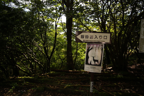
The Suzuka mountains may best be known as Nagoya’s playground, but that doesn’t stop this Osaka resident from making every effort to explore the entirety of the range. It doesn’t hurt to have a local companion willing to share in this mutual love for the area. Hisao points his car in the direction of Mie Prefecture for a second look at Oike, the highest peak in the Suzuka chain. My first trip here involved a monumental effort after the closure of route 306, but with the Mie-Shiga thoroughfare once again open to vehicular traffic, we make a bee line to Kurakake-tōge, the easiest approach to the ridge.

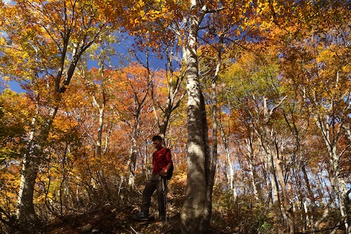
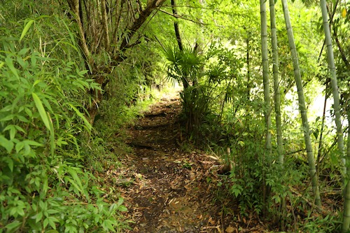
Under partly clouds skies on a weekend in late September, Hisao and I scoot into one of the last remaining parking places just outside of the Kurakake tunnel entrance. After a brief shuffle through our gear, we shoulder the packs and follow the switchbacks past the tattered ruins of a corrugated metal shack and onto steep slopes dotted with purple monkshood flowers shimmering in the gentle breeze pushing in from the east. The path narrows in places, with fixed ropes aiding in a hairy traverse across the dizzying drops of a narrow gully clogged with toppled timbers. It takes just 20 minutes to reach the junction on the ridge. A right turn here leads hikers to Mt Mikuni, a aptly-named summit situated directly on the border of Shiga, Mie, and Gifu Prefectures. It’s hard to believe that Gifu Prefecture stretches so far south to touch the Suzukas but Japan’s 47 prefectures have been crafted like an intricate jigsaw puzzle that defies belief.

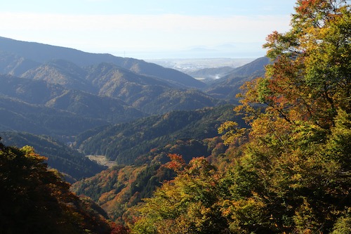
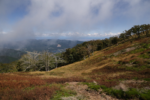
While the chance to place three different body parts in neighboring prefectures does seem tempting, we instead turn our attention south and head left on the well-traveled walkway toward Oike’s imposing figure. Our route follows an undulating ridge offering enticing vistas out to the blue waters of Ise Bay, with the path ducking in and out of the hardwood forest before skirting past a rusted electrical pylon in need of some upgrades. A dead grove of brown ferns sits to our left, while moss-coated oaks on the western slopes seem to make the most of their moist environs. After traversing up and over a few nameless bulbs on the ridge, we pop out onto a path of loose scree running through what can only be described as a massive moss garden. The maps call this place a Japanese garden and it is easy to see why.

Hisao and I let out screams of delight as we become enveloped in the unique scenery. To the north, the clouds have engulfed the ridges of Mt Ryozen but it does nothing to deter from our delight. Some may even say that the shade provides even better lighting to capture the verdant blanket of green beneath our gaze.

The line of electrical pylons stretching across the neighboring slopes, while marring the landscape, do little to detract our attention. Finding such a sprawling network of flourishing moss is rare indeed, and one has to wonder if Fukuda Kyūya would have chosen Oike instead of Ibuki if he had a chance to discover this part of the Suzukas earlier in his life.

Then again, the Hyakumeizan author may very well have been put off by the plethora of leeches that have invaded the land over the ensuing decades. At least on Mt Ibuki you don’t have to worry about having your blood sucked by the persistent segmented worms. Fortunately for us, the leeches prefer gullies to ridges and as we climb hiker into the encroaching fog, all thought of the gruesome creatures vanishes from our thoughts. That is, until encountering a trail-running duo on the summit of Mt Suzukita, the first of Oike’s multitude of smaller summit peaks.

“Which path did you take?” I ask, curious about the trail conditions further below.

Kogurumi valley,” responds the taller of the two.

“How were the leeches?” I enquire, hoping to squelch my fears.

“No problem,” comes the reply.

“Then what’s that attached to your leg?” exclaim I, as a small leech clings comfortably to his left shin.

The runner reaches down and casually removes the bloodsucker as his companion looks on with disgust. I turn to Hisao as we both break into laughter at the scene unfolding in front of us.

Up here on the bare ridge we feel the full brunt of the winds, so after this quick exchange of unpleasantries Hisao and I continue our march south toward the summit plateau. The main route veers left at the bottom of the next col but Hisao beckons me to follow him to the right along a rarely-trodden path no wider than a foot width. Although we are most likely following the imprints of a deer trail, my leader truly knows where he is going as he has been through the area on snowshoes in winter. Hisao looks as if he’s on the hunt for fresh game to supplement his lunch.

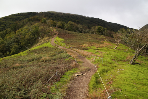
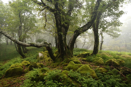
We push through golden grasslands dotted with jagged Karst and sprawling carpets of lush moss until leaving the jungle behind in favor of the shaded canopy of the hardwoods entwined in a labyrinth of pastoral ferns and cushiony boulders straight out of Lord of the Rings.

It is easy to see why Hisao choses this route, for among the splendid scenery there are no other hikers, for they have all opted for the straight path to the summit for their proof photos and claims of having ticked another peak off of their mountain list. I certainly fell into that trap during my younger days, but when faced with climbing a mountain a second time, I tend to prefer a more thorough exploration of the slopes.

Carefully we pick our way through nature’s maze, taking great care not to disturb the delicate moss as the contours coax us off the northern flank and down to an idyllic tarn labeled on the map as Moto-ike (本池). As I study the map further, I realize that the entire area is dotted with hidden lakes and ponds which explain the origin of Mt Oike’s name, which literally means ‘honorable pond’.

With such breathtaking scenery spread out before us, our pace grinds to a crawl as every turn affords even more impressive scenery than the last. Lush forests give way to golden grasslands that further yield to sprawling fields of Kharst before once again leading us through yet more incredibly alluring forests, all under the playful eye of an overhead struggle between the swift-moving fog and the piercing warmth of the sun.

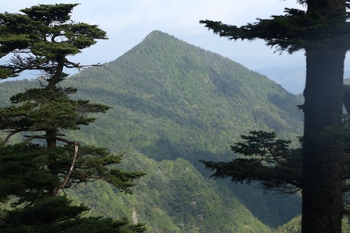
Eventually the forests give way completely to a colossal tableland straight out of an African textbook. I resist the urge to break into a Toto song so instead give out several yelps of joy as we clamber up to an outcrop called the Tengū’s nose, which give us a bird’s eye view of contorted folds of ridge encompassing the eastern past of the Suzuka massif. Just below the thick cloud bank the sunny shores of Lake Biwa peek out to say hello.

We race down from the cliff’s edge and make out way over to yet another outlook by the peculiar name of Botanbuchi. We rest among the rock formations and take in the mesmerizing views. It is now half past 11, and with very few hikers in sight, we settle down for an early lunch while alternating our gazes between the limestone cliffs disappearing from beneath our outstretched legs in front of us, and the unparalleled beauty of the golden tablelands stretching out behind.

“Are we really in Japan?”, I ask Hisao, wondering how I could have missed such incredible scenery during my first visit to this mountain. I thank Hisao profusely for convincing me to give Oike a second look, for it truly is one of the best peaks in the entire Suzuka chain.

Feeling refreshed, we meander through the plateau and up onto an adjacent ridge which takes us up and over a very crowded summit. Hikers area spread out among the jagged rocks, taking shelter from the winds and enjoying their midday meal. We opt not to loiter for anytime longer than necessary to snap a quick photo before ducking back into the lush forest and onto the well-trodden main route back to the car.

By now the fog has completely engulfed the mountain, bringing an entirely new dimension to the forests—one of enchantment.

This spell that the mountain has cast upon us is briefly broken as we skirt through a narrow valley and up into unexpected sunshine. Hisao once again leads me off-trail to a hidden pond called Kita-ike or northern pond, a tarn that very few hikers bother to take the time to visit as they all stick to the same up-and-back path to the high point. From the narrow shores of the waters we are able to follow the natural contours of the land as they lead us back to the summit of Mt Suzukita, thereby completing our rather extended loop of the summit.

From here it is simply a matter of retracing our steps back to the car and through the garden of moss, which never ceases to impress us even on the second time around.

On the walk back to the car, Hisao informs me that Oike is even more outstanding in the winter, and on our traverse back through the forest I do notice a piece of tape affixed to a tree that is used to demarcate the entrance to the winter route from the Shiga side of the mountain. Perhaps I will take Hisao up on his offer for a third round, for by now we can all realize that my fellow companion can be highly trusted with his mountain recommendations.

Read Full Post »

My first visit to Mt Yokoyama entailed a tricky ridge scramble on rotting snow. Despite the difficulty with the snow conditions, the virgin beech forests clinging tightly to the mountain contours left an impression on me, and I vowed to return during the foliage season. Fast forward a few years to early November, and when pressed for a recommendation for an autumn hike, I immediately suggested to Hisao that he give Yokoyama a chance. Tucked in a forgotten corner of northeastern Shiga Prefecture, it would take an early start and a bit of planning to make it all work. Hisao happened to be in town for the Banff Mountain Film Festival, creating the ultimate opportunity to see our plan bear fruition. After a day of inspiring movies, Hisao and I head back to my home for an early night and long day ahead. We set the alarm for 4:30am, but I am awake by 4, excited by the promise of a beautiful day.

We hit the road by 5 for the two-hour drive and roll into the parking lot right at 7am. The last several kilometers along the rural road from Kinomoto see our target peak basking in the dawn light—even from here the climb looks impossibly steep as the massif literally towers over the sleepy hamlet. After using the barebones toilet facility, Hisao and I study the map and wait for 10 minutes until Yasu and Kaori pull into the narrow trailhead parking lot. Excitement resonates through the air as the crystal clear skies greet us like an old friend. Our route this time is the famed Shiratani Honryū, a scramble up a steep mountain stream: a direttissima earning the respect of all those who commit to the steep contours flanking the southern face of Yokoyama. During our first visit, the village caretaker rushed up to the trailhead in his utility truck to warn us off the route in winter but now it is time to give the route its due shine.

A rugged forest road doubles as our access route for the first few minutes before abruptly terminating at the water’s edge for the first of a series of river crossings. Skyward we gaze at the blazing foliage coating the spurs on both sides of our narrow channel. Greenery still clings tightly to the hillsides as if to ward off the encroaching winter. I take the lead, following the faint track higher up the constricted valley. At the top of a gentle rise I gaze ahead and spy a trio of hikers making their way up a series of jagged switchbacks that terminate at a forest road cutting sideways a quarter of the way up the mountain. Despite the human development on the lower flanks of the mountain, the forests have somehow been spared the wrath of the desecrators who have destroyed Japan’s natural forests by smothering them in cedar and cypress.

After an abrupt drop flanked by fixed ropes to the river and a short scramble through a side tributary, we reach those switchbacks and make our way up to the forest road, the final few steps made easier via a steel ladder flanking the two-meter-high concrete retaining wall. Here we turn left on the gravel road for 100 meters before leaving the human development for good by returning to Shiratani on a path splitting off the right shoulder of the lane. Yet more river crossings await as the three of us commence on a somewhat steep ascent past the multi-tiered Kyō-no-taki (経ノ滝) falls. We pause briefly to delayer and admire the ribbon-like cascade.

Left the path goes, straight up a rope-smothered slope in fact, to meet the start of a narrow spur still sitting in the cool shade as the sun has yet to lick these secluded corners of the gorge. We force ourselves up the near-vertical embankment and onto the relative safety of the spur that leads above the falls and onto yet another series of river crossings. The track soon reaches a clearing, affording tantalizing vistas back toward our route and further onward to Kinomoto and the shores of Lake Biwa. To say that the scenery resembles a landscape painting would be an understatement, as we could literally have gazed for hours, entranced in the utter beauty spread out before us.

Higher and higher we rise to meet the slivers of sun working their way down the slopes. The warmth that it brings is most welcome as we have spent the entire morning in the chilly shadows of the gorge, and up through a latticework of fixed ropes we ascend, reaching the base of the multi-tiered Gochōshi Falls. Hisao erupts in delight, as his hometown of Choshi (銚子) city in Chiba Prefecture shares the same kanji characters as this waterfall. We take our first break of the morning here, wiping the sweat off our brows while taking in the vistas back to the valley behind us. We share a few snacks and bask in the warm rays of sunlight. It is just past 9am and most other the other hikers are probably just beginning to set foot on the trail.

From here it is a straight shot up to the summit, but first we need to navigate up and over the falls. Fortunately a track to our left grants us passage along a narrow, somewhat dizzying rope-lined traverse tinged with autumnal hues. You really have to focus on the terrain here and not get spellbound by the splendid scenery and lose your footing.

Above the falls the track veers left once again onto the crux of the route, as the angle intensifies. Fortunately for us, we have reached a different kind of intensity as we reach the peak of the fiery autumnal tones. I scream with delight at literally every step upward as a chorus of oohs and aahs follows.

Our pace grinds to a crawl and for good reason, for never in the Kansai region have I bore witness to such fierce colors set against only the most cobalt of skies.

At the base of a trio of horse chestnut trees towering toward the sky, I find a peculiar heart-shaped rock clinging to the steep hillside. Has it been placed here by a pair of star-crossed lovers, or just a lucky find among the scattered fragments of rocks interspersed among the freshly fallen leaves? Regardless, the golden hues of the broad-leaf chestnut provide a most fitting backdrop.

While the lightshow above is nothing short of stunning, a glance over to the neighboring spur sends us into an excited frenzy of shrills and adolescent screams.

I snap a photo at literally every step upwards, trying to capture just a tiny bit of the spectacle for others not lucky enough to witness nature’s perfection. Imagine how beautiful Japan must have been when every forest took on these deciduous tones every autumn. It is hard to find a mountain in Kansai that hasn’t had its slopes desecrated by the cedar planters, so when a completely untamed mountain presents itself for show, you had better pay it some respect.

Those words come to me in a semi-concussed state, for after navigating through a narrow gap in a rock formation above, I stand prematurely and smash my noggin up against a toppled beech tree, which has me seeing stars as I lurch forward to regain my composure. Luckily the smooth bark fails to create a puncture wound, so I can continue forward in a careful yet bloodless state.

Using this collision as an opportunity to slow up the pace, I gaze up toward my canopy of blazing reds and vivid yellows as we continue our steady pace along the ever-steepening spur. The contours on the map are so close together it’s a wonder there is any room for a path at all, and every 50 meters or so we clamber through some rock formations that have somehow managed to defy gravity as they cling to the rugged hillside.

Beech tree leaves do not retain their color for long periods of time, with the transformation from brilliant yellow to muted brown occurring over the course of just a few days, so we consider ourselves lucky with such perfect timing as to witness the brilliance of this autumnal performance.

The spur continues to steepen as we make our way through a network of bowed trees, crags and fixed ropes, punctuated at irregular intervals by rotting signposts clinging awkwardly to the gnarled slopes in a gravity-defying manner. Pink tape marks guide us upwards along the narrow spur, coaxing us along like signal beacons lining a crowded cove, but for us the harbor is crammed with towering beech, oak and maple. Finally, after the better part of an hour, the angle subsides and ushers us up onto the broad ridge of Yokoyama.

We pop out on the treeless summit at preciously 10:30am. A pair of hikers laze in the warm sun but apart from this duo, we find ourselves completely alone. One lonesome raggedy old prefab structure sits on the northern edge of the high point, looking even more lopsided that during my first visit to the mountain. Ignoring common sense, I scale the rickety metal ladder tied onto the side of the shack and scramble onto the roof looking for a glimpse of Hakusan to the north. Alas, the sacred peak is shielded from view by a series of smaller mountain ridges ablaze in autumn hues.

Lazing in the warm sunshine seems like the best course of action, and between mid-morning snacks our companion Kaori settles in for a power map while Hisao, Yasu and I gaze down at the shores of Lake Yogo, a tiny dot of a tarn as it appears from these hallowed heights. Yogo itself sits at the northernmost tip of Lake Biwa, separated by the sprawling ridgeline of the Sengoku-signficiant Shizugatake. The better part of 30 minutes is spent in such perfect reverie among the soothing air of autumn.

Eventually the four of us garner up the strength and courage to embark on the long-awaited walk along the spine of the range to neighboring eastern peak of Yokoyama. Although the main peak of Yokoyama is devoid of clear views, a short walk east takes visitors onto a narrow sliver of track affording vistas that can only be described as life-altering, for once slip down the rugged cliff face will do just that.

As we push on closer to the eastern summit, a solo hiker approaches on his way west toward the main peak, and as he passes, he offers us just the bit of news we were hoping to receive: the Alps are visible. This titillating snippet is all that it takes to send us in a frantic scramble to the east peak, where we do indeed find those ever elusive views north.

We can count no fewer than 10 Hyakumeizan on the horizon, in an expanse spreading west from Mt Arashima all the way across the horizon to Mt Ibuki on our eastern field of view. Between, Mt Ena looks on with envy as the faintly visible Chuo Alps run behind the imposing volcanic edifice of Ontake. Mt Norikura, Hotaka and Kasa also make an appearance along with the bald cap of Hakusan poking its snow-free head above a bank of white cloud.

With a tinge of reluctance, we bid farewell to the glorious views and duck back into the bare virgin beech forests, which slowly come to life as we once again descend below 1000 meters and into the peak of the autumn blaze. The colors come gradually: at first a lonesome maple against a backdrop of gray beech but slowly the colorful canopy begins to overtake us.

And overtake it does, grasping us in a viselike grip as if to say “you will walk slowly and give us our due respect.” And we give into the temptation and do indeed slow our pace to a crawl, smiles spreading across our contented faces as we search for the right words to express our appreciation.

21 years of hiking in the Kansai region and never have I encountered such perfect hues of autumn color.

As with all good things, they must surely come to an end, as we pass into the lower depths of the forest and right into a small sliver of planted cedar hugging the edge of a dirt forest road. It looks as if the tree planters started their clear-cutting but stopped short of a full-on invasion, perhaps with a tinge of guilt at attempting to destroy one of the best forests in western Japan. Or perhaps the hallowed beech groves of Yokoyama are on borrowed time. Regardless, I grasp tightly onto the fixed ropes guiding me down an incredibly steep track to the forest road, which eventually leads back to our vehicle.

We top off our trip by a short visit to an obscure old ore mine that Studio Ghibli fans have taken to call a real-life version of Laputa, a perfect ending to our flawless autumn trip to Yokoyama.

Read Full Post »

My first visit to Sasayama’s Mt Mitake and Kogane was a wintry up-and-back from Ōtawa-tōge to the northeast. The trip always haunted me, as it felt like we cheated a bit by driving most of the way up the mountain, resulting in my desire to give the peak a second chance. Cue my trusty companion Paul M. and his German neighbor Chris, who are keen for a late September hike not too far from Kobe. I suggest Mitake, and our plans are set for a beautiful Saturday morning.

Paul M. drives the car through light traffic past the sleepy village of Okuhata and to the small trailhead parking lot along route 301. It is 10am and the temperature is already in the mid 20s—so much for the cool autumn air. We shoulder the day packs and walk back down the pavement to a signpost affixed to the side of a traditional farmhouse. I’m not sure how the residents feel about their backyard sharing trailhead access, but the lack of a barking dog suggests that the owner may not mind the brief passersby.

A large adult praying mantis stares at us from the top of a plant lining the edge of the owner’s garden as the path ducks into the forest to commence the steep climb. Horizontally speaking, we only have a distance of 2.8km to cover but well over 500 vertical meters in front of us. Log steps lead us to the top of a broad spur lined with Mongolian oak and red pine. At the top of a small rise, a battered signpost informs us that there was once a resthouse for visiting Shugendō practitioners, and a bit higher up the spur we reach the ruins of Mitake-ji temple.

Mitake-ji temple was a Shugendō hotspot purportedly constructed by En no Gyōja himself but more likely by a monk in the 12th century. It flourished as an esoteric training ground until burning down in the late 14th century. Now all that stands is an explanatory signpost and a series of rock boulders strewn across the Taki Alps. The path steepens from here, and after passing by a small Buddhist statue built into an alcove, we reach a rock face affording mesmerizing views into the valley below. A weather beaten carving of En no Gyōja sits in a niche above the clearing, and while taking in the views of the rest of the mountain range, a giant Japanese hornet hovers to remind us that it is now breeding season.

We beat a hasty retreat and skirt past a few more rock formations before ducking into a dense cedar forest housing a covered picnic area with a porta-potty installed. A few steps higher and we reach the summit ridge, marked by a large rock shelter bolted shut with a gate. Peering through the gate reveals a modest altar lined with ancient stone carvings, so eroded that it is difficult to determine which deities are enshrined within. A broad rock formation sits above the shelter, but rather than rest here we turn left for the final few steps to the summit of Mitake. Unfortunately, a TV antenna and cell phone tower sit on the broad summit, marring the otherwise unobstructed vistas of northern Tamba city.

An early lunch is in order, so the three of us settle down on a circular concrete bench erected beside the triangulation point. Preciously one bite into my sandwich, a large hornet swoops in, circling around Chris and I as if holding a personal vendetta. Paul M. looks on with amusement, for the wasp wants nothing to do with him despite his red shirt. Unfortunately, Chris is dressed in black, a color for which hornets are known to love. Meanwhile, I am wearing an orange shirt and red backpack, apparently another no go color in the autumn. You see, hornets have trouble seeing color, so to them orange and red both appear as black, though I am wondering if hornets might also be attracted to the sweaty odor wafting from my stinky body.

After three rounds with the hornet, I trod off in protest and head to the rock formation above the stone shelter just below the summit. My companions soon follow suit—including the hornet! So instead of a leisurely break, we shoot down the eastern face of the steep peak, hornets in pursuit. Every 50 meters or so, a hornet would buzz by, leaving me perturbed and regretting my decision to hike in active wasp season. My only solace comes at the splendid mountain scenery, which is finally starting to show some autumn tones.

Through a gap in the trees, the craggy monolith of Kogane rises up majestically due east, with the narrow Ōtawa-tōge pass separating us from our target for the afternoon. We lose altitude abruptly, holding onto fixed ropes with one eye on the lookout for more dive bombing by the annoying Vespas. To make matters worse, at the bottom of a steep climb we encounter a trio of hikers, who inform us that the hornets haven’t been bad at all. Perhaps the creatures hold a personal grudge against foreign male hikers.

30 minutes later we reach a grassy field at the mountain pass and settle onto a bench under some cherry trees to finish off our lunch. Sure enough, another hornet makes an untimely appearance, but fortunately for us it appears after we have finished off our rations. The mountain pass is home to a modest parking lot and the recently erected Forest Adventure, a French-inspired treetop park of vertigo-including walks and adrenaline-releasing ziplines. The trailhead passes right through the park, and while the attractions do cost money to experience, we are content with just walking under and around the playground built in the dense canopy of cedar trees.

While this park was not present during my first visit, it is a welcome sight, as this depressing section of monocultural cedar plantations would otherwise be neglected and forgotten. The route follows a dry gully until reaching a series of log steps built higher up the spur. We turn left and ascend to the top of the spur at the base of a narrow crag. While the trail skirts around the rocks on our left, Paul M. drops his pack for an improvised climb to the dizzying top of the boulder. Chris and I observe from the comfort of more stable ground.

A long fixed chain dangles downward as I start the skirt around the boulder. Wouldn’t you know it, two steps into my descent a hornet flies directly up from below, engaged in a game of chicken that I want no part of. Fortunately my partners have yet to start their descent of the fixed chain as I let out a scream and embark on a makeshift retreat back up the chain. At the top I duck as the bee flies directly overhead. With the coast now clear, I restart my careful repel down the chain and reach the bottom with no other close calls.

The route up towards Kogane is draped with fixed chains along the sawtooth ridge, with a few hornets thrown in as an added obstacle. For some inexplicable reason I always seem to take the lead on our hikes, and I am convinced that all of my hiking companions are content with letting me be the first one to encounter all of the spider webs, insects, and reptiles.

Just after 1pm we pop out on the summit of 725m Mt Kogane, covered in sweat from the tricky scramble. The panoramic views help calm our minds after the climb, with fluffy cumulus clouds floating around the surrounding peaks. On yet another rotund concrete bench we brew up some coffee while fending off yet more hornets. I swear this is the last time I will hike in September.

The caffeine and chocolate help to fight off the fatigue and we turn due south along a near-vertical rock scramble that leads back into the forest along a narrow ridge past the temple ruins of the 12th century Fukusenji temple, which is nothing more than a flat area strewn with boulders and a toppled explanatory signboard that is slowly being returned to nature. A jizō statue is the only reminder that a great sanctuary once stood in its place.

It is here that we leave behind the ridgeline and descend through a narrow valley of loose moss-covered rock which leads to a narrow mountain stream. We follow the tape marks and about half an hour after leaving the ridge we pass through a chain-link gate and reach the outskirts of Okuhata village.

Asphalt would lead us back the car in a roundabout way, but spying a shortcut on my GPS, I lead our team past a small shrine along an overgrown path that dead ends at a chain-link fence. We can see the road on the other side, so we all scale the fence and navigate through a field of solar panels to reach the road back to the car.

All in all it has been a fun excursion in the hills, hornets aside.

Read Full Post »

Late August and a promise to fulfill. Paul M. has been suggesting a climb of Kansai’s highest mountain for years, and after climbing it a second time without him, I agree to escort him up the slopes of a peak that I vowed never to climb again. It’s not that I don’t like Mt Hakkyō, it’s just with two previous climbs under great weather conditions, it’s tempting fate to climb it a third time in an area known for torrential rain. Regardless, we leave Kobe in the early morning hours for the long drive along the incredibly narrow road that hugs the aquamarine waters of the Tenkawa in central Nara Prefecture. Most of the drive involves a tricky game of letting two-way traffic through on tight squeezes that are only designed for one vehicle at best. We finally arrive at the Gyōja tunnel trailhead shortly after high noon and rest in the shade for a hastily prepared lunch.

We shoulder our heavy packs, crammed with provisions for an overnight visit, and hit the trail just after 1pm under sunny skies and calm conditions. The initial approach along the left bank of the river is gentle, with no camping signs posted along the way most likely by the hut staff above, who are eager to collect income by forcing people to pay money to stay on top. Such capitalist greed runs rampant in the mountains of Japan, with an unspoken caste system dictating preferential treatment for those shelling out the big bucks to stay in the huts with meals, while the campers are often thought of as second-class squatters.

After crossing the wooden bridge spanning the stream, the start of what I call the ‘spur from hell’ commences. While incredibly beautiful with its diverse mixture of hardwoods, verdant moss, exposed roots, and unique rock formations, the shortest and most popular route to the World Heritage Okugake Michi is little more than an agonizing slog designed to destroy the morale of even the most optimistic hiker. At least that’s how I think of it, as my string of expletives grows longer with every lunge forward.

Paul M. and I reach the ridge line preciously an hour after setting foot, with both of us collapsing in a heap of perspiration and fatigue. The long drive has taken its toll, and I feel that I can go no further without some nutritional assistance. I pull out a caffeine gel, hoping that the drug will do its trick and help will me along upward. A five-minute pause to let the effects kick in and we start our walk on the historic route connecting Yoshino with Kumano, turning due west along a well-used track blanketed by a bamboo grass carpet, with a mixed deciduous and conifer ceiling providing an ample amount of shade from the piercing heat of the sun.

Past groves of purple monkshood flowers the trail continues, through an area of trees toppled by the the fierce winds of Typhoon Jebi back in 2018. We maneuver over and around the labyrinth before arriving at Benten no Mori, named for the Buddhist goddess of literature and music. As if on cue, the distant sounds of a conch shell reverberate through the valley from an unseen location high above: a weekend Shugendō warrior has made his presence known.

Benten no Mori sits at an elevation of 1600 meters, and a short descent on the far side of the rotund peak affords us our first views of Mt Misen and Mt Hakkyō, which sit high on a parallel ridge like a impenetrable feudal citadel. The route involves a direct ascent of Misen before swinging due south to the adjacent 1915m summit of Hakkyō, the highest point in the Kansai region. Luckily for us, we are in no rush and keep a slow yet steady pace, simply placing one foot in front of the other while relishing in the incredible beauty surrounding us.

After dropping to a narrow col, our rocky path continues along the ridge past towering beech, oak and hemlock trees casting a patchwork of brilliant shadows on the moss-covered floor. The piercing sound of a conch shell at close range startles us, and a glance up ahead reveals the Shungendō practitioner in full white garb directly in front of us. He belts out a few more sonic notes from his horagai shell while we look on with intrigue.

A short climb later we pay homage to En no Gyōja by bowing silently in front of the bronze statue overlooking the ruins of the Shōbō no Shuku resthouse that once stood here centuries earlier. Currently it is just a flat spot that would serve a tent adequately if the need arises. This is the start of the long slog up Misen’s formidable headwall, as the pitch steepens through long switchbacks along a carpet of verdant ferns. My last two autumn trips to this mountain never revealed the lush foliage that the warmer seasons afford, so I take in the sights and smells as a lucky observer. Clouds drift by overhead as Misen struggles to ward off the encroaching fog.

Through a gap in the foliage we catch glimpses of both Daifugen and Ōdaigahara sitting comfortably free of cloud as our route now enters a long promenade of wooden steps built directly into the hillside. I take a deep breath and place my first footfall on the weather-beaten timber and focus on my breathing while telling myself that every step forward is one step closer to our goal.

At the top of the spur, a clearing on our left beckons us over. We drop the packs for one final recess before the final push to Misen’s nearly 1900-meter plateau. The encroaching cloud brings a refreshing chill to the air as we shake our shirts to remove excess sweat accumulating on the wicking polyester fibers. Our pace slows considerably, mostly due to the return of those dreaded wooden steps: while they do provide assistance in gaining altitude, they do so at the expense of energy reserves for which we are desperately running low.

The watch reads preciously 4:30pm as we deposit our gear at a picnic bench beside the hut and rest our throbbing legs. This has been the toughest ascent of Misen thus far, and I mostly attribute that to the heat and our overstuffed packs. I head over to the hut to register, pay the modest fee, and purchase enough drinking water to sustain us for the evening. The campsite lies in a glen just out of earshot of the hut and we soon find a flat place to pitch the tarp next to a jovial solo elderly hiker. The sun plays a cat and mouse game as we finally inflate our air mattresses for a quick test of our barebones set up. Even though I have brought along a mosquito net, the chilly temperatures and altitude are enough to keep the blood suckers at bay, so we opt for a more open bedroom.

A lookout point just east of our campsite draws us, as our elderly camp neighbor recommends the unobstructed views across a steep valley toward the Ōdaigahara plateau. Paul M. and I sit at the top of the cliff face and take in the spellbinding vistas which do their best to restore vigor to our weary minds. The clouds continue to dazzle in their struggle to gain dominance over the sinking sun. We retreat to the picnic table to go over our dinner plans. “Should we cook now,” asks Paul, “or head to the summit for sunset?”. The decision is easy.

Mt Hakkyō sits as a neighborly peak, with a broad col separating it from Misen. Most Hyakumeizan climbers simply leave their packs at Misen for an up-and-back ascent of the mountain, which usually takes an hour roundtrip. Since it is my third time up to the peak and I am no longer checking off a list of mountains, I climb with no sense of urgency other than to make it to the summit before dusk.

Dropping to the col, we pass through the gates erected to keep foraging deer away from the Siebold’s magnolia groves and slowly pull our way up to the top. The summit itself is free of cloud, but a drifting fog bank blots off most of the views as the sun struggles to take hold. We wait patiently and can feel a turn of the momentum.

Suddenly, like the rising of a curtain, the clouds drop, revealing the Kinki Peninsula in all her splendor.

We take turns snapping summit photos and at one point while standing on a pile of stacked boulders, my shoelaces become intertwined and I trip while trying to stabilize myself—in my attempt to help cushion the fall I let go of my camera just in time before falling chest-first off of the meter-high cairn. My ribs are the first to take the impact, but luckily there aren’t any major puncture wounds to speak of. Regardless, each breath sends throbbing pain through the left side of my rib cage.

I try not to panic while switching to a shallower breathing rhythm to help ease the discomfort. The setting sun takes my mind off of the pain as we both stare in awe as the sun reaches the horizon. We are the very last people to witness the sinking of the sun from our rooftop perch on Kansai’s highest point. Never in my life have I laid witness to such mesmerizing light displays. Pink hues of alpenglow replace the grey horizon on the east as I put the pain aside and simply let my true excitement show.

We depart the summit at 6:45pm and retrace our steps by headlamp, arriving back at the picnic table after most of the other hikers have already gone to bed. We cook dinner and proceed to devour all of the curry we had brought for our meal. We followed that up with nuts and cookies we were planning to save for tomorrow.

Post-dinner we stow away our dinner gear under the tarp, turn off our headlamps and gaze upward at a dazzling celestial light show. The moon has yet to rise, giving us a clear view of what must surely be the best place for stargazing in the entire Kansai region.

Bedtime eventually beckons, but neither of us are really looking forward to the fitful rest. In my younger days I could sleep anywhere and anytime, but I’ve become such a light sleeper recently that I tend to wake up at even the slightest of sound. In the outdoors, it often means laying awake with my eyes closed for most of the night while struggling to fall into a deep slumber. Paul M. also struggles with the same issue, so camping adventures together often result in next-day grogginess.

I wriggle out of my sleeping bag shortly before 5am and scan the horizon to the east, which has already started to glow. I signal over to my partner, who is already awake and eager for coffee. We grab the breakfast kit and head to the lookout point to usher in the new day. The hot water boils just as the sun pierces the horizon and we welcome the warmth, for it has been a chilly night of temperatures hovering around 12 degrees.

Ōdaigahara sits in a thick cloud bank but it is a cloud-free morning that greets us up on Misen. After breakfast we leave camp and head back up to Hakkyō to take in the brilliant sunshine.

Instead of heading back to Misen, we continue on the Okugake Michi southwest to the adjacent peak of 1894m Myōjō or Mt Venus. The path follows the undulating ridge until reaching a junction for a loop trail that will take us back to Misen. The true summit of Myōjō lies just off the main path, so we follow a faint trail to the summit to take in the outstanding view of Mt Shaka.

We retreat back to the junction and leave the Okugake in favor of the loop. Thick groves of Veitch’s silver fir and spruce dominate these highlands, reminding me of parts of the Yatsugatake mountains. We meander among the hardwoods for an hour before taking a shortcut path to Ōkamidaira (狼平), which involves a direct descent on the treacherous eastern slopes of Mt Hinoura. We somehow manage to avoid falling to our deaths and celebrate by washing our faces in the cool soothing headwaters of the Misen river.

Crossing this stream leads us to the emergency hut at Ōkamidaira and a well-deserved bar of chocolate. From here is it an agonizing climb up a series of log steps to a false summit before a short descent and even longer traverse back up to Misen. The only upside to the slog are the pleasant vistas of the knuckle-shaped Mt Chōsen directly behind.

By the time we return to camp is it already 9:30 in the morning and we are already beat. Paul M. and I hastily break down camp and eat the remainder of our rations before retracing our steps back to the car, which we reach shortly before 12:30pm. It has been a hectic 24-hour trip, and apart from some bruised ribs, it has been a success. With such perfect weather this time around, I would surely be foolish to return a fourth time, or would it?

Read Full Post »

Alastair and I navigate the fog-smothered switchbacks of the Odaigahara Driveway in the pre-dawn darkness, a stillness in the rent-a-car as my thoughts drift, along with my drowsiness, to the impending climb up to Kansai’s highest mountain. My last trip here back in 2004 was under clear autumn skies and precisely 14 years later we find ourselves blessed with similar conditions as Alastair pulls the vehicle into one of the last remaining spaces at the western entrance to Gyojagaeri tunnel. Despite the 6am arrival time, it appears that most of the day trippers have opted for an even earlier start as we shoulder our packs in the frosty breeze.

The path ascends gently past a concrete dam, following a gurgling brook upstream to a wooden footbridge spanning the frigid waters. Crossing over, the gradient immediately steepens as the route follows a root-infested spur under an ochre canopy just beginning to catch the first few rays of the rising sun. We make good work of the ridge, spurred on by the promise of a clear day and brilliant foliage. Our rucksacks are stuffed with just enough nourishment and fluids to see us through the 1000 meters of elevation gain to the summit, and the first gusts of wind from above bring a distinctively late-autumn vibe to the air.

Alastair leads a steady pace to the ridge junction, where we merge with the main track of the Okugake-michi, the ancient pilgrimage route connecting Hongu in the south with Yoshino in the north. I am back in familiar ground but the 14 year lapse between visits does little to jog my memory, for the leaves have already left the comfort of their canopies to rest of the forest floor for the remainder of the year. Temperatures must be below average this year if the mountains are already bracing for the winter snows.

A gentle incline through a mess of toppled trees leads us to the summit of Benten-no-mori, named after the Japanese goddess of music. As if on cue, the unmistakable sound of a horagai conch shell pierces the silence as we gaze our heads upwards to the formidable wall of Mt Misen rising directly in front of us. Though we cannot see the gyōja aesthetic, we certainly feel his presence as he announces his arrival at a prayer site. A veil of swift-moving cloud holds the ridge in its grasp, threatening to rob us of a view as we descend to the saddle and hut foundation remnants at Shōbō-no-shuku. A life-size statue of Shugendo founder En No Gyōja is perched on a rock formation, lathered with wooden votive sticks below the geta sandals attached to his feet. Most hikers rest here, preparing themselves for the steep 400-vertical-meter climb to the summit of Misen, so as I motion to Alastair for a break I notice to my sheer surprise that he has already taken off at breakneck speed toward the summit.

Alas, the spellbinding power of the Hyakumeizan. So many people get caught up in the peak hunting lifestyle that they rarely pause to take in the scenery. Here I am, a decade removed from my own climbing of the 100 venerable mountains, and I find the pursuit both inspiring and partly disgusting. Over 90% of the hikers are here with the same purpose: to climb one man’s subjective mountain list that was created over 50 years ago. Now don’t get me wrong – the Ōmine mountains are an incredibly beautiful and haunting place, and Fukada’s inclusion of the range is well-warranted. However, I feel that these mountains are much better appreciated slowly, like a well-crafted French course at a Michelin-starred restaurant. In fact, I come to the realization that this is my very first, and could very well be my last, day trip in these mountains, and the other 4 Chapters of this saga were done as overnight pursuits.

Rather than chasing after the peak hunter, I keep him within eyesight, content with letting him navigate the switchbacks in front while chatting with a solo male hiker who is also bagging this peak. I explain that I have already finished the Hyakumeizan and am nearly helping my friend achieve the same self-serving goal. Luckily I am not the only one to feel the fatigue and Alastair’s pace slows to a crawl in direct proportion to the rise in the gradient. We reach the first of the hundreds of wooden steps built into the hillside as I put aside my hunger, lethargy, and fatigue and simply lower my head and count steps. I let my footfalls slow in accordance with my breathing and enter that hiking trance that has sustained me through so many hikes in Japan’s deceptively tricky mountains.

At the top of the summit ridge we turn right, ignoring a rock outcropping on our left that is now covered in fog and several steps ahead we can make out the roofline of Misen hut. A few dozen hikers loiter about the hut, most of them standing and waiting for the drifting cloud to part. Finally, Alastair agrees to a short break as I collapse onto a bench and stuff as much caffeine into my body as will allow. I explain that we’ll have a steep drop to a saddle, followed by an even steeper climb to the top of Hakkyō. After the caffeine kicks in, I lead my hiking companion up to Misen shrine, which offers a birds-eye view across the saddle to the summit piercing the sky like an A-frame building.

The path to the summit starts next to the hut, marked by a stone pillar reading Hakken (八剣山), which confuses more than a few hikers looking for the path to Hakkyō. The former name pays homage to a series of eight craggy spires along the Okugake-michi, with Hakkyō being the highest and most prominent of those peaks. The heavily-eroded track leads us to a narrow saddle with steep drops on our right, followed by an abrupt ascent through a series of gates erected to keep deer from eating the endangered Ōyamarenge (Siebold’s magnolia) shrubs. Patches of melting snow line the shaded face of the peak, a reminder winter does indeed commence in early November in this highland range. We regain the summit ridge just below the high point, with dizzying crags to the east offering a quick end to those whose footing is less than secure. A quick rock scramble is all that separates us from the top, so I take a deep breath and make that final push.

Two dozen peak hunters litter the summit, all jostling their way to the summit signpost for a proof photo. It amazes me how many people need to show proof to others that they have summited. Too many people nowadays are climbing the Hyakumeizan in order to increase their social media presence, which seems like the entirely wrong way to go about it. Peak hunting is an entirely selfish and self-serving purpose, and I have to admit back in my younger days, climbing these mountains took precedence over more important people in my life. Alastair and I retreat to a quieter rock outcropping and wait for a break in the clouds and crowds.

Ten minutes later, we have the entire summit to ourselves, reveling in the sunshine and relatively splendid views between breaks in the fog. Perhaps there is a reason to Alastair’s madness after all – push on at a breakneck pace so you can really relish the summit experience. Between bites of refreshments we snap photos and talk meizanHakkyō is Alastair’s 74th mountain, so I quiz him on the remaining peaks and offer a few tips. Those who attempt the 100 peaks usually find themselves inadvertently saving the toughest mountains for last. Indulged as we are in the deep mountain talk, we hardly notice a solo hiker emerge onto the summit through the rising cloud. “Haru”, I ask, unsure if we have indeed summited before her. “Yes”, she replies with her beaming Tohoku smile. Alastair and I congratulate her on reaching peak #83 in her question to climb the 100. “Shall we descend together?”, I inquire, hoping to add a little flavor to our descent back to the car. “Lead the way”, she quips.

Haru, Alastair and I spend the next two hours retracing our steps off the steep slopes of Misen and back to the parking lot at Gyojagaeri tunnel. It is in these relaxed post-summit walks that you can truly appreciate the beauty of the mountains that you give second thoughts to on the approach. Usually in climbs we are too busy inching our way up the slopes with our heads down, gasping for breath and summoning up those extra energy reserves from deep within. As we navigate the undulating folds of the broad ridge, I gaze to the southeast and notice the midday light reflecting off the golden waters of the Pacific in Mie Prefecture, while to my left the skyscrapers of Osaka city peek out from behind the slopes of Yamato-Katsuragi in northern Nara Prefecture. Only in these dizzying heights of the Kii Peninsula can you truly take in the scale of the place. Perhaps Hakkyō is worthy of a more thorough overnight inspection, and I know who to turn to for such an endeavor: a non-peak hunter.

Read Full Post »

3.5 km. Enough sitting around hoping those final few kilometers will climb themselves. Wait too long and the summer heat and humidity will be formidable foes. Climb now and risk a sudden change in the weather. I opt for a coin toss – heads and I go this weekend; tails and I put it off another week. Heads.

I set the alarm for 6am but wake up naturally at 5:30 as daylight filters through the curtains and the cacophony of birdsong force me from my slumber. The rucksack sits tiny in the corner of my office while I double-check the battery in my camera – I am not making that mistake again. The 7:05am train whisks me into downtown Osaka, where the subway deposits me directly in the center of Namba for the long train journey to Kawachi-Nagano. With a bit of time to kill before the first bus to Takihata dam I explore the backstreets and discover the remnants of an ancient inn along the Koya-Kaido, or old road to Koyasan. A gargantuan Kusunoki (Japanese camphor) tree occupies the better part of the hidden garden at the back of the inn. Awestruck I stand, gazing at the massive branches soaring toward the stratosphere. The honk of an annoyed motorist jars me back to reality – I guess the locals aren’t accustomed to tourists blocking the road to gaze up a slice of the forgotten past.

The bus ride involves mountain talk with a trio of young hikers who are planning an ascent of Iwawaki. I warn them about the mamushi who tried to take me out back in April as Murakami-san sends some important intel my way about Mt Makio, my destination for the day. “It’s easy to get lost up there as there are a multitude of tracks”, offers my newfound companion. We exchange contact information upon alighting and I head across the rickety steel suspension bridge for my last hurrah with the Diamond trail.

The signposts guide me to the end of a cul-de-sac and around a farmer’s garden to a narrow track still flowing with fresh rainwater from the previous day’s torrential rain. Greenery immediately engulfs me as I head through a lush canopy of rich foliage. With the rainy season having commenced early this year, the forests are thriving with undergrowth and buzzing with six-legged life. An initial steep climb through a well-worn channel of eroded spur soon gives way to a flat traverse along the steep contours. The stillness of the air sends the sweat glands into full production as a hornet does a quick fly-by before deciding that my stinky body is not worthy of investment.

The track skirts the edge of a washed out escarpment affording views across the valley over to Mt Iwawaki, which looks formidably far from reach. I silently praise myself for having the foresight to cut my hike of Section 5 short at Takihata instead of trying to push it to the end. The soothing aromas of the wet ferns and moss provide an olfactory buzz, as well as a reminder that the mountain slopes are tightly gripped in the claws of the wet season. I edge my way along the narrow path, across the narrow wooden planks spanning older, washed out sections of trail.

Monocultural columns of cedar yield to a verdant labyrinth of hardwoods which guide me to Bote-tōge at roughly the halfway point in the climb. I pause here on a wooden bench to catch my breath and shed a layer. A duo of elderly hikers sit perched nearby, offering informative replies to my anxious inquiries. “You shouldn’t miss the carvings in the main sanctuary”, replies the bespectacled hiker sitting on an adjacent bench. Armed with this extra intel I drop down the opposite valley through yet more fascinating remnants of old growth past. The rich greens of the Mongolian oak canopy glisten in the late morning light seeping through the cloud cover overhead. The bulbous form of Mt Makio rises majestically on the horizon as the track drops toward another secluded valley. Stone jizō statues adorned with Sanskrit adorn the route as a nod to Makio’s Buddhist roots.

Hugging the edge of a gully, the trail descends to a small waterfall in an unnamed watershed and rises up the opposite slop to Banya-tōge. Judging by the name, there must have been some kind of watch tower erected here during the feudal times, perhaps to keep tabs on the movement of pilgrims along this well-traveled route. A head-high barbed wire fence blocks entry down the northeastern slopes, such overdone barriers a common site for paranoid landowners who want to keep unwanted mountain riff raft from encroaching on their hidden caches. Oddly enough, this fence looks recently erected, so perhaps a rogue Diamond Trail rambler recently caused a riotous ruckus, but it could just be the debilitating humidity that conjure up such thoughts.

Another drop down to the northwest brings me to Oiwake junction. Here, the trail crosses a forest road that leads to Takihata dam, an alternative approach for those hikers who adore walking on rugged concrete roads. A signpost indicates that I have just 1000 horizontal meters separating me from the end of the Diamond trail, so I cross over a narrow wooden bridge spanning a gentle brook and climb past the first of many stone building foundations. Sefukuji temple, built in the 6th century, was once a vast temple complex hosting around a thousand monks in training, including Kukai himself. Though is there really any part of Japan that Kōbō Daishi has not marked with his magic touch?

I weave up and around these stone foundation ruins and reach a junction on my left for the summit of Mt Makio. Ignoring this track, I veer left past a collection creeping saxifrage clinging tightly to the top of a low rock wall. My path steepens past a pair of dilapidated structures until reaching the entrance to the main sanctuary of Sefukuji. A nondescript stone marker sits on the ground at the trail junction, identical to the one I had encountered at Donzurubō. The kanji characters for 起点 or kiten flank the righthand side of the marker, informing me that I have indeed reached the end of the Diamond Trail. I breathe a sigh of relief for accomplishing my goal but come to the realization that I am literally in the middle of nowhere. What kind of trail ends on a mountaintop?

A handful of other visitors mill about the modest grounds of the temple. Most are dressed in cotton shirts and sneakers and have taken the easy way up by starting from the parking lot a 20-minute walk downhill on a concrete road. Before paying my respects to the deities, I make an offering to the lords of the privy. Just opposite the restroom sits a small lookout point that affords a vista back across the valley to Mt Iwawaki and further east towards Mt Kongō. I consider pausing here for a rest but decide to pay my respects first. “That’ll be 500 yen” barks the rambunctious temple caretaker, a lady in her mid-60s that exudes that Kansai freewheeling spirit. “Take all the photos you like”, she beams, pointing to the placard indicating that the 500 yen entitles visitors to all the snapshots they wish to take, in perhaps the only temple in Japan that openly embraces technology. “Instagram, Twitter, share anything and everything”, explains my guide. She clearly went to the Osaka school of propriety.

I step up into the sanctuary, turn left, and immediately drop to my knees, gobsmacked by the sheer beauty of central figure of Miroku Bosatsu towering over me. I offer a prayer before raising my lens for the social media masses.

The temple was razed by Nobunaga in the 16th century and burned down a second time near the end of the Edo era, but the statues on display in this main hall were salvaged from the fire and sit here undisturbed. I sit in complete silence, frozen by my inner voice which simply says, “stay”. I enter a trance and let my thoughts wander before exploring the rest of the main hall. I continue clockwise and find the Kannon statue that qualifies for Sefukuji’s inclusion on the venerable list of the 33 temples of the Saigoku Kannon Pilgrimage.

In back of the main statue sits a wooden carving of Kōbō Daishi flanked on all sides by a plethora of centuries-old wood carvings of Buddhist dieties. Many of these ancient sculpture still retain hints of color. Opposite Kukai’s statue, a reclining Buddha reposes peacefully. Forget the temples of Kyoto. If you really want to awe visitors, bring them to Sefukuji.

Hunger pangs remind me that sustenance is in order, so I begrudgingly retreat from the sanctuary, thank the caretaker, and descend back to the junction for the summit of Mt Makio. The track traverses below the summit before arriving at a narrow ridge. I turn right and follow the contours to the nondescript summit of Mt Makio. An echo of voices below pull me in – a rock formation below the high point purportedly affords mesmerizing views but my maps tell me that the rock formation is off limits to hikers. Still, I push on and find a fellow group of elderly rule breakers and join them on the intrusion. I settle down on the massive boulder and tuck into my lunch.

A couple approaches from the opposite end of the boulder as I quiz them on trail conditions. You see, this trail is also off limits to hikers but they inform me that the path is well-traveled and easy to follow. I check the map and decide to descend directly down to the shuttle bus stop. It is now 12:30, and the next bus is scheduled to depart at one o’clock. I tuck the camera away and settle into a frantic pace that has earned me the nickname of Max Descent from more than one hiker.

I arrive at the bus stop at 12:59 and collapse into an empty seat. Mt Makio not only doubles as the start/finish of the Diamond trail, but it is also the northernmost peak in the Izumi mountains, a full traverse of which has been on my mind for a while. I have already done the southern half of the range, so just 33 kilometers separate myself from a luxurious finish at Inunakiyama hot spring. I vow to return, under the cooler veil of winter when I can enjoy these peaks in better comfort.

All in all, the Diamond Trail is a roundabout way to transfer from the Kintestu-Minami Osaka line to the Nankai Main line, though certainly not the fastest way to change between the two divergent train networks. Now that I have complete the 45-km “long trail”, the million dollar question is: would I recommend it? I think you can find the answer to that inquiry in part 5 of the saga.

Read Full Post »

The pandemic has forced me to look inward, to forgo travel plans and stick to places closer to home. With Japan’s 3rd State of Emergency about to begin, I focus on unfinished hiking ambitions and once again turn my attention to Osaka’s premier ‘long’ trail. My last outing here saw me cross over the halfway point of the 45km route so I once again leave home before the rush hour onslaught and hop aboard a bus bound for the Chihaya Ropeway at the base of Mt Kongō. The ropeway has recently fallen into ruin and with no budget to repair the rusting structure, the area takes on a neglected, forlorn aura. I march up the road past the turnoff to the old ropeway entrance and pause in front of a teahouse teetering on the brink of collapse. I place the viewfinder to my eye, and snap the shutter to capture an image but silence is all that I receive. I take off my camera and turn it over upside down to find the battery slot as vacant as the ramshackle building at my feet. In my haste to pack in the morning I had grabbed the camera but had left the battery sitting in its charger. With a look of dejection I slip the rucksack off my shoulders and stuff my camera inside, resigned to the fate of yet another burdensome paperweight adding unnecessary weight to the start of a long day.

During my last venture in these mountains, William and I descended down this very forest road and I succinctly remember it being a steep and joyless walk after a long day in the mountains. On fresh legs, however, the steep gradient is manageable as I settle into a brisk pace without the distraction of photography to occupy my time. Any images would simply need to be taken with the subpar smartphone camera. The map suggests allocating 50 minutes to reach the junction of the Diamond Trail at Kuruno-tōge, the place where we last said goodbye to the long-distance route, but I surprise myself by arriving just 20 minutes after alighting the bus. It’s amazing how quickly you can cover ground when you’re on a mission.

From the pass, it’s a series of wooden steps barricaded into the hillside with the grace and dexterity of a seasoned logger: you would think the keepers of the cedar forests would want a gentler approach path but these no nonsense tracks defy both gravity and gradient and seem to have been built as a way to punish hikers for their intrusion into their sacred monocultural hell. I make good work of the stairs and shortly before the clearing on the summit of Naka-Katsuragi I spy a thin spur trail carved through waist-high bamboo which I surmise will take me to the triangulation point. The path weaves hither and tither but on the far side of the plateau I pop out of the maze and into a patch of deciduous forest alive in late spring greenery and reach the true summit of 937m Naka-katsuragi. Instead of pausing, I retrace my steps back to the Diamond Trail and skirt the northern edge of the peak to a head high signpost sitting just off the main track. A clearing here invites me in as I sit down to shed a layer and finish the remnants of my apple pie.

The trail sits firmly on the border of Osaka and Nara Prefectures, the dense cedar forests of the Osaka side contrasting greatly with the hardwood splendor of the southern aspect of the ridge. Through gaps in the immense meadow of bamboo grass I have clear views straight across Gojō city to the mountains of Koyasan and further left, as I crane my neck, the majestic form of Hakkyō, the tallest mountain in the Kansai region, towers above them all. In the clear April air the mountain looks as if you could simply reach out and grasp it with your outstretched hand. I curse myself for having forgotten the battery as cloudless vistas of the Ōmine mountains are a rarity indeed. As I pause to admire the scenery laid out before me, the sound of heavy breathing severs the stillness – an elderly hiker approaches from the west, out of breath from the steep climb on the route that I will soon be taking. I utter a quick salutation before slipping down into the depths of the cedar and out of sight.

Sunlight filters through the long rows of planted cedar and creates tiger-stripe shadows on the broad path at my feet. The heavily trodden route resembles more of a road than a proper hiking path due to the throngs of hikers that make their way up towards Kongō from this longer approach. The bamboo grass sways gently in the breeze pushing in from the east as I follow the contours up and over Mt Takatani sitting just three meters lower than Naka-katsuragi. The dense forest blocks the views but fails to stunt all the growth as a patch of violet wildflowers bloom from beneath the fallen cedar needles.

I decide to take each landmark in as it comes, and after a few undulating bumps in the ridge the track starts to lose altitude abruptly until bottoming out at Chihaya-tōge. This mountain pass is considered to be the shortest route connecting Gojō city in Nara to Minami Kawachi in Osaka, and this route is thought to have been the main route that the pro shogunate troops took to squash the sonnō jōi loyalists in the Tenchūgumi Incident at the end of the Edo era. Nowadays hikers can simply walk up the forest road from Chihaya Akasaka village to this pass and it is on this dirt road that the Diamond Trail now follows briefly before ducking back up to the ridge along a series of ubiquitous log steps.

Step by step I gradually gain altitude until reaching a junction with two possible options. A flat path directly in front of me skirts below the edge of the ridge on what is known as a makimichi but instead of the easy way out I spot a steep trail to my left that sticks to the true ridge and seems to draw me in by its sheer steepness. I have the feeling that the summit of a peak lies at the top of this prominence and my instincts prove correct as I arrive on the broad summit of Mt Jinpuku, a sacred place for practitioners of Katsuragi Shugendō as it is the location of one of the 28 sacred sutra purportedly buried here by En no Gyōja, the founder of Shugendō. I rest here for a snack and to take in the tranquility of the place, thanking myself for having put in the extra effort to make it up to the 792m summit.

Feeling refreshed, I continue along the ridge a short distance before meeting back up with the Diamond Trail a little further south at a junction indicating that Kimitōge is still 6.8km away. Distance is one thing that I would rather not be reminded of when out on long hikes, so I try to purge that reminder from my short-term memory by simply focusing on each footfall, literally taking it one step at a time. Just ten minutes down the track I reach a broad clearing glistening with Yae-sakura flowers in full bloom. These late-blooming cherry blossoms do not receive as much limelight as their Somei-yoshino cousins but I find their pink double-petal design to be quite pleasing on the eye. The clearing affords views of the Ōmine mountains, a perfect place for Shugendō practitioners to blow their conch shells towards the Yoshino motherland. The pass is known as Gyoja-sugi for a very good reason: two monstrous cryptomeria trees stand side by side, with a small sanctuary built in the gap between the two trees. This ancient esoteric practice space just happens to sit directly on the border of Nara, Osaka, and Wakayama Prefectures, and as I take my first footsteps west I bid farewell to Nara and replace it with Wakayama as my trusty left-hand companion.

Thick groves of cedar once again take center stage as I fall into a hypnotic rhythm and barely take notice of the junction at Sugio-tōge. I am slowly closing the distance gap between myself and Kimi-tōge so I keep to my brisk pace as the shadows of the cedars keep me cool in the late morning heat. Eventually the cedar gives way to the new lime-green foliage of a large oak grove as I bask in the sunshine and up onto the summit of Mt Tanbo. The true triangulation point lies on a side path to the north so true to form I once again leave the Diamond Trail behind for the short detour before returning to continue in my westerly march.

A forest road runs tantalizingly close to the ridge on the Osaka side, a popular side route over to Juji-tōge and Amami station, but such escape routes do not appeal to me at the moment – I am in for the long run. Another junction is soon reached at Nishi-no-gyoja, a flat section on the contours that used to be the location of a temple for Shugendō rituals. A pair of wooden benches call to me and I answer: it feels good to sit and stretch the legs while fueling up for the long descent. I am still at over 700 meters of altitude but know that I need to drop to Kimi-tōge at an elevation of 400 meters, so I hold off on lunch at a way to reward myself once I reach the pass.

The path stays flat for the first few minutes until passing by a pair of junctions on my right, but then on cue the first of those godforsaken log steps appears. If they were built like regular stairs they would be quite pleasant to descend, but each step is placed at arbitrary intervals – sometimes they are built too close together while other times it almost takes a leap to reach the next plank. These inconsistencies prevent anyone from establishing a rhythm, so I dance to the beat of my own drum by cursing them at regular intervals. To make matters worse, several hundred stairs into my descent the path suddenly converges upon a concrete forest road. I look around for an indication of where to go before it dawns on me that I must walk down this monstrosity. It’s a good thing that no other hikers are in the vicinity for they would surely conclude that this hiker has a bad case of Tourette’s with the burst of swear words spilling forth from my fractured soul.

I follow the road for just five minutes until I see a signpost ushering me back into the forest, where someone with a sick sense of humor has taken it upon themselves to line the hiking path with concrete as well. This ‘shortcut’ once again spits me out back on the forest road at place called Yama-no-kami, but I fear this particular Kamisama must have been murdered by the construction industry, or perhaps I have found the deity of concrete. Signposts for the Diamond Trail point in the westerly direction of the concrete road, so instead of enjoying a nice mountain track I am relegated to chasing asphalt. Desperate times call for desperate measures as I unload a fury of middle fingers while cursing up a fury.

The concrete spits me out onto more concrete as I reach the immaculate asphalt of route 371. I turn left on the two-lane road and past a construction crew laying yet more concrete on the side of the road. As I head to the top of the pass I finally see the Diamond Trail ducking back into the forest on my right and what should I find but a signpost informing me that Mt Iwawaki is 7km away. I have already covered 10km in my walk, but the last 20 minutes on that concrete has truly set me off, and I want nothing more than to be done with this Diamond Fool’s Gold Trail once and for all. First though, time for lunch. I continue on for another 10 minutes or so, hoping to chip away at the formidable distance until I come across the idyllic environs of Bo-tani-no-ike pond at an elevation of 423 meters. I settle into a wooden bench and proceed to stuff myself with nutrients and polish off the last of the sports drink and green tea.

This is my third time up Iwawaki so I know exactly what to expect. I tell myself there will be no breaks until I reach the summit itself, so I settle into a steady pace up past the electrical pylon and up the wall of wooden steps. I know that once I reach the 3rd stage point (三合目) that the hard part of the climb is over, which seems a bit counter-intuitive as it’s only a third of the way up the mountain, but Iwawaki is a long, gentle beast. Sweat is oozing from every pore as I rise up past the 3rd stage and meet up with the forest road above. That’s right, the next several kilometers involve a relatively flat and almost painfully boring stroll through a thick forest lacking any kind of views.

Unlike my first two ascents, I take every opportunity to explore the side tracks, the first of which soon comes as the forest road cuts around and under Neko-mine (根古峰), but I spot a piece of tape affixed to the tree and leave the road behind to climb up to the summit of the 750 meter peak, which sits in a clearing of golden grasses. I return to the forest road and spy a shortcut through a swath of natural deciduous trees that are pleasing on both the eyes and the feet. This track meets back up with the road at a junction for Mt Minami-katsuragi. I forgo this junction as well as an unmarked side track to Mt Amida and keep to the forest road running to the north. A white utility truck is parked on the shoulder and an elderly gentlemen who must be pushing 80 is out filling in pot holes and cleaning the road of fallen twigs. It seems such a strange location to do road maintenance as the only vehicles to use this road are the ones that hold possession of the key for the locked gate at the start of the road.

The track eventually leaves the road behind and skirts below the ridge on a narrow track past a water source. Filling up is tempting but I am hardly low on liquids so I continue on to skirt past a small section of landslide on my right that drops steeply to the valley below. I keep my eyes glued to the path in order to avoid stepping on any loose rocks that might send me plummeting down the debris field. I place my left foot firmly and stretch out my right foot to take the next step but catch sight of a peculiar brown and beige diamond pattern directly below me. I immediately jump back and let out a yelp, sending my heart racing and my blood pressure skyrocketing to the stratosphere. Sitting directly in the middle of the trail is a mamushi, the venomous Japanese pit viper. At first I think that the snake must be dead as it is literally completely outstretched and lying perfectly still, but as I inch my trekking pole closer, the beast starts shaking its tail in much the same way as its distant cousin the rattlesnake. I pick up a small rock and roll it towards its head and it immediately curls up into strike position. “Now you’ve done it”, I mutter to myself, as the last thing I want to do is to piss off a poisonous snake who is literally sitting right in the middle of the trail.

I give it a large berth as I scuttle down into the landslide debris and safely up the other side. I pray that no other hikers will soon follow me or they will be in for a rather unpleasant encounter. I continue on, fueled by the adrenaline pulsing through my body and trudge past Itsutsutsuji (五つ辻), a tongue-twister of a name that also happens to double as the 7th stage point. My pace starts to wane as fatigue finally starts to set in. Perhaps all of this hiking without a break wasn’t such a good idea. To make matters worse, my asthma starts to act up, with an occasional shortness of breath that forces me to slow up the pace. Luckily I have almost reached the summit and after one final set of log steps I reach the eastern peak of the mountain and can see the bald plateau of the western peak directly in front of me.

Iwawaki is famed for its large meadows of pampas grass but last autumn the entire field was harvested in order to provide thatch for the traditional roofs of the old minka homes in the valley. After harvesting, the entire area was set ablaze in order to prevent trees from taking over, so the peak currently resembles a bombed out war zone. A pair of mountain vegetable pickers scour through the blackened fields in search of spring edibles while I search out my own edibles from beneath my rucksack. I arrive on the summit and settle into a bench, taking in the vistas of the sand apocalypse, for a thick torrent of air pollution and aeolian dust has enveloped Osaka city. Strong winds push in from the city, bringing that nasty elixir to my lungs – the true cause of my asthma attack. I munch on chocolate and polish off the remainder of my morning coffee and look over the map. I am heading toward Takihata village, where a bus will whisk me to Kawachi-Nagano station. By sheer luck, I had managed to remember to check the bus times during my pre-trip planning and find out the next bus is at 4:19pm. Time check: 2:45. Game on.

On goes the facemark to help block out the pollution as I glide down the western face of the peak and back into the forest. I remember the descent as being long but not incredibly steep from my last trip here a few years ago and despite my fatigue, I manage to make good time down to the village. The map says to allow for 90 minutes to reach the village but it takes just over an hour. Instead of heading straight to the bus stop I decide to continue along the Diamond Trail so I can locate the area in the village where the path starts its ascent towards Mt Makio. Meandering past the traditional structures is soothing on the eyes and keeps my mind off of my throbbing feet. I turn at a junction and see a hiker making his was down from Mt Makio. I ask him about the trail conditions as I reach a signpost that indicates Mt Makio, the terminus of the Diamond Trail, is just 3.5km away. Those final three and a half kilometers will have to wait for another day.


Diamond Trail – Finale

Read Full Post »

Nestled deep in eastern Shiga Prefecture in the foothills of the Suzuka mountains sits the untouched beauty of the headwaters of the Kanzaki river, a valley so steep and constricted that it has escaped the wrath of the dam builders. The route was first outlined in Lonely Planet’s original Hiking in Japan guide back in 2001, but due to a massive blunder with the name of the bus stop, very few users of that guide were able to negotiate the access point in the days before digital mapping and smartphone technology. Fast forward ahead two decades and I find myself with a rare opportunity to explore the gorge with my Japanese friends Haru and Hisao. Hisao picks me up at Nagoya station shortly before 7am on a brisk weekend morning in late March. After swinging by Haru’s house we hit the road for the trailhead on the Mie side of the Suzuka range, finding it easier to follow the Lonely Planet route in reverse by climbing up to Nakatōge from Asake campground. The parking lot is absolutely heaving as we squeeze in for one of the last available spaces. Everyone and their grandma seems intent on climbing Mt Shaka on this chilly morning but we have other plans.

We start by following the paved road uphill toward the headwaters of the Asake river. Unfortunately the dam builders have ensured that the upper reaches of the gorge are anything but spectacular, but we veer off the road a short time later and cross the river along a series of wobbly granite boulders to traverse the contours of the hillside due west to reach a narrow 10-meter waterfall tumbling through a thin channel of crumbly rock. The path appears to disappear here until Haru spots a series of ropes strung alongside a massive rockfall chute that looks set to dislodge itself at any moment. I let Haru take the lead and climb high enough and stay out of the fall zone so that any dislodged rocks tumble harmlessly down the chute to my right. I grasp onto a fixed rope and hoist myself toward the skyline.

Hisao follows next as Haru and I pause at the top of the chute and veer north above the waterfall and onto more stable ground in the upper reaches of the gorge. The scenery soon turns into that classic Suzuka spectacle of old growth deciduous forest wrapped around mossy granite rocks strewn about the forest floor. The trees are still in the midst of their winter hibernation, the branches bare and desolate as the sun struggles to break through the morning veil of cloud. The route traverses east past a watershed and along the edge of an enormous gap in the hillside caused by an immense landslide extending all the way from the ridge to the base of the mountain. A lone evergreen clings tightly to a cliff face in the middle of this contorted mess in an apparent imitation of the Lone Cypress of Pebble Beach.

We reach the carpeted moss of Naka-tōge, a broad saddle straddling the border of Mie and Shiga Prefectures. Here the Lonely Planet guide advises hikers to follow the ridge to the southwest over Mt Suishō and onward to Kunimidake and Yunoyama Onsen. The three of us linger briefly in order to study the maps and moisten our dry mouths with liquids. A clear signpost points east for lower crystal valley (下水晶谷), so we drop off the ridge and follow this trail down into Shiga Prefecture and the gorge below. The track is hard to pick up in places, and if not for the tape marks affixed to the trees it would be easy to veer off route. However, we mostly stick to the natural features of the land and let the dry creek bed of the narrow valley channel us down toward the lower portions of the ever steepening slopes.

Ten minutes into our ascent we find a reassuring site in a pristine blue-and-white signpost that looks recently erected by the tourism bureau of Komonocho of Mie Prefecture. If someone has spend the time and money to create such a well-designed way mark then you can bet that they have also ensured that the route is regularly maintained. Our dry route soon connects with an underground spring trickling down to meet the gorge, so we follow the right bank of the watershed until it deposits us at a junction indicating that the suspension bridge spanning Kanzaki gorge is unsafe to cross. We ignore the warning and head left to investigate the current state of the metal suspension bridge.

The Lonely Planet guide advises hikers to cross over the bridge and continue up the route we had just descended in order to reach Nakatōge, but anyone attempting to traverse over the twisted and tangled ruins of the bridge would truly be a fool. As Hisao and I stare in disbelief, Haru sheepish admits that he actually crossed the span during his last trip here a few years ago. The structure looks as if it could collapse and fall into the emerald green waters of the gorge at the slightest touch.

Fortunately sanity prevails and we retreat down to the river’s edge in search of a place to cross the broad river. Haru takes the lead and manages to cross one particularly hairy section of submerged rocks without slipping off and falling to the frigid waters. I follow next, looking for any sort of boulder that would provide a secure location to bear my weight but I retreat in defeat. Since we have only just begun our hike, I would rather not spend the remainder of the day with wet socks if it can be helped. Instead, I head downstream 50 meters and reach an area of whitewater lined with large, steady boulders and what I have dubbed the Suzuka ‘leap of fate’. You see, there’s a gap of about a meter and a half that needs to negotiated and the most logical way through is to simply leap across. The problem is that the start of the leap is from a wet boulder which you could easily slip out from underneath at the very start of your jump. I take off my backpack and toss it across the gap safely before placing my camera around my trekking pole and carefully stretch it across the water to Haru’s waiting arms. Finally I throw both of my trekking poles across and am only left with one task: JUMP!

My technique is the standing long jump, and I nail the landing with the precision of an Olympic athlete. I gather up my gear and turn around in time to watch Hisao take the leap with a mighty scream that surely helps propel his forward momentum. All three of us remain dry and safely cross the first real obstacle in our traverse.

The second challenge comes soon after, as we follow the tape marks up an impossibly steep gully lined with wet, mossy rocks. Haru scales the gully first, somehow managing to top out without sending any debris our way. I follow next and gain my confidence after an initial uneasiness in my steps. Hisao also makes quick work of the mess and we find the trail proper through a short bushwhack and head downstream. Ten meters further down we reach a trail junction indicating the real river crossing which we somehow completely missed.

A broad river bank awaits our footsteps, through an idyllic forest of hardwoods and rhododendron. The stone foundations of huts built for the production of charcoal emerge periodically beneath the undergrowth. The forest provides the perfect environment for the Edo-era craftsmen: plenty of oak trees and a constant supply of water to douse the red hot embers burning away in the earthen kilns. Haru pauses for a quick thought about the long-lost art.

We follow the contours of the land, traversing up and around natural features in the gorge and past countless streams depositing their payload of water into the main river as it shuttles their gifts toward Lake Biwa. At one particular stream crossing we lose sight of the tape marks and head down to the river bed itself for a bit of boulder hopping until the gorge once again becomes too constricted and we climb the precipitous river bank until finding the track again higher above. After an hour of this cat and mouse game of route finding, we reach Hirosawa, which true to its name is a broad fork in the river that is marked as a campsite in the Lonely Planet guide. Haru drops to our right in order to find a place to cross the fork while Hisao and I head straight to meet the whitewater head on. We find a beach area that would definitely make a great place to camp along the edge of the green water, if not for the plethora of leeches in the summer that is.

Haru shouts from the opposite side of the bank. Not only has he found a way to cross but he has also stumbled upon the trail and ushers us across. I can clearly see him on the top of a spur, so I make my way over to an area with an abundance of dry boulders and hop my way across, scaling the steep river bank while grasping onto tree roots to propel me up to Haru’s location. Hisao follows my footsteps in unison and our reunited trio marches along downstream through the heart of the gorge.

Narrow is an understatement in certain sections of this hidden gem of a waterway, and the route spends a fair amount of the time climbing up to traverse along a spur high above the waters themselves. Mossy boulders present themselves at the apex of the spur, tempting us to place our feet on them but we refuse to give in to their silky temptation. Haru speeds along and we can just catch sight of him during our descent towards the gorge. Rumblings in my stomach remind me that not only am I hungry but that we’ve been speeding along with nary a break.

We cross a stream and reach a junction with a handprinted sign pointing towards Tengu falls. I glance at the sign a take note of the Chinese characters for ‘danger’ written alongside in parentheses. I can hear the roar of the cascade as Haru escorts us along a narrow rocky track and through a series of fixed ropes fastened to the rocks. The last of the ropework is completely vertical, dangling over the edge of a cliff so steep that no footholds can be seen. Haru slides down the line and pops out on a massive boulder sitting on the edge of the water and just opposite Tengu’s spout. Descending vertical ropes has never been my forte but I carefully lower myself to safety and wipe the sweat from my brow while taking a seat near Haru. Hisao lets out a gasp before he too descends to our lunch spot. I pull out the sports drink and down it in nearly one gulp while fishing through the rucksack in search of calories.

Haru pulls out a hot thermos to make a quick brew of coffee and proceeds to snack on a vial of seed that looks like it belongs in a feeder. Birdseed and coffee, lunch of champions I suppose. We are sitting in the bowels of the gorge, a section of river untouched for centuries. The waters have carved these cliffs for millennia and have probably hosted a dinosaur or two during their tenure. It is refreshing that such places exist and I can see why the guidebook recommended this place. As I scan through the description, though, I see that they have failed to mention this side trip down to Tengu falls, easily the best part of the day so far.

After lunch we retrace our steps back up the cliff and continue heading downstream. We once again climb high above the waters to traverse along a narrow spur before dropping down to the river’s edge at a junction. This is the other campsite marked in the guidebook: from here you can simply cross the river and continue downstream to Yuzurio (somehow mislabeled as Nakahata in the Lonely Planet) and take a bus to Eigenji Shako but for us we leave the guidebook behind and instead head up Shirataki-dani, the valley of white falls. Even Haru admits that it is his first time on this route, so we start our ascent with an extra spring in our step until falling into that regular rhythm that typically accompanies a slog.

The route is pleasant enough and spends most of the time on a long incline through forests of cedar sprinkled with beech and oak from time to time. We stick mostly to the right bank of the river until ascending up past Shirataki, which resembles more of a whitewater channel than an actual waterfall. After passing by the ruins of a forestry hut (once used by the cedar plantation farmers mind you), the route turns old growth deciduous once again in the uppermost reaches of the gorge. Here the Suzuka mountains once again remind you of their spellbinding beauty.

Signs posted to the trees alongside the crystal-clear waters of the stream warn visitors that fishing without permission is strictly prohibited. Nevertheless, we come across a trio of men with their rods cast out, perhaps hoping to catch the endangered white-spotted char. I flash them the evil eye while they tuck their heads into their jacket hoods as the track climbs above the last of the waters and onto a root-smothered path that safely chauffeurs us back up to the ridge line and the Mie Prefectural border. We turn right, joining throngs of other day trippers on a narrow track lined with white Andromeda flowers. We ignore a junction and climb to a rocky prominence known as Hatomine. Upon reaching the summit, the howling winds blowing in from across the valley send us retreating for cover. Thick cloud has blown in from Ise Bay, threatening to gift us an afternoon shower. Peering down into a mountain pass just below the summit, the white sandstone makes the perfect setting for some mountain graffiti, as someone with a sense of humor has crafted a giant heart out of loose rocks and penned the word ‘Happy’ below. Japanese people love word play, and even though the peak is named after the dove (hato), it resembles the loan word for heart (haato) and has thus captured everyone’s affection.

The three of us drop down to the artwork and turn left at the pass, down the switchbacks of the eastern face of the peak and past a rock dam that was built in the Meiji era by Dutch engineer Johannis de Rijke, who is best known as the architect of the Lake Biwa Canal in Kyoto. It is a shame that concrete has taken center stage over these traditional breakwater dams. Nowadays the dams are built without any regard to the landscape or aesthetics, but in de Rijke’s time they were a work of art and exquisitely constructed, having stood intact for over a century.

Just past this dam is the start of the forest road that takes us back to the car which we follow with uplifted spirits for having explored one of Kansai’s truly gorgeous places.

Read Full Post »

The old temple ruins of Komatsuji sit directly opposite the summit of Mt Ibarao, separated by a steep descent to a long saddle now occupied by the fairway of the 4th hole of the golf course. I would need to drop down to the links, cross the fairway, and continue up the wooded hillside to reach the summit of what is now known as Dōato-mine (堂跡嶺). The time has come to finally search for these long-lost relics of Shingon past.

I leave the house in late afternoon under a half moon and calm skies, trudging up past Eitokuji (see Chapter 4and up a deserted track to the saddle between Mt Shiramine and Mt Koban-no-mine (see Chapter 1). I pause here for a drink and to give a little time for the sun to fully drop behind the western horizon. All is calm and quiet up here, and the lack of other visitors gives a remoteness that you don’t usually find so close to civilization. My route this evening will involve following the course of Chapter 1 in reverse order, a fitting way to finish off this saga.

hoshida8-1

I drop under the rope and along the now-familiar ridge to Mt Ōtani, now my third trip to the summit. From a clearing in the trees just below the summit I can see the 4th fairway and my target peak sitting off just to the south, looking so easily accessible if not for the forest of undergrowth and steep slopes lying in between. I drop off the peak and down to the narrow valley, crossing the stream on the duo of steel ladders bolted to the river bank. Here I turn left and into a layer of thick bamboo grass which forces me to crawl on my belly in order to navigate past the dense thickets of retina slashing leaves. I somehow make it to the teeing ground and clamber over an awkwardly constructed wire mesh animal fence. I dart across the fairway and enter the forest beyond, and up the incredibly steep slopes towards the summit ridge.

hoshida8-2

Going is slow and tough, mostly by the fact that there is absolutely no trace or trail to speak of. I grab onto whatever I can find including a thorn bush which leaves its fang marks on my left palm. This is already off to a bad start.

In the fading light of day I do reach a flattened plateau about a third of the way up the knob. There definitely used to be some kind of structure here, but the thick undergrowth makes it impossible to make out any kind of foundation ruins. Ditto for a second and then final steppe above. I check the GPS and realize I have reached the summit plateau. If there is a summit signpost up here I will never find it – thick bamboo thwarts my progress and it is impossible to go much further without a machete. I raise my camera to snap a photo but the shutter fails to focus. I reach around to touch the filter ring and feel a void where the ring and the entire front element used to be – they have fallen off my camera and will definitely never be located without some major excavations.

I suppose this is an apt outcome considering I am not really supposed to be wandering around overgrown, trackless knobs at night. Just a week prior, I had dropped my camera and thought all was well, but perhaps the damage had yet to show itself until I needed it most. I still snap a shot just in case, which results in a blurry unrecognizable image that would probably fetch some money if shot by a famous abstract artist.

hoshida8-3

The final light of the day is now completely gone, so I turn on the headlamp and retrace my steps back to the fairway and navigate the open space by the illumination of the half moon now directly overhead. Instead of heading back to the overgrown swamplands by the stream, I see a building directly in front of me, which in this dim light looks exactly like a temple gate. Could this be the location of the original entrance gate to the complex? As I get closer I realize that it’s just a concrete rest house for fatigued golfers, though if you can’t get through 4 holes of golf without needing a break perhaps you shouldn’t out there at all.

Instinct draws me near, and sure enough at the back of the structure I find a much easier place to hop the fence and manage to find a very clear and relatively easy spur that connects to the ridge line above. This must surely have been the access point to the temple all of those years ago. I regain the ridge just below Mt Benzaiten and breathe a sigh of relief for having made it through the backcountry without encountering any boar or ghosts of monks past. The final undulations along the ridge are pleasant under the light of my headlamp and the warm spring winds at my back.

hoshida8-4

It’s hard to believe that I am now descending that initial ridge trail that I took way back in November during my very first outing in the Hoshida hills. Regaining Mt Ishibashi, peak #1 feels like the completion of a mandala, a fitting way to finish off what I initially estimated would take a year to complete.

hoshida8-5

The following morning, I head out once again to put the final pieces of the puzzle together. When Komatsuji temple fell into ruin, the principal image, an eleven-faced Kannon statue, was moved to Hoshida shrine in 1703. There it sat for nearly 200 hundred years until the post-feudal government of the Meiji era dictated the separation of Buddhism from Shintoism (shinbutsu bunri). Instead of the statue being destroyed, a Shingon temple was constructed directly next to Hoshida shrine, and now the two live together as awkward neighbors. The Shinto grounds of Hoshida (星田) retained the Japanese reading, while the temple took on the older Chinese reading and became Shōdenji (星田寺).

hoshida8-6

I pass through the temple gate and enter the modest temple grounds, finding a square structure on my right that houses the Kannon statue. The figure is difficult to see through the reflections in the glass, so I put my face against the glass and block out the extra light in order to view the important cultural property. I imagine myself sitting on top of Dōato-mine, praying to this image in the middle of a beautiful forest surrounded by the rugged peaks of the Hoshida mountains. I mutter a quick word of thanks to the goddess and wonder around the compact temple grounds. A quartet of stone stupa from the Muromachi era are displayed on a raised stone bed, salvaged from the grounds of the old temple during the construction of the golf course. This is all that is remains of Komatsuji nowadays, apart from a larger collection of stupa and Jizo statues in a grotto flanking the western foothills of Mt Myoken.

hoshida8-8

I head over to the grotto, whose access point is adorned with a simple sauwastika across the top of an unadorned entrance gate. I walk to the end of a short walkway and find dozens of ancient Jizo statues lined up in formation. They have been salvaged from the surrounding hills, relocated here in hopes of protection from the elements. Just next to these images, on a wall running at a right angle, sit the remnants of Komatsuji’s cemetery, moved from the golf course to here instead of being bulldozed entirely.

hoshida8-9

So what started off as a simple mountain mission for a bit of fitness has turned into quite the learning experience, as I have discovered the historical importance of my forgotten corner of Osaka Prefecture.

hoshida8-10

Read Full Post »

The climbing order of the first half of the Hoshida 60 was completely random, based solely on my desire to explore a new access point with each trip, but now comes the tougher task of filling in the holes and repeating some of the same approach paths. This time, I return to the scene of the crime, walking up Myokenzaka and following once again the undulating ridge over Ishibashi, Nukutani, Sōen and Minami-Sōen (see Chapter 1) to the junction just below Mt Umaki-mine. The ridge is just as I remember it except for the improved visibility due to the loss of autumn foliage. Through gaps in the bare canopy I look out over a sleepy Kyoto city off on the horizon, a quiet stillness to the mid-morning air as the sun forces it way through the winter cumulus clouds gathered above to observe my movement through the mountains.

A gentle rise ushers me up to ㊴ Mt Benzaiten (弁財天山), a tree-smothered hump nestled up against the intimidating spires of an electrical pylon. Ah, Benten, the goddess of water, music, love, knowledge and just about everything else that pulsates through the sandy scree beneath my feet. Apart from a hand-crafted signpost, there is little evidence as to why this knob bestows the honor of receiving her blessing. In sculpted form, Benzaiten is often seen strumming a lute, offering sonic words of wisdom to those within her presence and in my walks through Japan the sight of that musical instrument usually inspires me to hum a tune or two. As I turn my eyes skyward, the buzz of the high-voltage power lines stringing overhead brings that early-80s Eddy Grant tune to mind, and now I can’t get that silly song out of my head. Oh no indeed.

Fortunately that walk down electric avenue is short-lived, as a rock formation further along the ridge snaps me back to reality, intrigued by the placement of the boulders as they cling comfortably to the contours of the land. Were these rocks simply a natural feature of the land, or were they placed here to serve as the foundation of a long-lost structure? A signpost affixed to an oak tree soon answers my internal inquiry, for I am now standing on the ruins of the Kita-no-shomon (北の小門) or small northern entrance gate to Komatsu Temple.

At the top of the next rise, an illustrated signboard atop ㊵ Mt Ibarao (茨尾山) provides that eureka moment. These very hills are the setting for Komatsuji, a large Shingon temple founded in the year 846, just a decade after Kukai’s eternal sleep. Kukai himself was appointed head priest of Toji in southern Kyoto in 823. At that time, Koyasan has just been founded, but perhaps Kukai was eyeing another mountaintop retreat a lot closer to the ancient capital. As Kukai died before the completion of Komatsuji, the work was probably undertaken by one of his disciples at Toji. The geographical location makes sense – you can clearly see the Hoshida mountains from Toji Temple, and it’s only a day’s walk from the ancient capital. The temple itself thrived during the coming centuries before finally falling into ruin in 1703.

The revelation literally gives me pause. I rest on the summit of Mt Ibarao and pull out my paper map of the region together with a list of the mountains. Everything starts to make sense: the Amida Nyorai statue of eggplant valley, the peak name of Bentaizan, the incredibly steep mountain tracks – they are all the hors d’oeuvre to the main course. All of these mountain trails are just sandō (参道) or approach paths for Komatsuji. The surrounding knobs form a lotus pattern around the main temple complex, which is now hidden among the 20th century scars of an adjacent golf course. In fact, the location of the original main hall (hondō) sits atop Mt Komatsu, directly in the middle of the links. From the summit of Mt Ibarao, a stone path led to the main temple gate at a saddle where the fairway of hole #4 now sits. The contours continue on the other side of the fairway to the summit of Komatsu, which has now been renamed Dōato-mine (堂跡嶺), one of the Hoshida 60. This complicates matters, for it now appears that I need to cross over the fairway in order to explore the temple ruins.

I continue following the ridge, within earshot of the golfers in the fairway hidden to my left, and the next bump on the route is the western peak ㊶ Mt Nishi-Ibarao (西茨尾山) of the Ibarao chain of knobs. This is the last of the unclimbed peaks on the range, but rather than turn back just yet, I climb to the top of the next hill to take in the views and an early lunch at Mt Kitasanshi (北山師岳), one of the peaks I summited back in Chapter 3. With my linking up of trails now complete, I return up and over Ibarao and drop down to the stream below the junction of Umaki-mine and back up to the summit of Mt Ōtani. In my first visit to Ōtani I headed east towards the suspension bridge but now my attention is devoted to the ridge running south along the border of the golf course. The track loses altitude abruptly, arriving at a kiretto and a heavily eroded hillside on the far side of the gap. I find some tape marks just off the ridge on the western face of the slope and scramble on up to ㊷ Mt Minami-Ōtani (南大谷山) through a section of untamed bamboo grass threatening to conceal the route.

This is one of the more pleasant ridge lines in the Hoshida mountains, without the strenuous up-and-down scrambling prevalent in the rest of the range. It simply becomes a matter of strolling along the ridge, summiting peak after peak in clockwork fashion like Christmas lights strung together on the eaves of a house. They come in quick succession, starting with ㊸ Mt Higashi-Komatsu (東小松山) or eastern peak of the namesake temple situated directly opposite my position, the golf fairways blocking direct access. Just a few minutes further on, clocking in at 284.2 meters in elevation, is ㊹ Mt Habushi (羽伏山) which happens to be the tallest peak in the entire Hoshida range, but registers as nothing more than an indiscreet bump on this undulating ridge. 

At points along the route, the track hovers just a few meters above the golf course, affording views of the green of Hole No. 1 and the clubhouse further down the slope. A waist-high wire fence has been erected around the entire perimeter of the golf course: it not only serves to keep the wild boar off the fairways but also prevents irate golfers from attacking rouge hikers as they deliver harsh critiques of their poor swinging posture. Golf is far from my mind, however, as my lunch has now fully digested itself and it looking to make some space among my crowded intestines. That can only mean one thing: I need to move. I can barely remember much about the next peak except for the tongue twister of the name as I scurry past ㊺ Mt Fumiwari-ishi (踏割石山). The name seems to suggest a split boulder nearby but my bowels are threatening to split my trousers in two, so I assume a rather awkward gait with a clinched sphincter. Part of me just wants to jump the fence and use the facilities at the club house but rather than create an international incident, I want to keep my anonymity a bit longer.

㊻ Kineyama (木根山) and ㊼ Mt Jizō-ga-ya (地蔵ヶ谷山) are both bewildering, for I can see neither tree roots nor Jizō statues in my mad race to find a loo. The final peak on this southern spur, ㊽ Mt Iimori-ko (飯盛小山) actually has a triangulation point that I nearly trip over in my haste. A few steps beyond the eastern face I do indeed find my sought-after Jizō statue standing among the leaf litter on the forest floor. The figure overlooks a sprawling cemetery quickly encroaching the foothills of the range. The trail starts to drop toward a saddle but I can no longer wait – I drop my drawers as a deep well of a toppled tree provides a natural pit to deposit my fertilizer. I clean myself with dried leaves as best I can and slow down the pace to a much more sustainable level. 

At the saddle, I slip under the ‘Do Not Enter’ ropes and into Hoshida Enchi park. I am sitting on the southernmost border on the park, at a place that Ted and I crossed on our Ikoma section hike. Had we known that a mountain route connects Shijonawate and Hoshida, we would have taken this route instead of dropping off into Nara and tramping through the cemetery I glimpsed up on Mt Iimori-ko. On the opposite side of the saddle, I cross the broad track and slip under the ropes forbidding access to the ridge. The track is well trodden despite the illegal access, through ground mixed with pine needles and leaf litter. A pair of head-high boulders greet me on the top of ㊾ Mt Matsu-no-hama (松ノ浜山) or ‘pine beach’ peak. The loose scree beneath my feet does indeed resemble a beach if you forgive the lack of sea water in the vicinity. This peak is listed as #61 of the Hoshida 60, a substitution for the off-limits Komatsu Temple ruins.

The trail on the spur continues northward, crossing an electrical pylon before dropping suddenly and quickly down an access path built for electrical maintenance workers. Back in the valley floor, I slip under the ‘Do Not Enter’ sign and into a broad rest area sitting adjacent to a gravel road. I am now back in familiar territory, having walked up this road numerous times to access the Hoshida suspension bridge. My final peak lies directly ahead, so rather than follow the well-used road around, I turn my gaze upwards to a concrete water tower on the ridge directly in front of me. Despite the lack of a proper path, I commence my ascent by grabbing onto tree limbs and forging my own well-placed switchbacks to reach the water tower and continue to the top of the ridge to an unnamed peak. Here I spy a line down the northern face, skirting around rock formations on an improvised descent to a narrow gully. I can hear the sound of a waterfall downstream, so I turn left and head upstream to find a smaller watershed coming down from the north. I follow this upwards and forge a new route up a 50-degree slope. A tumble here would not end well, so in order to better protect myself, I bounce from tree well to tree well, avoiding the cliff edge on my right and continuing in a diagonal trajectory while double checking my progress against the GPS. Sweat flows down my brow as the heart starts to race, but somehow I regain the ridge at a pass and am welcomed by a well-marked path.

This path drops down the northern face of this second mountain pass, lined with wooden log steps that assist in my sudden loss of altitude. At the next gully a broad track leads to a third and final pass and an unmarked trail on my right. I take this a short distance to  ㊿ Mt Uma-ga-mine (馬が嶺) or horse’s peak that is just 104 meters high. I retreat back to the pass and then drop a short distance to the massive climbing wall in Hoshida Enchi park. I am craving a hot coffee, so I head to the climbers hut only to find that it is shut on Tuesdays. The vending machines glow from the other side of the locked glass door, taunting me like a nasty bully. To make matters worse, the men’s room is currently closed for renovation, but in my desperate attempt to properly cleanse myself, I slip into the women’s room to make liberal use of the toilet paper.

The end of the Hoshida 60 is now within reach, and with my current pace of 10 peaks per hike I can probably knock off the remainder of the mountains (minus the golf course peak) in just one final trip.

Read Full Post »

Older Posts »