Well, I finally decided to get with the 21st century and have started creating visual content to go along with these written tozanlogues. Don’t fret—I will still continue to document my trip reports on this blog as I continue to catch up on two decades’ worth of hiking escapades. Feel free to follow the progress on my new channel if you’re interested.
Posts Tagged ‘Japan’
A Visual Addition
Posted in General, tagged hiking, hikingjapan, Japan on January 31, 2023| 2 Comments »
Takashima Trail – Section Hike Finale
Posted in General, tagged hiking, Japan, Kansai, Makino, Takashima trail on November 16, 2022| 2 Comments »
Fueled by the momentum of Day 7, Ted and I head out on the backroads to Makino exactly a week later, under perfect azure skies and a stable high pressure system. This time around, we play it smart and come armed with two vehicles. Hisao and Yasu are en route from Nagoya and we set a rendezvous point of Kunizakai ski resort, the terminus of the Takashima Trail. Ted parks the car in the dirt parking lot of a shrine about 100 meters from the ski lift entrance and Hisao chauffeurs us to the sprawling lawns of Makino Kōgen.
Hikers mill about, drawn to the blazing foliage above the golden grasses of the plateau. A large SUV pulls into its parking space among a dozen or so other vehicles spread out among the campground lawn as the tent city begins to spring to life. The driver seems content with forking over the 5000 yen fee for a night’s tent accommodation, as the pandemic price gauging continues unabated. Our motley crew of hikers is happy with leaving the car camping world behind as the track ascends a series of log steps and ducks into the forest proper.
I am once again in familiar territory, having taken this route on two separate occasions, but the scenery and beauty of the tranquil forest never fails to impress. Ted, Hisao, Yasu and I chat casually, catching up on life as our track enters a tunnel of lightly tinted oaks beginning to show signs of chlorophyll depletion. Further on, a lone hardwood, ablaze in a brilliant reddish-orange tint sends us scrambling for our cameras. We keep a brisk, somewhat sweaty pace before reaching a rest gazebo, where we shed a layer and rehydrate. Spirits are high and how can they not be when blessed but such stunning autumn weather.
Our route edges us closer to a mountain stream, and once past a small concrete dam we enter the world of the mighty beech. Only the distant view of a giant electrical pylon standing guard on the ridge high above can detract from the natural splendor. As we reach 500 meters of elevation the forests come alive in color. Through long switchbacks, I quiz Ted about his red-green color blindness, intrigued about what he perceives through his ocular filter. While I am spellbound by nature’s brilliant spectacle, Ted sees things through a more muted color spectrum, something that I have difficulty fathoming. Perhaps if you are born with the condition you just learn to live with it. Now, that could work in Ted’s favor, as he wouldn’t have to waste money paying for overpriced temples during the momiji season.
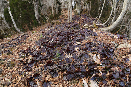
As we inch our way closer to the ridge and the Takashima Trail, we push through the virgin beech forest awestruck by its sheer beauty. Catching the trees before they lose their foliage is tricky, for the leaves turn a brilliant yellow for just a short time before becoming brown and falling to the forest floor in the steady November breezes. While the oaks and maples show off their foliage, the beech have already laid down for winter, but it sure beats tramping through a forest of monocultural cedar. Many thanks go out to the residents of Makino village for not selling their woods to the plantation lords.
The forest eventually thins as we pass directly under an electrical pylon and onto a broad ridge leading to Awagaragoe (6). A quick turn right and a short climb takes us back up to Mt Akasaka (5) and its brilliant views across Lake Biwa out to Mt Ibuki. Although the 824m peak is already in bare-branch winter mode, the bald summit offers a rare chance to look down upon the autumn foliage from above.
Ted takes the lead as we drop off the northeastern face of the pointy top, drawn to an even bigger peak by the name of Mt Mikuni sitting off to our left. According to the map, the trail does a bit of meandering under the mountain before reaching a junction for the optional climb to the summit. But first, the rock formations of Myō-ō no hage (4) deserve closer inspection.
We scramble among the sandstone boulders through a climber’s playground overlooking the gray waters of Biwa. The sandstone looks as if it’s been poached from the Minami Alps and plopped down directly on the ridge. No doubt a quarry owner or two has stared up at these rocks from below with feelings of greed and envy. After a bit of scrambling, we leave the rocks behind for the shelter and beauty of the forest floor once again.
Our track drops down to a mountain stream, a source of refreshment for thru hikers as the watering holes are few and far between out here on the Takashima. Once again we enter the dazzling world of reds and golds, meander a few serpentine curves, and reach the junction for Mikuni. We turn left here off the main trail and immediately embark on an abrupt ascent up a spine of low-lying trees to the 876m Mikuniyama (3) our high point of the day which we reach at 11:45am, a perfect place for midday nourishment.
On the descent back to the junction, the four of us stare out across a broad plateau and catch a clear view of Mt Norikura, our final peak on the Takashima. The amount of distance left to cover does nothing but make our hearts sink, as it looks like an impossibly long way off on a completely different mountain range. A mountain pass between here and there does offer a chance at an escape route, but for now we hold off on making that crucial decision.
Back at the main trail, we turn left and are now heading due east through a long stretch of wooden boardwalks leading through marshy grasslands of golden hues. Having a bit of flat to traverse is refreshing considering the contours we have just completed. This sense of ease does not last long, however, as the track reenters the thick woods along a knee-knocking descent adorned with fixed chains in some of the steeper places. It’s unfathomable that I had actually considered a winter ascent of Mikuni back in my winter hiking days—it surely would have killed me.
The altimeter drops as we lose a worrying amount of altitude as we finally reach a dirt forest road smothered with slippery leaf litter. To make matters worse, this is not even the main forest road at the pass, for the Takashima soon has us leaving this flat safe haven in favor of a more direct drop through a steep gully that could easily double as a ski run. With burning quads and laughing knees we stumble into Kurokotōge (2). A gravel road here leads down the valley to Shiratani Onsen, and as tempting as that might be, a quick glance at Ted confirms my suspicions that we are NOT coming back for another round. A wooden shelter housing a clean toilet offers us an excuse to rest. After relieving myself, I stuff as much chocolate in my mouth as I can hold, stretch my aching calves, and reach deep within my inner reserves for the strength to take us back up to the ridge high above.
Once again I offer to take the lead as we cross over the forest road and begin our long ascent skyward. I bite my lower lip and push through the tightness in my legs. The initial route through a gully soon merges with a broad spur of healthy beech trees. We step over a collection of scat, most likely ursine in nature as we push our way though the broadleaf dominion. The afternoon light sends deep shadows through the grove, illuminating the foliage like a Christmas lightshow. Such spectacles can do a lot to take your mind off the fatigue.
With spirits high, we reach the crest of a ridge and stop in our tracks, as a signpost clearly indicates that we have an agonizing 3.7km to the summit of Norikura. Not only do we have the debilitating horizontal distance to cover, a scan of the surround hills confirms our suspicions that we have a whole heck of a lot of vertical distance to cover as well. At a place on the map marked as Sarugababa, the trail makes a 90-degree turn and takes us due north up a hillock of susuki grass that terminates at a colossal electrical pylon constructed together with a small hut constructed for the benefit of Kansai electric workers.
The Takashima Trail now merges with a track built by electrical maintenance workers who want nothing more than to traverse the shortest and steepest route to their next electrical pylon along the grid. While rubber steps have been hammered into the hillside, the do nothing to ease the leg pain of weary mountaineers. At every step forward I let out an obscenity, cursing the laziness of the track builders who didn’t even have to courtesy to laid down once single switchback.
As we reach the next electrical pylon the four of us collapse in a heap of sweat and fatigue. I break out the map and realize that we have only progressed about an inch on paper. We veer left and then right, climbing a grassy knoll affording vistas northward to Tsuruga city and the Sea of Japan coast.
The views do nothing to lift our defeated spirits; nor do the sounds of weed whackers as maintenance workers can be seen trimming weeds from the next pylon on the grid sitting further up our impossibly steep ridge. Ted gives the crew the one-fingered salute along with a greeting that rhymes with Truck Foo, summarizing our mood in a nutshell.
With nothing to do but put one foot in front of the other, we march along in silence and climb hillock after hillock chasing those electrical giants.
Up and over three more hills we struggle, hoping for at least a view of Norikura to help lift us from the doldrums, but all we can see on the horizon is a collection of yet more electrical pylons. I can see why 99% of Takashima Trail hikers do this 80km in reverse: they can fly through this mess on day 1 and spend the remainder of their time in the more beautiful sections of trail further southwest. At last we reach a junction for the short side path to Ashiharadake, where we find the purple-suited weedwhackers of Kansai Electric. Ted lets out another profane greeting and rightly so.
Back to the junction and to the south we drop, finally away from the electrical mess and back into the lush beech forests. The contours also finally ease and we are blessed with a relatively flat track to follow as we finally start to gain some horizontal ground. We push through a brilliant grove of giant beech—easily the most impressive collection of trees of the day. Our trail takes us just below the true ridge and past these hardwood behemoths until…..
……depositing us on a paved—yes, you heard that right—a paved road. Bitumen, gracing the once forested slopes of Norikura. Where does this paved road lead, you might ask? Well, to a massive TV antenna of course. Oh Japan, how can you go from giving us such sheer beauty and such shocking development in a matter of minutes?
In a show of solidarity, we avoid the pavement and stick to the grassy shoulder of the broad deserted road. Just below the tower we leave the road, ascend up a collection of fixed metal ladders, and traverse past a second tower and finally back into a more comforting beech forest for the final climb to the summit of Mt Norikura (1). We have finally reached trailpoint #1 on the Trail, a journey that started back in March in northern Kyoto on trailpoint #32.
With no view to speak of, the four of us continue along the trail for just a few minutes until reaching a narrow rock outcrop directly on the trail, which seems as good a place as any for our final break. It is now 3pm and we have been on our feet for 6 hours straight. I throw Ted a Cappuccino energy gel while Yasu fires up the stove to cook noodles. Ted and I roll our eyes as we had hoped to just take a quick break instead of settling in for a second lunch. While Ted and I study the map, devour our gel, and scan the forested slopes below us for a glimpse at the location of our car, Yasu has not only cooked up a bowl of hot noodles, but has already finished eating and is packing away his stove. What we thought would occupy the better part of an hour has taken less than 5 minutes. We stretch our legs for an additional 10 minutes and let the caffeine kick in.
This final stretch of trail I vaguely remember from my first visit, and with the bear spray firmly attached to the belt of my trousers I keep my eyes peeled should the bear from my one and only encounter in Japan reappear. The scenery takes on a familiar tone as I click away, hoping to capture photos that I could not get during my first trip here. The undulating ridge shimmers in the late afternoon light as we set off toward our final descent. There is one last reunion with the electrical pylon and a steep grassy slope to navigate. About halfway down the hill my feet slip out from under me and I end up on my butt, laughing uncontrollably as the electrical workers have exacted their revenge upon us all.
Just past the pylon we leave the ridge for the final time and turn down the eastern face of the mountain. By now we are on autopilot, and with daylight waning we focus our attention on avoiding injuring ourselves on the steep terrain. While the foliage continues to impress, I can do little more than think about the final goal sitting just below us. It takes us the better part of an hour to reach the top of the ski resort, a fitting end to our Takashima dream.
Our journey is far from over, however, as we must now head straight down the top of the ski slopes through a trackless field of sandy grass. My quads scream for me to stop but I let gravity take hold, keeping my peripheral vision on high alert should the bear return. Fortunately, all is well that ends well, as our quartet reaches Arachigoe (0), the official terminus of the trail. After a congratulatory photo, it’s back to business as we reach the car and dusk and embark on the long drive home.
So, was the Takashima worth it? As a multiday hike, it does traverse through some of the best forests in Kansai. However, it would be a lot wiser and less sadistic to do this as a 4-5 day thru hike instead of doing it in sections, in reverse no less, over a series of 8 days. We did more than double the horizontal distance that a continuous thru hike would entail. Here are our stats:
Day 1: 16 km
Day 2: 21km
Day 3: 22 km
Day 4: 23 km
Day 5: 20 km
Day 6: 34 km
Day 7: 17 km
Day 8: 19 km
Total: 172 km (vs. 80km for a thru hike)
Takashima Trail – Section Hike part 7
Posted in Takashima trail, tagged Hiking in Japan, Japan, Kansai, Takashima trail on November 2, 2022| Leave a Comment »
As we edge closer to Makino and the end of our 80km section hike, Ted and I study the weather forecasts and research about the current state of the forest road to Nukedo. We are perhaps just one heavy rain away from the road being lost to landslides, so time is of the essence. Late October and the stage is set, with a high-pressure system and a rare family-free weekend providing a much-needed catalyst. Ted points the car north on route 367 before shooting northwest into Fukui Prefecture and past the port town of Obama. Further east, after skirting the edge of Mihama city, Ted navigates the impossibly twisted switchbacks above the Mimi river as we finally reach the full parking lot of Nukedo where we last left the Takashima. It seems that we are not the only ones out to take advantage of the autumn weather.
A group of school kids loiter at one of two trails leading skyward toward Ōtaniyama. The leader prepares to take them up the Mihama trail, so we scoot past and opt for the proper Takashima route running through neighboring Shiga Prefecture. We shoot off at a brisk pace, eager to reach the top of the spur ahead of the elementary-aged children. Dew glistens off the trees as we make our way up the shaded eastern slopes. The rising sun penetrates through gaps in the dense forest canopy, illuminating the brilliant autumn foliage in its seasonal amber hues.
The Takashima leads us up a narrow spur through a kingdom of healthy hardwoods. For a change of scenery, I ask Ted about his fledgling career as a part-time method actor, for which he willingly enlightens me about his time on the set of the 2009 indie film Tengu.
The world of acting is one field I have yet to explore, unless you count a pair of appearances in long-forgotten TV commercials, an obscure music video, and an awkward interview on MUSIC EDGE, so I listen with perked ears as he provides a few titillating behind-the-scenes tidbits that make us forget about the steep climb at hand. Not only do we stay ahead of the school group, we make it nearly to the edge of the summit ridge before the squawks of a large troupe of macaques interrupt our Hollywood reverie. The primates stay out of sight, preferring the shaded depths of a steep valley on our left, but cries grow fainter just as we break out of the forest onto a massive network of rolling ridges of golden grasses and low-lying shrubbery.
What a welcome sight to behold as I scream for delight like a hyperactive child at the county fair. As much as I love a hardwood forest, there’s nothing like hiking on an open ridge with expansive panoramic views. Mt Ibuki sits due east, across the Maya blue waters of Japan’s largest freshwater lake. North of Ibuki, folds of foreshortened ridges in neighboring Gifu prefecture span the horizon, while the mighty Hakusan lies hidden behind a haze of cloud. Light winds coax us along on the gentle inclines to the summit of Ōtaniyama (8), where we glimpse our first unobstructed views of Mt Akasaka sitting on the far end of the oblong ridge. A track drops off here to the south for a couple of hours to the outskirts of Makino. This is the track we were originally planning to take on Day 6 of our hike before giving in to fatigue and an easier escape route back to our car. It has taken us a little over an hour from our car in Nukedo, and with the weather on our side, we pause here for a quick mid-morning snack while savoring the views.
The track drops abruptly straight down the northwestern face of Ōtani’s bulbous edifice, through swaths of Japanese pampas grass dancing gracefully in the breeze. The bright sun sends us scrambling for the sunglasses as we drop toward a narrow col dotted with gnarled hardwoods. To our right, seemingly directly below us, we stare straight down into the sprawling campground of Makino Kogen, our intended starting point for Day 8 if our current hike goes according to plan.
Golden foliage set against the deep blue of the autumn skies sends a smile through my face. Turning around, I see the same countenance spread across Ted’s content face as we silently share our delight at being blessed with that elusive tozan byori, or perfect hiking weather. The Makino range has a bit of a reputation for foul summer weather and blustery wintry blizzards that attract only the foolhardy. Long switchbacks take us through the radiant autumnal hues of the mixed hardwoods and up to the summit of the minor peak of Kanpū (7), providing a striking contrast to the snow-smothered scenery that I had experienced during my first visit here just 8 months prior.
We take in the expansive views while soaking up the rays of the sun, our legs stretched across the small gravel strewn throughout the broad plateau. With the paper map spread between us, we find ourselves with just a 2.5km hike to our turnaround point at Awagaragoe. It seems easy on paper, but one glance to the northeast reveals that we have our work cut out for us.
Dropping steeply down the northern face of Kanpū, the track takes us through a tunnel of twisted beech and onto gentler slopes carpeted with soft grasses leading to to the top of a rise revealing a ridge of rolling slopes. Ted and I spy the summit of Mt Akasaka at the end of this roller coaster of a ridge and it looks deceptively far. Beyond, on an entirely different ridge line, lies the elongated summit of Mt Norikura, the final peak on the Takashima Trail that taunts us like a rival, waving its finger as if to prove that finishing the trail today is an impossibility. We can only hope that this stable high pressure system gives us a chance to complete our goal before the first snowfalls of winter.
While easy to follow, the route hardly takes us in a straight line, instead it opts to hug the ridge tightly as it weaves in and out between forested hillocks and grasslands fit for bovines. We passing up and over a series of unnamed summits, and with each passing peak comes the realization that we will need to re-climb all of these peaks on our return to the car. I mean, we could turn left at Awagaragoe and drop down the old Wakasa Kaidō and loop back to the car. The problem with that is that it would add an extra 10km to our already long hike and it would involve walking up the forest road back to the car. Much better to stay on the ridge, even if it means retracing our steps.
At the top of the third rise in the ridge, we run into an elderly man involved in trail maintenance work. The gentleman informs us that he works for the Takashima tourism bureau and is in charge of promoting the Takashima Trail. We tell him that we are nearly 7/8 the way through our reverse section-hike as we boast about the incredible scenery on the Kyoto section of the trail. “Oh, I haven’t been that far,” he explains rather sheepishly. That is hardly surprising, as his only concern is with bringing money to his fiefdom of Makino instead of promoting the trail as a neutral 3rd-party observer. That’s the problem with tourism agencies across Japan, who are reticent to promote areas in neighboring prefectures as they don’t receive their share of the money if tourists go there. While the Edo era is long gone, feudalism in Japan remains a stronghold in many aspects of society.
It takes us an additional 20 minutes along the pleasant ridge to reach the first of a series of unsightly electrical pylons built to transport electricity from Mihama Nuclear Power Plant to the urban cities of the Kansai region. You can’t hike far in Japan without coming across either a forest road or an electrical pylon, and the Takashima has delivered both. We pass under the monstrous towers, with their low hum providing a drone-like rhythm to our measured footfalls. It is just after nigh noon when we reach Awagaragoe (6) and the first of the crowds ascending from the popular weekend playground of Makino Kōgen. In a rocky niche above the mountain pass sits a weather-beaten carving of the three-headed Hayagriva, apparently erected there to protect the horses that were traditionally used to carry travelers up and over the mountain pass.
With absolutely no impressive view to speak of, Ted and I decide to carry on a further 500 meters to the summit of Mt Akasaka (5) for a well-deserved lunch break. Before departing for the summit, I put on my Aladdin hat in an attempt at some Halloween humor that immediately backfires among the throngs of day trippers basking in the sunshine. They probably all think that I’m wearing it as a fashion accessory and even Ted starts calling me Lawrence in homage to the Seven Pillars of Wisdom.
After lunch I ditch the costume and we start our long retreat back to the car. I guess one advantage of doing an up-and-back is that the lighting is always changing and the shadows grow deeper as the sun moves further west. We decide to push it as far as we can before taking a break, hoping to get off the mountain before dark when the nocturnal creatures awake for the evening. Indeed, the way back seems to take just a fraction of the time, with the hardest part of the climb coming as we push up the headwall just below the summit of Ōtani and run into a group of two-dozen hikers just starting their descent. On the summit, a pair of hikers don helmets and appear to be loitering on the summit for an unknown reason.
Five minutes into our descent, we discover the reason for the loitering as they set sail in their paragliding gear, swooping out above the rolling plains of Makino. Perhaps paragliding is illegal in these parts, or maybe they were just waiting for the winds to work in their favor. Either way, it is a sight to behold and provides just the change to the scenery that we are needing. As our legs turn to jelly, the rock formation sitting at the far edge of the plateau provides us the perfect place for our final break. I break out the cappuccino energy gels as Ted breaks into a fit of hysterical laughter over someone or something named cougar. We are both giddy from the exhaustion but let those waves of guffawing wash over us as we finally muster up the energy to get back on our feet and stumble the last hour back to the car. With just one final section of the Takashima remaining, we keep an eye on the weather patterns and turn to some familiar companionship to help escort us across the finish line.
Takashima Trail – Section Hike part 5
Posted in Takashima trail, tagged hiking, Hiking in Japan, Japan, Kansai, Takashima trail on July 12, 2022| Leave a Comment »
Early May and the middle of the Golden Week holiday brings Ted and I together for another rendezvous with the Takashima Trail. The next couple of sections of the trail are going to require both an immense amount of planning and an even greater exertion of energy—two of our fortes. This is our furthest drive yet, as we finally navigate the entire length of route 367 right past today’s starting point of Sakura-tōge and under route 303 to our final destination at Ishidagawa dam. We park at the dam, prepare our gear and hit the asphalt in high spirits, for we need to walk all the way back to where we last left the Takashima on route 367—or do we?
The snaking curves of the road down from the dam lead us along an idyllic section of road following the Ishida river downstream past a bustling campground. Groves of parasitic wisteria flowers flutter in the gentle breeze under the soothing sunshine of early summer. We enter a hamlet with residents busy tending to fallow fields. A flattened rat snake lays victim to an early morning vehicle. “Looks like they’ve woken up,” exclaims my companion, apprehensive of an encounter with a living reptilian foe up on the ridge.
We stroll down the road and meet route 303. The lane we drove in on cruises safely under the national highway but instinct sends us up an incline to meet the busier road. “We should be able to hitch a ride from here,” explains Ted, still riding high with confidence from our successful hitchhike during part 4 of our adventure. Sure enough, the third car to pass screeches to a halt while Ted and I scurry to put on our face masks. Just minutes later we thank our driver, shoulder the packs and enter the forest at Sakura-tōge (14). Among a grove of cedar trees nature calls, so I dig a hole and go about my business while Ted checks the GPS.
Leaving the comfort of the valley floor, Ted and I commence our ascent up a steep spur adorned with the fresh foliage of the summer canopy returning to the mountains. The sunshine sparkles off of the leaves as we push on through groves of Japanese andromeda and rhododendron buds on the verge of blossoming. Beech and oak trees guide us upward along the narrowing spur as we catch our first vistas across the valley to the Hira behemoths of Buna-ga-take and Jyatani-ga-mine. I turn to Ted and he nods at me as we stare in silence and reflect upon our winter accident on what appears to be gentle slopes from this vantage point.
After half an hour the track reaches the crest of the ridge for a roller coaster of a walk alternating between monolithic strands of planted cedar and free-wheeling colonies of beech and oak. Through one section of the former, our trail meanders around a section of typhoon debris, but those ubiquitous strands of yellow Takashima tape liberally tied to an occasional cedar usher us safely through the mess and onto a long steady slope to the summit of Mt Ni-no-tani (13). True to its name, there are two summits on the plateau, so we break for a snack on the first peak before heading over to its twin and slightly higher of the two, home to an tranquil tarn.
Though a gap in the trees, a formidable wall of green towers over us directly north. It is Buna-ga-take, our target for the afternoon and not to be confused with the other Buna-ga-take sitting directly behind us to the south. Cause for celebration is unwarranted, as the map shows us we still have over 5km of hard hiking to reach its striking summit plateau.
The loss of altitude is almost immediate after setting foot down the northeastern face and we grasp onto tree limbs to help fight against the downward pull of gravity until the angle eases abruptly and passes by a section of golden grass that looks fit for a bear encounter. The ridge narrows briefly and we meet our first hikers of the day. The first guy is wearing trail running gear and is equipped with nothing more than a 2-liter bottle of water grasped in his right hand as he passes head on in silence and makes quick work of the steep slopes we have just come down. There have been reports of ultra trail enthusiasts doing the entire 80km section in one day but I think I prefer our more leisurely pace.
After a brief climb past an unnamed peak the trail once again loses altitude suddently and guides us through a section of lush ferns to reach the paved road at Misaka-tōge (12). It is hard to believe that we have only a dozen more checkpoints until finishing the trail, but it is still going to take a few days to get there. We sit on a log and break for an early lunch in the shade in the forest of the 280-meter high pass. This is the old road before the tunnel was built through the mountain and if we turn left here and walk for an hour we could reach Kumagawa-juku on the old Saba Kaidō, but tourist post towns are not what bring us to the Shiga-Fukui prefectural border. We have a mountain to climb.
Again we play a cat-and-mouse game of cedar forest and hardwood grove as we face the longest and hardest climb on the entire Takashima Trail. As on past sections of the Takashima, the conversation turns to writing and working with copy editors, as Ted is on assignment to finish his contribution for a new guidebook with a constricting word count. It is always the nemesis of any travel writer and part of the reason I prefer the freeform nature of blogs. Our banter takes our mind off of the task at hand until the ever-steepening slope angle forces us into silence: we search for those inner reserves necessary to see us though to our goal.
Our initial target is to make it to the western peak of Mt Akaiwa without stopping but shortly before the summit we collapse in a heap of sweat and exhaustion. We need Lara again, and Ted delivers the goods. I pass along some chocolate and other nibbles as we rehydrate and stretch our legs. It turns out our decision is a wise one, as once we get back on our feet the path further steepens to enter a rock outcrop adorned with fixed ropes.
We hoist ourselves up and onto an outcrop affording spectacular vistas back over to Mt Ni-no-tani and over to route 367 where we had started our morning. Boy have we come a long way.
The foliage begins to take on an early spring hue as we breach the 700 meter mark and walk past a junction on the western summit Mt Akaiwa. Dense groves of rhododendron and andromeda shrubs line our way as the track narrows. Dollops of the pink iwakagami (fringed galax) once again line the trail. We have entered an entirely different ecosystem up here, on the edges of snow country and evidence of the harsh winters that batter these mountains is apparent. It is as if the retreating snow fields had melted just days prior as tree buds begin to sprout and put on their summer coats.
Kobus magnolia flowers flutter in the light breeze. It’s hard to believe that these same trees bloomed one month earlier at around the same altitude further south along the Takashima. As we admire the views, a solo female hiker approaches from the summit plateau and passes by. She is on her way down to Misaka-tōge and it dawns on us why the majority of hikers do the Takashima Trail from north to south in order to avoid our herculean climb of Buna.
We skirt past a small pond and onto the summit of Buna-ga-take (11). Time check: 1:38pm. It has been nearly 5 hours since we left our car at the dam but we have arrived. The undulating ridge between our vantage point and our next summit of Sanjo looks formidable. A change of plan may be necessary.
With an impressive view of snow-capped Hakusan on the horizon, Ted and I straddle the ridge with the paper map spread out between us and start calculating. If we push on to Sanjo it will be after 4pm, and a two-hour descent on rubbery legs on a long spur means that it will be well after dark when we reach the car. However, just a kilometer from Buna’s summit, on the ridge we need to walk, is an escape route down a spur that will take us directly to our car. The choice is easy.
Fueled on by the prospects of a shorter day, we dart along the ridge and duck into a truly scenic section of gnarled beech trees sculpted by the strong winds and snow that batter the ridge every winter. It feels like we have stepped into an enchanted forest and fortunately for us, we are blessed with brilliant sunshine and not the mind-altering hallucinations brought on by thick fog and tired minds.
Unsure of our escape route, Ted and I keep a close eye on the GPS but we are relieved to find a signpost in Japanese for Wasatani (ワサ谷) letting us know that we have 3.8km to go before reaching the road to the dam. I lead the way in high spirits before jumping in surprise after nearly stepping on a giant rat snake. Ted is thankful that I am the one encountering all of the slithering creatures for him, as he has a fear of the serpents.
Our majestic hardwood forest soon turns into a monocultural cedar plantation, but fortunately the descent is negotiable along a series of long switchbacks that usher us down to a gravel forest road covered mostly in fresh grass. This leads to a stream smothered in concrete dams and the eventual paved forest road above the dam. We turn right and stroll along the closed road for 10 minutes to reach the car at 3:30pm. The drive back to Kyoto is spent strategizing about how to walk the next section of the Takashima as it is easily the most remote part and will take some thinking.
With the approach of the rainy season, we both agree to take a few months off to scour trip reports and rack our brains for the best course of action.
Takashima Trail – Section Hike part 3
Posted in Takashima trail, tagged hiking, Hiking in Japan, Japan, Kansai, Kyoto, Takashima trail on May 23, 2022| Leave a Comment »
For the third week running, on the first of April no less, Ted and I find ourselves parked under the plum tree at the Family Mart in Ōhara, stocking up on provisions to not only sustain us on today’s hike, but also for the long drive up to the Oisugi settlement in the upper reaches of Kutsuki village. The previous week, we had driven the car along the forest road to the headwaters of the Adogawa, but this time we park the car across from Omiya shrine at a junction of two crossroads. Our plan is simple: take the left fork and retrace our steps to Nabekubo-tōge and continue our northern hike along the Takashima to Onyū-tōge and follow the old Saba-kaidō back to our car.

We make good time on the drive and arrive at the shrine shortly after 8am, greeted by a plum tree in full bloom. The bare ridge soars above the collection of depilated dwellings in the hamlet, some of which are in desperate need of re-thatching. Upkeep on these traditional thatched farmhouses is extremely costly, so it’s no surprise that most homeowners of limited means simply cover the thatch with a more durable corrugated metal. An informative signboard sits in front of a recently constructed restroom facility, providing yet another relief of the bowels before commencing on the long slog back to Takashima’s hidden ridge.

The hamlet remains quiet and still in the light of the early morning, with nary a soul in sight — though to the trained eye you can just about make out the eyes peering from behind drawn curtains gazing suspiciously at the two masked foreigners marching through their front yard. We reach the trailhead in about 15 minutes, drop the facemasks, and follow the brook upstream toward where we had last left the Takashima. Despite it being a week between our last visit, the trail is hard to pick up in places, but thanks to our digital aid we soon find the correct tributary and reach Nabekubo-tōge (25) about an hour after leaving the car. We turn right, initially accompanied by a dense cedar plantation on our right before the completely natural forest takes over at the top of a steep rise.

Through a gap in the trees, the adjacent folds of mountain ridges appear to be sprinkled with dandruff flakes, but upon closer inspection Ted and I let out a yelp of joy to discover that the hills are ablaze in the brilliant white petals of the mighty kobushi or Magnolia kobus. These stalwart deciduous trees feature a six-fingered glove of bright white flowers covering their upper branches. They are a sight to behold and really do give the cherry blossoms a run for their money for those lucky enough to come across them.

These signs of spring bring a welcome vitality to our walk, and at the crest of our first unmarked peak a green waymark shows a horizontal distance of just 4.8km to Onyū-tōge, our planned departure point. “We could be back at the car by noon at this rate”, exclaims Ted. The Takashima thinks otherwise.

Never judge a route by the horizontal distance to be covered — a vertical elevation profile is a much better way to access a walk. Without such vital information our hike turns into a roller coaster of a ridge walk, as it rises up and over a series of smaller peaks before dropping to a long saddle and turning into what Amber Heard’s lawyer can only describe as a ‘mega’ slog. I turn around and give Ted that all-too-familiar look indicating the start of a big climb. It won’t be the first time that expression is painted on my face on this fateful day.

Our conversation peters out to a series of grunts and profanities, mostly from my motormouth as I dig deep within my depleted energy reserves. It is best just to lower your head and work through the discomfort of the straining calf muscles as the feet struggle to continue their upward fight against gravity. The one upside to our muscular torment is that the scenery is second-to-none. Never in my wildest dream would I think that such an untouched and sprawling beech forest snuggles the Shiga-Fukui prefectural border along the central divide. Such spectacular beauty gives us the impetus to continue our forward progress. Giving up would be out of the question.

Even though our pace resembles that of an injured turtle, we somehow reach the summit of peak 803 in less time than indicated on the map. This gain in time, however, is quickly lost as we settle in for a well-deserved mid-morning snack and leisurely break. Once again, Lara comes to the rescue as Ted and I continue to expose each other to new trail nibbles. These all-natural fruit bars satiate our appetite and the caffeinated sports Yōkan helps us ward off the drowsiness caused by the 3am alarm clock. Restored vigor leads to a timely photo opp in the gap between two beech trees joined at the hips.

Our route diverges northwest briefly and drops to a tiny pond marked on the map as Okusuge, though there is nothing in the way of a signpost to indicate an official name for the nearly-dried marsh. Perhaps this area is a bit wetter in the summer season. We skirt around this depression and follow the tape marks as we change directions to the east and head upwards toward yet another unnamed peak. About two-thirds of the way up this slope we pass by an enormous horse-chestnut tree that appears to be home to a bear’s feeding platform. We don’t loiter around long to enough to check for inhabitants.

At the crest of the rise we once again teeter on the sea-saw ridge, taking in the views between gaps in the trees while the talk turns to vaccinations. Japan is about 6 months behind the rest of the world rolling out the inevitable inoculation as we place bets on which will come first, our completion of the Takashima, or our turn at the needle.

Those dark olive leaves of the diapensia plants that have been accompanying us on our journey finally show us their reproductive parts, as a series of majestic pink petals of the iwakagami flower finally begin to open. We can sense that summer is just around the corner as the rising heat of the late morning coaxes us to roll up our sleeves and make quick work of the ridge. Soon enough we spot a sign of encouragement: 700 meters to Onyū-tōge. I quicken my pace in anticipation of our arrival, only to be thwarted by the abrupt change in grade. It feels as if Ted and I are climbing up the transition of the quarter pipe of the Megaramp. Our only solace is that the vistas have really opened up behind us, revealing the Hira mountains in all of their beauty.

We enter a dry area of crumbly dirt scree sandwiched between groves of giant beech and cedar. Sweat flows freely from our temples as I once again gaze back at Ted in disbelief. If not for the proximity of the mountain pass I would surely like nothing more than to slouch down for a long break. At long last, we reach the top of yet another unnamed peak and find a sign informing us that our break point is just 100 meters to our right. We coast down to the paved road awaiting us at Onyū-tōge (24), the first asphalt crossing of the Takashima (or final crossing if you’re doing this hike in reverse). This would be an ideal place for your support team to greet you with cold drinks and a well-prepared meal but on this particular Wednesday, there is nary a soul in sight.

Instead of breaking here and heading off the trail, we discover that another pass is just a further 700 meters along the ridge, so after walking on asphalt for a few minutes we duck back into tree cover and reach Negorizaka-tōge at 11:35am, well ahead of schedule. This is the junction of the Saba-kaidō or old mackerel road, a route that fishmongers once used to deliver fresh fish to landlocked Kyoto city. We sit next to an old jizō statue and pore over the maps while chowing down on rice balls and other carb-laced delicacies. I remember this pass during my first climb of Hyakuri back in 2014 but never thought I would be sitting here 7 years later contemplating a second round with the mighty beast, but here we are.

Since it is still before noon, I propose to Ted that we should not only ascend Hyakuri this afternoon, but we should also continue along the ridge another 2-1/2km to Kijiyama-tōge, which will put us in good shape for our next stage of the trail. The only challenge with this is that we will have to retrace our steps back to Negorizaka-tōge so we can descend back to the car. Future Takashima trekkers should take note that section hiking this trail with only one automobile certainly is not the most efficient way to do the hike.

I guide Ted along this next section of path, pointing out landmarks that I remember from 7 years ago and giving plenty of warning to the steepness of the climb. With such pleasant weather we can see Hyakuri towering directly above us, which is both a blessing and a curse — for we can see what needs to be done before we can breach the fortress walls. Fixed ropes are a welcome addition as we push on through the lunch hour. We simply lower our heads as the switchbacks continue to steepen and dig deep within our inner strength as we inch toward the panoramic views of majestic summit. We surprise ourselves by popping out on top of Mt Hyakuri-ga-take (22) shortly before 12:30pm.

An elderly gentleman is settled in for a lunch break as we usher a quick greeting. He has climbed from the Fukui side of the mountain and is just as surprised to see us as we are to see him. Despite being three days into our trek, he is the first hiker we have come across, a testament to the remoteness of the Takashima trail and the difficulty of access. Instead of breaking here, Ted and I continue due north and immediately start losing altitude: the beech gives way to cedar and cypress before flattening out on an elongated ridge. We push past peak 711, vowing to have our own convenience store-inspired break on the return. The map indicates a 70 minute journey to Kijiyama-tōge (21) but we reach it in just 45 minutes and pause just long enough to snap a photo before turning around for our re-ascent of Hyakuri.

Peak 711 can not come soon enough as Ted and I settle among the rock formations on our pre-determined break point. I bust out the chocolate while Ted polishes off the afternoon tea bottle and we once again stare at the maps, wondering if we will be able to complete our hike before dark. The one advantage we have is that I know the route we need to take as it is the same descent trail I took back in 2014. After our invigorating snack, we force ourselves to our feet for the excruciating return to the summit. Three hundred vertical meters later, with burning calfs and tingly thighs, Ted and I give each other a high-five back on the top of Hyakuri and really take time to cherish the views. Time check: 2:04pm. We do in 90 minutes what most hikers would usually accomplish in well over 2 hours.

The drop off of Hyakuri is agonizing, but the fixed ropes aid in cushioning our descent. The most demoralizing part of the route is that, once you pass a junction for the Hyakuri Shindō route, you have to climb up Mt Hakuishi before dropping back to Negorizaka-tōge, but three-quarters of the way up, we discover a faint path to our right that avoids the summit and meets up with the track shortly before the pass. We would like to thank the kind animal that forged that path for us, even if it was made by the shapeshifting kitsune.

With no time to waste we immediately turn left at Negorizaka-tōge and bade farewell to the Takashima in favor of the Saba-kaidō. The route parallels a paved road and meets it briefly once, but for the most part we stay in the forest and navigate through a cluster of truly stunning Magnolia kobus trees in full bloom. The late afternoon light illuminates the petals like a spotlight on a stage actor and with no more ascents between us and the car the smiles once again return to our exhausted faces. At the bottom of the valley Ted admits that in his walk of the Saba-kaidō he somehow completely missed this section. Instead, he seems to have spent most of his time bushwhacking up a parallel valley if his memory serves him correctly. The last 20 minutes back to the car is a breeze, and with the fading light of the day we are already strategizing about stage 4 of our hike. For one, we will no longer be required to access the trail from this valley. We can now turn our attention to Aso village at the base of Kijiyama. Can we knock off the next section before Golden Week?
Takashima Trail – Section Hike part 2
Posted in Takashima trail, tagged hiking, Hiking in Japan, Japan, Kansai, Takashima trail on May 2, 2022| Leave a Comment »
It’s been exactly a week since our start on the Takashima, and here we are once again up in the bowels of northern Kutsuki. We need to ascend back to the ridge line to Iwatani-tōge, but instead of the steep spur from the previous week, Ted and I spy a forest road that will take us most of the way up towards Jizo-tōge, a further 3.8km along the ridge. Our plan? Walk up to Jizo and do a quick up-and-back along the ridge to Iwatani before continuing our northern trek to Makino.

Fortunately for us, the forest road is in decent condition, with just a few small potholes to maneuver around. We park next to the headwaters of the Adogawa river, marked by a small signpost and home to a toilet block in working order. With a water source nearby, it would be make a good place to camp for thru hikers as long as the mountain leeches are behaving themselves.

A deep cobalt sky accompanies us on the meandering walk along the dirt road towards the ridge. The bare canopy of the forest seeks the warmth of the sun as the shaded slopes cling tightly to their dusted coating of fresh snow. At Jizō-tōge (27) a gate across the road serves as the only indicator that we are standing at one of the entrances to the Ashiu forest, a protected woodlands under the jurisdiction of Kyoto University. It was in these woods that we inadvertently wandered during Day 1 of our section hike and Jizō pass serves as our entrance point for the start of today’s walk.

Our first mission is to backtrack to the east for 3.8km to Iwatani-tōge where we finished our first day. Leaving the road on our left, we climb a steep embankment that leads to a broad slope smothered with giant beech trees. To our right, one such tree plays host to an impressive collection of parasitic mistletoe clinging tightly to the silvery branches. Those looking for that festive holiday decoration just need to bring their own shotgun so they can shoot it out of the sky.

Remnants of last night’s snowfall provides a soft flooring under our shuffling feet as we enter a thick grove of rhododendron to reach an unnamed summit hosting an ancient Mongolian oak of an immense size. A depilated signpost points to the east, so we turn left here and hug the broad ridge as it guides us through an idyllic paradise of untracked hardwoods. So few are the visitors to this ridge that nary a trace remains, so we frequently consult with our digital navigation devices in hopes for a safe passage through the untamed wilderness.

The track undulates, sometimes dropping to a short saddle before gaining a few meters over a series of false summits. We have our work cut out for us on the return journey, but for now we can do nothing other than to set our sights on reaching the pass. After skirting past a partial clearing with bewitching vistas to the north, we pass over an 800m peak that the map refers to as Kabeyoshi (カベヨシ), which serves as our halfway point distance wise. An ancient Ashiu cedar tree stands guard as if to warn us that we still have quite a ways to go.

Stalwart strands of giant beech serve as loyal sentries to guide us through the wild labyrinth of virgin forest that sits on the edge of the protected lands of Ashiu. As we navigate through this forgotten terra firma, it dawns on us that we are experiencing a step back in time, to the true Japan of our ancestors, a place that many seek but seldom find. Centuries ago, most of Japan’s forests bore a striking resemblance to our current scenery, before modern industrialization led to the bureaucratic infatuation with trying to tame nature with monocultural seedling practices and the plastering of the hillsides in cement. We can do little more than walk in awe, humbled by the immense wilderness spread out before us.

Alas, one final drop brings us to Iwatani-tōge, where we perch ourselves on the exact same tree trunk as the previous week and dig into our provisions. It has taken us most of the morning to walk just 3.8km but we know the return journey would feel shorter as long as we keep moving. Thanks to the help of Ted’s traveling companion Lara we retrace our steps with renewed vigor.

Once back at Jizō-tōge, we continue north by first walking a short distance on the road back toward the car before veering left up an incredibly steep track marked with a series of tape marks affixed to the trees. The hillside looks like it would give way any minute, forcing us to work quickly up the switchbacks until gaining the ridge a short distance above our heads, where the terrain becomes a bit more forgiving. With stunning vistas to our left down to the Ashiu forests and plenty of virgin terrain spread out before us, our spirits are high as we keep our eyes on the lookout for signs of wildlife, ursine or otherwise.

The trekking poles help propel us along the ebbs and flows of the broad ridge, through yet more incredibly healthy swaths of pristine beech forest. At one broad saddle we notice a series of wildlife cameras installed to likely keep tabs on the bear population. We do a quick shuffle as we pass, knowing that some researcher will likely get a kick out of our improvised boogie brought on by the good forest vibes, spectacular weather, and sleep deprivation.

We push higher, following the contours as they lead past a track to the east that would take us directly down to the car if needed, but in these conditions it would be foolish to end our hike now. Instead, our route ushers us to an expansive depression hosting an elongated pond that is nearly dry with the lack of recent rainfall. We skirt the edge of this basin before an abrupt ascent to our left leads to the summit of Mikuni-tōge (26), where we settle in for a late lunch. My watch reads just before 2pm and we’ve made good progress considering the rugged ground we had covered. The kanji characters cause problems for many hikers, as both Sangoku and Mikuni are two different readings of the same kanji (三国).

A signboard on the summit indicates that the ridge leading west of here is off limits to those without special permission to enter, as it is within the boundaries of Ashiu forest; though I have heard stories of other hikers using this ridge as a way of linking up Hachigamine further west. It’s an enticing route, and I’m sure the researchers would be perfectly fine with you sticking to the ridge as long as you aren’t poaching wild flora or fauna.

Ted and I study the maps and spy a side track further along our route that will lead us back to the car. This should set up a more manageable Day 3 of our journey. With that in mind, we drop back down to the pond, bidding farewell to Kyoto Prefecture and continue to the northeast on a long descent to Nabekubo-tōge (25). A third of the way down the slope, a clearing on our left affords us with our first view of the twin-peaked Mt Aoba floating off the horizon to the northwest. It’s hard to believe that we are so close to the Sea of Japan, but then again, we are walking on the divide, so I suppose it does make sense.

At Nabekubo, we take leave of the Takashima for today and head down a rugged valley to the southeast. It’s a short 40-minute descent back to the paved forest road, where we turn right for the walk back to the car. With the Kyoto section of the trail now behind us, we spend the return drive back to the city in full-on planning mode, deciding that we should be able to reach Mt Hyakkuri in the next installment of our section hike.

Takashima Trail – Section Hike part 1
Posted in Takashima trail, tagged hiking, Japan, Kansai, Kyoto, Takashima trail on March 15, 2022| Leave a Comment »
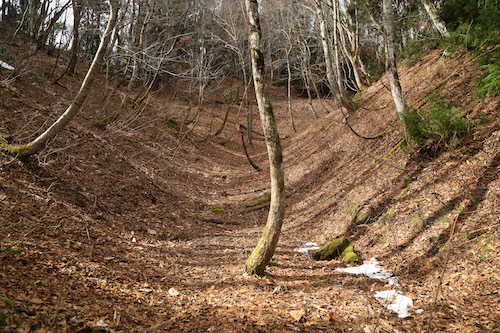
Mid-March. We can put off this endeavor no longer. The drive northward takes an hour, with an obligatory stopover at the Family Mart in Ōhara for nourishment and lavatory relief. Ted parks the car under a weeping plum tree in the convenience store parking lot and we make good use of the facilities before continuing up route 367 past the Buna-ga-take trailhead and further west on route 781 into the bowels of Kutsuki village. We park on the shoulder of the road, hop over a barrier, and stroll up a gravel forest road while studying the maps on our digital navigation devices. I signal to Ted to turn left on an incredibly steep forest road, which he reluctantly agrees—though his map indicates that following the stream is the most direct approach. We ascend to nearly the top of the spur until I zoom out on my map and realize, to my utter disbelief, that we are actually on the entirely wrong route. In our enthusiasm to hit the trail we had parked the car too early and were following a rather obscure and seldomly used track to Migo-goe (ミゴ越) on the far side of Kyo-ga-take (経ヶ岳). After some consultation, and a reflection upon our arduous track record, we both agree that a wise retreat back to the car is our best bet.

Once back at the vehicle, we indeed find the proper trailhead further along the paved road and park the car next to a farmer’s field near Kuwarabashi bridge. As we walk toward the bridge, a signpost indicates that today’s route sits along the so-called Fairy Trail, a trail-running race that will likely turn you into a fairy should you choose to brave the leeches and summer rains to participate. With the trail-running boom come more and more of these long-distance races that seem to be set up as a way to cash in on the trend. Joining these races will usually set you back at least one Fukuzawa note. If I were into trail running I would just save some money and run the race courses off season for free but I guess the idea of joining a race is to share your misery with fellow-minded sadists. Just beyond the bridge we find a large signpost for the Takashima trail and follow the first few meters of the track up into a damp forest of moss and cedar.

As we work out war up the switchbacks towards the ridge line, the conversation soon turns to self-publishing and the challenges of working with editors and the publishing industry. Since both of us are seasoned authors, with my guidebook and his walking anthology, the enthralling conversation gets our mind off the long climb, taking us up and out of the cedar plantations and onto a wild spur punctuated with the contorted limbs of the Ashiu-sugi trees dotted along the rarely trodden route.

Shrubs of rhododendron and andromeda add a green accent to the hazel tones of the forest floor as the spur gently guides us towards the towering ridge above. To our left, the slopes crescendo abruptly down a ravine choked with years of rock and tree fall, while to our right the contours fall away into Tamba valley and the sounds of a hidden stream flowing through the untouched valley. As the sun licks the trail all around us, we peel off the layers in an effort to speed the evaporation of sweat from our overheated bodies.

The route is liberally plastered with yellow tape reading Takashima Trail, affixed to the tree branches at such regular intervals that would give the Tanabata Festival in Sendai a run for its money. Don’t get me wrong — way marks are an integral part of any long-distance trail, but perhaps stringing them every five meters is a bit overkill. Just below the true ridge, our track converges with the upper reaches of Tamba valley, whose trough is dotted with patches of lingering snow. Fortunately, an unusually warm winter means that we are spared the agony of potholing through the usual thigh-deep drifts.
We reach the junction at Tanbagoe (31), the first of the 31 official Takashima trail posts lining the route. Ted and I pause here and try to imagine what life must have been like in the begone days as travelers used this route to enter Tanba province from neighboring domain of Wakasa. A tea house was erected here in centuries past to provide rest and most likely served as a checkpoint during the more turbulent times in Japan’s feudal history. A famous song, penned by the renowned Enka lyricist Ryūtarō Kinoshita, uses the Tanbagoe as the setting for a lover’s lament:
The Takashima trail heads northwest towards the first peak of Sangoku-dake, but Ted and I instead head south along the main ridge on the Shiga-Kyoto Prefectural border. The path ascends abruptly through a thicket of sprawling rhododendron to an unnamed summit, where route finding becomes a bit tricky. After a bit of a search through the overgrown brush, a careful study of the GPS coaxes us further southeast to the correct route which soon spits us out on a dirt forest road. Even the plantation overlords have made their presence known in these hidden upper depths of Kyoto. Fortunately the route soon leaves this blight and sends us up an impossibly steep slope to the summit of Kyō-ga-dake (経ヶ岳), where we pause for refreshments. A recently erected signpost proclaims that this is post #32 of the Takashima Trail. So much for the Takashima Trail terminating at Kuwahara — perhaps this is a new extension?

Instead of continuing past Kyō-ga-dake and into the unknown, we retreat back to Tambagoe junction and return to official Takashima Trail territory, where a dense network of hardwood and conifers envelop the broad ridge of wild golden grasses and withered weeds. To say these hidden heights of Kyoto are untracked would be a disservice: we are completely alone, following the contours of the land as if we are the first ones to ever set foot in this magical paradise. A clearing between lofty trees would make for the perfect filming location if not for the difficult access and lack of amenities.

Armies of great buna, or beech trees, stand guard all around us, whose bare canopies stretch out in open arms towards the cobalt sky. It is these virgin buna groves that accompany us, as passive escorts, on our 80km march to Takashima. Ted and I gaze skyward as these hardwood centenarians demand our attention and respect. Forward progress is slowed as we aim to capture with our memories what cannot be captured through film.

We follow the undulating ebbs and flows of the ridge, through swaths of iwakagami plants, an endemic species of the diapensia family that can be usually be found in abundance in the Suzuka mountains and the highlands of Gifu Prefecture. The pink flowers usually open in late spring, but for now the raisin-colored leaves wait patiently for the spring thaw and the promise of a continued perennial existence.
A junction is soon reached, signposted for the summit of Sangoku, on a side track just off the main Takashima trail to the southwest. We turn here, edging along the top of a slope of verdant fescue grass poking through gaps in the receding snowpack. It has been an unusually warm winter, and the meter-deep snowfields are nowhere to be found, giving Ted and I a sense of relief considering our previous close call.

Shortly after the lunchtime chimes, we arrive at the bear-scarred signpost on the summit of Mt Sangoku (三国岳)(29) and take a well-deserved break in the soothing sunshine. Many hikers mistake the reading of the kanji for Mikuni but the name is apt as it sits on the border of the old provinces of Tamba, Yamashiro, and Ōmi. Now it doubles as the border between Kyoto and Shiga Prefectures and a quick look at our map indicates that our outstretched feet are actually in the northernmost terminus of Sakyō-ku in Kyoto city though we are literally hours away from what would traditionally encompass the border of the city. Over the last century, many smaller villages have been absorbed by the larger metropolitan areas, and even the summit of Mt Norikura in the Japan Alps is under the jurisdiction of Takayama city, though mostly in name only.

We backtrack to the main trail and turn left, following the folds of the ridge until they become enveloped in a blanket of snow. A track to the northeast loops back to the car, so we search around for a signpost or bit of tape for the Takashima, and finally spot one as the route takes a hard left and follows an adjacent spur smothered in twisty Ashiu-sugi. A signpost dangling from its axis informs us that Iwatani-tōge, our intended target, is apparently located in hell.

Pushing forward on the spur, we come across some green netting sitting by the side of the route, apparently ready to be spread over some endangered flora. The area looks neatly manicured, as if someone has been doing a bit of upkeep. Ted and I pause to consult with the GPS as we come to the realization that we have inadvertently stumbled into Ashiu primeval forest, a protected area under the jurisdiction of Kyoto University. Special permission is required to enter the area, so rather than risk an international incident, we retreat back to the dilapidated signpost, double check the map, and make a hard right here on a narrow spur that runs perpendicular to our current position. The spur is hidden by a thick grove of rhododendron and once we push through the first few meters the route becomes clear—we must lose altitude.

And drop we do, along a precarious root-infested track with steep drops on our right. We pick our way through the contorted mess of imposing beech, cryptomeria and oak as it leads us, at last, to Iwatani-tōge (28). We pause for chocolate and study the maps. We’ve got 3.8km to go until the next pass, where a long forest road will lead us back to the car. The alternative is to leave the Takashima and drop to Hōtani and a more reasonable walk back that would save a couple of hours of walking. The choice is obvious as we bade farewell to the Takashima.

A jumbled mess of thick rhododendron groves is our reward for choosing this route. Ted and I both turn to each other about a third of the way down and agree that coming back up this route would not be fun, for it involves a fair amount of route-finding and more time glued to our GPS than to the sights of the actual trail. The sound of moving water gradually comes within earshot as we snake past a gargantuan horse chestnut clinging tightly to the steep slopes. Improvised switchbacks through a carpet of thick cedar needles lead us to the shores of an idyllic mountain stream glistening in the late afternoon sun. Who knew such pristine tracks of land existed so close to civilization?

We turn downstream and eventually meet up with the remnants of an old forest road that takes us back to route 781 and a twenty-minute stroll back to the car. After such an enthralling hike in breathtaking scenery, Ted turns to me with an enticing offer: “Shall we come back next week?”
Takashima Trail – Prologue
Posted in Takashima trail, tagged hiking, Japan, Kansai, Takashima trail on February 28, 2022| Leave a Comment »
The Takashima trail is a long-distance hiking trail in northern Kansai that serves as the watershed divide between the Sea of Japan and Pacific Ocean. The 80km trail starts in Takashima city, running along the Shiga/Fukui border for most of the way until Mikuni-tōge (三国峠), where it then follows the Shiga/Kyoto border for the final 7.2 kilometers to Sangoku-dake (三国岳) further south in Takashima city in the former village of Kuwabara in the Kutsuki district. The majority of hikers start at Kunizakai ski resort and work their way southwest to Kutsuki, a route that generally takes 5 days to complete. Water sources are few and far between, making logistics a nightmare. With this in mind, Ted and I conjure up a plan to section hike the entire trail in reverse, starting in Kutsuki and working our way northeast to Kunizakai.

Can we make it before the start of the winter snows? Stay tuned.
Mt. Omine Chapter 5 – Peak Hunters
Posted in Kansai hikes, tagged Hiking in Japan, Hyakumeizan, Japan, Kansai, Nara, Omine on September 9, 2021| 1 Comment »
Alastair and I navigate the fog-smothered switchbacks of the Odaigahara Driveway in the pre-dawn darkness, a stillness in the rent-a-car as my thoughts drift, along with my drowsiness, to the impending climb up to Kansai’s highest mountain. My last trip here back in 2004 was under clear autumn skies and precisely 14 years later we find ourselves blessed with similar conditions as Alastair pulls the vehicle into one of the last remaining spaces at the western entrance to Gyojagaeri tunnel. Despite the 6am arrival time, it appears that most of the day trippers have opted for an even earlier start as we shoulder our packs in the frosty breeze.

The path ascends gently past a concrete dam, following a gurgling brook upstream to a wooden footbridge spanning the frigid waters. Crossing over, the gradient immediately steepens as the route follows a root-infested spur under an ochre canopy just beginning to catch the first few rays of the rising sun. We make good work of the ridge, spurred on by the promise of a clear day and brilliant foliage. Our rucksacks are stuffed with just enough nourishment and fluids to see us through the 1000 meters of elevation gain to the summit, and the first gusts of wind from above bring a distinctively late-autumn vibe to the air.

Alastair leads a steady pace to the ridge junction, where we merge with the main track of the Okugake-michi, the ancient pilgrimage route connecting Hongu in the south with Yoshino in the north. I am back in familiar ground but the 14 year lapse between visits does little to jog my memory, for the leaves have already left the comfort of their canopies to rest of the forest floor for the remainder of the year. Temperatures must be below average this year if the mountains are already bracing for the winter snows.

A gentle incline through a mess of toppled trees leads us to the summit of Benten-no-mori, named after the Japanese goddess of music. As if on cue, the unmistakable sound of a horagai conch shell pierces the silence as we gaze our heads upwards to the formidable wall of Mt Misen rising directly in front of us. Though we cannot see the gyōja aesthetic, we certainly feel his presence as he announces his arrival at a prayer site. A veil of swift-moving cloud holds the ridge in its grasp, threatening to rob us of a view as we descend to the saddle and hut foundation remnants at Shōbō-no-shuku. A life-size statue of Shugendo founder En No Gyōja is perched on a rock formation, lathered with wooden votive sticks below the geta sandals attached to his feet. Most hikers rest here, preparing themselves for the steep 400-vertical-meter climb to the summit of Misen, so as I motion to Alastair for a break I notice to my sheer surprise that he has already taken off at breakneck speed toward the summit.

Alas, the spellbinding power of the Hyakumeizan. So many people get caught up in the peak hunting lifestyle that they rarely pause to take in the scenery. Here I am, a decade removed from my own climbing of the 100 venerable mountains, and I find the pursuit both inspiring and partly disgusting. Over 90% of the hikers are here with the same purpose: to climb one man’s subjective mountain list that was created over 50 years ago. Now don’t get me wrong – the Ōmine mountains are an incredibly beautiful and haunting place, and Fukada’s inclusion of the range is well-warranted. However, I feel that these mountains are much better appreciated slowly, like a well-crafted French course at a Michelin-starred restaurant. In fact, I come to the realization that this is my very first, and could very well be my last, day trip in these mountains, and the other 4 Chapters of this saga were done as overnight pursuits.

Rather than chasing after the peak hunter, I keep him within eyesight, content with letting him navigate the switchbacks in front while chatting with a solo male hiker who is also bagging this peak. I explain that I have already finished the Hyakumeizan and am nearly helping my friend achieve the same self-serving goal. Luckily I am not the only one to feel the fatigue and Alastair’s pace slows to a crawl in direct proportion to the rise in the gradient. We reach the first of the hundreds of wooden steps built into the hillside as I put aside my hunger, lethargy, and fatigue and simply lower my head and count steps. I let my footfalls slow in accordance with my breathing and enter that hiking trance that has sustained me through so many hikes in Japan’s deceptively tricky mountains.

At the top of the summit ridge we turn right, ignoring a rock outcropping on our left that is now covered in fog and several steps ahead we can make out the roofline of Misen hut. A few dozen hikers loiter about the hut, most of them standing and waiting for the drifting cloud to part. Finally, Alastair agrees to a short break as I collapse onto a bench and stuff as much caffeine into my body as will allow. I explain that we’ll have a steep drop to a saddle, followed by an even steeper climb to the top of Hakkyō. After the caffeine kicks in, I lead my hiking companion up to Misen shrine, which offers a birds-eye view across the saddle to the summit piercing the sky like an A-frame building.

The path to the summit starts next to the hut, marked by a stone pillar reading Hakken (八剣山), which confuses more than a few hikers looking for the path to Hakkyō. The former name pays homage to a series of eight craggy spires along the Okugake-michi, with Hakkyō being the highest and most prominent of those peaks. The heavily-eroded track leads us to a narrow saddle with steep drops on our right, followed by an abrupt ascent through a series of gates erected to keep deer from eating the endangered Ōyamarenge (Siebold’s magnolia) shrubs. Patches of melting snow line the shaded face of the peak, a reminder winter does indeed commence in early November in this highland range. We regain the summit ridge just below the high point, with dizzying crags to the east offering a quick end to those whose footing is less than secure. A quick rock scramble is all that separates us from the top, so I take a deep breath and make that final push.

Two dozen peak hunters litter the summit, all jostling their way to the summit signpost for a proof photo. It amazes me how many people need to show proof to others that they have summited. Too many people nowadays are climbing the Hyakumeizan in order to increase their social media presence, which seems like the entirely wrong way to go about it. Peak hunting is an entirely selfish and self-serving purpose, and I have to admit back in my younger days, climbing these mountains took precedence over more important people in my life. Alastair and I retreat to a quieter rock outcropping and wait for a break in the clouds and crowds.

Ten minutes later, we have the entire summit to ourselves, reveling in the sunshine and relatively splendid views between breaks in the fog. Perhaps there is a reason to Alastair’s madness after all – push on at a breakneck pace so you can really relish the summit experience. Between bites of refreshments we snap photos and talk meizan – Hakkyō is Alastair’s 74th mountain, so I quiz him on the remaining peaks and offer a few tips. Those who attempt the 100 peaks usually find themselves inadvertently saving the toughest mountains for last. Indulged as we are in the deep mountain talk, we hardly notice a solo hiker emerge onto the summit through the rising cloud. “Haru”, I ask, unsure if we have indeed summited before her. “Yes”, she replies with her beaming Tohoku smile. Alastair and I congratulate her on reaching peak #83 in her question to climb the 100. “Shall we descend together?”, I inquire, hoping to add a little flavor to our descent back to the car. “Lead the way”, she quips.

Haru, Alastair and I spend the next two hours retracing our steps off the steep slopes of Misen and back to the parking lot at Gyojagaeri tunnel. It is in these relaxed post-summit walks that you can truly appreciate the beauty of the mountains that you give second thoughts to on the approach. Usually in climbs we are too busy inching our way up the slopes with our heads down, gasping for breath and summoning up those extra energy reserves from deep within. As we navigate the undulating folds of the broad ridge, I gaze to the southeast and notice the midday light reflecting off the golden waters of the Pacific in Mie Prefecture, while to my left the skyscrapers of Osaka city peek out from behind the slopes of Yamato-Katsuragi in northern Nara Prefecture. Only in these dizzying heights of the Kii Peninsula can you truly take in the scale of the place. Perhaps Hakkyō is worthy of a more thorough overnight inspection, and I know who to turn to for such an endeavor: a non-peak hunter.

Mt Korenge – the final peak
Posted in Kita Alps day hikes, tagged hiking, Hyakumeizan, Japan, Kita Alps on August 9, 2021| 1 Comment »
The hardest part about planning a trip to the Kita Alps is finding a clear weather window in Japan’s notoriously fickle summer weather. The second hardest part of trip planning is figuring out a schedule that works for a trio of participants, all of whom are in various stages of the COVID vaccination process. With the Olympics in full swing and COVID-19 infections on an upward trajectory, we set our eyes on July 30th as our target date for an ascent of Niigata’s highest peak, my final summit of what I have dubbed the ‘Japan 47’ – the highest mountain in each of Japan’s 47 Prefectures.

Paul picks me up at Shinano-Omachi station shortly before noon on Wednesday the 28th. The train journey northward takes most of the morning, involving transfers at both Nagoya and Matsumoto stations. Due to the pandemic, the trains are running at a fraction of capacity, with many business commuters curtailing their business trips in favor of online meetings and their own private transport. The mask stays on for the duration of the ride – I’ve grown so accustomed to wearing the protective fabric that even naps are a pleasant affair. In the past, I had always avoided wearing masks as it made me feel as if I was suffocating, but now I hardly notice the minor inconvenience.

After hitting a supermarket for lunchtime snacks, Paul guides his vehicle along the narrow curves of route 325 behind Kashimayari ski resort. At a broad clearing near the top of the lifts, a juvenile kamoshika serow crosses the lane in front of the car, nonplussed by our intrusion as the creature climbs the adjacent forested slopes in search of nourishment. We reach the end of the road and a wave of nostalgia hits, as this is where Fumito and I camped back in June of 2007 during our ascent of Mt Kashimayari. In fact, it is up this same Akaiwa spur route that I now show to Paul. Conditions are exactly as I remember them, with a concrete tunnel built under the dam at the start of the long route. The afternoon heat slows our progress as we ascend the incredibly steep spur towards Takachihodai. Due to our late start, it will be impossible to ascend Kashimayari this time around, but we make good work of the track and give up around after reaching an altitude of around 1700 meters, still 1000 meters shy of Niigata’s highest peak but it is the highest altitude I have climbed in 2021 so far, so every little bit helps.
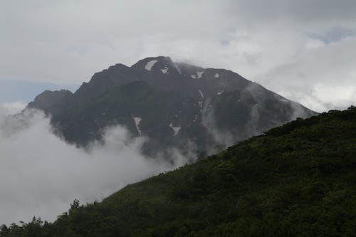
The following morning dawns clear, so I walk out in front of Paul’s house to a clearing where I stare up at Mt Hakuba-norikura shining bright in the morning sun. These clear morning views are usually short-lived in the summer, with the usual fog and rain clouds moving in for the remainder of the day. After breakfast, Paul and I head up to Kurobishi-daira near the top of Happo ski resort for a quick ascent to Happo Ike before heading down to Hakuba to pick up our friend Naresh. Thick fog and light rain await us as we reach the parking lot, and after a quick assessment, the two of us decide to continue with our plan, knowing we can turn around should the rain showers worsen. Forgoing the ski lifts, Paul leads me up a gravel road through the ski fields until reaching what he has christened “the concrete slope of death”, as the road suddenly turns to paved concrete and ascends directly up the steepest part of the ski slope. We make good time by cutting our own switchbacks through the no-nonsense approach. Halfway up we cross paths with a solo hiker making an unsteady descent down the path which forces me to grimace, knowing our same fate awaits us just a couple of hours later.

At the top of the slope we enter a verdant marshland lined with nikkōkisuge lillies and other colorful wildflowers standing out through the monochromatic backdrop of thick fog. The rain has stopped, giving us hope that what remains above may be a little more promising. At the top of the final ski lift the proper hiking track begins and we run into our first sneakered day trippers of the morning. Most of them are working their way down through the mist. With several paths to choose from, we opt for the lower track, which skirts just below the main ridge past a lingering snowfield on broad wooden boardwalks helping to aid in the ascent. All of a sudden, the fog lifts, revealing a mouthwatering vista of Mt Goryu that sends our hearts racing with excitement. We push on, with the cloud eventually catching up to us as we reach the shores of the pond. Lingering for a few minutes in heightened anticipation, the views gradually open up, revealing brilliant skies of azure hovering above Hakuba-yari. While the remainder of the Hakuba sanzan lay enveloped in cloud, Paul and I are content with just getting a glimpse of the fantastic scenery awarded to those that choose to ascent the ridge leading to Mt Karamatsu. We push on a little higher, reaching an altitude of around 2100 meters – a great acclimatization exercise for the following day’s planned ascent of Mt Korenge.

After picking up Naresh at the station, we head off for lunch and to plan the logistics of our impending climb. With several options to choose from, we decide that sleeping at a park near Hiraiwa onsen affords our best chance of making it to Renge Onsen in time to ascend Korenge for the sunrise. This entails an early start, so after packing and resting at Paul’s house, we eat a quick dinner and head to the hot spring for a quick bath before laying our sleeping bags in the sheltered comforts of the public toilet complex at the end of a quiet road. All is calm as we close our eyes around 8pm, and with the alarm set for 12:45am, we attempt to catch some shut eye. Around 40 minutes later, a rumble in the distance grows louder as it appears that a very large lorry is headed directly for our campsite. A large spotlight shines towards us as the noise crescendos and skirts past our front door. In our rush to catch some sleep we have failed to realize that our meager accommodation sits just meters from the train tracks of the JR Oito line, and our intruder is non other than the infrequent train carriage shuttling passengers to Minami-Otari. Two more trains pass by during the evening, robbing us of a good night’s sleep but still – the show must go on.

We are on the road at 1am as Paul guides his vehicle up the deserted road under the cover of darkness. Our first signs of wildlife suddenly appear, as a wild boar ducks for cover on the grassy slopes while further along, we come face to face with a massive buck who simply stares at us from frightened eyes on the shoulder of the narrow road. Shortly before 2am we park, unload the gear, and set off on our journey towards the alpine. I take the lead, setting a gradual but steady pace past some strong sulfuric fumes wafting from somewhere above. The famed outdoor baths of Renge Onsen sit off in a clearing on our left, and while the appeal of a soothing bath is hard to pass up, we all silently agree that these things are best enjoyed after a hard day on the slopes, so we push on with anticipation.

Our route is lined with a multitude of switchbacks through a healthy forest of hardwoods, and as we reach a clearing we turn off the headlamps and enjoy the moonlit views of Mt Asahi and Mt Yukikura sitting elegantly under calm and starlit skies. Winds are calm, almost unnaturally so, teasing us into thinking that this high-pressure system is sticking around for the long haul. Sweat trickles down my brow as I focus on the rhythm of my footsteps – with such a large vertical elevation change, it’s all you can do to keep your mind off of how much further you have to go. Signposts are affixed at around every 200 vertical meters of elevation gain, and by the time we reach the Tengu’s garden just above 2000 meters in elevation, the eastern horizon hints that dawn will soon be upon us. We still have roughly 3km to go before reaching the tree line, and along the uneven boulders of the rough track, progress is slow but steady. In a race against the rising sun, the luxury of taking breaks has been shelved in favor of maintaining our steady progress. The clink of metal against the rock diverts my attention, and as I turn around I witness Naresh snap his trekking pole in two in an attempt to dislodge it between two stubborn boulders.

We with realization that our race with the sunrise is in jeopardy, I give permission for Paul to push ahead while Naresh and I hold up the rear. Paul wants to gaze at the first light of the new day from as high on the ridge as he can, while the two of us will be happy with ushering in the dawn by the shores of Hakuba-Oike pond. The track skirts the edge of a Erman’s birch forest before giving away to creeping pine and vast swaths of wildflowers carpeting both sides of the trail like a floral arrangement at a bridal fair. The red roof of Shirane-oike hut comes into view, together with the calm waters of the oval tarn. The sun remains hidden behind a thin layer of cloud on the horizon, giving us the upper hand. Naresh takes one look at me and pushes on ahead and for good reason: the higher we climb above the lake the better the vantage point of the rising sun.

It’s amazing how your body can adapt to the lack of sleep and relentless gains in altitude. We’ve been on our feet for nearly three hours and have not paused more than a few seconds to catch our breath, but I feel no fatigue nor drowsiness: it is as if sheer beauty of nature serves as my energy source. At the top of the rise, around an elevation of 2500 vertical meters, Naresh and I find what we are looking for: a small clearing of fist-sized stones which make for the perfect perch for our first break of the day. We have just minutes to spare before the first rays of light reach our face. What better way to celebrate than to break out my stash of chocolate covered coffee beans.

The temperature hovers around 15 degrees in stark contrast to the 30-degree temperatures a couple of thousand vertical meters below us. As the sun makes an appearance, we turn westward, mesmerized at the alpenglow hitting Mt Yukikura and Mt Asahi. Southwest of us, further above the undulating ridge, Mt Korenge sits in a thick swath of morning cloud. Is Paul sitting up in that cloud robbed of a view?

The path meanders past a series of large cairns and up into the true alpine zone, with a plethora of wildflowers, rock ptarmigan, and ever-expanding views to keep the mind off the sleep deprivation. Naresh takes up the rear, soaking in the scenery as I gaze skywards towards the cloud bank still clinging tightly to the summit. At the top of the rise, we reach the summit of Funakoshi-no-kashira and are awarded with our first clear vista of the Daisekkei along with the rest of the Ura-Tateyama mountain range lined up in succession. Stubborn cloud hovers around Mt Kashimayari and Mt Goryu, robbing us of a clear summit profile but our current vantage point demands our undivided attention. Naresh and I pause, taking it all in.

Descending to a saddle, with dizzying drops on our left down to the Ukijima wetlands, we follow the undulating contours of the ridge as it chauffeurs us up and over a series of false summits. I call out Paul’s name just before the crest of each rise before realizing in a dejected sigh that there is still quite some distance to go. Pushed on by an unseen force, the drive to summit Niigata’s highest peak, I continue, footfall by steady footfall, until I glimpse the fog-tinged silhouette of a dozen hikers standing on the true summit as the realization of my impending accomplishment starts to weigh on my emotions. Twenty years has this long journey taken me, not only up the Nihon Hyakumeizan but beyond, to the corner of every prefecture in this geographically diverse archipelago as I attempt to accomplish what no other foreigner, alive or dead, has ever done. My eyes moisten at the thought, but I fight back the tears and take my final steps with a smile instead.

Upon reaching the summit, a round of applause emanates from the other hikers as Paul offers his congratulations. As we set up for celebratory photos, the clouds suddenly part for the first time that fateful morning, leading to an improvised chorus of oohs and ahhs from our mountain spectators. I break out the banner my father-in-law made for me and snap a few photos in the unexpected sunlight. My watch reveals that it is just past 6:30 in the morning, the climb having taken us around four-and-a-half hours. We rest of the summit and enjoy a snack while Paul tries to coax me to continue my hike by summiting Mt Shirouma. Naresh has never climbed that peak but I am not interested in climbing it as the summit is still covered in fog. Plus, I have done what I set out to do, and there’s no reason to risk altitude sickness or a turned ankle by overstaying my welcome. Paul passes me the car keys while I sit on the summit, watching my hiking companions as they disappear toward the enveloping cloud.

With the highest mountain in each of Japan’s 47 prefectures now successfully climbed, I can now announce my retirement from peak bagging. While chasing mountain summits has been a lot of fun, I will no longer let my hiking destinations be determined by a list of arbitrary mountains. From now on, I will make my decisions based on my own criteria, which will mainly involve climbing peaks that look interesting, that lie further off the beaten path, and have not been included on anyone’s subjective list of ‘famous’ mountains. Stay tuned as I continue my travels deeper into the unexplored innards of this amazing country.

