Feeds:
Posts
Comments

Archive for December, 2015

The Diamond Trail is a 45km-long path running along the mountain range separating Nara, Osaka and Wakayama Prefectures. The hiking path was established in 1969 as a joint effort between the prefectures in order to protect the forested areas of the popular peaks of Katsuragi, Kongo and Iwawaki. Unfortunately, this protective agreement came decades too late, as over 90% of the range has been clear-cut and replaced with monocultural cedar forests. Despite this devastating setback, I have had my eye on this so-called long trail for quite a while now, and with the Kansai Hyakumeizan now safely behind me, it is time to undertake the challenge.

IMG_7431

Due to the short distance, the entire trail can be done in two very long days, or if you’re superhuman like Michal, in one fell marathon swoop. I, on the other hand, amlooking to section hike the entire route, breaking it up into easier-to-swallow niblets that can be done as half-day excursions from my Osaka base. I set forth on a relatively balmy day in early February for the first section between Kamitaishi and Nijo.

IMG_7475

Alighting at Kaminotaishi station, I follow route 703 as it runs parallel to the tracks of the Kintetsu Minami-Osaka line. It takes the better part of 45 minutes along the clogged rural route before I reach the starting point of the Diamond Trail, at a geological anomaly otherwise known as Donzurubō. Formed by an ancient eruption of Mt. Nijō several millennia ago, the soft sandstone of the rocky outcrops is being eroded away by time, leaving an impressive collection of crafted natural sculptures that afford hours of rock hopping pleasure. I could easily spend the entire day here, but knew the task at hand can not be put off any longer.

IMG_7514

I retrace my steps back down route 703 until finding a junction for the roughly 3km tramp to Mt. Nijō, the first of the Diamond Trail’s five major peaks. The path rises gently at first until reaching the ridge line, where a series of wooden steps flow up and down along the contours like a rowboat bobbing in a turbulent sea. At the top of the first rise, I gasp for air in the unexpected workout. With each subsequent rise and fall of the path, I grow more weary with fatigue. The stress from the impending birth of my first child has worn down my stamina and strength. I pause on a wooden bench under an electrical tower to catch my breath and refuel with some chocolate-covered almonds.

IMG_7517

Eventually the maze of stairs subsides somewhat as I inch closer to my target. I reach a junction just below the saddle between Nijō’s twin-breasted peaks, and am alarmed to find that the Diamond Trail does not actually hit the summit of either peak. Instead, it skirts the southern edge of the female peak (like other twins in Japan, the peaks are delineated as male and female by their kanji characters) until arriving at Iwaya, a secluded grotto once lined with buddhist statues carved out of stone. All that remains now is a weather-beaten stupa and the niches that once held the sculptures that are probably collecting dust in the back room of the Nara National Museum.

IMG_7541

From here, the trail continues onwards towards Mt. Katsuragi, but I am running out of both motivation and daylight. I turn my back on the trail, opting to climb both of Nijō’s identical peaks before descending to Nijō shrine and its accompanying train station. The female summit affords mesmerizing views into the Nara plains, but the late winter haze obscures the vistas and turns the air into a muted wall of yellow.

IMG_7581

With the first section of the Diamond Trail now complete, I hope to carve out the next section of the route between Nijō and Katsuragi before the onset of summer.

Diamond Trail – Section Hike part 2

Read Full Post »

There has been plenty written about the other Sanjo in the Omine mountains of Nara Prefecture, but information about another peak by the same name remains spotty at best. It was time for my own in-depth investigation.

IMG_6399

Mt. Sanjo sits buried among a deep fold of mountains in northwestern Shiga Prefecture. It is best known as the highest point of the Takashima trail, a 80-km traverse along Japan’s Central Divide. Water down the western slopes of the mountains flows out to the Sea of Japan, while the watersheds on the eastern flanks empty out into Lake Biwa, which continues south to Osaka Bay and the Pacific Ocean.

IMG_6460

Willie and I had been planning on exploring the area in May, but just days before our departure a solo hiker was attacked by a black bear along our very route. The attack occurred at 4:30 in the afternoon along a stretch of trail that does not see many other hikers, even on the weekends. The prefectural authorities were likely to close the trail until the ursine culprit could be apprehended, so we concentrated our efforts on other mountains in the meantime.

IMG_6450

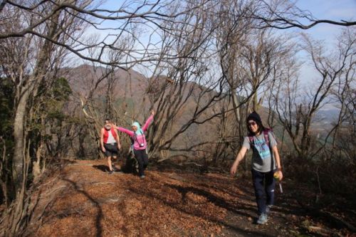
With the winter weather slowly closing in, we found another window in early December for another attempt at the monster. Will and Mai picked me up from Yamashina station at a quarter past 8 in the morning, and we headed north along the western edge of Lake Biwa and past the shuttered ski resort of Mt. Hakodate. A meandering forest road worked its way up the steep slopes, past a troupe of monkeys who seemed more interested in collecting chestnuts than checking out the vehicular intruder. At the top of the ski resort, the road eased down into a narrow valley following the Ishida river, where the trailhead for our target peak sat between two forks in the clear-running stream. We parked the car and geared up for the 4.2km slog to the summit.

IMG_6474

A flyer posted at the trailhead (and dated May 2015) warning of bear encounters suggested that hikers bring both a bear bell and spray, and avoid hiking alone. Two out of three wasn’t bad, we thought, as Mai affixed the improvised wind chime to a sidestrap on her pack. The trail wasted no time in gaining altitude, cutting through a cedar forest with little regard to the lay of the land. It was as if the original trailblazer was under a spell by the Pied Piper being led up that steep hill by a magic lute and a trail of deer droppings. Sweat oozed from the pores during the unexpected workout, making me regret my choice of insulated fleece-lined hiking pants.

IMG_6452

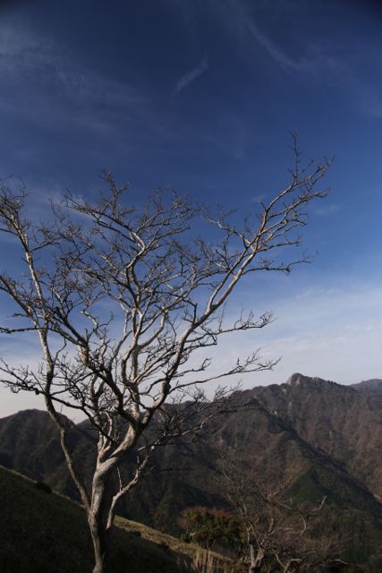
Luckily, there was only a 200-meter elevation change before the path flattened out at the ridge, and soon enough we were sitting on the spine of the mountain, admiring the vistas across the valley to Mt. Buna (not to be confused with the Mt. Buna in the Hira mountains). The cedar trees ceded their power to the mighty beech towers, whose bare limbs had long since shed their cloak of flaxen foliage.

IMG_6492

Instead of the undulating up-and-down of most ridge lines, the route was one long, gentle incline, like a wheelchair ramp for a disabled giant. Hints of animal activity lay all around: claw marks notched in the trees from the feet of a climbing bear, tree trunks stripped of bark by hungry, foraging deer, and the scat of an unknown variety laying gently among the dampened leaf litter. On this overcast day, however, the mountains were eerily quiet – not even the usual calls of songbirds could be heard in the cool, silent air. Or perhaps the drone of Mai’s bear bell and our audible cackles of laughter sent the local fauna scurrying back to their hiding places.

IMG_6514

We took our first break of the morning at the base of a towering beech whose branches fanned out above us  as if to provide a natural parasol. Indeed, this sprawling canopy must offer refreshing shade in the sunnier, greener months. I reached into my pack for an energy bar and a refill of water. As soon as I sat down, I could feel the cool air seeping into my base layer that was already damp with sweat. I put back on the fleece for the time being in an effort to prevent all of my precious body heat from escaping.

IMG_6529

A bit further up the elongated ridge, we got our first glimpse of the summit plateau rising gently in front of us. It still looked a long way off, but my GPS indicated a modest 200 meters of vertical elevation left in the climb, meaning that the worst was behind us. The trail moved through the hardwood forests dotted with grasslands stained gold from the early frosts of winter. Snow had blanketed these highlands during a recent cold spell the previous week, reminding us that the hiking window would soon be closed in these forgotten tufts.

IMG_6522

We attained the summit plateau shortly past noon, reaching a junction for a shorter trail that dropped off the eastern spur of the forested massif. It was an alternative way off the peak, as was an unmarked trail on a ridge running parallel to our approach. We opted for the latter, knowing we could always retrace our steps if the junction was not easily discernible. Lunch was devoured on the broad, open summit. I indulged in a thermos of piping-hot vegetable soup I had prepared earlier that morning, while Will and Mai dined on lunch boxes warmed by kairo heating packs affixed to the bottom of their lunch containers. I made a mental note to remember that innovative solution to a hot lunch on the cool mountains.

IMG_6557

The frigid gusts of wind blowing from Wakasa bay to the north had us reaching for extra layers. My winter down jacket was more than sufficient in the subzero temperatures. Mai jumped around eagerly to keep the blood pumping, and after a quick summit proof using a tree as an improvised tripod, we meandered along a section of the Takashima trail that whet our appetite for further exploration. The entire 80-km route looks like a fine multi-day outing – the route is anything but technical, but still offers formidable challenges due to the lack of reliable water sources along the route.

IMG_6580

After a 15-minute jaunt through the pristine grasslands, we reached a junction marked for Hachioji valley. Despite not being marked on our maps, Will possessed a printed copy of a GPS log uploaded to yamareco that showing a possible loop track back to the car. The signpost was hand-written and indicated that the trail was for ‘experts only’. I’m not sure what constitutes an ‘expert’, but, as Hyakumeizan alumni, we considered ourselves aptly qualified for the challenge.

IMG_6598

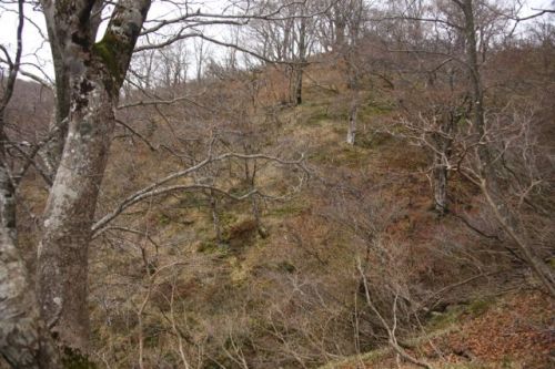
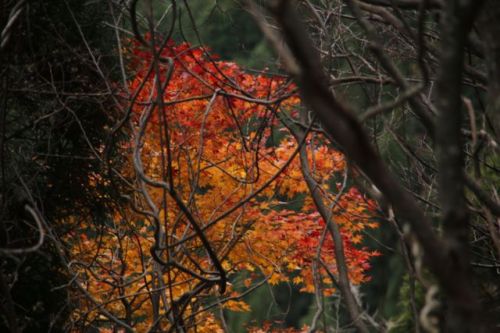
The path dropped steeply off the summit plateau before leveling off through yet another immense and incredibly beautiful virgin forest. The route narrowed in places, tramping through a thicket of rhododendron who were obviously confused by the relatively balmy temperatures for this time of year. One plant in particular had skipped winter altogether and decided to blossom five months early.

IMG_6622

After reaching an area signposted as ‘peak 686’, we stopped for a bit of a rest and rightfully so – my map indicated a significant drop in altitude to the forest road in the valley far below. Will and I split a package of fudge brownies for an extra bit of kick. The trail dropped back to the edge of a cedar forest, where it petered out all together. With the printed GPS track in hand, we veered left towards the deciduous cover, following a faint trail likely carved out by foraging deer. The pitch of the terrain was inversely proportional to our confidence level, climaxing as we reached the start of an impossibly steep gully flanked on either end by a rocky precipice. The only way down was through this gulch carpeted with leaf litter and fallen timber.

IMG_6654

Will and Mai looked at me as if I was leading them on a death march and rightfully so – one slip here and you’d tumble head-over-heel into the river churning a hundred vertical meters beneath our feet. I took the lead, lowering myself to the start of the trench one cautious step after another. At the far end of the channel, about 50 meters directly under our flailing feet, sat a natural dam of broken tree limbs and rockfall. It was hard to see what lie beyond that natural barricade, but my gut instinct was that the angle would ease a bit. Once I reached this ledge, I stepped to the side out of the path of potential rockfall and verbally guided Mai down the treacherous coulee. She made it down without too many problems, but Will looked spooked by the angle and footing.

IMG_6647

“Here, catch my pack,” he shouted, sending his 30-liter knapsack tumbling down the culvert until it somehow halted its forward progress at the base of Mai’s feet. Vertiginous though it was, it was no harder than some of the Hyakumeizan that we had scaled in the past. (though for the record, the steep trails of the more famous peaks of Japan are graciously lined with fixed rope to aid in the descents).

IMG_6668

Just as predicted, the angle did ease on the far side of the dam, with plenty of trees to help slow the momentum. Once we reached the water’s edge, a path became more apparent, though it was likely not a trail that was made by humans, as evidenced by the pellets of deer scat lining the route. At last, we spotted the forest road where we had parked our vehicle a mere 5 hours before. All that remained was to cross to the other side of the mountain stream, which Mai and I did with relative ease. Will, on the other hand, still sporting a case of the ‘laughing knees’, stepped straight off the first foothold and landed feet first into the chilly waters. Though silent he was, the expression on his face was all that needed to be said. I suspect that he’d likely have a word or two for the author of that GPS log.

IMG_6609

Once back at the road, we had a thirty minute stroll back to the car, where we changed our clothes and pointed the engine back towards Kyoto. Mt. Sanjo was a deceptively tricky mountain, but the beauty of the forest and lack of visitors (both human and ursine), made it one of the best peaks in Kansai to date. The rest of the Takashima trail will have to wait for another day.

Read Full Post »

The Gathering IV

After the success of last year’s annual gathering, I started off 2015 in great anticipation for another epic summit of like-minded mountaineers scattered throughout this mountainous island nation. However, I became bit sidetracked with the birth of my daughter and our relocation to a new apartment within the city. Still, the show must go on, and if I put it off any longer than the year end would overtake us. After a few messages with my core co-organizers, we nailed down both a location and a date for our annual mountain retreat – the national holiday weekend in late November in the Suzuka Mountains of Mie Prefecture.

IMG_6146

I set off on an early morning train on Saturday November 21st bound for Nagoya under clear skies and relatively balmy conditions. The Kintetsu line then shuffled me out of Aichi and into the factory-lined outskirts of Yokkaichi station, where a small branch line lead to Yunoyama onsen, the starting point for the rock climbing mecca of Mt. Gozaisho. Faced with an 8km walk to the campsite from here, I opted for the quicker option of hailing a cab. My driver was a jovial elderly transplant from Osaka who showed off the local sites en route to Miyazuma campground. The taxi shirted the edge of a a Jack Nicklaus signature golf course before traversing past a small reservoir and prefectural industrial research park. After forking over the fare, which came to the equivalent of a night out in Osaka, I strolled down to the campground, where Grace the Yamaholic was waiting patiently with her young niece and nephew. Standing beside her, a beaming gentleman draped in cycling gear and sporting a substantial mound of facial hair stood watch. He introduced himself as Art, an adventurous fellow who had cycled here over the last several days from Osaka. The gathering had officially begun.

IMG_6147

Dewi, our resident Indonesian super hiker soon diverged upon camp, escorted by a cheery Japanese gal by the name of Yuka. They were both keen to climb Mt. Nyudo, one of the Kinki Hyakumeizan and a peak I also had my eye on. Art was keen for a walk as well, so after setting up camp and filling our stomachs with snacks, we marched up the road in search of the trailhead. Grace stayed behind, entertaining her relatives while waiting for the others to arrive. On the way to the start of the hike, I poked my head into the camp registration office and introduced myself to the caretaker. I had called ahead and told him of our gathering, and he told me that we could check-in at any time and not to worry too much as there were unlikely to be any other overnight visitors.

IMG_6174

The trail crossed a couple of gently flowing mountain streams before ducking into a dense forest of hardwoods. The trail climbed steeply at first before easing a bit higher up towards the meandering ridge line. The views opened up to the north, revealing the rocky precipices of Mt. Kama on the far side of the steep valley. After half an hour of steady climbing, we ran into a solo hiker descending on the trail above, It was none other than Michal, a Czech-born mountaineer whose rock and snow climbing accomplishments are truly inspiring.

IMG_6211

Once we hit the ridge, the angle flattened before reaching the summit plateau, lined on all sides by flowing tufts of bamboo grass dancing gently in the mid-afternoon breeze. The grass provided a splendid carpet for the vistas of the loftier peaks of the Suzuka range. After a couple of false summit humps, the shrine gate flanking the true high point came into view, and soon we were standing beneath its shadow, looking down on the Aichi flatlands much like Lewis and Clark stood at the apex of the Continental Divide, gazing down into Bitterroot Valley.

IMG_6221

Fortunately there was no bitter fruit for nourishment on the summit, though I did break out my roasted soybeans to help fuel me for the return journey. We had made good time on the ascent, shaving half an hour off the map times. It was just after 2pm when I set off from the summit alone – my plan was to race back into camp in order to check on party preparations. I bade farewell to Dewi, Yuka, and Art and dashed back down the impossibly steep trail we had trudged up just a couple of hours earlier. I did little to thwart the momentum that gravity had instilled, reaching the mountain stream precisely 30 minutes later. From here, it was a rock scramble back to camp along the river bed, where I happened to find an abandoned grill laying across a campfire whose embers burned out months ago. I seized the metallic rectangle and hurled it towards our fire pit upon reaching the concrete dam situated directly above our camp. I let out a howl, which in no doubt surprised Kevin and Bjorn, who were just settling into camp.

IMG_6245

I came down to exchange pleasantries with the newly arrived guests. Kevin was flying solo this time around, leaving his daughter Mona to twirl her way into a ballet routine while he navigated the back roads of Mie Prefecture by bicycle. It had taken him several hours to bike here from Nagoya, but he seemed overjoyed to be out in nature among like-minded friends. Bjorn, hailing from Tokyo, had arrived with his lovely wife and daughter for a long-sought weekend in the mountains. We exchanged in small talk while patiently awaiting for the others to trickle in.

IMG_6258

I believe that Naresh, Arpit, Viviana, and Mike were the next group to arrive. They had made the arduous journey all the way from Tokyo in the holiday rush hour traffic, but looked pleasantly alert after the never-ending drive. Naresh and I went up to the camp office to register our details and to pay the camp fee. The next step was to get started on the cooking before darkness set in. We assigned Bjorn and his wife the task of making guacamole, while Naresh, Arpit and I waited for Rie to arrive with the vegetables. She showed up just in the nick of time. I assigned Kevin to be in charge of the campfire, hoping the knowledge he learned from working in the Sakae Fire Brigade would go to good use. It took a couple of hours to get the taco filling prepared, and once everything was ready we brought the food down next to the campfire and made a modest spread of nosh on a piece of plastic groundsheet. We needed to be close to the fire so we could make the tacos while the grilled tortillas were still warm. It was already dark by this time, but headlamps and the bright light shining down from the parking lot above made things a bit easier to see.

IMG_6278

I had just finished making my first taco when the phone rang. It was Miguel and Eri, who were wandering aimlessly among a small hamlet of bungalows situated further upstream. The campground layout is a bit of a mess to be honest, and he wasn’t the only one who got lost en route to the fiesta. I set down my taco, hoping that it would still be there upon my return. I wandered upstream until spotting their headlamps. I guided them safely to the parking lot just above camp, which was filled to the brim with cars. We tried squeezing into a small space next to the caretaker’s place but apparently this is his personal space and he sternly told us to park at the parking lot further up next to the bungalows. He smelled of alcohol – apparently the money he was making from our camping event was helping to fuel his booze addiction.

IMG_6308

Upon returning to camp, I found that my taco was still intact. We spent the rest of the evening finishing off most of the food. In addition to the tacos, Grace the Yamaholic had made an eggplant salad in addition to a potato salad which complemented our meal quite nicely. Once everyone was completely stuffed, we broke out the marshmallows and indulged in S’mores.

IMG_6354

Continuing on a tradition started at the earlier gatherings, we sat around the campfire telling mountaineering stories well into the night. Paul is hands-down the storytelling king, but unfortunately he was unable to attend this year’s gathering due to some major health issues. His presence was dearly missed, but Michal did his best to step in and offer us a daunting tale of his winter ascent of Mt. Kasa in the Northern Alps. I’ll leave the crux of the story up to Michal himself ( hopefully he’ll write a proper blog post on his ascent at some point), but the ending had us all in stitches, as he closed with the line “No really, I had the best time”.

IMG_6361

One by one we all drifted off to sleep, some in better stages of comfort than others. While everyone did make fun of Kevin’s primitive setup (tent without the poles), it did serve the very obvious function of keeping him warm and dry, as well as providing a cozy living room in which to catch up on season 2 of Lost.

IMG_6364

The next morning, I awoke to find the embers still hot from the previous evening. I stoked the fire back to life as slowly our camp did the same. Grace got started on the hot coffee (to go with her incredible banana cake) while Viviana prepared the eggs (she had also prepared an excellent instant potato dish the previous evening). Several of us were planning on leaving that morning, so in between preparing breakfast, we needed to break down camp. Michal and I decided to head back to Osaka by bus and train. Our bus left at 10:20am, so we had time to lounge in camp and enjoy each other’s company. Rie left really early in the morning before most of the others had awoken – she had already made plans with one of her other friends to visit a temple steeped in Shugendo traditions. Unfortunately, she could not join us for the group photo, which came out rather nicely with the smoking embers of the fire providing an ethereal aura.

IMG_6380

Michal and I hurried to pack our gear, and if it weren’t for the gracious lift by Naresh in his car we would have missed the bus for sure. We had a nice train ride back to Osaka, but couldn’t help thinking about how much more fun we could have had if we were allowed the luxury of staying another night.

IMG_6390

Rumor has it that Naresh, Arpit, Viviana, Mike, Kevin, Miguel, and Eri all went for a very lovely hike up Mt. Nyudo, and upon their return, Tomomi and Baku rolled into camp with a dutch oven and prepared a stew over the campfire. I’m sure the meal was a resounding success, as Tomomi’s culinary skills really are something to behold. We all hope one day she’s tap into her unspoken talent and actually write and publish a backcountry cookbook.

IMG_6393

As you can see, the 4th annual Hiking in Japan gathering was a complete success. Next year will be the magic #5, so I hope to continue in the tradition of the previous events and make it a spectacle to remember.

Read Full Post »