Climbing the Kansai 100 is a game of numbers. At first you start counting up from zero, checking the peaks off the list in a simple task of arithmetic, but once you pass the halfway point you eventually start counting down to zero. This usually occurs once you hit the magic #70, when the end is in sight and you can start calculating in terms of dozens instead of quarters. In addition to keeping tally, one look at the list will reveal a completely different game of numerals involving the names of the peaks themselves. Out of the list of 100, there are 14 peaks whose names feature some sort of Chinese character representing a numeral. Perhaps the most well-known on the list include Mt. Rokko (六甲山) in Kobe and Mt. Nijo (二上山) in Nara. In the northern part of the region, we have the peak of 7 heads (七々頭ヶ岳), the mountain of 33 intervals (三十三間山), and the crag of 100 hamlets (百里ヶ岳). On the menu for today was the mountain of 8, known in Japanese as Hachigamine (八ヶ峰).

Tomomi and I headed north out of Kobe in the rental car, flying on the expressway that cut through Sasayama and into the mountainous region east of Fukuchiyama. The highway lay deserted, sans a convoy of military jeeps shuttling personnel to the bases in Maizuru. Our target peak lay in the central part of Kyoto Prefecture, just west of the Ashu forests managed by Kyoto University. Although there were trails to the mountain from the south, we chose to access the peak from the north and alighted the tollroad at Takahama interchange in Fukui Prefecture.

It was mid-April, and here in the sheltered highlands, the cherry blossoms were in full bloom, with petals floating through the soft breeze of the pleasant trade winds signaling a start to early summer. The drive took several hours, and one particularly stunning stretch of trees spanning several kilometers caught our eye. We parked the car at the entrance to a sleepy village and spread a blanket amongst the row of trees, partaking in the traditional Japanese custom of ohanami, or cherry-blossom viewing.
The area lay completely quiet, the denizens either tucking quietly into their lunch boxes in the comforts of their sheltered homes or working away steadily in the fallow fields, preparing the soil for the upcoming rice planting. We sat alone, taking in the scenery while enjoying our lunch in peace. In rural areas, the villagers rarely take time off from their busy agricultural schedules to take in the flowers, instead choosing to admire them from afar. This is in stark contrast to the urban areas, where socialites flock to the parks for an indulgent picnic of junk food and booze. Cherry-blossom viewing parties are considered an integral part of Japanese culture and indeed they are, if not confined exclusively to Japan’s cities, where the majority of the population reside.

After lunch, we hit the road again, passing by a group of three children of elementary school age who, after spotting me in the passenger seat, shouted in unison with the familiar jargon “gaikokujin da” (look, it’s a foreigner), which set Tomomi off in bursts of uncontrollable laughter. Apparently the locals were not accustomed to seeing visitors from other countries in these parts, as they did a double-take each time our vehicle strolled past. It was a throwback to the days after the war when the country really opened up to outside influence.

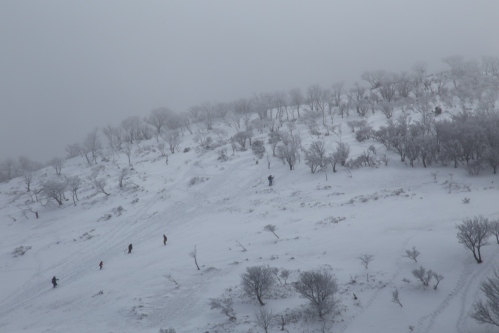
The car navigation was set to Gonami pass, where we would have a gentle 90-minute stroll on an undulating ridge until reaching the summit. There was only one problem: three-quarters of the way up the winding road we hit a wall of snow and could not continue. We parked the car and pulled out the gear, following the snow-covered asphalt the rest of the way until reaching the ridge at the mountain pass. It was already 2:30pm by the time we entered the forest, so we had to increase the pace if we wanted to make it back before dusk.

The contours on the map were misleading, as the route immediately climbed to the summit of a peak directly ahead. This was far too early to be the summit of Mt. Hachi, so we pushed on to the pinnacle before losing even more elevation on the other side. We soon left the cedar plantations behind and entered a forest forgotten by time. Beech trees rose gallantly along the untouched ridge and the sound of birdsong sprung to life among the bare limbs of the hardwoods. The unmistakable knocking of a woodpecker caught our ears, punctuated by the rustling of leaves to our left, the sound of a fawn seeking shelter from our unlikely intrusion. Off to the shaded northern slopes of the peak, tufts of snow grasped tightly to the contours like a cat clinging to a velvet drapery.

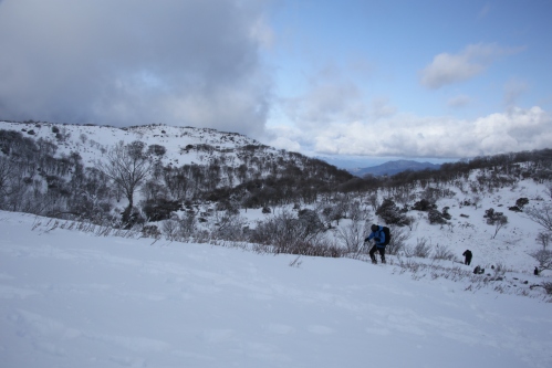
We took a short break at a trail joining the main path from the north. The final push to the high point lay just in front of us, but the snowfield hinted at the caloric workout, so we fueled up in preparation. The rotting snow made for slippery footholds but we managed by taking turns kicking steps into the wet slush. The summit was breached shortly before 4pm and afforded unobstructed panoramic views. My guidebook hinted at the origin of the mountain’s name. It’s not that there are eight peaks on the mountain range, but rather the odd spectacle that eight different provinces can be viewed from the top of the peak.

Back before the prefectural system of the Meiji era, Japan was divided into hundreds of provinces whose nomenclature still survives in mountain names and regional delicacies. According to this map from the Edo period, the 8 provinces likely seen from the summit were Tamba, Tango, Wakasa, Tajima, Harima, Yamashiro, Kyoto, and either Settsu or Omi. In the present day, these areas have been merged into the prefectures of Kyoto, Hyogo, Fukui, and Shiga, and on this particular day in April, the views were tinged in hues of yellow due to the Aeolian haze drifting over from the Gobi. On an exceptionally clear day, hundreds of mountains in every direction can be clearly identified on the horizon, but we settled for a neighboring view of Mt. Aoba before ducking back into the forest toward the waiting car.

We arrived before nightfall, having checked peak # 76 off the list. That pushed me over the three-quarters point. For the iconic #77 another mountain with a number in its name seemed worthy of attention. Perhaps a rendezvous with the mountain of 33 intervals was in order before the onset of the rainy season.