At the northern tip of Kyoto Prefecture, an oblong peninsula juts out into the Sea of Japan like a thumb looking to hitch a ride. This is the Tango Peninsula, a relatively untouched area dotted with secluded beaches, idyllic hot springs, and jovial locals who’ve settled into the slower pace and laid back atmosphere generally reserved for those living along the South China Sea. I’d been here once before during my quest to climb the Kansai 100, and here again I found myself on a mission to conquer Mt. Taiko, the highest summit in the entire peninsula.

As is usually the case, getting there would pose the biggest challenge. I had long since written off the mountain as impossible to visit without a car, but subsequent net surfing revealed a bus stop at the mouth of Saigawa river that was within walking distance of the summit, if you considered a 10-km walk along a winding forest road to be walking distance that is. I had the schedule nailed down and had even virtually walked the first part of the route using the streetview function of Google maps. A high pressure system settled over the Hokuriku region, which promised favorable walking conditions in an area that is a magnet for wet precipitation most of the year.

The train pulled out of Osaka station at 6:10am, chugging along the foggy tracks towards Fukuchiyama, where the Tango Tetsudo chauffeured the dozen passengers to Miyazu station, the terminus of the bus for Saigawa. Trouble was, the train was running behind schedule, meaning I would miss my connecting bus and have no way of making it to the trailhead without dropping yen on a budget-breaking taxi. The train was only 3 minutes behind schedule, so instead of alighting at Miyazu, I continued along to Amanohashidate station, where the bus was next scheduled to stop. Fortunately, the train was faster than the bus, and I had a few extra minutes to spare before boarding bus #9 and settling into a seat near the back. The ride took nearly 45 minutes, during which time I fueled up on energy bars and studied the paper maps courtesy of old man Google. It was nearly 10:30 in the morning by the time I put rubber sole to asphalt, and I had a really long way to go.

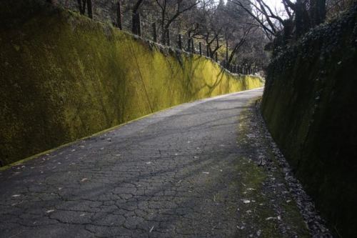
Road walks can really be a drag. Just read any of the posts on Notes from the ‘Nog to get an indication on how pedestrian-unfriendly Japan’s byways can truly be. Once you’re off the main roads and onto the village lanes and forest tracks, however, the going becomes a lot more pleasant on both the metatarsals and the eyes. I made good time up route 625 past Tenchoji temple and its rustic village slumbered down for the winter. At a fork in the road sat a shelter housing a fresh water spring. I paused briefly to rest the haunches and check my bearings. This was as far as the Google truck had driven, so from here on out I needed to rely on the GPS. Forest roads branched out towards the mountains above, and after a few twists and turns I breached the ridge of the mountains and officially commenced the ascent towards Tango’s lofty heights. While 683 meters may not seem like a tall peak, it all depends on perspective. Mt. Taiko is taller than any mountain in both Okinawa and Chiba Prefectures, and it’s only 300 meters lower than the tallest mountain in all of Kyoto.
After reaching the ridge, the vistas opened up towards the north, as a fortress of mountains lined the horizon , like a battalion of soldiers standing guard to keep unwanted visitors away. I would have to go up and over these peaks just to get within striking distance of Mt. Taiko. My heart sank as I suddenly realized the formidable task that lie ahead of me. Could I even make it to the top before dark? How on earth would I be able to return to Osaka in time for work the following morning? I continued on in silence, hoping that I could somehow muster up the courage and energy to continue.

Just as things started to look bleak, the unmistakable rumble of an automobile echoed from the valley below. The sound crescendoed until the utility van was on my heels. I leaped to the shoulder of the narrow road, stretching my thumb out on pure instinct. The vehicle halted its forward momentum as I opened the passenger’s side door. “Where are you going”, asked the white-haired man, dressed in a blue forestry uniform. “Mt. Taiko,” came my reply, in as soft and nonthreatening voice as I could muster up. “Hop in”, said the man.

After the initial shock of finding someone crazy enough to walk up an abandoned forest road, my saviour explained about the area and the lack of employment opportunities. “I came up here to check on the work of my employees”, gestured the logging company president, as we drove past one patch of cedar forest that he had come to check on. The timber had been felled, cut, and stacked into clean piles just as was ordered by the boss. “Timber is so cheap nowadays that people no longer enter the logging industry.” Seizing the opportunity, I inquired about the future of this clear-cut area, wondering if he’d be replanting it with cedar trees per the government protocol. “No, I’ll just let the natural forest reclaim it.”

In spite of the paved road to the top, there was a surprisingly large amount of native broadleaf remaining on the slopes of the mountain. I suppose that most of the prefectural coffers were invested in the prominent Kitayama cedar trees that still fetch a high price on the market. Any trip immediately north of Kyoto city will reveal the extent of the destruction of the native flora, as enormous mountains of cedar cut off the sunlight and blanket the city with giant plumes of suffocating pollen in the late winter. Luckily, the further north you get from the city, the lighter the destruction.

As we rose up towards the Tango highlands, large swaths of fresh snow covered the shaded parts of the road, prompting a bit of careful navigation from my driver, and a bit of excitement in seeing my first fresh snowfall of the winter. By the time we reached Swiss Mura ski village the entire slopes were blanketed in 10 centimeters of soft white crystal. I thanked my driver profusely and shouldered the pack for the short climb to the high point, which sat at the terminus of the highest ski lift. Rather than trudging through the banal contours of the open slopes, I stuck to the forested sections of the southeastern face of the mountain, carving a trail through the untracked powder until reaching a set of footprints from another visitor earlier that day. I followed those tracks until they ended in a thicket of undergrowth that was choking the hillside and had me second-guessing my decision to avoid the easy way up. Pushing my way through the virtual maze, I eventually skirted the southern edge of the ski lift and popped out in the grasslands just below the summit. When I reached the top I glanced at my watch to discover that it was exactly high noon.
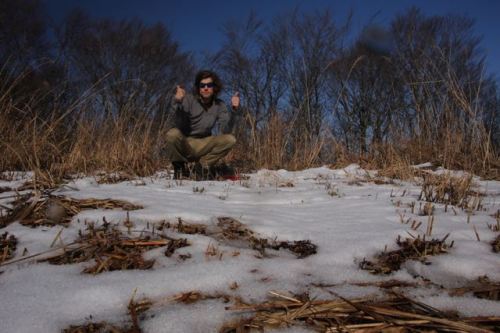
Sitting in a dry patch of yellow grass under the lift, I soaked in the warm midday rays and filled my belly with provisions. I was planning on walking all the way back down to the sea and I needed some heavy calories for the descent. Resting for only 15 minutes, I once again geared up for the long walk back to civilization, as I knew my chances of encountering another car were slim to none. Sliding my way back to the forest road, I took off on a brisk walking pace, following the prints of deer, boar, stoat, and fox as they led me further down the slopes. I soon reached the edge of the snow line and could now catch sight of the sea which still seemed an absurdly long way away. I couldn’t believe that I thought it a good idea to go from sea to summit and back again in only one day. If not for the extra help it surely would not have been possible.

When I reached the clear cut area that we passed earlier I checked my watch to find that it read 1pm. In 45 minutes I had covered roughly a third of the distance, so I set a new goal for myself – the 2:15 bus.

I stepped it into high gear, keeping a 6km-an-hour pace until slowing down a bit once I felt some blisters starting to form. The recent hiking shoes I had bought in the early autumn were just a bit too small for my feet, and my hopes of fully breaking them in were a failure. With such a tight schedule to keep, there was no time to rest just yet. Familiar landmarks I had passed on the climb now came into sight, as I had now reached the area that I had covered before being given the ride. I pushed on in agony, as each footfall triggered my sensory system to render messages to my brain to slow the pace. Finally, the water source at the junction of route 625 came into view. I trotted the last 50 meters before collapsing on a rock bench just in front of the spring. I immediately took off my shoes and socks to let my feet air out as I shuffled through the pack for the moleskins and band aids. I polished off the sports drink as well as a couple of energy bars and a block of chocolate. By the time I finished mending my feet it was approaching 1:45pm. Could I really make this bus?

I remember that it had taken me about 45 minutes to climb up to the junction, so there was still a chance of accomplishing my goal, but I’d need to push a 7km per hour pace to do it. Nevermind the wincing pain at every advancing step. I bit my lower lip and set off in a half trot, half skip down the paved road. I soon passed by a small temple I had seen on the way. As I looked over at the stone steps rising up to the main sanctuary, a patch of red caught my eye. A troupe of macaques were sunning themselves on the stairs, as if taunting me to take photos of them. There are rare occasions where I will turn down a photo op but this was one of them. I was going to make this bus, posing monkeys or not.

The final 10 minutes of the walk were a blur, but I somehow mustered up the energy to kick it into a full-on jog, as the sea grew closer and closer. Alas, I reached the bus stop with just minutes to spare, dropping my pack and tearing off my shoes in search of pain relief. I sat slumped in the comforting cushions of the bus seat, finally being able to take in the enormity of my quest. What surely should have been the easiest of the Kinki Hyakumeizan became one of the physically hardest and mentally toughest mountain to date. I’m not sure how many more of these lightning ascents I can take. Luckily for me, there are only 5 more mountains on the list.


