Feeds:
Posts
Comments

Archive for the ‘Kita Alps day hikes’ Category

The hardest part about planning a trip to the Kita Alps is finding a clear weather window in Japan’s notoriously fickle summer weather. The second hardest part of trip planning is figuring out a schedule that works for a trio of participants, all of whom are in various stages of the COVID vaccination process. With the Olympics in full swing and COVID-19 infections on an upward trajectory, we set our eyes on July 30th as our target date for an ascent of Niigata’s highest peak, my final summit of what I have dubbed the ‘Japan 47’ – the highest mountain in each of Japan’s 47 Prefectures.

Paul picks me up at Shinano-Omachi station shortly before noon on Wednesday the 28th. The train journey northward takes most of the morning, involving transfers at both Nagoya and Matsumoto stations. Due to the pandemic, the trains are running at a fraction of capacity, with many business commuters curtailing their business trips in favor of online meetings and their own private transport. The mask stays on for the duration of the ride – I’ve grown so accustomed to wearing the protective fabric that even naps are a pleasant affair. In the past, I had always avoided wearing masks as it made me feel as if I was suffocating, but now I hardly notice the minor inconvenience.

After hitting a supermarket for lunchtime snacks, Paul guides his vehicle along the narrow curves of route 325 behind Kashimayari ski resort. At a broad clearing near the top of the lifts, a juvenile kamoshika serow crosses the lane in front of the car, nonplussed by our intrusion as the creature climbs the adjacent forested slopes in search of nourishment. We reach the end of the road and a wave of nostalgia hits, as this is where Fumito and I camped back in June of 2007 during our ascent of Mt Kashimayari. In fact, it is up this same Akaiwa spur route that I now show to Paul. Conditions are exactly as I remember them, with a concrete tunnel built under the dam at the start of the long route. The afternoon heat slows our progress as we ascend the incredibly steep spur towards Takachihodai. Due to our late start, it will be impossible to ascend Kashimayari this time around, but we make good work of the track and give up around after reaching an altitude of around 1700 meters, still 1000 meters shy of Niigata’s highest peak but it is the highest altitude I have climbed in 2021 so far, so every little bit helps.

The following morning dawns clear, so I walk out in front of Paul’s house to a clearing where I stare up at Mt Hakuba-norikura shining bright in the morning sun. These clear morning views are usually short-lived in the summer, with the usual fog and rain clouds moving in for the remainder of the day. After breakfast, Paul and I head up to Kurobishi-daira near the top of Happo ski resort for a quick ascent to Happo Ike before heading down to Hakuba to pick up our friend Naresh. Thick fog and light rain await us as we reach the parking lot, and after a quick assessment, the two of us decide to continue with our plan, knowing we can turn around should the rain showers worsen. Forgoing the ski lifts, Paul leads me up a gravel road through the ski fields until reaching what he has christened “the concrete slope of death”, as the road suddenly turns to paved concrete and ascends directly up the steepest part of the ski slope. We make good time by cutting our own switchbacks through the no-nonsense approach. Halfway up we cross paths with a solo hiker making an unsteady descent down the path which forces me to grimace, knowing our same fate awaits us just a couple of hours later.

At the top of the slope we enter a verdant marshland lined with nikkōkisuge lillies and other colorful wildflowers standing out through the monochromatic backdrop of thick fog. The rain has stopped, giving us hope that what remains above may be a little more promising. At the top of the final ski lift the proper hiking track begins and we run into our first sneakered day trippers of the morning. Most of them are working their way down through the mist. With several paths to choose from, we opt for the lower track, which skirts just below the main ridge past a lingering snowfield on broad wooden boardwalks helping to aid in the ascent. All of a sudden, the fog lifts, revealing a mouthwatering vista of Mt Goryu that sends our hearts racing with excitement. We push on, with the cloud eventually catching up to us as we reach the shores of the pond. Lingering for a few minutes in heightened anticipation, the views gradually open up, revealing brilliant skies of azure hovering above Hakuba-yari. While the remainder of the Hakuba sanzan lay enveloped in cloud, Paul and I are content with just getting a glimpse of the fantastic scenery awarded to those that choose to ascent the ridge leading to Mt Karamatsu. We push on a little higher, reaching an altitude of around 2100 meters – a great acclimatization exercise for the following day’s planned ascent of Mt Korenge.

After picking up Naresh at the station, we head off for lunch and to plan the logistics of our impending climb. With several options to choose from, we decide that sleeping at a park near Hiraiwa onsen affords our best chance of making it to Renge Onsen in time to ascend Korenge for the sunrise. This entails an early start, so after packing and resting at Paul’s house, we eat a quick dinner and head to the hot spring for a quick bath before laying our sleeping bags in the sheltered comforts of the public toilet complex at the end of a quiet road. All is calm as we close our eyes around 8pm, and with the alarm set for 12:45am, we attempt to catch some shut eye. Around 40 minutes later, a rumble in the distance grows louder as it appears that a very large lorry is headed directly for our campsite. A large spotlight shines towards us as the noise crescendos and skirts past our front door. In our rush to catch some sleep we have failed to realize that our meager accommodation sits just meters from the train tracks of the JR Oito line, and our intruder is non other than the infrequent train carriage shuttling passengers to Minami-Otari. Two more trains pass by during the evening, robbing us of a good night’s sleep but still – the show must go on.

We are on the road at 1am as Paul guides his vehicle up the deserted road under the cover of darkness. Our first signs of wildlife suddenly appear, as a wild boar ducks for cover on the grassy slopes while further along, we come face to face with a massive buck who simply stares at us from frightened eyes on the shoulder of the narrow road. Shortly before 2am we park, unload the gear, and set off on our journey towards the alpine. I take the lead, setting a gradual but steady pace past some strong sulfuric fumes wafting from somewhere above. The famed outdoor baths of Renge Onsen sit off in a clearing on our left, and while the appeal of a soothing bath is hard to pass up, we all silently agree that these things are best enjoyed after a hard day on the slopes, so we push on with anticipation.

Our route is lined with a multitude of switchbacks through a healthy forest of hardwoods, and as we reach a clearing we turn off the headlamps and enjoy the moonlit views of Mt Asahi and Mt Yukikura sitting elegantly under calm and starlit skies. Winds are calm, almost unnaturally so, teasing us into thinking that this high-pressure system is sticking around for the long haul. Sweat trickles down my brow as I focus on the rhythm of my footsteps – with such a large vertical elevation change, it’s all you can do to keep your mind off of how much further you have to go. Signposts are affixed at around every 200 vertical meters of elevation gain, and by the time we reach the Tengu’s garden just above 2000 meters in elevation, the eastern horizon hints that dawn will soon be upon us. We still have roughly 3km to go before reaching the tree line, and along the uneven boulders of the rough track, progress is slow but steady. In a race against the rising sun, the luxury of taking breaks has been shelved in favor of maintaining our steady progress. The clink of metal against the rock diverts my attention, and as I turn around I witness Naresh snap his trekking pole in two in an attempt to dislodge it between two stubborn boulders.

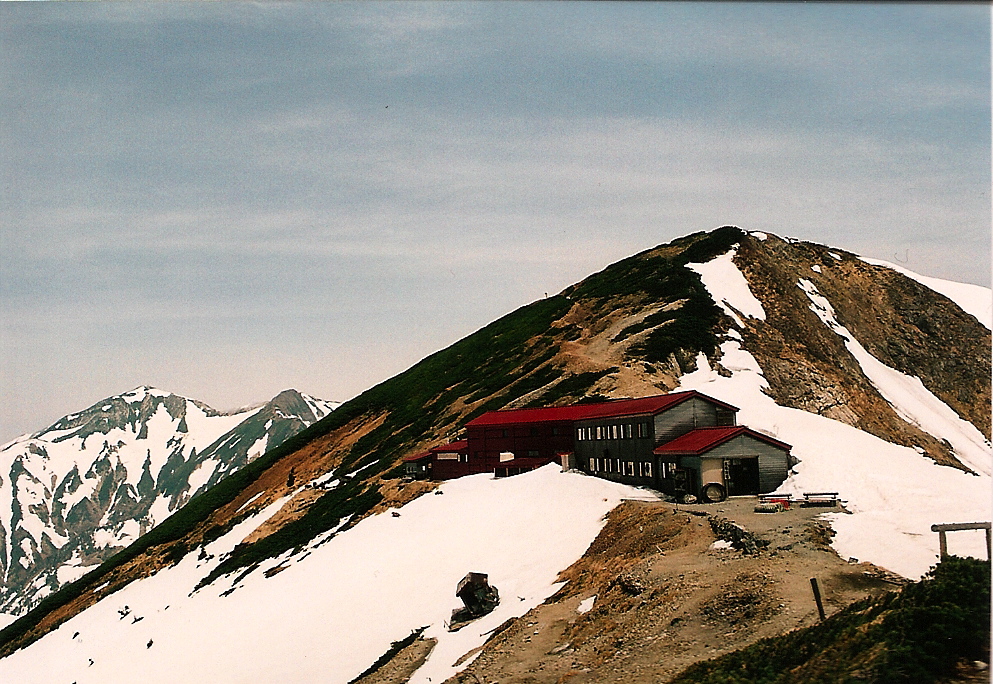
We with realization that our race with the sunrise is in jeopardy, I give permission for Paul to push ahead while Naresh and I hold up the rear. Paul wants to gaze at the first light of the new day from as high on the ridge as he can, while the two of us will be happy with ushering in the dawn by the shores of Hakuba-Oike pond. The track skirts the edge of a Erman’s birch forest before giving away to creeping pine and vast swaths of wildflowers carpeting both sides of the trail like a floral arrangement at a bridal fair. The red roof of Shirane-oike hut comes into view, together with the calm waters of the oval tarn. The sun remains hidden behind a thin layer of cloud on the horizon, giving us the upper hand. Naresh takes one look at me and pushes on ahead and for good reason: the higher we climb above the lake the better the vantage point of the rising sun.

It’s amazing how your body can adapt to the lack of sleep and relentless gains in altitude. We’ve been on our feet for nearly three hours and have not paused more than a few seconds to catch our breath, but I feel no fatigue nor drowsiness: it is as if sheer beauty of nature serves as my energy source. At the top of the rise, around an elevation of 2500 vertical meters, Naresh and I find what we are looking for: a small clearing of fist-sized stones which make for the perfect perch for our first break of the day. We have just minutes to spare before the first rays of light reach our face. What better way to celebrate than to break out my stash of chocolate covered coffee beans.

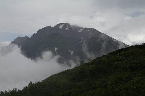
The temperature hovers around 15 degrees in stark contrast to the 30-degree temperatures a couple of thousand vertical meters below us. As the sun makes an appearance, we turn westward, mesmerized at the alpenglow hitting Mt Yukikura and Mt Asahi. Southwest of us, further above the undulating ridge, Mt Korenge sits in a thick swath of morning cloud. Is Paul sitting up in that cloud robbed of a view?

The path meanders past a series of large cairns and up into the true alpine zone, with a plethora of wildflowers, rock ptarmigan, and ever-expanding views to keep the mind off the sleep deprivation. Naresh takes up the rear, soaking in the scenery as I gaze skywards towards the cloud bank still clinging tightly to the summit. At the top of the rise, we reach the summit of Funakoshi-no-kashira and are awarded with our first clear vista of the Daisekkei along with the rest of the Ura-Tateyama mountain range lined up in succession. Stubborn cloud hovers around Mt Kashimayari and Mt Goryu, robbing us of a clear summit profile but our current vantage point demands our undivided attention. Naresh and I pause, taking it all in.

Descending to a saddle, with dizzying drops on our left down to the Ukijima wetlands, we follow the undulating contours of the ridge as it chauffeurs us up and over a series of false summits. I call out Paul’s name just before the crest of each rise before realizing in a dejected sigh that there is still quite some distance to go. Pushed on by an unseen force, the drive to summit Niigata’s highest peak, I continue, footfall by steady footfall, until I glimpse the fog-tinged silhouette of a dozen hikers standing on the true summit as the realization of my impending accomplishment starts to weigh on my emotions. Twenty years has this long journey taken me, not only up the Nihon Hyakumeizan but beyond, to the corner of every prefecture in this geographically diverse archipelago as I attempt to accomplish what no other foreigner, alive or dead, has ever done. My eyes moisten at the thought, but I fight back the tears and take my final steps with a smile instead.

Upon reaching the summit, a round of applause emanates from the other hikers as Paul offers his congratulations. As we set up for celebratory photos, the clouds suddenly part for the first time that fateful morning, leading to an improvised chorus of oohs and ahhs from our mountain spectators. I break out the banner my father-in-law made for me and snap a few photos in the unexpected sunlight. My watch reveals that it is just past 6:30 in the morning, the climb having taken us around four-and-a-half hours. We rest of the summit and enjoy a snack while Paul tries to coax me to continue my hike by summiting Mt Shirouma. Naresh has never climbed that peak but I am not interested in climbing it as the summit is still covered in fog. Plus, I have done what I set out to do, and there’s no reason to risk altitude sickness or a turned ankle by overstaying my welcome. Paul passes me the car keys while I sit on the summit, watching my hiking companions as they disappear toward the enveloping cloud.

With the highest mountain in each of Japan’s 47 prefectures now successfully climbed, I can now announce my retirement from peak bagging. While chasing mountain summits has been a lot of fun, I will no longer let my hiking destinations be determined by a list of arbitrary mountains. From now on, I will make my decisions based on my own criteria, which will mainly involve climbing peaks that look interesting, that lie further off the beaten path, and have not been included on anyone’s subjective list of ‘famous’ mountains. Stay tuned as I continue my travels deeper into the unexplored innards of this amazing country.

Read Full Post »

“Are you going to bring your rain gear?”, shouts Paul from the other side of the tent. Looking around at the blue skies surrounding the alpine peaks, and the paltry 20 percent chance of rain forecast for the day, I reply in the negative. After all, with clear views of our target peak all morning, and no wind to speak of, how could the weather possibly change?

And with that, the two explorers set off from camp, armed with a fresh map and a few snacks. As we turned from the road to the trail, the temperature suddenly started to drop and the sun disappeared behind clouds that were concealed above a thick forest canopy. It definitely felt like rain was on the way, but perhaps we’d be lucky enough to miss the worst of it. It was Paul’s first time to climb the only active volcano in the Kita Alps, and it was my first chance to check out the route from Kamikochi, which became steeper with each ascending footprint.

After an hour of hiking, Paul and I reached a clearing at the base of a set of cliffs. We wondered which way the trail would go, spying the rocks above for a hint. “Straight ahead,” pointed my companion. We could just make out the throngs of a long aluminum ladder, bolted to a neighboring rock formation. As we reached the vertical climb, a lone Japanese hiker started the vertigo-inducing descent. One slip here would be deadly. I knew the climb up would be a breeze, but I dreaded the inevitable – having to come down that thing later in the day.

Once past the ladder, the path entered alpine territory, with an array of colorful flowers in full bloom, and a meandering trail laden with switchbacks. It was somewhere around here that the skies started to open up, turning from drizzle to an all out downpour. Now I really was starting to regret my foolish decision to leave the rain gear in the valley below.

We rested briefly at the hut until the rain abated. From the hut the path climbed on the true ridge of the mountain range, reaching a lookout point in about 10 minutes or so. Steam from volcanic vents rose up mysteriously in the murk and from the pumice boulders strewn carelessly about. This would not be a good place to be in an eruption, so I silently prayed Yake would not decide to belch while we were visiting. From here the trail drops steeply to a saddle and starts the final, relentless climb to the summit.

This would be as far as I ventured, however, as the skies erupted in a downpour much heavier than before. The clouds hung thick to Yake’s conical figure, as the rain penetrated my thin layers instantaneously. I’d been up Yake in preciously the same conditions before, and a revenge climb doesn’t make much sense when the view is blocked by clouds. I sent Paul off to the summit alone, while I gracefully retreated back to the hut. Once there, I ducked inside and ordered some instant noodles. We had no food in our packs other than a few bags of mixed nuts, and I was starving. I waited out the rain in the luxury of the hut while chatting with another solo climber who’d just come from Nishi-hotaka hut.

An hour later, the rain once again stopped and I headed back up to the lookout point in search of Paul. Mt. Yake drifted in and out of cloud as another man stood by the rocks, searching for his hiking partners. It seems that I wasn’t the only one who gave up on the summit attempt. After 15 minutes or so, 3 figures appeared on the crest of the ridge back down to the saddle. We shouted to them and they replied by waving their arms. I couldn’t remember what color rain gear Paul had on, so I waited patiently for the group to arrive. A young couple eventually wandered up, informing me that my friend was about a half hour behind them. The group worked for one of the hotels in Kamikochi and were up for a bit of a day hike on their holiday. As with the majority of hotel staff in Kamikochi, they were from Kansai. I think the people in Osaka are smart to escape the summer heat and accept employment in a beautiful area with temperatures that barely break 30. They offered me their leftover rice balls, which I gently tucked inside my pack, waiting for Paul’s return to break them out. After bidding farewell, I stood alone on the summit, 2100 meters above sea level, and peered into the murk. A lone figure in green rain gear slowly made its way down the steep trail, meandering as if in a drunken stupor. I yelled up to the ridge line, which seemed to snap Paul out of his contemplative trance. Once we were reunited, I stuffed the rice ball into his waiting fist and asked about the summit climb. “Brutal”, he replied. “I almost gave up after getting lost among the hissing boulders”. Our map marked this trail as difficult to pick up even in good weather, so I wasn’t surprised by the navigability issues.

The rice balls seemed to give up that much needed jolt to get us moving off the mountain. We slid past the hut, down the flower field, and over to the base of that vertical section of ladder. I took a deep breath and slowly lowered myself over the abyss.

I don’t know when I became such a softie when it comes to heights, but I was downright scared when making the 10 meter drop. The trickiest part was about halfway down, when two ladders were tied together. Due to the awkward angle, you couldn’t see your footing at all, and had to trust your instincts. Eventually we both made it through the danger zone and back into the darkened forest. I still had a bit of energy in me, but Paul looked completely zapped and he could barely keep himself on the trail. We took a break at the first available flat area, stretching out our weary knees and finishing off the last of the rations.

From here the walking became much easier, and we soon found ourselves back on the forest road. It was approaching 4pm, and we’d missed our window of opportunity at the hot spring, where the baths closed at 3. To make matters worse, the skies opened up again, soaking my hiking gear that had managed to dry on the descent. The temperatures plummeted, as goose bumps covered my exposed skin. I could definitely use a jacket now, I thought, picking up the pace back to the campsite. Luckily our home had a bath that closed at 7pm, so we jumped right in and thawed out our bodies.

Mt. Yake had definitely won the battle that day, and I couldn’t really call the revenge climb successful, as I’d been robbed of a view of Yake’s elusive emerald green lake. I promised myself that I’d be back for a third round, but this time armed with some rain gear and a decent lunch.

Read Full Post »

Fumito met me at Hakuba station early on a cool October morning. The further north the train went, the worse the weather became. Our original plan was to conquer Mt. Goryu, but as Fumito and I stood under the station shelter in the cold, pelting rain, we changed tack and looked over my list of remaining peaks. “Hmmm”, I muttered, “Mt. Yake doesn’t seem so far from here.” I jumped in Fumito’s car as we headed south, towards the sunny skies of Matsumoto. Matsumoto city sat in this unique pocket of sunshine, surrounded by heavy cloud on all sides. Fumito pointed the car west, towards Kamikochi and the dark foreboding skies. A hour or so later we rounded the switchbacks above Nakanoyu hot spring and parked at the trailhead.

Faced with exactly the same wet skies as Hakuba, we put on our wet weather gear and ducked into the forest. Our logic for choosing Yake was, at 2400 meters above sea level, the weather was less likely to turn to snow as our original destination, which sat 400 vertical meters higher. We pushed through the virgin forest like two mountain lions chasing prey, and soon we found ourselves on the slopes of the hissing volcano. Once we hit the ridge, the winds increased 5-fold and the visibility cut to less than 1 meter. Turning left through some sulfuric steam vents, we topped out sometime in the early afternoon, sticking around only long enough to snap a quick photo before seeking shelter from the wind. Fumito broke out the stove at the base of a large rock formation while I jumped around to stave off hypothermia. Though the rain had let up, the wind was ferocious, signaling that the weather front was moving through. Tomorrow was likely to be a clear day, but neither of us wanted to stick around to find out.

Once back at the parking lot, we soaked in the nearby baths for nearly an hour, trying to bring feeling back into our frozen appendages. Fumito then dropped me off at Matsumoto station, where I checked into a hotel and prayed for good weather on the next day’s visit to Mt. Norikura.

Read Full Post »

The most direct route from Matsumoto to Osaka is not up and over a 3000m high volcano. Regardless, I somehow convinced myself that climbing Mt. Norikura is indeed on my home and I’d be foolish enough not to drop by and say hello. This justification had nothing whatsoever to do with the previous day’s soggy ascent of Mt. Yake. Nor did it have any connection to the picture perfect weather that presented itself on a wonderful autumn in early October.

norikura1

I checked out of the hotel early and boarded the train to Shin-shimashima, where a bus was waiting to whisk me to Norikura-kogen. From there, I queued up for the long, windy shuttle bus to Tatami-daira, the site of a recent bear attack. The overdeveloped plateau, situated at 2700m above sea level, cuts a good 1000 vertical meters off of what used to be a challenging climb. The massive parking lot is a testament to the extraordinary crowds that swarm the peak during the summer months, but on this calm, cool Monday morning there was hardly a soul in sight.

norikura2

I flew up towards the summit of Mt, Fujimi, only to be slowed by an endless array of wooden steps built into the exposed hillside. “Perhaps I should’ve done a few laps around the parking lot before setting off,” I admitted, realizing I was an early victim to the thin air. Panting like a out-of-shape St. Bernard on a hot, muggy day, I tiptoed up to the top of the peak, where, on a clear day, the conical shape of Mt. Fuji stands out on the horizon. Clarity wasn’t a problem on this particular morning. Even though I could see every other peak within a 200km radius, Mt. Fuji and the peaks of the Minami Alps were playing a game of hide-and-seek among the convective clouds.

norikura3

Mt. Norikura, like its more sacred neighbor Ontake to the south, is a volcanic plateau darted with
scenic volcanic lakes. In fact, most of the visitors stay on the asphalt trails well below the semicircular peaks above. I had Mt. Fujimi completely to myself, but ran into a few groups as the trail met up with the concrete again. I didn’t mind, though, as the outstanding weather more than made up for the unwelcome companionship.

norikura4

Scooting along on a concrete path, past a large, well-equipped mountain hut, I finally caught a glimpse of the summit of Ken-ga-mine, the high point of Mt. Norikura. With my body finally acclimatized, I flew past crowds out crawling pensioners until reaching the large shrine on the peak. Panoramic views in all directions more than made up for the misty drudgery of the day before. Mt. Yake stuck its steaming tongue out as if to tease me for climbing in such bombastic conditions. “Revenge will be mine”, I vowed.

norikura5

After the necessary summit proofs, I retraced my steps back to the parking lot and caught a bus towards Takayama and then a train back to Osaka. Mt. Norikura definitely thanked me for dropping by on the way home, and wished me luck on my upcoming attempt of Mt. Arashima, mountain #39.

Read Full Post »

The summer of 2006 was turning out to be truly epic. After an incredible 12-day, 10 mountain stint knocking off the peaks in Tohoku, I decide to up the ante by attempting an up-and-back ascent of Mt. Jonen, a behemoth monstrosity towering over the wasabi plantations of Toyoshina city. Map times suggest allocating 8-1/2 hours for the round-trip journey, so Fumito and I were keen to get an early start.

jonen1

Fumito picked me up at Shiojiri station, breaking the news to me as gently as he could: “the forest road to the trailhead is closed, so we’ve got an extra 4km hike each way.” We head to a nearby restaurant to work up a game plan before agreeing on a 3:30am departure. We pick up supplies before heading off for some rest.

jonen2

Dusk had barely shown itself as we headed up the deserted forest road. After a pleasant 3-1/2km warm-up we found the reason for our extra work: directly in front of us lie a 20m wide crevice, the victim of some major erosion during the most recent rainy season. Makeshift scaffolding formed an unsteady bridge across the gaping hole, and 200 meters further on, a huge beech tree sat directly in the center of the road, having miraculously stayed upright after sliding down the adjacent hillside. Once reaching the start of the hike at Hiedaira we made excellent time, following a beautiful river up the ravine towards our target peak.

jonen3

We hit a comfortable stride, surprisingly even ourselves by knocking through a section in a little over an hour that the map said would take 3-1/2. We took our first real break at the point where the trail left the cool waters of the river and started the steep zig-zag towards the ridge line. It was here that we met our first hikers of the day, having descended from the higher peaks earlier that morning. The sky was a deep azure, but we’d knew the cloud would inevitably roll in as the heat from the valley below met the crisp mountain air. Could we make it up before being enveloped in a torrent of cloud and mist?

jonen4

Our pace remained constant until reaching the hut at the saddle. 2400m above sea level, with the Hotaka range spread out directly in front of us. Mt. Yari was socked under a thick blanket of fog, while Oku-Hotaka was beginning to hide its head for the remainder of the day. Meanwhile, the clouds were building directly behind the summit of Mt. Jonen, a mere 400 vertical meters away.

jonen5

Despite the proximity, our pace slowed to a crawl, a victim of the thinning air and encroaching cloud cover. We had maybe 500 meters between us and the summit, but were making serious vertical elevation gains above the tree line. The hut we just departed from grew smaller and fainter by the minute, until it disappeared out of view completely. Undaunted, we pushed on, breaking out of the clouds just before reaching the signpost and tattered shrine on the exposed summit. We’d done it – another peak with a view as we stood in T-shirts at 2800m, wiping the hard-earned sweat from our brows.

jonen6

We wasted no time in descending my 64th peak, fearful that the thickened coverage might spawn an afternoon thunderstorm. Back at the forest road, we slowed our pace again, reflecting on our gargantuan effort. The hot spring we visited a short time later was most refreshing, as was the torrential downpour we experienced in the outdoor bath. Once again we’d beaten the rain, but I knew that my luck would eventually run out during the impending typhoon season. After all, my goal of reaching #75 by year’s end was truly in sight.

.

Read Full Post »

Exactly 2 weeks to the day after my thrilling climb of Mt. Amakazari, I sit in a tent at the beginning of a gated forest road, plotting my next move. Fumito and I are about to embark on another gargantuan hike of a mighty mountain, during the rainy season! Could I continue my lucky streak in the battle against the rain?

kashima1

4:00am. With the skies still dark and the wind calm, breakfast is cooked and served. We’ve got a long way to go on one of the toughest day hikes in the Kita Alps, so an early start was critical. After breaking down camp, I took a short stroll across the river to try to catch a glimpse of the ridge line, in hopes of assessing snow conditions. Crampons were foregone in favor of ice axes. The weight we’d save would be replaced by nutrients. The red glow of the sun on the high peaks was promising, as was the lack of cloud cover. Barometer readings were also in our favor, so we set out on the long, deserted forest road in high spirits.

kashima2

At the end of the road, we headed into the hills, along the Akaiwa spur for a 1200m+ altitude gain. Step by step we rose high above the valley, shedding layers of clothing with each advancing trot. It was hot, and oh so clear. “What happened to the rainy season?”, I asked Fumito, hoping that my question wouldn’t set mother nature off on a temper tantrum.

kashima3

About 90 minutes into our climb, nature threw up its first road block: a huge ice fall blocking the path in front of us. Beyond that, there was a steep snow field that was impassable without crampons. By sheer luck, someone had hacked out a ridiculously steep alternative route, bypassing our obstacle. Grabbing whatever lay in our path, we forced our way up and around the barrier. Fumito took the lead, while I followed a short distance behind. All of a sudden, my companion lost his balance and grip, sliding above me to my left. Acting on my reflexes, I reached out and grabbed his backpack, but the bag slipped right through my hand, cutting two fingers in the process.

Just as my worst nightmare was beginning to see the light of day, I witnessed the most impressive feat of my entire existence on this earth. Tumbling barely 5 meters, Fumito somehow managed to break his fall in the canopy of a small beech tree, thus averting a major disaster. The entire event unfolded in the blink of an eye, as the luckiest man in Japan climbed back up while I tended to my wounds. “I’ll take the lead from here,” I quipped.

kashima5

Once out of the danger zone, we found the normal path and took a break to reflect on what transpired. Fumito was completely unharmed, and I’d lost some skin on my fingers, but the bleeding had stopped so we ventured on. We arrived at Takachihodai, where our first glimpse of Kashimayari came into view directly in front of us. If we could somehow build a rope bridge over the huge valley between us and the peak, then we could cut a few hours off the slog. Unfortunately, we’d have to continue climbing parallel to the peak until reaching the ridgeline, where we’d be able to head over to the summit.

kashima6

The path became much rockier after leaving the flat area, but fortunately most of the snow was gone. Just before popping out on the ridge though, we had to traverse through a large, unstable snow field. I was petrified of breaking through the snow and tumbling down to my death, so Fumito once again took the lead. This time, he kept his footing and I managed to avoid the holes, but we wondered how we’d be able to traverse it on the descent.

kashima7

We hit the main ridge line, where Tateyama and Tsurugi were patiently waiting. Mt. Fuji even popped her head out on the horizon and the sky looked as if satsuki-bare had never left. We marched on to the mountain hut and filled up on water. Then came a gargantuan climb through an enormous snowfield to the summit of Mt. Nunobiki. Exhausted we were, but we plodded on, reaching the top of the southern peak just before noon. Mt. Kashimayari, just like Mt. Shiomi in the Minami Alps, has a twin peak a short distance away. After eating lunch, we dropped to the saddle and climbed the twin, staring down into the vertical crags on the Hachimine-kiretto. There’d be no traversing over to Mt. Goryu this time around, even though it was still on my ‘to climb’ list.

kashima8

We ran into a handful of people on the summit, but all of them had come from Ogisawa – a much longer but easier approach. After celebrating our successful ascent, we retraced out steps back to the junction, thinking about the tricky snow traverse that lie ahead. This time around I took the lead, and was extremely surprised to find that some kind soul had built steps into the snow pack, making for an easy and comfortable crossing. My guess is that the hut staff must’ve come over here with their snow shovels, or perhaps another hiker had come up behind us. Whoever it was, I can’t thank them enough.

kashima9

Descending took no time at all, and the high pressure system stuck around for the duration of our hike. Walking back on the deserted forest road, Fumito and I chatted about our previous adventures and wondered if we’d be able to get together again this year for more hikes. I hung up the hat after this one, deciding not to tempt fate again until after the rainy season, where mountain #83 was quietly awaiting.

Read Full Post »

Mt. Goryu

My plan was simple. Catch a train to Kamishiro arriving around dusk. Hike to the top of Goryu ski resort at night, camping somewhere near the top. Wake up at the break of dawn, climb to the top of Mt. Goryu, and descend back to Kamishiro station in time to make the 4:35pm train…..could it be done?

I arrived at Kamishiro at 7:16pm and headed for Escal Plaza. My map had a supermarket marked a short walk from the station, but was shocked to find it was only a small, family-run pharmacy/convenience store with few provisions. The first thorn in my side – nothing to eat for dinner! I remember a “Pizzakaya” named Country Road, located adjacent to Hakuba Alps Backpacker hostel. Would it be open on a Thursday evening in late May? Bingo! Dinner was served and I stuffed myself. Around 8:30pm, I left the warm confines of the friendly Izakaya and headed off into the unknown. Well, that’s not entirely true. I’d been snowboarding a few times at Goryu ski resort, so I had a fair idea of how to get to the top.

As I trampled through the bunny slopes, two options became immediately apparent. I could take the gravel road all the way to the top, which winds its way through a dark forest, or I could shoot directly up the black diamond course, straight to the top. I didn’t really fancy meeting any ferocious creatures, so wanted to steer clear of any dense foliage, especially considering that I’d forgotten my bear bell. A huge mistake, as the expert ski course was easily the steepest, most difficult thing I’ve climbed in a long time! Sure it would be easy in the daytime with a small pack, but imagine carrying 3 liters of water, a zero degree sleeping bag, and heavy tent! Plus, to top it all off, about 10 minutes up the slope a large rustle came into earshot to my immediate right. Footsteps trampling just out of my headlamp beam reach. “This is it”, I thought, wondering what the headlines might read the next day. Then, I heard the familiar “ff-ff”, “ff-ff” sound. I’d heard that sound once before, when descending Mt. Ryokami, I came face-to-face with a Kamoshika. They make this really unique thumping/hissing sound to try and scare away prey. I realized that it was a Kamoshika, peeping out from its hunting ground to inquire about my noctural invasion.

The ski field was much, much longer than I remembered, but that’s because it only takes a fraction of the time to descend on a snowboard. I finally gave up around 11pm, when I reached the bottom of the #2 & #4 ski lifts. Awating me was a nice wooden platform sheltered from the wind, with outstanding views of Hakuba below, a full moon rising above the peaks to the east, and a rather run-down but usable toilet. In addition, there was a ski office that was left unlocked! I had immediate shelter in case the weather turned foul. I even considered sleeping in the office, but figured I might as well pitch my tent since I went through so much trouble just to bring it up here. I set the alarm for 4am and crawled into my bag.

It’s funny how early you can naturally wake up when you’re in the outdoors. I rolled out of my bag at 3:30am. I wasn’t the least bit hungry, so started my preparations. I knew I was coming back to this place, so I had enough hindsight to pack an extra day pack to use for my assault on Mt. Goryu. I put my heavy pack next to the toilet, and started on my way. I made it to the top of the ski resort, where I checked a mountain hut I had spied in the winter. It’s marked as a “ski hut” on the map, and sure enough, it was firmly locked. I then knew I had make the right choice pitching tent where I did. I made it to the top of the resort just at the sun was casting pink hues on the alpine peaks above. I could only imagine what kind of sunrise the employees in all the mountain huts must’ve had.

The first few hours of hiking were fairly non-eventful, until I reached the col just below Mt. Shiro. Since it was my first time there, I wasn’t sure if I needed to hike up and over Mt. Shiro or if I could just make a bee-line directly ahead toward the hut. I couldn’t see the hut at all, but the map marked in the saddle between Goryu and Shiro. I decided to play it safe by following the footprints up towards the white peak, hoping that my predecessor knew what he/she was doing! About 50 minutes later, I was sitting on top of Mt. Shiro, patting myself on the back for not falling into any crevices or giving up. A quick descent to the hut, where I surprised the lone hut staff. He asked me if I came from Karamatsu, but almost fell off his chair when I told him I’d come from Goryu ski resort. I guess most people don’t arrive from that direction at 7:30am! He breathed a sigh or relief when I told him I’d camped in the ski resort, since the gondola wasn’t running. Anyway, I hadn’t brought any lunch with me because I knew the hut was open and had images of a hut teeming with hikers and the pleasant aroma of curry and rice. Oops! I should have known that there’d only be one staff member who solely prepares meals based on the number of people staying the night.  Luckily, I was able to purchase a bowl of instant noodles – not on the top of my culinary wishes, but it would have to do. I decided to hold off on lunch until summiting as a reward to myself. I asked for climbing advice and went on my way.

The hut staff recommended I stick tightly to the ridge line, where there was absolutely no path but at least there was no snow. I did the best I could scrambling over the boulders and being careful not to trample any potentially endangered foliage. The ridge was steep and rocky, with lots of ups and downs. I even found the real path on one occasion, and followed the paint marks briefly until they disappeared into the snow. Eventually, I found myself on the final traverse to the rocky summit, and was awarded with an outstanding view of Mt. Tsurugi. The signpost has definitely seen better days, as someone had put a piece of tape marking the summit. This is in stark contrast to the concrete-embedded signposts of the Shizuoka Prefectural section of the Minami Alps!

I flew down the peak as fast as I safely could. At one point I tried to descend through the snow, but it was very steep and difficult to get traction (even with crampons on!). I took two steps and ended up on my butt, sliding at lightning speed toward most certain death. Luckily I knew how to stop myself with my ice axe and slid very, very slowly toward the nearest rock formations I could find. I had built up my confidence by sliding down Mt. Hiuchi a few weeks prior, but this terrain was much steeper and faster than anything I’d been on before. The snow was soft and somewhat slushy, but that seemed to make it faster!

Eventually, I worked my way back to the hut and feasted on Kitsune Udon. I also bought some bottled water because the hut was using melted snow and rain water as their drinking supply. If I’d brought my water filter then I could’ve opted for that, but I decided to not risk it on this trip. I’m still amazed by how many Japanese hikers willingly drink from untreated mountain streams. Anyone know the giardia stats for Japan?

I took the shortcut back, bypassing Mt. Shiro. This can only be done in the winter or spring, when snow still covers the entire col. I flew back to the ski resort, and made it back to my heavy pack a little past 1pm. I looked at the train schedule. Could I actually make the 3:36pm train? A challenge it was! This time I decided to stick to the forest road through the ski resort. My feet were killing me, but I didn’t want to risk tumbling down the black diamond course with a 20kg pack! I walked the entire way without taking a break, and made it to Kamishiro at 3:21pm. Phew! Another peak bagged, and time to plan my next alpine adventure.

Read Full Post »