Feeds:
Posts
Comments

Archive for July, 2016

On my last visit, I vowed to never return, but something kept drawing me back. Like a page in a diary you’re not supposed to read, I just had to find some kind of redeeming quality to a plateau scarred by the scalpel of development. Would Fukada himself be spinning in his grave to see what has become of his beloved mountain? Perhaps not, as his ‘famous’ book refers to the “toll road” that “had been built into the heart of the mountain.” Could this be the Odaigahara Skyline, which now runs to within spitting distance of the high point?

IMG_6536

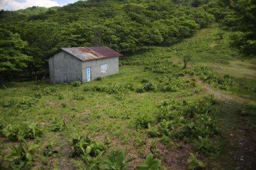
On the long, winding drive up the skyline, the bus vanished into a thick wall of cloud that frequently lingers around the plateau. Clear days are hard to come by, and even the beautiful sunshine and crystal clear skies of Osaka could not penetrate the fog fortress. I disembarked into this blanket of mist and immediately retreated into the souvenir shop/restaurant to use the facilities. I also inquired about the closing time of the noodle shop, as I’d planned to grab a bowl before boarding the final bus at 3:30. I had roughly five hours to spend in my search for that spark.

IMG_6555

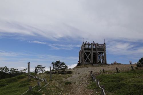
The long-familiar trail to the high point starts in front of the visitor’s center and is in incredibly good shape despite the heavy foot traffic. On this cool, misty July morning, I was pleasantly surprised at the lack of crowds, as my other two experiences came later in the season, when flocks of camera wielding tourists line the paths in search of that perfect autumn leaf. I passed just one trio hikers before reaching the main junction below the peak of Hide-ga-take. A lookout platform had recently been built here, as a way of keeping the actual summit from getting overloaded with hikers. Signposts teased visitors about the splendid views of Mt. Fuji from this vantage point, but in the dense fog I could do little else than use my imagination.

IMG_6549

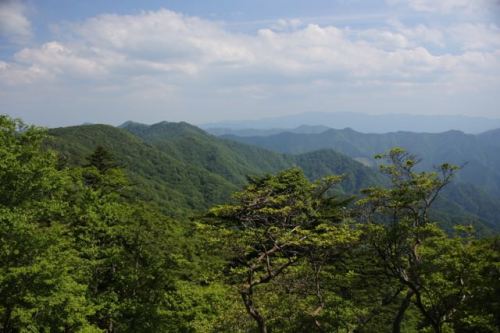
The summit was teeming with hikers, including a rowdy group from Mie Prefecture who were well into an altered state of inebriety, with the leader chain-smoking away like he was at his neighborhood izakaya. In the short interval between drags I moved in to have a friendly chat, and was rewarded with homemade inari sushi as well as the famed Yoshino delicacy of sushi wrapped in persimmon leaves. As we chatted, the sky lightened up and the cloud dropped, revealing a sea of cumulus stretching out to eternity. I climbed to the second story of the concrete resthouse to take in the views. Unfortunately, the Omine mountains were still hiding in their own bank of menacing cloud, but it was a much better alternative than fighting off the strong winds and horizontal rains. A quartet of deer sat just off the lee slope of the narrow summit, grazing with an air of accepted indifference.

IMG_6592

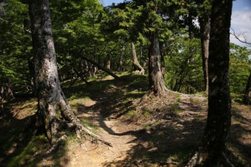
I retraced my steps back to the junction and continued traversing south towards Daijyakura cliffs on the far end of the plateau. The cloud stayed low, affording vistas back towards Mt. Hide’s knuckle perch. A series of wooden steps have been built across much of the plateau, and the unexpected sunshine had begun to dry things out a bit. These wooden walkways are slicker than ice rinks when covered with a layer of water, but on the dry promenade I could focus on the scenery more than my footfalls.

IMG_6659

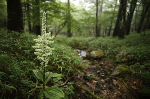
And what scenery it was. An endless carpet of bamboo grass stretching out beneath the boardwalks, with needle-like stalks of dead trees poking out at irregular intervals. Apparently this used to be a healthy forest until a very strong typhoon swept through and knocked all of the trees off their foundations. The toppled trees allowed more sunlight to penetrate the forest floor, which dried out the moss and allowed the bamboo grass to thrive. The grass, in turn, attracted the deer, who ate the bark off the trees and helped to destroy the remaining forest.

IMG_6657

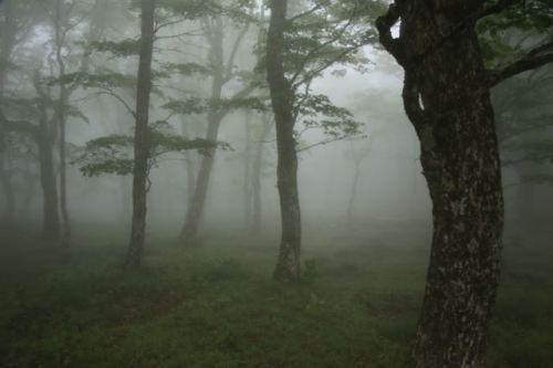
I pushed on, ignoring the junction loop trail back to the parking lot and continued towards the cliffs. Dropping out of the sunlight and back into the fog belt triggered a sudden change inside of me. For here the true magic of the place presented itself, in a stunning reminder of the necessity of condensation on the delicate ecosystem. The beech trees looked happier and full of life, as this section of moss-laden woods lay sheltered from the strong winds that often push through the massif.

IMG_6749

The wildlife seemed to welcome the change as well, as a badger crossed the trail just in front of me and foraged through the grass in search of an early afternoon meal.

IMG_6763

Soon I reached another flatland, with a giant statue of emperor Jimmu standing guard. Fukada mentions this statue in his book, but how in the world did they get that thing up here? It must’ve been erected around the same time that the skyline was complete, which leads me to believe that Fukada did actually visit when the road did run all the way up the plateau, though in his time I sure it was a simple dirt track and not the meandering asphalt serpent of today.

IMG_6786

I reached the junction for the cliff lookout point and dropped down for a look, or at least a glimpse of what the area looked like. The cloud still had a tight grip around the towering beech trees lining the narrow path. It took about 10 minutes to reach the observation point, lined by a chain railing to keep the tourists from tumbling down into the void. Apparently it’s a vertigo-inducing spectacle in clear weather, but with nothing to see I felt safe walking all the way to the edge to peer down into the white void.

IMG_6803

I sat for a while and waited for the clouds to lift, but the wait was in vain. Rather than feeling dejected, I silently relished in hidden delight, for this gave me an excuse to come back in the future.

IMG_6864


Back at the junction, the route passed through a tunnel of rhododendron bushes before losing close to 200 meters of vertical altitude until reaching a clear brook. A suspension bridge offers safe passage for visitors, and once across the stream the long climb back to the parking lot commences. Signs on my left warned that the trails of Nishi Odai-ga-hara are off-limits to those without special permission to enter. It seems as if the higher ups are finally starting to care about conservation.

IMG_6879

I reached the parking lot around 3pm and had a quick bowl of noodles before boarding the bus. Maybe it was the humidity, or just the weather, but the crowds were much more manageable and dare I say pleasant on this third trip to the plateau. Perhaps the green season is indeed the best time to experience the magic of Odai-ga-hara. It may be too early to tell, but I’m really starting to warm up to the place. I think a future trip to Nishi Odai-ga-hara may just seal the deal.

Reference

One Hundred Mountains of Japan by Kyūya Fukada, translated by Martin Hood, University of Hawaii Press, 2015. More information about Fukada’s mountains can be found here, and the translation can be purchased here.

Read Full Post »

Late May and a break in my busy schedule had me scrambling for a quick excursion to the final two mountains in the Daiko range. By setting up base camp at Myojin-daira, I hoped to knock off both Myojin and Hinokizuka  in one fell swoop. I needed some wingmen, however, so I turned to Paul M. and Josh, my two companions from Mt. Tsubone, which sits just across the valley from my target peaks.

IMG_1845

Our meeting point was Haibara station, where we loaded the gear into the back of Josh’s kei car and picked up provisions at the local supermarket. The drive out to Higashi Yoshino village was slow yet pleasant, following the meandering Hōno river until it converged with the Takami river and up a secluded valley towards the rustic hamlet. Higashi Yoshino is best known for the last officially recorded sighting of the Japanese wolf, which wandered into the village back in 1905 for a one-way ticket to the taxidermist. There have been several reported sightings in the decades since, but with the massive post-war clear cutting of the broadleaf forests, it is unlikely that the Canis lupis could have survived such habitat destruction into modern times.

IMG_1869

Just before the village office, the route abandoned the river and forked left, past a quiet hot spring and campground and towards the trailhead of Omata, which lies at the terminus of a concrete logging road. We squeezed in among the dozens of other vehicles lining the shoulder at the locked gate over the road and shuffled through gear. Josh and Paul sifted through their sleeping gear while I stuffed excess provisions into gaps in my already overloaded pack. In order to shed weight, I opted to just bring the rain fly of my tent and supplement it with a bug net to keep the mosquitos at bay. Shortly after 11am, we shouldered the packs under the azure sky and marched onwards.

IMG_1929

The initial part of the track follows the potholed forest road all the way up the river valley as it terminates at one of those ubiquitous concrete dams lining just about every single mountain stream in this hydro-rich country. A rat snake sunned itself on the warm pavement as a series of narrower dirt tracks fanned out from the main road. A healthy army of cedar trees lined both sides of the river bank, making us wonder as to what the highlands had in store for us.

IMG_1928

We crossed a metal bridge spanning the river and left the forest road behind. The track hugged the eastern bank of the river as vistas opened up intermittently behind us to the south. The upper reaches of adjacent ridges glistened with fresh deciduous greenery – perhaps there are still areas of pristine beauty trapped up there.

IMG_1910

A series of four river crossings pushed us higher up the constricted gorge and spit us out at the base of the 50-meter high Myojin falls. We pushed up a series of switchbacks until reaching a turn in the trail that provided a vista of the multi-tiered waterfall. We rested here, admiring the power of nature while filling our bellies with calories for the impending climb. A few switchbacks later, past the top of the falls, the planted cedars suddenly gave way to a brilliant and hearty beech forest swaying gently in the early summer breezes. My spirits rose, providing an extra boost in my gait as I tried to imagine the scene of just 150 years ago, when the wolves still called this place home.

IMG_1948

The water source was reached after a solid twenty minute push. The map indicated a water source much closer to our intended campsite, so we pushed on without weighing down our packs further. In less than 10 minutes, we popped out of the forest and into a vast, green flatlands bursting with plantlife. We dropped off the kit and ventured over to an open-air shelter to have a proper lunch and to consider our options for pitching the tent. Just above our lunch shelter, a rustic log cabin hut sat peacefully on the hillside, looking like it was dropped here from a ski hamlet in Colorado.

IMG_1934

Below us, on the flattest part of the plain, an older, well-seasoned tin-roofed shack stood guard as a reminder of Myojin Daira’s not-too-distant past. During the ski boom of the 60s, ski lifts were constructed here, and the building is the remnants of the old ski lodge that once catered to the budding ski enthusiasts. Nearby, parts of the original ski lifts still stand tall, covered by a thick layer of rust and overgrown weeds. An on-line search about the history of the ski fields came up empty, so perhaps it was not a very popular place. I am sure the locals in Omata village would have more first-hand knowledge about the area, but judging by the amount of garbage strewn about the forest behind the lifts, it must have been a popular place in its heyday.

IMG_1951

Josh and I went off in search of the water source, but came back empty-handed, as the stream was barely more than a trickle. We managed to get enough water to hold us off on our afternoon hike, but knew we’d need to backtrack down to that first water source later in order to see ourselves through the evening. We set up camp in a flat area closest to the path back down to the water and stashed our gear inside. Despite the plethora of vehicles in the parking lot, there were no other overnight guests to be seen, as the low-pressure system due to move in that evening had kept other campers at bay.

IMG_1955

Clouds drifted high above the surrounding peaks as we pushed on to the top of the old ski run until reaching the ridge, where the contours led us to the summit of Mt. Myojin, my 95th peak. There were no views to speak of on the narrow, tree-smothered knob along the ridge. If we kept going for another couple of hours, we would reach the summit of Mt. Ikegoya, a mountain I had reached just two weeks prior.

IMG_1960

We veered west, dropping off the ridge and into a vast deciduous forest that would lead us to the summit of Hinokizuka, my second peak of the day. It would be a two-hour round-trip journey, but with plenty of daylight left and our home for the evening already in place, we cruised along the pristine ridge joyfully, catching up on recent news and pondering the future. At one point along the trail, we all heard the strange clicking sound coming from what we presumed was some kind of insect. I continued on, hearing a yelp from behind me as Paul jumped back in horror. His right foot was just inches from tramping directly on the body of a pit viper, who was curled up in the attack position. Apparently my footfall had angered the beast, who shook its tail in disgust. Though they do not have rattles to speak of, the poisonous snakes can still shake their tails when agitated, as seen in this remarkable video.

IMG_1991

The snake sat frozen, head cocked in striking position, while the three of us looked on in disbelief. Had Paul’s reflexes been just a few seconds slower, then we would be dealing with an airlift to the nearest hospital. The close call had kicked the adrenal glands into overdrive, giving us a jolt of energy. We cruised past a group of four ultralight campers passing around a bottle of wine and shared our enthralling encounter with them. At the summit of Hinokizuka oku-mine, we took in the vistas and thanked our lucky stars for avoiding a catastrophe. I broke out the smoked pistachios, which went well with the granola and chocolate bars I had stuffed in my day pack. It was mountain #96, and there was no other place I would rather be.

IMG_2024

Our vantage point revealed dark clouds billowing up on the horizon. The breeze had intensified into a light gale, and my barometer reading indicated that we would likely be on the receiving end of the bad weather before dawn. We raced over to the summit of Hinokizuka, the twin sister of the mountain before retracing our (careful) steps back to camp.

IMG_2034

What greeted us upon arrival astonished us, for a group of a dozen university students had set up their sprawling camp directly beside us. The meadow easily has room for at least 50 tents, so why on earth would someone pitch their tent so close? This is definitely a ‘safety in numbers’ mentality that a lot of Japanese people just can’t seem to shake, for the majority of hikers in this country go to the mountains in order to be with people rather than escape from them.

IMG_2040

Paul got the fire started while Josh and I dropped back down to the first water source to fill up on supplies. On our way we crossed paths with a trail runner who had also dropped by for a drink. Back at the open-air shelter next to our campsite, I chatted with the runner, wondering where he was headed at such a late hour. “I’ve just come from Odai-ga-hara”, explained the madman, “I started at 4am and have run all the way here, over 50 kilometers. From here, I’ll keep running to Mt. Takami, where I will pick up my bicycle and ride all the way back to Odai-ga-hara to pick up my car.” I sat there with my jaw hung low, wondering what possesses such people to push the boundaries of endurance. “Oh, I’m training for a 100km race”, came the reply. And here I am, thinking that climbing 100 mountains in Kansai was something special.

IMG_2048

The rain held off until we had finished our campfire stories, and shortly before midnight we drifted off to sleep, only to be woken just two hours later by the university group literally camping on our doorstep . They spend the next four hours, in heavy rain no doubt, breaking down camp and preparing their morning meal in the loudest voices possible. Some things I will never ever comprehend, no matter how long I live in this land of no whispers.

IMG_2092

Once they left at 6am, we drifted back to sleep for an hour before the limitations of our shelters became appallingly apparent. My sleeping pad was sitting in the middle of a small lake that had leeched under my rain tarp sometime during the night. Josh and Paul, in the meantime, were being hypnotized by the Chinese water torture dripping down from their tent roof. Everything was a soggy mess, but we could do nothing other than let out a collective sigh.

IMG_2112

I unzipped my shelter, squinting through some of the thickest fog I had ever laid my eyes on just to catch a glimpse of my companion’s tent. Squirming out like a caterpillar emerging from a sticky cocoon, I grabbed the cooking gear and stumbled up to the shelter to start boiling water for coffee and oatmeal. Josh and Paul soon joined me in bleary-eyed disbelief, as we continually cursed our unwelcome guests from the previous evening. The caffeine and fibre set my bowels in motion, as I ducked into the forest to scout out a place to make my deposit. I dug a hole with my trekking pole and relieved myself, cleansing as best I could in order to keep the remaining toilet paper from getting submerged in the damp murk. I returned to the shelter, packing up the cooking gear as we started the painstaking task of breaking down camp. I felt a gaseous build-up and bent over to relieve the pressure by flatulating, with some unwelcome results.

IMG_2129

“Shit”, I screamed, as the fecal matter exploded, soiling my undergarments and hiking pants. I dropped everything, rushing back over to where I had previous unloaded and dug yet another hole and tried to cleanse everything with damp leaf litter, but it was utterly hopeless. I sulked back into camp with my tail between my legs. By sheer luck, I had packed some rain pants in case of inclement weather and changed into them. Nylon isn’t the best hiking material, but I suppose it’s better than riding bareback through the forest.

IMG_2137

Josh and Paul nearly wet themselves when hearing of my predicament, but nothing compared to how an elderly solo hiker reacted. He had just climbed up from the trailhead below, the first hiker of the new day, as he listened intently to my story. I guess my delivery in Japanese was spot on, thanks to my training on the streets of Osaka, for the gray-haired man burst out into uncontrollable laughter, a literal ROFL, if you will. In all my years I had never seen any Japanese person laugh so hard and with such unrestrained panache.

IMG_2191

Our original plan was to set off on a morning ascent of Mt. Azami, a two-hour return hike of one of the 100 mountains of Kinki, but considering the weather and my unpredictable bowels, we voted in favor of just returning back down to the car. We took our time, admiring the serenity and ethereal beauty of the thick forests smothered in thicker fog.

IMG_2200

Despite the success of the two-for-one mission, it was overall a pretty shitty trip, pun intended. We knew, however, that a rematch with Mt. Azami the following summer would leave us with a better taste in our mouths.


Read Full Post »