Feeds:
Posts
Comments

Archive for the ‘Kyushu hikes’ Category

2014 was an explosive year for volcanic activity on Japan’s mountains. While worldwide attention was focused on the catastrophic eruption of Ontake in late September, an increase of seismic tremors under the Nakadake crater lake on Mt Aso caused a small scale eruption just two months later. This was the start of increased volcanic activity, culminating in the explosive 2016 discharge which sent billowing ash 11,000 meters into the sky, landing as far away as Kagawa on the island of Shikoku. Therefore, the last 6 years have caused a quagmire for the Hyakumeizan hunters, who would either need to break the rules or put their quest on hold before knocking off their final peak.

As a Hyakumeizan alumnus, I do my job to help out a few disciples by offering a bit of advice and, on occasion, an extra set of eyes and ears as I accompany them on their journey up the hallowed peaks. So when Alastair informs me that the restrictions on Mt Aso have now been lifted, I jump at the chance for a revisit to see exactly what nature has done to the peak. Such reopenings of trails on active volcanoes are usually short-lived, so it is definitely a now-or-never mentality as Alastair aims for peak #95 on his ever-shrinking list. Plus, he offers to do all of the logistics, including the driving to the trailhead. All I need to do is to board a train to Kyushu. Who could resist?

We pick up the rental car outside of Kumamoto station on a cloudless morning on the cusp of the Silver Week holiday. Japan has been on unofficial lockdown for most of the year due to the COVID-19 pandemic, but the government seems obsessed with saving the economy at the expense of public health and has introduced a ‘Go to Travel’ scheme that basically involves paying common citizens to travel in Japan. Thus, here we sit in gridlock as half of the island of Kyushu seems intent on visiting the volcano.

Most of the major roads leading through the interior of Kumamoto Prefecture are still being repaired due to 2016 earthquake, meaning there is no easy or fast way to get to Mt Aso. Backroads are rammed bumper-to-bumper with slow-moving vehicles that edge their way along the edge of the outer rim of the volcanic crater, which has a circumference of nearly 114km, making it one of the largest in the world. 90% of the traffic is heading up towards Kusasenri and Nakadake crater, where overpriced restaurants and horse-riding attract throngs of tourists who have mostly kept their distance for the last 6 years. Once past the turnoff, traffic becomes much lighter. While there is a trailhead at Nakadake crater, we opt for the northern approach via Sensuikyo, the trailhead furthest from the active crater. If Aso decides to blow its nose, we have the best chance of survival.

The parking lot is crammed with cars as Alastair secures one of the last empty spaces just after 10am: we had hoped to be on the trail at least an hour earlier, but had not anticipated the traffic. The information center sits dark, shuttered behind locked doors that have likely been gathering dust for at least half a decade. The small toilet complex is unlocked and has fortunately seen a recent cleaning. The slopes just above the restroom are littered with cables dangling from the concrete pillars of the old ropeway system. During my first visit 18 years ago, the gondola was very much still in operation, shuttling lazy hikers a third of the way up the volcano to the edge of the ridge line. There is definitely a post-Sarajevo Olympic vibe here, though the cause of such decay seems to be neglect rather than war.

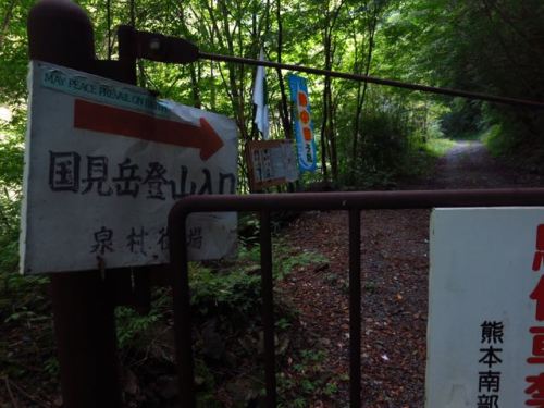
A path leads straight up the slopes and parallels the ropeway ruins, and it is this concrete path that I used on my first trip to the volcano, but during that time I became intrigued with another route called the Sensui-one spur that climbs a steep ridge just under the Takadake high point. It is along this route that Alastair and I now turn our attention. The trailhead entrance lies on the opposite side of the car park, marked with a small wooded bridge spanning the Sensui ravine. Along broken bits of concrete we initially prance, followed by a narrow path recently cleared of underbrush. The start of the spur is soon reached, offering a refreshing bit of rock-hopping along the weather-beaten pumice.

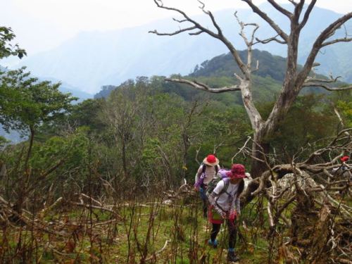
A generous lathering of yellow arrows delineates the route, but in the overcast autumn skies we can clearly trace the path all the way up to the summit plateau towering 600 vertical meters above. As we climb higher, the vistas across the valley behind us open up to the Kujū mountains rising majestically out of the fertile valley. A giant white stupa constructed near the trailhead feel distinctly southeast Asian, perhaps even Burmese in nature if someone would be kind enough to bring a truckload of gold paint.

Alastair and I make good work of the spur, powered by a self-imposed race against the volcanic gods. One sudden tremor or plume of steam on the horizon would mean a sudden abandonment of our climb and a quick scramble for shelter. Loitering on an active volcano is something that no one should do unnecessarily, so while our plan is to enjoy the hike, we keep the pace brisk and the rests brief.

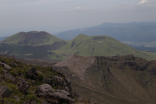
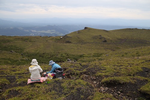
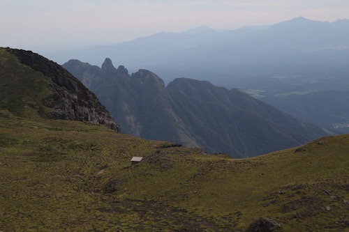
It takes around 90 minutes to reach the Takadake crater rim – stretched out before us is an older, dormant crater lined with verdant grasses and affording stellar views across to Mt Sobo and Mt Okue to the east. Crisp autumn winds push in from the north, keeping us moving up the final few steps of the pyramidal form of Takadake. A few dozen other hikers lounge around on the summit, while the buzz of a drone pierces the still air. At least the lack of tranquility will (literally) keep us on our toes.

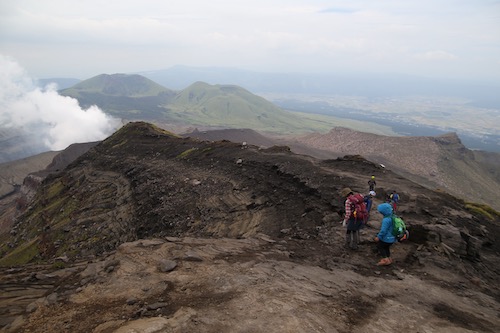
We pick up the track down to a saddle below Nakadake, where the gentle gradient brings thoughts of the Scottish hills to mind. The route takes us towards the active crater of Nakadake, which seems a bit like slipping out of the frying pan and into the fire, but an unforeseen force attracts us towards the pillar of steam billowing from the giant crater.

Continuing south, the first signs of the eruptions present themselves, as the entire landscapes takes on a tinge of brownish-gray dust, staining the signposts as if crafted by a spray gun artist. We are now within the 1km strike zone, an area that no other hikers have visited apart from the several dozen other trespassers staring in goggle-eyed disbelief.


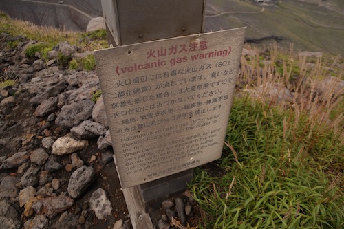
The track drops to a narrow saddle and climbs to an overlook uncomfortably close to the active crater, but we push on, spellbound and transfixed like a veteran rubbernecker. Gazing directly down into the hissing crater, I wonder how long it will be before this vista will once again be off limits to all but the most dedicated volcanic researchers.

I turn around and trace my eyes up along the ridge we had just traversed, with the top hat of the Nakadake summit teetering on the edge of the abyss.  A pair of concrete bunkers sit just off the ridge, partially collapsed by the force of the series of powerful eruptions. While these emergency shelters offer protection from small stones, a cataclysmic eruption of the crater would perhaps allow you enough time to send a farewell text to a loved one.

A concrete path used to run from here to the top of the ropeway, but now it is nothing but the remnants of rain runoff with bits of cement piercing through the fresh layer of ash. We reach the top of the ropeway ruins, a structure that would probably have received less damage had it actually been hit by bombs. Perhaps the Nakadake crater showed its discontent by trying to wipe this eyesore off the face of the earth.

Luckily for visitors, the ropeway ceased operations in 2010, meaning no one was actually in the structure during the series of volcanic explosions. While this building may seem like a wet dream for the haikyo hunters, visitors are advised to stay well clear of the incredibly unstable structure, which seems hellbent on collapse with nothing more than a strong gale.

The concrete path that runs alongside the ropeway is slowly being taken by the forces of nature, making the path rather pleasant among the tufts of greenery swallowing the remaining remnants of surfaced walkway. We follow a handful of other hikers down the rolling slopes towards the parking lot.

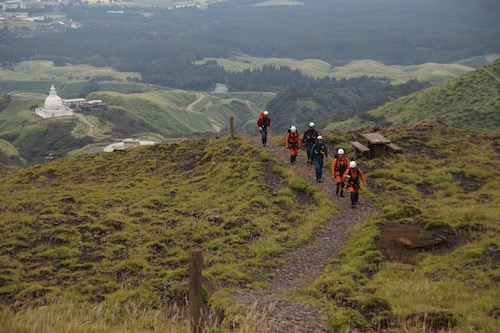
It would make for a peaceful end to our hike if not for the thumping crescendo of an approaching helicopter. The chopper heads above the summit of Takadake, where a lone figure is winched down to the ground. In conjunction, a sextet of rescue workers ascends at a brisk pace to offer back-up. The lead is connected via radio to the chopper team, who are in the midst of a rescue operation. We give way to the team, offering words of encouragement for what will likely be the first of many missions on this busy holiday weekend.

Once back at the car, we final exhale a sigh of relief. Alastair can now count the remaining Hyakumeizan on one hand and now has everything west of the Japan Alps off his list. Just one peak in Hokkaido, one in Tohoku, and a trio of peaks in the South Alps stand between him and his goal of finishing the 100.


Read Full Post »

Climbing the highest peak in every prefecture wouldn’t be easy, but with a little help from my friends it could be a little less intimidating. The previous day, in less than desire downpours, I had knocked off the highest mountain in Okinawa along a trail slippery with runoff and heavy with erosion. While hardly a monstrosity, the mountain did throw up some surprising challenges that took the form of habu snakes lurking in the shadows of the dense jungle floor. As I recovered in the common room of a guesthouse in Kabira bay on Ishigaki island, a young, brightly attired guest entered through the vestibule, dropping her sky blue Millet pack next to the other luggage tucked away in the far corner of the cozy space. She took a seat around the low, rectangular dining table and settled into our lively conversation. She appeared quite different from the other half a dozen beach-bumming guests of the penny-penching accommodation, her dark wavy locks tucked neatly under a red and beige Outdoor Research sun hat.

kunimi2

She introduced herself as Megumi from Kumamoto city, and the conversation quickly shifted to the mountains, a subject that both of us shared with equal passion. We spent the rest of the afternoon and evening engrossed in conversation about past hiking trips and future endeavors. After explaining my dream of climbing Japan’s prefectural summits, she invited me along to climb with a few of her other outdoor enthusiasts to Mt. Kunimi, the highest mountain in her prefecture and included on the list of Japan’s 300 Famous mountains. A chance to knock off another peak in Kyushu was too much to pass up, so a few months after our fateful encounter I cruised through the rice fields on the newly-christened Kyushu Shinkansen en route to the old, hilly castle town. I had been to Kumamoto once before for a brief stopover between the mountains of Unzen and Aso, but here way my first chance to see the historical town through the eyes of a local.

kunimi1

After checking into a cheap guesthouse that doubled as a gourmet coffee shop, Megumi dropped by to shuttle me to a local restaurant to get acquainted with our climbing team. We squeezed into a cozy table in the corner of the bustling establishment while my host fired off food orders to the sure-footed staff. Megumi settled in beside a dark-haired guy with thick eyebrows and a million dollar smile that would surely make even the thickest girl swoon. He introduced himself as Tsubasa, a pharmaceutical researcher turned part-time mountaineer and photographer. He knowledge of alpine routes was stunning for someone dwelling so far from the loftier heights of Honshu. It turns out he was born and raised in Shiga Prefecture near the shores of Lake Biwa, a fellow Kansai partner with a thirst for adventure as satiated as my own. On my right sat a cute, bubbly girl by the name of Keiko, whose small face, dark complexion, and straight brown hair seemed more southeast Asian than the ghostly complexion of typical citizens of the rising sun. Due to the warm climate and ample sunshine, the women of Kyushu take on an exotic air and vibe that are enough to drive a grown man crazy. Despite the pheromones permeating from our companions, Tsubasa and I stayed on our best behavior, lest we draw the ire of our significant others.

kunimi7

I had a difficult time sleeping that evening, a combination of the hormones released in our lively dinner and the remnants of the strong cappuccino still flowing through my throbbing blood vessels. Tossing and turning on the firm mattress in the deserted guesthouse, I focused on the impending climb of the 1739-meter mountain, a peak I knew next-to-nothing about. At least it appeared in Tsubasa’s Kyushu hiking guidebook. Thoughts of weather conditions dominated, as most of my summer ascents on Japan’s southerly island have been anything but cooperative. Eventually I drifted off into a deep, drooling, comatose state but was jerked out of my slumber by 6am morning call.

kunimi3

Tsubasa’s red hatchback rolled up around 7am and I settled into the backseat alongside Keiko. Megumi helped Tsubasa navigate through the rural hamlets of the Kumamoto countryside. The rural route followed the narrow valleys of the southern part of Mashiki village, an area dominated by ancient tile-roofed structures still clinging to their feudal past. The road nudged just past the vestibules of these rustic buildings, the road built directly atop the old horse trails that once linked these secluded hamlets to their pre-Meiji daimyo lords. Occasionally we’d grind to a halt as a hunchbacked octogenarian crossed the road with the speed and agility of a box turtle.

kunimi5

Out of the valleys we rose, along windy mountain roads barely wide enough to accommodate one-way traffic. Whenever a vehicle approached from the opposite direction we’d put the car in reverse, searching for the slightest shoulder that would give us a few extra inches of leeway. Luckily the traffic was few and far between and once over the mountain pass the byway widened to a more respectable span. Speaking of spans, a bit further up the valley we reached an immense suspension bridge crossing a nauseating drop down to a river covered in thick, green foliage. We vowed to cross this pedestrian walkway after our hike, as we needed to head back this way upon our return to Kumamoto city.

kunimi6

Just past the bridge we left the comforts of the prefectural highway and inched up a gravel forest road in a sorry state of disrepair until reaching a large gate permanently bolted shut. A gnarled metal signpost pointed the way to the trailhead of Mt. Kunimi, so we shouldered the packs and I led the way, using my GPS for guidance. We soon passed the old trailhead with a hand-painted sign indicating hikers to use the newer path a further ten minutes up the shuttered road. It was after 11am when we our first footfall hit the soil of the overgrown trail. but we pushed on with determined drive through a forgotten thicket of planted cedar that rose straight up the spur without a single switchback. Using both our hands and feet for purchase, we literally crawled up the mountain like lions on the hunt for antelopes.

kunimi8

Fortunately we soon reached a junction where the old trail met up with the main trail up the mountain, and the angle eased somewhat, the evergreen army yielding to a healthier and more diverse forest of aged hardwoods and beech. We picked our way over, under, and sometimes around a collection of felled trees blocking the path at regular intervals. No one had come along to do trail maintenance in quite some time, but despite the physical hindrances we made remarkably good time up the spur towards the ridge.

kunimi4

The forest thinned out once we breached the 1500 vertical-meter mark, replaced by patches of wild grass punctuated by shards of granite rock anchored in place by towering columns of beech and hemlock. We climbed in a unison of smiles and delight, spellbound with the stark beauty of an island otherwise dominated by active volcanoes. Indeed, this mountain range seemed out of place, as if transplanted here from Shikoku by Izanagi in a fit of jealous rage.

kunimi9

The spur eventually converged with the north-south ridge trail, marked by a sign indicating that the summit was only a five minute stroll away. So much for a leisurely walk along the ridge. A full traverse of the range is a preferred alternative to our rapid up-and-down assault on the mountain. The vistas towards neighboring Mt. Eboshi were blotted out by a bank of cloud, but through gaps in the mist to the north we could catch sight of the peaks of Miyazaki Prefecture. In fact, we were sitting directly on the border of the two prefectures, though Mt. Sobo, just twenty meters higher, lays claim to the highest point in Miyazaki.

kunimi11

Under a cool, refreshing breeze we enjoyed our boxed lunch and shared our love of Japan’s mountains. My companions were all surprised to hear that I had finished scaling all of the Hyakumeizan and that I was attempting to touch down on the highest point of every prefecture. Their faces beamed with delight upon the news that the highest mountains of Saga and Fukuoka were still on my to-do list. “Let’s do them for sure,” claimed Tsubasa. It was here that I realized with the proper support and encouragement, these 47 mountains could indeed become a reality.

kunimi10

Keiko spotted something out of the corner of her eye, injecting a single word into our jubilant conversation that had us craning our necks for a view. “Mogura“, she shouted, pointing in the direction of a nearby rock formation. We turned around just in time to see the elusive Japanese shrew-mole poke its head out of its hiding place before ducking back down for cover. It was my first and only time to see the primarily noctural animal up close and personal.

kunimi12

Only when the clouds moved in and completely blotted out the views did we reluctantly retreat back to the warmth of the forest canopy. Instead of heading directly back down the way we came, we opted for the left fork along the old trail that was marked as “dangerous”. True to form, the path petered out at the top of a rocky precipice with no clear way down. Backtracking a bit, we dropped off the ridge and opted for the cedar plantation. We carefully picked our way through the maze of toppled trees, trying to halt the pull of gravity against our fatigued bodies and minds. It was sweaty, exhausting work, but eventually we did pick up the remnants of the path at the bottom of the cliffs and dropped back down to the forest road. Future hikers would be best served by heeding the warnings and sticking to the safety of the newer path.

kunimi13

As promised, on the drive back we stopped off at the suspension bridge to stretch the muscles and to test our acrophobia. The bridge swayed under our weight as we bounced uneasily along the concrete footbridge. It was all in good fun, but we definitely knew that it would not be a good place to loiter in an earthquake. Fortunately, such seismic events were still a few years away from becoming a horrifying reality. As news of the powerful temblors reached the masses, the first people I contacted were my trusty trio of Kumamoto companions to make sure they are ok. With such devastating destruction, I fear that it may be quite some time before another hiker is allowed the privilege of setting foot on the roof of Kumamoto, and for that I feel both lucky by our timing and heartbroken by this new reality.

Read Full Post »

After the ferocious winds of Kuju, Kanako and I were ready for a break. The town of Yufuin willfully obliged, offering organic smoke-free cafes, creatively designed art museums, and cobalt blue thermal baths. Just what we needed to rejuvenate the mind and body for the impending second bout with Mt. Yufu. Would the weather finally clear?

Early on the morning of the 27th, we awoke to a rare sight in northern Kyushu: a cloudless sky. Even our target peak remained suspiciously free of white mist. Our climbing window had just opened, but for how long we knew not. The bus shuttled us to the trailhead at the reasonable start time of 9am. We weren’t taking Yufu lightly this time around.

The golden meadows at the start of the hike glowed sweetly in the early morning light, framed nicely by the white-capped rocks of Yufu’s impressive edifice. We steadily weaved through the forest, enjoying the quiet sounds of nature away from the crowds. Once we hit the trail junction, the 42 switchbacks began, but Kanako and I marched triumphantly towards the treeline. Good weather makes everything better.

The crater rim was reached shortly before 11am, and we faced our biggest challenge: snow-covered rock faces. I laid the question on Kanako quite frankly: “Which peak do you want to climb first, the easy one or the intimidating one?”. The reply came as swiftly as our advancing climb: “The intimidating one, of course”.

By now a few other hikers had made their way to the junction, but only one other brave soul followed our pursuit of the west peak. Luck was definitely on our side, as the warm temperatures had melted the ice on the tricky footholds, making the ascent a little less deadly. It was still just as intimidating as the first time around, with the added hurdle of actually being able to see the vertical drops on either side of the jagged ridge.

Once out of the chain-laden vertigo zone, the final coast to the high point was absolutely breathtaking, with uninterrupted panoramic views in all directions. We took a quick summit snap before retreating back to the junction for our lunch break. For, as beautiful as the summit was, there was no place to sit without being enveloped in snow and mud.

Yufu’s smaller twin, the east peak, towered mightily above as we navigated the frozen switchbacks of the northern face with great caution. Even though our first peak was more technically challenging, we had our own work cut out for us kick-stepping safe footholds in the ice. Once on the ridge, the sun aided us in the traverse, thawing the remaining patches of frozen rocks just below the peak. Again, we took a quick summit shot before strapping on the crampons for the harrowing descent through the ice field. Others had started edging their way up the frozen path without the added assistance of climbing irons. Kanako and I made a rule of carrying our crampons on any hike between the months of October and May. Lessons learned from being caught off-guard too many times in the past.

Once safely returned to the junction, we flew back down to the treeline, passing a group of 14 rather attractive young females led by an elderly guide. Perhaps the hiking boom among the 20-something crowd isn’t such a bad thing after all.

Our next goal for the day was the conical summit of Iimorigajou, which was knocked off after a short 20-minute climb. We tried resting on the summit but the winds had picked up considerably, dropping temperatures down to the freezing point. “Hot spring?”, I suggested. Kanako rose with renewed vigor upon this suggestion and literally flew off into the golden fields towards Takemoto.

This section of trail had seen much better maintenance than my initial trip there, with new signposts and a welcome trimming of the grass. Yufu’s twin peaks stared down at us as if to yelp out a friendly greeting, yet they seemed so daunting. Had we really been up both peaks earlier in the day?

Once we entered the forest, the lure of the hot springs became too much to bear, as both of us picked up the pace. We hit the town around 4pm, grabbed a quick bowl of udon, and dropped by for a soothing soak on the way back to the hostel. Mt. Yufu truly showed her gentle side on our successful mission, and we both knew how lucky we were to visit on such a rare occasion. Now, if we can just convince our nemesis Mt. Kuju to be just as cooperative…

Read Full Post »

Mt. Yufu soars majestically from its base at the scenic hot spring town of Yufuin, rightfully earning the nickname of Bungo Fuji by pre-Meiji era pundits. Cloud clung tightly to the twin peaks on the summit as I munched down on chicken tempura in a eatery next to the bus terminal. I boarded the 1pm bus for the trailhead and hoped for the best.

The first part of the trail tramped through a vast meadow of lush green hay, with views of Yufu’s mighty figure directly ahead. If it weren’t for the clouds the peak would look even taller than it currently stood, hovering over the meadows like a volcanic version of godzilla. Intimidating it was in the afternoon breeze.

After the meadows the trail slipped into the forest, past an old toilet block and into a thick canopy of deciduous trees, which sheltered me from the rain that began to fall from the sky. Here I was without any rain gear and faced with a dilemma: turn around now and have a second go at Yufu the following day, or tough it out and see where it takes me. I’m always a fan of spontaneity so it was obvious which option I chose.

The rain let up a bit after reaching the junction at Gouyagoshi, where half a dozen Self-Defense Force soldiers were looking over a map. “Be careful up there,” explained the leader, “the summit rocks are slippery.” Apparently they were speaking from first-hand experience, as I later found out that the peak is a popular training ground for the unit stationed at the nearby military base.

Up through a maze of switchbacks I scurried, looking for the safest way up to the summit, which was fairly easy since there was only one way to the top. As I reached the treeline, the precipitation halted completely and the sun poked its head through the clouds. I knew then that I’d made the right choice, with ever expanding views revealing themselves with each advancing step.

Just before the crater rim I disappeared into the clouds, resting at the junction just below the twin peaks. I had two choices: either the straightforward climb on my right to the top of the east peak (Higashi-mine), or the no-nonsense scramble on my left to the official high point of the west peak (Nishi-mine). When in doubt always head west my dear.

I soon found myself standing at the bottom of a long series of metal chains. “So this is what those military guys were on about,” I cursed, gripping the slippery silver links with my left hand. The path was quite slippery and here I was all alone in a tempest of white cloud and strong winds. After the first challenging climb, the path dropped to another set of boulders, where a tricky horizontal traverse awaited. I’ve done my fair share of frightening climbs in the Alps but I must say that this one really made the hairs stand on on my legs. Heart pumping, hands shaking, I grabbed the links, spinning 45-degrees up and over a sheer vertical drop before finding my footing on the other side. One slip here and I would most definitely need to be airlifted out.

Yufu relented a bit after that challenging scramble and I soon found myself sitting on the high point of the volcano. I snapped a quick photo before retracing my steps back through the labyrinth of chains, which were even scarier on the descent. I collapsed back at the junction in a heap of sweat and adrenaline. On the way back down the mountain I started counting the switchbacks, only to be met by a Japanese couple on their way up to the peak. It turns out the husband-and-wife team were also counting the switchbacks, but their numbers were surely off. I think they were counting a 360-degree change of direction as one complete switchback instead of the usual 180-degree turn. Anyone want to shed light on which on is correct? I counted at least 40 different changes of direction in my 20-minute jog back down to the base of the peak.

Once back at the junction where I’d met the Self-Defense men, I tried my luck at climbing the grassy cone of Iimorigajou, a short but incredibly steep climb just south of the restpoint. As I stood among the fresh greenery, admiring the bird’s eye views of Yufuin in the valley below, I raised my hands in sheer joy: it doesn’t get much better than this.

On my map, I spied a trail back into town which did not require the assistance of a bus, so westward I continued on the aptly named western trail, which weaved through the stunning grasslands as trails in Scotland are apt to do. I truly felt as if I were suddenly transported to a different climate, snaking smoothly through the overgrown pastures like a shepherd searching for its lost flock.

By the time I reached the forest it was nearly 5pm, so I quickened the pace, arriving in town a short time later. After a quick bath at the thatched-roof waters of Shitanyu on the shores of Kirinko, I strolled through town back to the train station, just in time to meet the hostel proprietor, who drove me to my waiting accommodation. Mt. Yufu was incredibly impressive, but I knew that I must return to see the summit views unobstructed by cloud formations. I knew winter afforded my best chance for that opportunity.

Read Full Post »

Rule #1 of the Hyakumeizan Revenge club: never attempt revenge on a peak you had perfect weather the first time around. Rule #2: same as rule #1. So what were Kanako and I doing here, standing at Makinoto-toge in the middle of a blizzard on Christmas day?

After a grueling 3-1/2 bus journey from Kumamoto, we dropped off all unnecessary gear at the souvenir shop, strapped on the crampons, and headed up the frozen volcanic tundra towards the ridge line. We passed by groups of properly attired hikers making their way off the cloud-covered plateau. None of us had snow pants, since we weren’t expecting Hokkaido conditions on Japan’s southernmost island. Still, the White Christmas was a welcome change to the usual concrete of an Osaka winter.

Once we reached the top of the mountain pass, a problem immediately came clear: our water was freezing! We’d brought along a liter between the two of us, plus a half a liter of hot tea and hot water, both kept in a separate thermos. It was definitely well below freezing up here, and visibility was quite poor. Still, we pushed on like two camels walking through a desolate desert in search of shade. Our shade in this case would be a place to shelter from the wind.

The snow was some of the driest powder I’d seen in some time. The sugary grains blew swiftly and easily through the gale force winds, leaving the ridge a nasty mess of frozen volcanic rock. Even with crampons it was slow going, for one false step would mean a turned ankle and no means of rescue. We reached the col below the summit of Mt. Hossho in desperate need of nourishment. My lungs felt as if someone had been sitting on them all morning, aching with each inhalation. Sitting in the middle of the trail, I reached for my thermos, realizing to my horror that the warm water I’d needed had long since turned cold. Kanako brought out her thermos, offering sips of steaming tea. The lungs began to function again.

Sitting on the col, the clouds began to break, revealing spell-binding views of Mt. Kuju’s pointy summit. The altimeter read 1660 meters. If only we could spend a few more hours out here, I thought. The lunch we’d brought froze over as well, as I forced some nuts into my wiped out body. We’d set a turnaround time of 2pm and it was already a quarter past 2. There’d be no more climbing if we had any chance of making the 4pm bus.

Bravely, we made a 180-degree turn back towards Makinoto pass. This time we were feeling the full brunt of the head winds. In addition to the fingers and toes, the knees were the next body part to lose feeling. We needed to get off this mountain and fast. A quick glance at the thermometer revealed the sense of urgency.  Minus 20 degrees centigrade. Were we really on the island of Kyushu?

Despite our obvious predicament, Kanako was absolutely enjoying herself, stopping every few minutes to admire the hoarfrost and gradually improving views towards Mt. Aso. “Let’s do more snow climbing”, she demanded, immune to the arctic winds and cold air sensitivity that was impeding my cardiovascular system.

Arriving back at our starting point around 3:30pm, we slipped back into the souvenir shop, ordered a coffee, and stood in front of the kerosene heater trying to bring feeling back into our appendages. The warm interior was most comforting, especially since a fresh squall was once again dumping fresh snow on the hills. Looks like we made it off just in time.

Even though we couldn’t reach the summit, the mission wasn’t a complete failure. After all, few other people would have made it as far and as long as we did with the same resources at our disposal. Next time I’ll remember to bring the snow pants and eat my lunch before starting the hike. Kuju deserves a winter rematch and victory will be ours, rest assured.


Read Full Post »

Excitement filled the air as the ferry pulled into Beppu port. Blue skies, calm winds, and the final unscaled Hyakumeizan in Kyushu lie just over the hills in the southern part of Oita Prefecture. Kanako and I jumped on a train bound for Taketa station, where a taxi happily drove us to Kamihara, a collection of decrepit houses marking the entrance to the northern face of our target peak.

Mt. Sobo, or grandfather mountain as the Chinese characters imply, is hardly an old man’s peak, rising abruptly over 1000 vertical meters from our present vantage point. Little did we know what other obstacles the old man was about to unload on the unprepared explorers. First, there was the stifling humidity of a July in the southern island. We were still on the cusp of the rainy season, with gallons of sweat rolling off our weary bodies. By the time we reached the unmanned hut at the 5th stagepoint, a change of clothing was in order. We rang out our drenched shirts in the thick air, replenishing our lost fluids with H2O from a neighboring water source. After a leisurely break, we regained the will to gear up once again and crawl up towards the ridge line.

It was in this next stretch of trail where my lexical knowledge was abruptly expanded. Swarms of black, bee-like flies hovered over our stenched torsos, attacking any exposed skin with unreserved vengeance. Yes, the almighty Japanese abu. Horseflies are surprisingly scarce in the mountains of Kansai, but they reign supreme in the forested peaks of Kyushu. Kanako and I pushed on, despite desperately needing a rest from the excruciatingly steep slog. Every time we stopped the flies would inflict their painful blood-sucking bites.

Alas, we somehow managed to reach Kunimi-toge, where the foundation of a rather large hut lie concealed under an overgrown lawn. The map had this place marked as a campsite, but with no reliable water source and the abundance of abu, we had no choice but to push on. The thick cedar forests gave way to native flora in the form of tall bamboo grass, which thankfully kept the horseflies at bay. We could finally slow up our pace, admiring the lush greenery under the deciduous canopy. After a handful of ups-and-downs Kanako and I reached the emergency hut at the 9th stagepoint. Dropping my incredibly heavy pack, I washed my face at the nearby stream, sucking handfuls of the crystalline water deep into my abdomen. Kanako collapsed on the stone bench, while I assessed the situation. Even though I’d brought the tent, we had a free roof over our heads and no one else around to bother us. Even the hut warden was away, leaving an honesty box to put the modest hut fee in. Life was good.

Lunch was cooked and devoured before we raced up to the rocky summit of Mt. Sobo. The sun shined brightly while the surrounding peaks were covered in thickening cloud. The haze concealed Mt. Kuju, the highest peak of Kyushu but at least we weren’t sitting in a world of white. Kanako took a nap while I observed the butterflies sunning themselves on the rocks.

Over an hour we spend on that bald summit, soaking in the sounds and feelings of nature. We seriously considered bivvying directly on top but had no extra energy to drag the gear up from the hut below. Eventually we slithered back our awaiting kit, trying to make that all-important decision of where to sleep. “I want to sleep outside,” demanded Kanako, deeming the hut too dank for her taste. Indeed a strong musty odor wafted from the worn blankets, and the lack of ventilation was disconcerting. Studying the map, I found a campsite marked at Miyahara, a 45-minute walk from our current position. The boss nodded in the affirmative when I offered this alternative.

Heavy gear on once again, we dropped down the steep trail, away from the comforts of the hut. It was already approaching 5pm, and the winds had picked up quite significantly. Suddenly, as if on cue, a rumbling sound rose forth from behind. Was that thunder I just heard? I turned 90 degrees, noticing the black clouds rolling over the lofty peaks of Sobo. Our lazy stroll was abandoned in favor of a hearty trot, as the tempest was likely to overtake us at any moment. The rumbles grew louder and louder, just as we reached the 3-way junction our of intended goal. Here, directly in the center of the trail, lay a flat area no wider than one tent width. Whether this were the official campsite or not I would never know, but it looked heavenly by our standards. I literally ripped the tent out of my pack, setting up camp in just the nick of time.

Kanako and I crawled in, while the rain poured violently all around us, a reminder that the rainy season had yet to release its grip on the archipelago. “Perhaps we should’ve stayed in that hut after all,” I chuckled to my startled companion. The rain let up after an hour or so, allowing us a chance to fire up the stove and cook a quick meal.

The next morning, the cloud lay thick all around, as we broke down camp and traversed down to the bus stop at Obira. Mt. Sobo had put up one heck of a fight, but victory was ours. With the Hyakumeizan of Kyushu safely knocked off, I turned my attention to the remaining 70 summits on Fukada’s list. Perhaps this was going to take much more time that initially anticipated.

Read Full Post »

The ferry from Osaka to Kagoshima is far from ideal, as it drops you off in the boring town of Shibushi, miles from anywhere and convenient to only the truckers delivering supplies to southern Kyushu. Regardless, I slapped down the money on the ticket counter and boarded the ship for an early winter foray in the volcanic hills of Satsuma Peninsula.

It took nearly an hour to flag down my first ride from Shibushi, but by mid-morning I was well on my way towards Sakurajima, my home for the night. After dropping off my stuff at the rather bleak-looking youth hostel, I hitched completely around the island, stopping several times to see the sights and enjoy the thermal baths. Someday I’d like to make it up the crumbling flank of Minami-dake, but the frequent eruptions make it near to impossible to set foot on the volcano. Instead, I focused my attention further south, towards the conical forms of Mt. Kaimon, mountain #25 in my quest for the almighty 100.

The ferry ride to Kagoshima the next morning revealed an overnight dusting of snow on Sakurajima. Despite its tropical image, Kyushu does in fact receive a sizable amount of snow, enough to close roads to mountain passes and to make crampon navigation mandatory. I’d hoped that Kaimon would remain approachable. The train whisked me most of the way down the peninsula, and I used the thumb to guide me the rest of the way, hitching a ride to the base of my target peak. Mt. Kaimon is as majestic as they come, rising abruptly from sea level to a height of nearly 1000 meters above the sea below, rightfully earning the  nickname of Satsuma-fuji.

The path rose quickly through the silent forest, passing over volcanic rock with views of the azure waters below. Mt. Kaimon has the distinction of being the only Hyakumeizan without a single switchback, as the trail does a 360 degree loop of the mountain before arriving on the summit. A glance at any map will clearly show the spiral route to the top.

© JTB Publishing. All rights reserved

Upwards I pushed through the tranquil environs, not meeting an entire soul until just below the boulders of the summit rocks. Here the ice clung to the rock face firmly as I cursed myself for forgetting the crampons. Luckily the other hiker ahead of me had kick-stepped a manageable route and I quickly followed suit, imitating his movements as best I could. Eventually I topped out on the crater rim and was rewarded with an outstanding view of Satsuma’s crescent-shaped coastline. Yakushima was buried in thick cloud way off in the distance, but the rest of the peaks glistened blissfully in the early afternoon sun. I retraced my steps back towards the foot of the peak, painfully stubbing my toes at one point on a frozen rock. Pain shot up my left leg, but at least I was on the way down instead of up. I knew that the town of Ibusuki would be the perfect remedy for my bruised appendages.

After walking back to the main road, I flagged down a ride with a strange man who I seriously thought was going to rob me and leave me for dead in the bay. As soon I entered the car, he turned the vehicle around and told me we were heading to his house, where he had “forgotten to lock the door.” When we arrived, I gripped my hands tightly on the seat of the car. There’d be no way I’d enter his dwelling without a fight. Alone, he walked to his front door, turned the key, and quickly returned. “Ok, let’s go”, he said. The man was telling the truth after all, but still, the experience left me with a bit of a bad taste in my mouth and the rest of the ride was quite awkward, as he kept calling me his best friend. One bad hitch out of nearly a hundred rides over the last decade is a pretty good batting percentage I’d say.

Only one more peak to climb in Kyushu: the might Sobo-san. This time around I’d need companionship, and I knew just where to find it.

Read Full Post »

The ferry rolled into Miyazaki port bright and early on the cusp of the Marine Day weekend. John and I disembarked, thumbing nearby traffic for a lift to the hills. After a few minutes, a car screeches to a halt and we’re ushered in. We immediately head off in the complete opposite direction, towards Shirahama beach in the southern part of the prefecture. Hitching in Japan is very rarely direct, with most locals taking you under their belt with errands to run or other sightseeing missions in sight. Eventually, the driver pointed us westward, into an intense rain storm that threatened to knock the wipers off the vehicle. We pulled into a lone shop by the side of the deserted road, where the driver talked hurriedly with the owner. “This is my mother’s shop”, explained our guide. “She’ll give you a ride the rest of the way to Ebino Kogen”. Despite our repeated protests, the obedient mom did as instructed, driving us at least 100km out of her way. We couldn’t have thanked her enough.

Camping was looking like a lost prospect in the relentless rain. John and I procrastinated as long as we could in the outdoor bath of the tourist hotel, weighing our options. The guidebook mentioned a cheap rotenburo near the trailhead to Koshiki-dake. John called up the place, reserving two spaces in the cabin. Our spirits were lifted with a guaranteed dry place to sleep. After checking in, we killed more time by alternating between soaks in the milky waters and frisbee in the small but empty parking lot.

The rain continued more or less unabated the entire night. After checking out of our modest accomodation, we donned our rain gear and headed up towards Mt. Karakuni, the highest peak in the Kirishima mountain range. Wetsuits would’ve been much more appropriate attire, as we quickly became drenched from head to toe. Apparently the rainy season was still very much here, but we stubbornly pushed on like two untrained basset hounds searching for food. Somewhere near Shinmoe-dake the rain began to abate, but the cloud hung thick in the humid air. Here we were tramping through some of the most breathtaking volcanic scenery on earth and we couldn’t see a thing.

Up and over the volcanic hills we pushed, reaching the parking lot at Takachiho in the late afternoon. The campground was completely flooded as we once again had to weigh the options. Pitching the tent in the vestibule of the visitor’s center seemed like the most feasible option, until we found the perfect place: nestled in the forest about 50 meters north of the parking lot stood a lodge housing some display cases of indigenous insects. It was obviously built for use by school groups on day excursions, yet remained unlocked as if to beckon us in. We dropped off our gear, leaving a window unlocked in case the park service came by to lock it up for the night. More time was killed with parking lot frisbee, with both of us running for cover every time a vehicle approached. We didn’t want to be seen by anyone, less the park authorities. Once darkness set in, we cooked up dinner and prepared to settle in for the night, when I noticed a peculiar-looking arthropod. It appeared to be a cross between a bush-cricket and praying mantis, and they were everywhere! We tried to kill them off one-by-one, but soon realized it’d take us half the night. Would these mutant creatures bite? We didn’t want to take any chances, so we pitched our tent inside of the hut!

Before settling down for shut-eye, I subconsciously locked the front door of the lodge to keep any unwanted wildlife from entering. Sure enough, around midnight, John and I were both awoken by the beams of a torch outside of the entrance. The unidentified person tried to open the door to the hut, shining the headbeam directly into our tent. “What the..”, we both thought, too paralyzed by fear to move. Who on earth would be snooping around these parts so late at night? I thanked myself in hindsight for locking that door. The person never came back, so we could only ask ‘what if’ questions the rest of our trip.

The next morning, we packed our gear and started the long, steep slog to the summit of Takachiho. Once again, the cloud hung heavy and the wind threatened to sweep us into the crater of what I’m told is a very impressive volcano. We fearlessly pushed on towards Higashi Jinja and the bus stop at Haragawa. After dropping down to the river bank and dam, the sun finally decided to rear its ugly head, 40 hours too late in our opinion. Once hitting the main road, we stuck out our thumbs again, this time catching a ride with a friendly middle-aged women driving alone through the mountains. We wanted to go to the beach, any beach, and had absolutely no idea how to get there. “I’m a cop,” confessed our driver. “Let me call up the boys to ask for advice.” As if this trip could’nt get any more surreal. The phone call went something like this:

“I’ve just picked up 2 foreigners. They want to go to the beach. Which road is the best to drop them off so they can hitch?”

Amazingly, the cop dropped us off at the beginning of route 222 in the town of Miyakonojo. She gave us words of encouragement before driving off into traffic. We waited all of about 10 minutes before another car came to our rescue. A young male out on a leisurely drive, who jumped to attention when being told of our destination. “The beach sounds like a great idea!”, quipped our new friend Kenji. He himself had done some hitchhiking a few years back and knew how difficult it was to get rides. “I know a great beach!” We drove off into the late afternoon light like best friends reunited after a decade abroad. We reached the coast, heading north along the breakwater, until arriving at our home for the night, Shirahama! John and I both looked at ourselves, awestruck to be back at the same beach the first driver had brought us to 2 days earlier. Kenji ended up hanging out with us most of the night, and even drove to the convenience store for us to fetch some beer. We taught him how to throw the frisbee as the fireworks in Miyazaki harbor exploded brightly on the horizon. John and I pitched the tent right on the beach, under a thick grove of palm trees. Life really couldn’t get any better.

The next morning, the sun finally showed its full strength, as the temperature really started to heat up in the tent. After a morning swim, the beach came to life with families, budding surfers, and…..the Japanese Self-Defense Force! Military trucks unloaded scores of muscular men donned in white t-shirts and camo pants, each holding a pair of gardening shears. “Uh-oh..”, John and I screamed, “they’re here to prune the trees!” Despite having several dozen groves of palm trees to choose from, you can guess where they started their pruning. Our vocal protests did nothing to quell them, and they didn’t even have the decency to wait until we’d taken down our tent! The only logical explanation is that the beach owners wanted to make money from parasol rentals. Either that, or the gov’t needed to use up their budget. We beat a hasty retreat back to Miyazaki city, killing time before the ferry back to Osaka.

Kirishima definitely lived up to its name, but I definitely need to get back there to better appreciate the scenery. With the recent eruption of Shin-moe, my quest for revenge may take some time indeed.

Read Full Post »

A short walk from Aso station lies the junction of routes 57 and 212. I confidently strolled over to the intersection, about to attempt the impossible, to hitch halfway across the prefecture to the trailhead of Mt. Kuju, the highest peak on the island. Problem was, there was no direct road between here and there, but I had patience on my side and hoped for luck on the horizon.

Ride #1 came after a sunny 20-minute wait, but it only got me a few kilometers up the road to the junction of route 110. Now there was definitely no turning back, but I stood proudly by the side of the street, trying not to look too desperate. The next ride was a goldmine, as the driver took pity on me and dropped me off at the junction of routes 11 and 442, almost within spitting distance of the trail. The final link in my quest came a short time later, and 5 hours after leaving Aso station, I donned my gear and hit the trail.

The initial steep climb to the summit of Mt. Kutsukake was polished off in about 10 minutes, as I was incredibly happy to be out of the automobiles and up into nature. The sky was a deep azure with the relatively good visibility that usually accompanies akibare weather.  In the distance rose the steam vents of neighboring volcanic peaks as I worked my way along the rolling ridge. I bypassed Mt. Kuju in favor of the high point of Naka-dake, deciding that I could climb Kuju on the way back to the parking lot.

The path skirted the edge of a breathtakingly beautiful volcanic lake before rising sharply to Kyushu’s highest summit. I shared the peak with a few other locals and chatted about the scenery. It seems I’d chosen the perfect day to summit, as the area is usually covered in thick cloud most of the year. Luck was definitely on my side.

A vast network of trails left me with plenty of options, so I was able to return back to the junction of Mt. Kuju via another route. I’m a big fan of doing loop hikes whenever I can in order to help curb trail erosion. Stealthily I rose to the top of Kuju’s volcanic cusp, observing the otherworldly conditions around me: steaming fumaroles, sparse vegetation, and rolling hills as far as the eye could see. It was a good day indeed.

As I made my way back down to the main ridge, I eyed a small group sitting on a plastic sheet just off the side of the trail. The oldest member of the group quickly ushered for me to sit down and join the party, which was well into its second bottle of wine! I politely refused, but could do little else when faced with a paper cup full of spirits. In the center of the group sat a large cake, with the words congratulations elegantly penned across the bottom. No it wasn’t a birthday party. One of the other members had just completed the Hyakumeizan and an impromptu celebration was ensuing. They just about keeled over when I told them I was also attempting the 100 peaks, but sighed with relief when I told them I was only 1/10 of the way done. I couldn’t imagine how many years it would take me to finish the remaining 90, but hoped I could have a party just as enjoyable as this one when I finally did finish.

I bade farewell after downing my obligatory cup of wine and raced back to the parking lot of Makinoto. I was hoping to hitch all the way to Fukuoka, and a fellow hiker gave me an interesting strategy. “Just walk through the area and find cars with Fukuoka license plates. Then just ask them to give you a ride.” I’d never tried this approach before, but wasn’t too confident with my Japanese to attempt this, but the man grabbed me by the arm and became my unlikely sidekick. We approached an elderly couple, and after a quick explanation of my predicament, I sat in the back seat with a free ride to Fukuoka. Little did I know how useful this strategy would become on my remaining mountains.

With the first 2 peaks of Kyushu behind me and winter slowly approaching, I set my sights on Kirishima. Would I be blessed with picture perfect weather, or would the island of fog live up to its name?

Read Full Post »

The train ride from Kumamoto to Miyaji was peaceful in the early morning light. Scores of schoolkids invaded the carriages with a surprisingly calm demeanor, productively feeding the data from their notebooks into available cranial space. I was preoccupied as well, drifting into a reverie about my impending assault on the world’s largest active volcanic crater. The main challenge as usual? How to get to the trailhead.

I walked out of Miyaji station, thumb outstretched on the quiet rural byway. Minutes later, a milk truck on a mission to deliver fresh dairy to local residents pulled alongside, whisking me to the base of the ropeway at Sensui-kyo. The mountain looked much worse for wear: I wondered who’d received permission to desecrate such breathtaking geological wonders with useless, man-made atrocities? Unperturbed, I marched up the concrete path running parallel to the chairlift, looking for the person in charge of this destruction only to find myself completely alone, thanks to the mid-week, mid-autumn timing.

The first target of the day, Naka-dake, was polished off in less than 30 minutes as I veered left towards the high point of Taka-dake. Well ahead of schedule, I settled down on a broad cairn holding up the signpost and visually recorded my surroundings in my sketchbook. Kijima-dake’s Fuji-esque figure towered over the plumes of stem from  Aso’s smouldering active crater, a place worthy of further investigation.

Dropping back to the junction at Naka, I skirt the edge of the old crater, spotting the paint marks that offered safe passage down to the lunar landscape of Sunasenri-ga-hama, literally the beach of 1000 ri (1 ri being the equivalent of roughly 600m). It certainly felt like an eternity marching through the deserted plain, devoid of any sign of plant or animal life as far as the eye could see.  It felt as if I were suddenly transplanted onto the set of a bizarre sci-fi movie, the sulfuric fumes adding to the surrealism.

I pushed on through the plateau, reaching a hard-surfaced road leading to the behemoth concrete structure housing the visitor’s center. Northerly winds pushed the steam and stench due south, smothering the tourists and swallowing the charter buses in the parking lot. Perhaps it was nature’s way of punishing the intruders, or a warning to me for trespassing on her hallowed ash. Either way, there’d be no chance to gaze at Aso’s majestic crater lake this time round.

I quickly retreated down the overbuilt highway, past an abandoned ski resort to the turnoff for Kijima-dake. Up through the grasslands I climbed, circumnavigating the crater rim while admiring the inverted rice bowl of Kome-zuka in the valley below. Once again, no other souls ventured up the peak despite the glorious weather. Back down to the highway I coasted, bypassing the grazing horses and cattle in favor of a safe hitch back to Aso station. With 1 volcano now safely behind me, I laid out a strategy for the following day’s attack on Mt. Kuju. What other obstacles did nature have in store for me?

Read Full Post »