The weather of early April continues to remain stable, offering plenty of opportunities to knock off the next section of the Takashima Trail. If our plan comes to fruition, we can reach the halfway point of our journey and what better way to celebrate this milestone than by inviting along a few extra friends. Cue my faithful Nagoya-based hiking partners Hisao and Haru, who bring along ultra-trail hiker Paul from Hike and Bike Japan. Meanwhile, Kyoto resident Van heads up by bicycle while Ted drives our vehicle to the rendezvous point at Kutsuki Michi-no-eki. After an early-morning discussion of the plan and a quick stocking of rations at the Lawson convenience store, we board the community bus bound for the secluded village of Kijiyama. We have the minivan to ourselves for the 40-minute journey along an incredibly narrow road hugging the banks of the Asao river. We alight in the sleepy village and are immediately greeted by a duo of anatomically-correct stone kappa statues placed in the village in an apparent attempt to trick hikers into falling for their ruse.

We walk along the paved road northwest past a grove of rhododendron that have somehow managed to bloom unseasonably early in the biting air of late spring: perhaps those pesky statues have coaxed those flowers out of their shy buds, Meanwhile, a grove of plum blossoms further on remind us that summer is still quite a long ways off. High above, the greenery is only just starting to return to the mountains after a long, dormant winter. Our road transitions from asphalt to dirt and starts gaining altitude towards the ridge. We follow suit shortly before cross checking our position with the GPS and realize that we have gone off route. We backtrack to where the incline starts and enter a narrow watershed lined with tape marks affixed to a series of hardwoods. I scan the forest floor for signs of mountain leeches but am relieved to find that the chilly temperatures have kept them at bay. In the early morning sunshine we follow the moss-covered stones toward the ridge and our impending return to the Takashima.

The trail keeps to the left bank of the river for the most part, but, like most gorge trails in Japan, ascends high above the river bank past a series of waterfalls before meeting up with the river’s edge further upstream. We exercise care in this section, walking single file while double checking our footholds. One slip here would be an early end to our day.

Haru takes the lead, escorting us past a depilated shelter once used by forestry workers before ushering us across an improvised wooden bridge consisting of cedar logs fastened together with thin wooden planks. The logs bend and bow under our weight but somehow they hold long enough to allow safe passage for everyone. About 50 meters upstream, we cross the river once more among the idyllic waters of the tranquil stream. It is refreshing to find these watersheds untouched by the hands of the concrete industry.

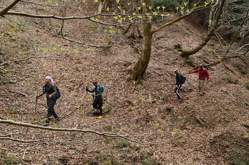
I stay near the rear, making sure everyone keeps pace among our sexy sextet of experienced hikers. Suddenly, I hear shouts from Haru ahead and rush to catch a glimpse of a rather large and bushy brown animal running up the adjacent hillside. Haru and Paul claim that it is a tanuki (a raccoon dog) but without a closer look at the markings I have no way of knowing exactly for sure. From my vantage point it could certainly have been one, but I wouldn’t be surprised if it were an anaguma, a Japanese mountain badger. Unfortunately the creature skitters off too quickly for anyone to gather photographic evidence.
At this next section we struggle briefly to find the tape marks, as they leave the river bed and skirt up the right bank of the river up a steep spur that leads much further upstream towards the headwaters of the Asao river. We walk past a rusted pulley system left behind by some inconsiderate loggers before we ascend a rugged incline to traverse high above the river along a flat trail adorned with fixed ropes. As we walk straight ahead, the river below rises up to meet us and from here to the ridge it is simply a series of negotiable switchbacks.

We reach Kijiyama-tōge (21) at 9:15, just one hour after leaving the forest road. It’s hard to believe I was standing on this exact location exactly 10 days prior. We catch our first glimpses of Mt Aoba between the bare branches of the hardwoods, while the brilliant white petals of the Magnolia kobus glisten in the morning light. A track here drops to the north into Fukui Prefecture, perhaps another route for porters in the olden days to use for delivering fresh fish to the landlocked villages in Kyoto. I explain to Paul and Hisao that a left turn here will lead them to the panoramic views from the summit of Mt Hyakuri-ga-take. Being seasoned trail runners and fast packers, they rise to the challenge, and we all agree to meet up further long the ridge as they will surely soon catch back up with us.

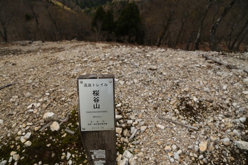
Ted, Hisao, Van and I head northeast along the Takashima up the first slopes of hearty beech trees. Ted and I explain a little about the terrain that we have experienced along the route up this far as they listen eagerly for a teaser of what is to come. It takes us about 20 minutes of steep climbing to top out on Mt Sakuradani (20), the first of several peaks planned for the day. The vistas down to Kijiyama village and beyond stop us in our tracks, as we settle in for a mid-morning snack. I shout across the valley toward Mt Hyakuri, hoping that Paul and Haru will return our greeting, but the distance is too great for our calls to reach them.
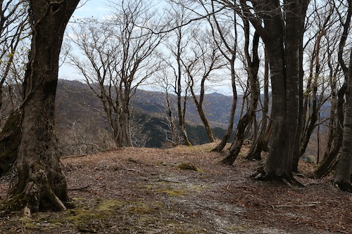
The lime green hues of the foliage beginning to return to the trees brings a sigh of relief that the dull tones of winter will soon be in the rear view. From the summit we head due east, along a bare section of stony ground that affords incredible views of the remainder of the Takashima trail. Directly ahead, the rotund hump of Komagatake stands tall, while further beyond we can trace the foreshortened ridges in the direction of Norikura, our final goal of the section hike. With a bit of luck we can reach it in just four more days, depending on how much of this ridge we can knock out today.

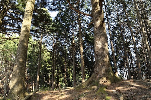
Onward we stroll, transfixed on not only the splendid beauty of the dense deciduous forest but also the jovial conversation about trails, travel, and outdoor gear. It is in these moments of trance-like movements that you really get to know a person, and in our quartet we not only share our experiences but also find time to become absorbed in our own thoughts and observations. To our left, the coastal areas of northern Fukui Prefecture grace us with our presence as if to remind us that we are indeed walking on the central divide. Meanwhile, Lake Biwa beckons us for a peek on our right as the contorted figures of the towering beech trees offer a welcome distraction from our gazing: stare too long out to the horizon and you will certain miss the sheer beauty that can be found right underneath your nose.
We traverse along a narrow section of ridge affording vistas back down to our starting point at Kijiyama. Towering over the village, like a protective watchtower, soars the humpback shape of Hyakuri whose southern face still clings tightly to one remaining snowfield. Here we run into our first hikers of the day, a middle-aged duo heading towards our starting point. After an exchange of pleasantries, the four of us continuing our forward march towards the folds of ridge directly ahead to Komagatake.

At the top of the next rise a hand-painted signpost informs us that we have arrived at peak 765, a common designation for peaks that have no name. The dried grasses provide a soft cushion on our feet as we gently descend to an old pass named Ikenokōchigoe. Apparently in the old days a track dropped off the ridge here to the north to Ikenokōchi village and further along to Obama. It certainly made more sense in the pre-automobile days to take the direct route over the mountains than to detour hundreds of kilometers around them.

The undulating ridge continues on, and the top of the next rise through a grove of towering beech takes up to Yosukedaniyama (与助谷山) (19) and a dilapidated signpost proclaiming that Komagatake is just 2.4km away. While we examine the maps a shout from behind announces the arrival of Paul, who has just spent the last hour running the ridge between Hyakuri and here. As we catch up on our prospective trail stories, Haru also rejoins us as our sextet is now reunited for the final push to the summit. And with such pleasant company comes a truly stunning section of curvy beech trees beckoning us forward.

A dirt forest road runs just below the true ridge for our next little section as our route takes a turn to the north. It is here that Ted and Hisao find out they are both fans of Soul Flower Union and spend the next half an hour engaged in a truly passionate exchange about music. We soon reach the junction for the western ridge course, the escape route that William and I took on our first visit to the peak. I am now back in familiar territory for the next 3.5km and spent most of the final climb to Komagatake telling stories of our battle with Asian giant Hornets during our first visit.

A couple of other hikers are lounging in the sun when we arrive at 780 meter-tall Komagatake (18) a little before 11:30am. We settle in for a well-deserved lunch while taking in the views across Lake Biwa to Mt Ibuki. Ted lounges in the trunk of a sprawling beech tree flanking the northern edge of the broad summit. We share a few snacks between us as we once again stare at the paper map in utter disbelief in how much more ground we have to cover. It is going to be a long afternoon.

We ask one of the other hikers to snap our photo so we can actually have a picture of all six of us together, before we once again shoulder the packs and hit the trail with an added pep in our step. A signpost indicates that our mountain is officially called Wakasa-komagatake to help differentiate it from the dozen or so other Koma peaks scattered throughout Japan. Shortly past this marker I lead the way down a series of log steps that I don’t recall during my first visit to the area. We pause and double check the GPS to realize we have inadvertently taken a spur trail on an adjacent ridge that eventually leads to Kumagaya Juku on the old Saba Kaidō. We backtrack and turn left for the correct track that leads due south over Komagoe (17) and through a series of Magnolia kobus flowers in their brilliant shade of shiny white.

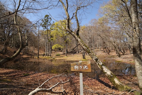
The ridge continues to ebb and flow as we pass right by the gigantic beech tree that was smothered in giant hornets during my first visit. I for one am happy that the brisk early-April air has not only kept the bees away, but has also foiled any plans for the mountain leeches and snakes to awaken early from their winter slumber. During this next section of track I keep hyping up the brilliant waters of Koma-ga-ike but have set myself up for disappointment as the pond is but a tiny fraction of its mid-summer self. Still, the tranquil waters are worthy of a snapshot or two before we continue our march along the long, long ridge.
After passing by the junction for Mt Ikehara (my entry point during my first climb) I am once again in unfamiliar territory. Rather than cruising along the ridge, we find ourselves on a rather abrupt climb up a steep hill as Paul and Haru set off ahead as if on a training mission. The four of us march behind, a series of profanities erupting from my mouth as my legs are not ready for the sudden call of duty. On the summit of the unnamed and unmarked peak we find both Paul and Haru catching their breaths so we let out a sigh of relief that they find the climb just as tough as us.

Our route flattens out for a bit before a gentle descent turns into a sudden rope-grabbing plunge of altitude to Yokotanitōge (16) at an elevation of 450 meters. It has only taken us 90 minutes to reach this pass situated on a paved forest road—only the second paved road we have crossed since starting the Takashima. With one more major peak to climb today, we settle into a calm but steady rhythm through thick groves of rhododendron that are still a few months away from flowering. The waxy leaves are a refreshing site after the high canopy of soaring beech groves.

We soon find a signpost signifying that our final peak is just 1.7km away and the steady climb takes us just 45 minutes to reach Gyōjayama (15) among a shaded grove of cedar. “Cappuccino time,” I announce, as I toss a Koda energy gel over to Ted while the others look on with interest. Unfortunately I have not packed enough of the gels for everyone in our climbing party, but since Ted does have the car keys and is the one accompanying me on this Takashima journey, I know where my priorities lie. Paul occupies himself with trying to repair the broken summit signpost but soon declares it a lost cause, which is what we will all be if we don’t start making a move.

Ted and I, fueled on by the caffeine coursing through our veins, shoot out ahead of the others. We are expecting just a gentle descent to the main road, but our route sends us north over a series of rolling summits with plenty of elevation gain and loss between. This leads us to an undulating ridge of mixed conifer and beech, past a giant fir tree and under a massive electrical pylon before commencing one one final knee-knocking descent to reach a paved road. At last, with flat, easy ground to walk on, we coax to the finish line on route 367. Well sort of, for we still have 5km to walk on the busy road to reach our car at Kutsuki Michi-no-eki. However, I have hatched up a plan.
Once we reach route 367, Ted and I head further up the road toward the junction of Sakura-tōge (14). It’s kind of ironic that the actual Takashima Trail involves a short section of road walking before ducking back into the mountains, but all long-distance hiking trails in Japan require you to walk on a road at some point, as the country is too small and overdeveloped for large sections of wilderness to remain untouched. Anyway, Ted and I have no intention of walking 5km back to our car. We find a section of road with a broad shoulder and I fish the handmade cardboard signboard out of my backpack, a sign that I had made it the previous day in hopes of hitching a ride back to the car. It was time to put it to the test.

The first car swooshes by like we aren’t even there. The second car, however, comes to a halt about 50 meters in front of us as Ted and I trot up to find the driver ushering us toward the back seat of the minivan. We slip on the facemasks and head south on route 367 towards our car. Our ride soon catches up with our companions walking single file on the road. Ted rolls down his window and explain that he will retrieve his car and come pick everyone up. Paul catches word of this and decides to race Ted back to the Michi-no-eki. Our ride drops us off at Ted’s car and I head to Lawson for a cold drink while Ted speeds up the road to pick everyone up. I return to where Hisao’s car is parked and rest in the shade, rehydrating my body and stretching my tired legs. All of a sudden, I hear someone yelling “Wes” and look up to see Paul jogging the last few meters to Hisao’s car while Ted swerves the car into the parking lot. Paul has won the race against Ted’s racing automobile.

It is an unforgettable hike and a most fitting way to celebrate the 50% mark of the Takashima. With a little under 40km remaining, the light at the end of the tunnel is now in sight. Can we hike the next section before Golden Week?
