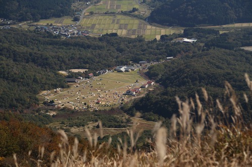
Fueled by the momentum of Day 7, Ted and I head out on the backroads to Makino exactly a week later, under perfect azure skies and a stable high pressure system. This time around, we play it smart and come armed with two vehicles. Hisao and Yasu are en route from Nagoya and we set a rendezvous point of Kunizakai ski resort, the terminus of the Takashima Trail. Ted parks the car in the dirt parking lot of a shrine about 100 meters from the ski lift entrance and Hisao chauffeurs us to the sprawling lawns of Makino Kōgen.

Hikers mill about, drawn to the blazing foliage above the golden grasses of the plateau. A large SUV pulls into its parking space among a dozen or so other vehicles spread out among the campground lawn as the tent city begins to spring to life. The driver seems content with forking over the 5000 yen fee for a night’s tent accommodation, as the pandemic price gauging continues unabated. Our motley crew of hikers is happy with leaving the car camping world behind as the track ascends a series of log steps and ducks into the forest proper.

I am once again in familiar territory, having taken this route on two separate occasions, but the scenery and beauty of the tranquil forest never fails to impress. Ted, Hisao, Yasu and I chat casually, catching up on life as our track enters a tunnel of lightly tinted oaks beginning to show signs of chlorophyll depletion. Further on, a lone hardwood, ablaze in a brilliant reddish-orange tint sends us scrambling for our cameras. We keep a brisk, somewhat sweaty pace before reaching a rest gazebo, where we shed a layer and rehydrate. Spirits are high and how can they not be when blessed but such stunning autumn weather.

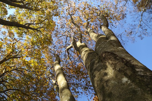
Our route edges us closer to a mountain stream, and once past a small concrete dam we enter the world of the mighty beech. Only the distant view of a giant electrical pylon standing guard on the ridge high above can detract from the natural splendor. As we reach 500 meters of elevation the forests come alive in color. Through long switchbacks, I quiz Ted about his red-green color blindness, intrigued about what he perceives through his ocular filter. While I am spellbound by nature’s brilliant spectacle, Ted sees things through a more muted color spectrum, something that I have difficulty fathoming. Perhaps if you are born with the condition you just learn to live with it. Now, that could work in Ted’s favor, as he wouldn’t have to waste money paying for overpriced temples during the momiji season.

As we inch our way closer to the ridge and the Takashima Trail, we push through the virgin beech forest awestruck by its sheer beauty. Catching the trees before they lose their foliage is tricky, for the leaves turn a brilliant yellow for just a short time before becoming brown and falling to the forest floor in the steady November breezes. While the oaks and maples show off their foliage, the beech have already laid down for winter, but it sure beats tramping through a forest of monocultural cedar. Many thanks go out to the residents of Makino village for not selling their woods to the plantation lords.

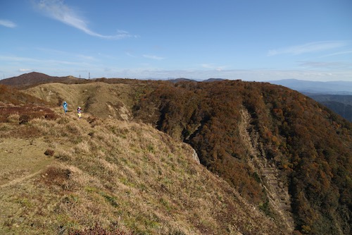
The forest eventually thins as we pass directly under an electrical pylon and onto a broad ridge leading to Awagaragoe (6). A quick turn right and a short climb takes us back up to Mt Akasaka (5) and its brilliant views across Lake Biwa out to Mt Ibuki. Although the 824m peak is already in bare-branch winter mode, the bald summit offers a rare chance to look down upon the autumn foliage from above.

Ted takes the lead as we drop off the northeastern face of the pointy top, drawn to an even bigger peak by the name of Mt Mikuni sitting off to our left. According to the map, the trail does a bit of meandering under the mountain before reaching a junction for the optional climb to the summit. But first, the rock formations of Myō-ō no hage (4) deserve closer inspection.

We scramble among the sandstone boulders through a climber’s playground overlooking the gray waters of Biwa. The sandstone looks as if it’s been poached from the Minami Alps and plopped down directly on the ridge. No doubt a quarry owner or two has stared up at these rocks from below with feelings of greed and envy. After a bit of scrambling, we leave the rocks behind for the shelter and beauty of the forest floor once again.

Our track drops down to a mountain stream, a source of refreshment for thru hikers as the watering holes are few and far between out here on the Takashima. Once again we enter the dazzling world of reds and golds, meander a few serpentine curves, and reach the junction for Mikuni. We turn left here off the main trail and immediately embark on an abrupt ascent up a spine of low-lying trees to the 876m Mikuniyama (3) our high point of the day which we reach at 11:45am, a perfect place for midday nourishment.

On the descent back to the junction, the four of us stare out across a broad plateau and catch a clear view of Mt Norikura, our final peak on the Takashima. The amount of distance left to cover does nothing but make our hearts sink, as it looks like an impossibly long way off on a completely different mountain range. A mountain pass between here and there does offer a chance at an escape route, but for now we hold off on making that crucial decision.

Back at the main trail, we turn left and are now heading due east through a long stretch of wooden boardwalks leading through marshy grasslands of golden hues. Having a bit of flat to traverse is refreshing considering the contours we have just completed. This sense of ease does not last long, however, as the track reenters the thick woods along a knee-knocking descent adorned with fixed chains in some of the steeper places. It’s unfathomable that I had actually considered a winter ascent of Mikuni back in my winter hiking days—it surely would have killed me.

The altimeter drops as we lose a worrying amount of altitude as we finally reach a dirt forest road smothered with slippery leaf litter. To make matters worse, this is not even the main forest road at the pass, for the Takashima soon has us leaving this flat safe haven in favor of a more direct drop through a steep gully that could easily double as a ski run. With burning quads and laughing knees we stumble into Kurokotōge (2). A gravel road here leads down the valley to Shiratani Onsen, and as tempting as that might be, a quick glance at Ted confirms my suspicions that we are NOT coming back for another round. A wooden shelter housing a clean toilet offers us an excuse to rest. After relieving myself, I stuff as much chocolate in my mouth as I can hold, stretch my aching calves, and reach deep within my inner reserves for the strength to take us back up to the ridge high above.

Once again I offer to take the lead as we cross over the forest road and begin our long ascent skyward. I bite my lower lip and push through the tightness in my legs. The initial route through a gully soon merges with a broad spur of healthy beech trees. We step over a collection of scat, most likely ursine in nature as we push our way though the broadleaf dominion. The afternoon light sends deep shadows through the grove, illuminating the foliage like a Christmas lightshow. Such spectacles can do a lot to take your mind off the fatigue.

With spirits high, we reach the crest of a ridge and stop in our tracks, as a signpost clearly indicates that we have an agonizing 3.7km to the summit of Norikura. Not only do we have the debilitating horizontal distance to cover, a scan of the surround hills confirms our suspicions that we have a whole heck of a lot of vertical distance to cover as well. At a place on the map marked as Sarugababa, the trail makes a 90-degree turn and takes us due north up a hillock of susuki grass that terminates at a colossal electrical pylon constructed together with a small hut constructed for the benefit of Kansai electric workers.

The Takashima Trail now merges with a track built by electrical maintenance workers who want nothing more than to traverse the shortest and steepest route to their next electrical pylon along the grid. While rubber steps have been hammered into the hillside, the do nothing to ease the leg pain of weary mountaineers. At every step forward I let out an obscenity, cursing the laziness of the track builders who didn’t even have to courtesy to laid down once single switchback.

As we reach the next electrical pylon the four of us collapse in a heap of sweat and fatigue. I break out the map and realize that we have only progressed about an inch on paper. We veer left and then right, climbing a grassy knoll affording vistas northward to Tsuruga city and the Sea of Japan coast.

The views do nothing to lift our defeated spirits; nor do the sounds of weed whackers as maintenance workers can be seen trimming weeds from the next pylon on the grid sitting further up our impossibly steep ridge. Ted gives the crew the one-fingered salute along with a greeting that rhymes with Truck Foo, summarizing our mood in a nutshell.

With nothing to do but put one foot in front of the other, we march along in silence and climb hillock after hillock chasing those electrical giants.

Up and over three more hills we struggle, hoping for at least a view of Norikura to help lift us from the doldrums, but all we can see on the horizon is a collection of yet more electrical pylons. I can see why 99% of Takashima Trail hikers do this 80km in reverse: they can fly through this mess on day 1 and spend the remainder of their time in the more beautiful sections of trail further southwest. At last we reach a junction for the short side path to Ashiharadake, where we find the purple-suited weedwhackers of Kansai Electric. Ted lets out another profane greeting and rightly so.

Back to the junction and to the south we drop, finally away from the electrical mess and back into the lush beech forests. The contours also finally ease and we are blessed with a relatively flat track to follow as we finally start to gain some horizontal ground. We push through a brilliant grove of giant beech—easily the most impressive collection of trees of the day. Our trail takes us just below the true ridge and past these hardwood behemoths until…..

……depositing us on a paved—yes, you heard that right—a paved road. Bitumen, gracing the once forested slopes of Norikura. Where does this paved road lead, you might ask? Well, to a massive TV antenna of course. Oh Japan, how can you go from giving us such sheer beauty and such shocking development in a matter of minutes?

In a show of solidarity, we avoid the pavement and stick to the grassy shoulder of the broad deserted road. Just below the tower we leave the road, ascend up a collection of fixed metal ladders, and traverse past a second tower and finally back into a more comforting beech forest for the final climb to the summit of Mt Norikura (1). We have finally reached trailpoint #1 on the Trail, a journey that started back in March in northern Kyoto on trailpoint #32.

With no view to speak of, the four of us continue along the trail for just a few minutes until reaching a narrow rock outcrop directly on the trail, which seems as good a place as any for our final break. It is now 3pm and we have been on our feet for 6 hours straight. I throw Ted a Cappuccino energy gel while Yasu fires up the stove to cook noodles. Ted and I roll our eyes as we had hoped to just take a quick break instead of settling in for a second lunch. While Ted and I study the map, devour our gel, and scan the forested slopes below us for a glimpse at the location of our car, Yasu has not only cooked up a bowl of hot noodles, but has already finished eating and is packing away his stove. What we thought would occupy the better part of an hour has taken less than 5 minutes. We stretch our legs for an additional 10 minutes and let the caffeine kick in.

This final stretch of trail I vaguely remember from my first visit, and with the bear spray firmly attached to the belt of my trousers I keep my eyes peeled should the bear from my one and only encounter in Japan reappear. The scenery takes on a familiar tone as I click away, hoping to capture photos that I could not get during my first trip here. The undulating ridge shimmers in the late afternoon light as we set off toward our final descent. There is one last reunion with the electrical pylon and a steep grassy slope to navigate. About halfway down the hill my feet slip out from under me and I end up on my butt, laughing uncontrollably as the electrical workers have exacted their revenge upon us all.

Just past the pylon we leave the ridge for the final time and turn down the eastern face of the mountain. By now we are on autopilot, and with daylight waning we focus our attention on avoiding injuring ourselves on the steep terrain. While the foliage continues to impress, I can do little more than think about the final goal sitting just below us. It takes us the better part of an hour to reach the top of the ski resort, a fitting end to our Takashima dream.

Our journey is far from over, however, as we must now head straight down the top of the ski slopes through a trackless field of sandy grass. My quads scream for me to stop but I let gravity take hold, keeping my peripheral vision on high alert should the bear return. Fortunately, all is well that ends well, as our quartet reaches Arachigoe (0), the official terminus of the trail. After a congratulatory photo, it’s back to business as we reach the car and dusk and embark on the long drive home.

So, was the Takashima worth it? As a multiday hike, it does traverse through some of the best forests in Kansai. However, it would be a lot wiser and less sadistic to do this as a 4-5 day thru hike instead of doing it in sections, in reverse no less, over a series of 8 days. We did more than double the horizontal distance that a continuous thru hike would entail. Here are our stats:
Day 1: 16 km
Day 2: 21km
Day 3: 22 km
Day 4: 23 km
Day 5: 20 km
Day 6: 34 km
Day 7: 17 km
Day 8: 19 km
Total: 172 km (vs. 80km for a thru hike)


