The end of summer is marked in Japan by a seasonal rain front that hovers over the main island each year. Similar in vein to the ‘rainy season’ of June and July, the stationary weather system brings heavy precipitation and unstable barometric pressure, making outdoor pursuits a risky gamble. Regardless, if one wants to knock off a hundred of Kansai’s most secluded peaks, then such dice rolling becomes necessary. With this in mind, Paul and I played the slots and booked a car for a mid-week escape back into the Omine mountain range, and the target this time around was none other than the venerated peak of Mt. Shaka.

Clocking in just under 1800 meters above sea level, the peak is accessible via a long, windy, beat-up forest road buried deep in southern Nara Prefecture. Despite the use of toll roads to escape from Osaka, we still found ourselves crawling along route 168 well past the lunch time bells in search of nourishment. We programmed the car navigation for the michi no eki closest to the mountain turnoff, but were denied a meal because the restaurant decided that Tuesdays were a good day for a holiday. We backtracked, finding a modest noodle shop sandwiched between two narrow road tunnels for a quick meal of udon before continuing the wearisome drive. After finally finding the forest road, Paul carefully navigated the switchbacks while I keep my eyes peeled for falling rocks and oncoming trucks. It was already after 2:30pm when we reached the trailhead, but the clouds remained clear for the time being.
We spent some time sorting through gear, wondering if the tent should be left behind. The map showed an emergency hut nestled in a col between the peaks of Shaka and Dainichi, but the tent would offer more flexibility in case darkness set in before reaching the shelter. Erring on the side of caution, I stuffed the rain fly on the outside while Paul stuffed the poles and inner tent into his 45-liter rucksack. I brought along a liter of water, knowing that we could fill it up at the col just before the final summit push.

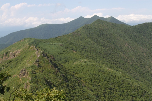
The trail immediately climbed a short spur, with aluminum ladders in place over twisted networks of exposed tree roots. The forest was breathtakingly pristine, with beech, oak, spruce, and other hardwoods growing freely as they had done for centuries. The ridge was breached after an hour of steady climbing, and here the route flattened out, meandering through a maze of bamboo grass and uprooted trees overtaken by gusts delivered by typhoons that frequently lash out at Nara’s highlands. Here and there a hiker or two would appear, questioning our late start and apparent lack of preparation. We don’t really fit the mold of most hikers, ditching the gore-tex and knee high gaiters in favor of short-sleeves and breathable trousers.

We soon met an elderly gentleman pounding a large post into the ground. Even though there was a signpost a few meters away, this self-proclaimed caretaker took it upon himself to erect a new sign on a trail that was virtually impossible to lose. We used this to our advantage, picking his brain about trail conditions and water source locations. He drew us a map in the softened dirt, warning us that the water source at the emergency hut was nothing more than a trickle at times.

A bit further up, a pair of modern day shugenja marched towards us, pompoms bouncing gently against the white tufts of their clothing. The leader was a tall man, no older than 40 if the eyes are to be trusted, carrying a dark staff with the traditional black token affixed to his shiny bald forehead. His companion, surprisingly, was a young woman fully decorated in pilgrimage garb, green pompons dangling from a pale gold sash. The different colors are used to denote rank, and upon first glance the couple appeared to be quite seasoned in the ways of esoteric Buddhism, so I was quite taken aback when the leader pulled out his horagai shell and treated us to an impromptu performance. The instrument is generally used as a bugle call to announce entry to a sacred place and not used as a showpiece, but perhaps these worshippers are a bit more relaxed when not undergoing their solitary shugyō rituals.

We pushed on, rolling across the hilly ridge like two soldiers marching off to war. It was a race against both the time and weather, and the closer we came to the summit plateau, the thicker the clouds became until visibility dropped to only a few meters. Darkness was creeping in, transforming the forests into a scene from a John Carpenter classic. Just after 4:30pm the track widened to a narrow plateau with a few campsites tucked off the southern edge of the ridge. The water source was just above this, so we spread out, keeping the ears open for the sound of flowing water in the reduced visibility of the thick vapor. Paul found it first, and we rushed over to hydrate. The timing was prefect, as I was down to my last 100 ml of liquid.

From here the incline stiffened, with a dozen or so tracks diverging towards the ridge line. It was impossible to tell which one was the correct trail, but the direction was obvious as we only needed to keep heading up. After a twenty-minute shirt-drenching slog, the ridge line was breached, marked by those familiar stone signposts that were erected after the route became a World Heritage site.

Gear was stowed at the junction while we picked our way up the final spine to the high point, marked by a 5-meter high statue of Shaka Nyorai, one of the 13 deities of Shingon Buddhism. I’d forgotten to write down the mantra, only remembering that it began with naamaku, but hoped the deity would at least admire my effort.

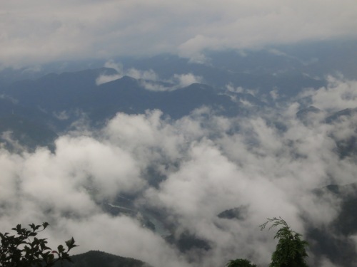
Drops of rain forced us prematurely from the exposed summit, as we retrieved our gear and picked our way slowly across the boulder-strewn ridge. Overgrown bamboo grass concealed the footholds below, making each step a test of balance. It took nearly an hour of steady dropping until the path spit us out at a large clearing at the base of a massive cliff. A small, wooden temple was barely discernible in the thick mist and fading light, but just past the worship hall a corrugated metal shack painted bright blue caught our attention. The door was ajar, and a camping tent sat erected on one of the arms of the u-shaped platform. We belted out a quick greeting, but there was no reply. A quick look inside revealed that this structure was erected to store blue tarps and a handful of construction tools, which ate up nearly half of the usable sleeping space. Fortunately there was no one else around, and we made due with the remainder of the elevated platform.

Shortly before dusk the clouds broke a bit, revealing the porphyry cliffs in all of their hidden glory. It looked like something straight out of a Huang Gongwang painting. While dinner was cooking I picked my way through the fog, searching for the hidden water source marked on the map. Using my headlamp for assistance, I relied on my Bear Grylls instincts, correctly surmising that the water must be originating directly from the cliffs themselves. A faint trail lead past a large stone carving and up a slippery slope of coated mud and rock. Thanks to the recent rains, the water was much more than the trickle that the caretaker had warned us about.

With nothing more to do, we crawled into our sleeping bags at 8pm, hoping that the fatigue from the long drive and steep hike would set in. Both Paul and I are incredibly light sleepers, so when the winds picked up drastically sometime before midnight, we both lay there, chatting about the weather forecast. Around 2pm, my bladder let me know it was time for a release, so I stumbled outside and let out a yelp that jostled Paul from his light slumber. The strong gales had pushed the low clouds away, revealing a dense trail of constellations spanning the skies. We both got the cameras out in an attempt to capture the nocturnal backdrop.

The temperature was in the teens, bringing a stinging numbness to the phalanges. Paul headed back inside first but I tried in vain to get some decent long exposures without the aid of a tripod. We did finally succumb to drowsiness a short time later, awaking sometime after the first light. I opened the door, realizing to our horror that the cloud had returned with a vengeance. We both drifted back to sleep, finally getting up around 7am with empty stomachs. Oatmeal and coffee were served as we slowly began repacking the gear. Suddenly, the sound of a horagai shell penetrated the early morning stillness. A true gyōja was approaching, but from which direction we could not tell. I kept my eyes peeled and gradually the figure presented himself in front of the temple, breaking into a long mantric chant. Unlike the two shugenja from the previous day, this one was engaged in shugyō.

After packing up, we stowed the gear in the hut for the short but steep jaunt up Mt. Dainichi, a pointy pinnacle dangling with ropes and chains. There were two different routes up the impossibly steep rocks: the gyoja course for pilgrims, or the easier side spur for regular hikers. We made it a quarter of the way up the pilgrimage course before turning back. It was impossible to see the trail and the wet rock made the conditions downright intimidating. Instead, we cut the ascent short and hit the alternative trail which was still just as treacherous and a bit death-defying. The constricted summit only has room for about three people comfortably, thanks in large part to the bulbous statue of Dainichi Nyorai that must have been a great challenge to hoisten up to this lofty perch.

On the return descent we reached one of the steeper points in the trail and saw a figure moving through the rock formations above. It was the monk from earlier, seated on the edge of a cliff completely exposed to the wind and engaged in deep meditative thought. Our twenty-first century mountain gear was no match for the 18th century footgear of the shugenja.

Returning to the hut, we grabbed our packs and followed a steep narrow path that looped back to the original campground by traversing the side of Shaka’s voluminous form. It was tough going in the mist and winds, but eventually we returned to the ridge from which we had traversed the previous afternoon. From here it was simply a matter of retracing our footsteps back to the car, compounded by the poor visibility and tear-enducing gales. Resting was not an option until dropping further back into the sheltered forests to the north, which we reached sometime around noon. Once back at the car, we stripped off the wet gear and set the navigation for home.

All in all it was an exhilarating trip, and another of Omine’s grand summits could be checked off the list. This leaves the entire southern half of the Omine range left to climb, which follows a spiny ridge all the way to Hongu shrine.