My first trip to Hakusan was a total washout, and ever since that dreadful ascent back in 2004 I was looking for a chance to appreciate the mountain without having to bag a peak on the list. That’s the beauty of a re-climb, as there’s no pressure to summit the mountain at all. With that in mind I once again teamed up with Fumito, who was still recovering from a rock climbing trip to nearby Gozaisho. He picked me up at Nagoya station shortly before noon and then pointed the car north, through Gifu Prefecture and then onto route 158, where we passed by the trailhead to Mt. Arashima. It was very tempting to pull the car off to the derelict ski resort for an afternoon ascent, but we had our eyes set on the big hike tomorrow.

We arrived at Ichinose just after 4pm and set up camp near the river in the tranquil campground. Due to the immense popularity of Hakusan, private cars are no longer allowed to Bettodai during the weekend and Obon peak, so we simply had to wait for the first shuttle bus at 5am the following morning. We killed time in the rustic hot spring bath across from the bus stop, soaking up the minerals that we hoped would provide some extra energy for the impending climb.
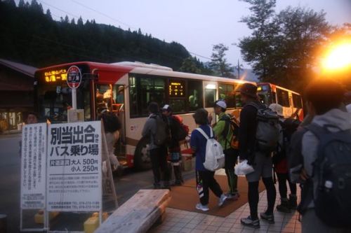
The alarm rang at 4am and we quickly sprang to work, cooking up a bowl of pasta and fresh coffee while breaking down camp in the dark. By the time we reached the bus stop at 4:45am, the queue snaked around the corner and we were denied entry to the 5am bus. Luckily there was another bus that left just 10 minutes later and we piled in for the 20-minute journey to the trailhead. Bettodeai was just as I had remembered it, though with tenfold the crowds. There’s something very unfortunate about hiking during the summer holiday peak, and that is having to share the trail with several hundred other climbers. The parking lot at Ichinose can accommodate 750 vehicles, so an attendance of over 1000 people is not unheard of in this season.

As we prepared our gear, I noticed that every single hiker seemed to be crossing the suspension bridge which leads to the Saboshindo route. This trail was closed during my first visit to the mountain, so I was very tempted to explore this route. However, it seemed best to avoid the throngs of people and use this route on the descent, so instead of crossing the bridge, we turned left and entered the Kankoshindo trail. This is the same trail that I took during my first ascent, but it honestly did not look familiar at all. The first part of the path climbed through a healthy broadleaf forest that sat still in the early morning glow. Fumito set off on a snail’s pace from the start, and I was really starting to wonder if we would even make it above the treeline before dark, but he soon found his rhythm and we walked in unison towards the ridge line. We spent most of the first hour in complete solitude, once being passed by a trail-running duo who seemed more intent on getting exercise than on enjoying the scenery.

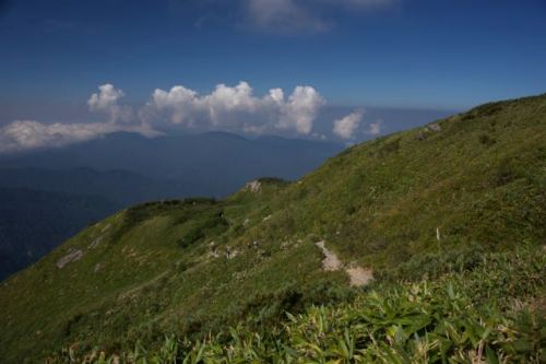
The map said to allow 1 hour and 40 minutes to reach the ridge, but we did it in just under 60 minutes. So much for Fumito’s slow pace. Even with our snail’s advance we were still passing groups along the way. The ridge marks the point where the Kanko route merges with the Zenjodo route, the traditional path up the mountain. In ancient times, these so-called “paths of meditation” converged from provinces surrounding the sacred peak. As we turned right and followed the worn stone steps along the undulating ridge, I thought of the 8th century Buddhist monk Taicho, who declared the volcano a holy site. Obviously he was drawn to the unparalleled beauty of the place – the wildflowers covering the slopes like a warm, soft blanket, the lingering snowfields which loiter around in the hot summer months, waiting for mother nature to reapply their coats of frozen paint. His devotion to the mountains spawned an entire religious sect, and this route we were now following led devotees from Echizen province to the sacred highlands above both the trees and clouds.

We settled into a steady rhythm, pausing at a large overhanging boulder that stretched all the way across the trail. We ducked under the protruding slab and sat, absorbing the fresh rays of sunlight that by now had made their way over the summit plateau directly in front of us. The warmth of the sun also brought the cloud, which threatened to swallow us and transform the mountain into that all-too-familiar world of fuzzy mist. We picked up the pace, reaching the emergency hut at Tonogaike just as my bowels released their pent-up rage. If not for the clean toilet at the recently reconstructed hut I would have surely made quite a mess on the trail.

The hut was in shambles during my last visit, but the sparkling new shelter would make for a fantastic place to overnight if not for the lack of fresh water. We were now above 2000 meters in height, and had a rather daunting ascent of 700 more vertical meters until reaching the summit. We were truly in a race against the clouds, and one in which we would likely not win.

Continuing unabated, we soon reached the junction of the Sabo shindo route, where the crowds increased a hundredfold. All of those hikers crossing the bridge at the start of the hike had now caught up to us, and we followed the freight train of sleep-deprived zombies up above the tree line. The path flattened out in a broad plateau, with wooden planks constructed to help control the massive crowds. These wooden walkways certainly were not here during my first trip, but they did make the going much smoother until they petered out at a headwall of a steep, boulder-strewn stretch of mountain. Step by step we advanced, the steep rise spitting us out right at the doorstep of Murodo village. By village I truly mean it. In addition to the sprawling visitor’s center, there was now a fully functioning post office, souvenir shop, and cafeteria that could accommodate hundreds of hungry hikers. The complex officially sleeps 750 people, but I imagine that on this particular day, they were prepared to accept double that number.
We perched ourselves on a bench on the far side of the A-frame structure, just in front of the main shrine that was currently being renovated and completely reconstructed. The pockets of the Hakusan sect truly run deep. The summit of Mt. Gozen floated in and out of the cloud like a seal bobbing in a turbulent sea. With a bit of luck we’d catch her during the ebb and not the flow.
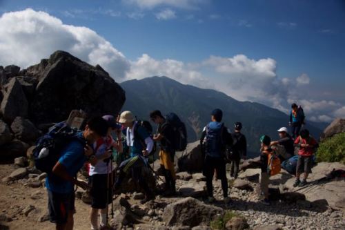
I forced four Calorie Mate bars into my parched mouth, the dry biscuits sticking to my palate as an indicator to increase the fluid intake. With 400 calories now beginning their conversion into energy, I took the lead, marching slowly but steadily up the array of stone steps that lead to the high point. I pushed all the way to the high point without a break, as the clouds had once again pushed off the plateau. At the top of Mt. Gozen, I finally caught sight of what makes Hakusan so special, for Mt. Gozen is just one of a trio of volcanic cones, dotted with pristine volcanic lakes and patches of lingering snow.

Dropping my pack among the exposed rocks, I chatted with a Vietnamese team of climbers who had come from Kanazawa for a taste of Japan’s alpine offerings. Most of the other hikers were either from the Hokuriku or Kansai regions, so I felt right at home exchanging pleasantries and mountain information in the warm sunshine. It’s not very often that you can sit at the summit of a sea-facing 2700-meter volcano in calm winds and a t-shirt and live to tell about it.

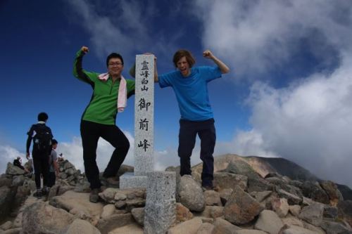
Fumito eventually reached the top, and the two of us drifted into various states of reverie. I reflected upon the stark difference of scenery that fog-free weather can make, while Fumito sucked on his cigarette like it was his last. He’s tried to give up the addiction several times, but the urge to puff had always been stronger. Regardless, he is probably the most mindful smoker in this entire country, always retreating to an unoccupied corner to satisfy his urges.
The cloud had once again swept over the plateau, so instead of dropping down to the lakes, we retreated back to Murodo in time for lunch. We feasted on udon noodles in their clear Kansai broth, a taste I have grown fond of over the years. I can’t stand the dark soups of the Kanto region. It’s as if Tokugawa Ieyasu forgot to bring along chefs from Kyoto when he moved the capital to Edo and had to improvise his broth by adding soy sauce, the worst possible ingredient available at the time. The same can be said of monjayaki, which looks just like a failed attempt at okonomiyaki, made by someone who had never eaten a real version of Osaka’s staple dish.

The noodles fueled us for the long climb back to Bettodeai. Back at the junction we veered left and onto the Sabo shindo, which switchbacked through the thick fog and down to an emergency hut that had also been recently rebuilt. Along the way, we passed several hundred other climbers, all of whom were planning on overnighting at Murodo. Among the throngs were a healthy smattering of children under the age of 10. I will only put my daughter through such hardships if the request for punishment is voluntary.

Again, we were the only people descending this route, which seems preposterous as it is a much easier drop than the Kango path that we took on the ascent. I would much rather climb an impossibly steep trail than suffer through a knee-knocking descent. Besides, isn’t a clockwise circumambulation a sign of respect to the deities?

The route, to our utter astonishment, skirts a concrete forest road in immaculate condition. The concrete follows a mountain stream until terminating at a corrugated-metal structure housing a pulley system for transporting supplies to the mountain huts. With the system resembling that of a ski gondola, it’s no wonder they just don’t open a proper ropeway for lazy tourists. Perhaps that is something in the works in time for the 2020 Olympics, in which one of the events will probably be ‘Sacred Peak Bagging’.
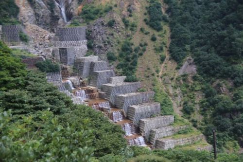
Adjacent to the gondola structure is what can only be described as a public works project gone awry, a virtual lego-block, multi-tiered network of concrete dams that rises the entire length of the valley to source of the stream itself. One strong volcanic tremor would likely send the entire structure cascading down to the trailhead far below. Despite Hakusan’s designation as both a national park and one of Japan’s 3 most sacred peaks, the environmental destruction continues unchecked.

Back in the treeline, the trail meandered through a pristine forest of towering hardwoods. In these healthy forests, I always scan the tops of the larger trees in order to catch sight of any black bears lounging in the natural hammocks above the chaos below. Pausing beneath once such tree, I raised the lens, only to find later upon closer inspection that there may have been an ursine beast lazing in the afternoon sun. You be the judge.

Click to enlarge
Fumito and I were both in pain by the time we reached the shuttle bus stop at the trailhead. My shoes have overstayed their welcome, creating hotspots on my battered feet from the worn-out treads and weakened cushioning system. Or maybe I’m just getting too old for these 1500-meter vertical ascent/descent day hikes.


