Feeds:
Posts
Comments

Archive for the ‘Hokuriku hikes’ Category

I thought my snowshoe hiking was done for the season. With temperatures already exceeding 20 degrees and the snow in the Kansai region but just a distant memory, I resign myself to a few easy hikes while waiting for the pollen to subside. In comes a text from my friends Hisao and Haru in Nagoya with an invite to climb Mt. Nōgohakusan in southern Gifu Prefecture, but the approach becomes daunting due to construction work on the forest road leading to the trailhead. To make matters worse, Haru drops out due to family commitments, so Hisao and I brainstorm ideas for a new target. I casually mention that I have never climbed Mt Dainichi-ga-take in northern Gifu and he enthusiastically jumps into action.

Right on cue, a cold pressure system moves in over the Sea of Japan, depositing fresh powder on our peak in the days leading up to our scheduled ascent. I board a nearly deserted Shinkansen train to Nagoya, ground zero for the coronavirus infection slowly gaining ground here in Japan. Donning a mask and cautious of what I touch, I make it to Hisao’s local station and we head off to a discount shop to purchase food for the hike. We hit the hay early, as the alarm is set for 4:45am. We are on the road by 5am under clear skies tinted yellow by the pollen and aeolian dust wafting through the air. Dense fog takes over after that, guiding us over a mountain pass and down into a broad valley in northern Gujō city where we break out of the clouds and are greeted with a sight to behold –  the towering white face of Dainichi staring us straight in the eye.

Hisao guides his Honda to the trailhead shortly before 7am under a cloudless sky. Half a dozen other cars sit in the narrow snow-covered parking lot as we sort through gear in eager anticipation of our climb. We’ve chosen the summer route, a path that Hisao has climbed once before. When heading to the mountains in winter, it is best to go to a place that at least one member of your party is familiar with. He assures me that it’s a straightforward route, but as we stare up at the summit plateau, the distance looks formidable. Can we really make it up there in just 3 hours?

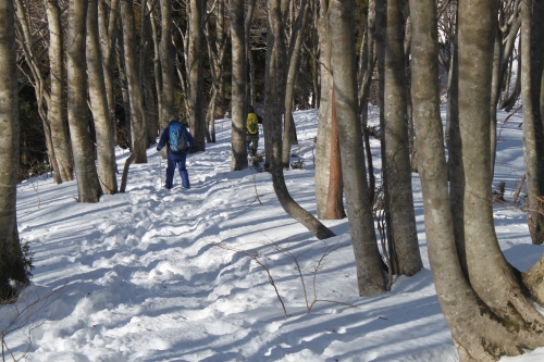
The snow is patchy at the start, but I tempt fate by strapping on my snowshoes in the parking lot, surmising that it will be easier here where the snow is just centimeters deep. A narrow gully awaits us as we place our first footfalls into the soft snow. Hisao has opted to keep his wakan strapped to his pack, a wise decision as we soon reach a steep climb dominated by tree roots sticking out from under a thin covering of snow. It is tricky work in snowshoes, but I maintain a careful placement of footsteps until the snow becomes deeper with each successive gain in elevation. A few steep sections later and we pop out on the main ridge glistening with fresh powder snow – not something we expect to find on the second day of spring.

There is a clear trace to follow, but such footsteps were not designed with snowshoes in mind, so I spend most of the time forging my own path directly adjacent to the footprints. I sink down a foot or so with each step, as the wet snow buries my boots, making each advancing step feel as if I’m carrying a barbell strapped to both feet. Hisao is amused by my struggles, for he makes good progress by following precisely the footprints made by the climbing parties ahead of us, but I keep the snowshoes strapped to my feet, for carrying them on my rucksack would just add extra weight to my upper body.

Luckily the snow condition improves as we reach Ippuku-daira, a level plateau located at around 1300 meters of elevation which marks the halfway point in our ascent. We pause briefly, shedding layers as I refill my water bottle and stuff morsels of food into my dry mouth. Hisao is completely covered in sweat, and our idyllic break spot would be perfect if not for the cacophony of blaring loudspeaker J-Pop piercing through the air from Takasu Snow Park across the valley. We’ve purposely chosen this route to avoid the ski resort, but we can’t escape its grasp entirely.

Into the lead my trusty guide Hisao walks, flowing seamlessly through the deep snow while I continue to struggle. My hard work is paying off, however, as the impressive figure of Hakusan floats high above to my right, completely caked in wintry white. It’s hard to keep my eyes off of her, entralled as I am by her sheer beauty. Hisao maintains his breakneck pace, keeping about a quarter of a kilometer ahead of me on the rambling ridge line. The snow condition finally improve at 1500 meters in elevation, turning into dry crystalline powder, the trail being sandwiched between a large cornice on my left and a windswept ice crust to my right. I make amazing progress on the icy crust as my snowshoes glide smoothly over the surface while Hisao postholes with each advancing step. The howling wind has covered up the trace of the hikers in front of us and I soon overtake my partner for the final climb to the summit. I look behind me and watch Hisao struggle up the last few meters of deep powder while I push on with ease.

As we crest the summit plateau, the full force of the winds pushing in from the nearby sea hit us head on, nearly knocking us off our feet. A handful of backcountry skiers brace themselves against the gale, which fortunately soon subsides. The skiers have come from the neighboring ski resort in search of untracked powder, but I am glad we chose the long way up. It feels much more rewarding to climb a mountain from its base than the cheat by taking the gondola most of the way up.

Hisao and I take in the views and sunshine while eating our well-deserved snack of ichigo daifuku, a savory strawberry smothered with bean paste and wrapped in a soft blanket of rice cake. Hisao swears that wagashi make the best hiking treats, and over the years I’ve seen him eating not only mochi and dango, but bars of calorie-packed yōkan as well. Perhaps there is something to his fueling approach after all. I usually just go for a Calorie Mate and a rice ball and some chocolate, but I’m willing to take a more traditional approach for my next mountain meal.

With the winds picking up and temperatures starting to drop, we run off the summit plateau, kicking balls of snow far ahead of us while blazing our own path down the main ridge that we had climbed earlier. Hisao, now donning his wakan, keeps pace in the steeper sections, but as the path flattens out he needs to stick to the main trail as he sinks too deeply in the deep powder. I make my own path through untracked sections of snow and we return to Ippuku-daira in just half the time it took us to ascend. We shed layers and rehydrate before continuing on our march back to the car. We play an entertaining game of who can last the longest before taking off their climbing equipment, and once we drop off the ridge down the spur the snow cover becomes sparse and the mud takes over. We call it a draw and sit on a toppled tree trunk to take off the snowshoes, which by now have accumulated quite a thick layer of wet snow. I strap them on the outside of my rucksack as we walk the remaining snow-free distance back to the car, arriving shortly after noon.

Such epic climbs can only be topped by a soak in a local hot spring, so Hisao finds a beauty of a place on his car navigation system while we settle in for a refreshing bath and filling tonkatsu lunch. The dining room overlooks a narrow valley and we both wonder if this place will survive the impending viral and economic storm about to be unleashed in Japan.


Read Full Post »

The first step in climbing the highest mountain in each of Japan’s 47 Prefectures involves an online search for a list of the peaks. To the uninformed, one may surmise that there must surely be 47 mountains on the list, but due to the fact that a handful of highest mountains straddle prefectural borders, the target list is reduced to 43 unique summits. 24 of those peaks also double as Hyakumeizan, so those who have finished the 100 just need to climb an additional 22 mountains to complete the list. Unfortunately, some of these mountains defy the limits of what is considered an ‘accessible’ mountain.

San-no-mine is one of those mountains. Situated on the border of Fukui and Ishikawa Prefectures, the peak is part of the Ryōhaku mountain range and doubles as the southernmost 2000-meter mountain in Japan. It also lies along the Hakusan ridge line, just an additional two hours further south of Bessan. This is the exact same ridge I traversed during my first trip to the sacred summit and indeed, during that fateful traverse I overnighted at San-no-mine emergency hut. Little did I know at that time, but Fukui’s highest peak is situated directly behind the hut on a knob of hill named Echizen-Sannomine. But our story becomes a bit more complicated, as this tuft of bamboo grass is actually not considered to be a peak but just a chiten (地点) or highest point in the prefecture. The highest mountain honor goes to neighboring Ni-no-mine, a further hour from the emergency hut and my target for a long-overdue return to the Kamiuchinami district of Ono city deep in the heart of Fukui.

Joining me on the weekend festivities in mid-September is no other than my trusty companion Paul M.. Neck-deep in writing and editing his PHD dissertation, Paul graciously agrees to not only accompany me on the long journey, but to also drive the entire way, eliminating the need for a expensive taxi or unreliable journey by thumb. He picks me up in Kobe city as we head north along the newly-completed Maizuru-Wakasa expressway for the 4-hour journey to the trailhead. Long drives on Japan’s frantic road system are truly taxing affairs, and we break up the drive by stopping off to visit Eiheiji Temple just outside of Fukui city. Home to the Soto sect of Zen Buddhism, the sprawling temple complex is truly one of Japan’s most interesting places. But you wouldn’t know that if you just walked along the towering cryptomeria trees flanking the long promenade to the main entrance.

The grounds themselves are pleasant enough but the real treasure is what lies beyond the walled entrance of the compound. To be honest, we are none-too-thrilled about forking over 500 yen for yet another temple in Japan. So many times you pay the fee and enter a temple that is nearly off-limits to visitors sans a random garden or common tatami worship space. And most of the more famous temples of Japan that are worth seeing are so overrun with tourists that they take on a Disneyland atmosphere. Not so at Eiheiji. Paul and I enter the reinforced concrete building and step into a lecture room led by a Soto monk clad in black. He stands in front of an enormous wall painting of the temple complex, pointing out each area of the grounds along with a set of stringent rules about acceptable behavior. I scan the room and realize that there aren’t any other foreign tourists among the 30 or so Japanese visitors to the temple grounds. Indeed, during the 3 hours that we spend exploring the temple and surroundings, it becomes clear that this temple has yet to be discovered by the rowdy Asian tourists that have completely overtaken most of the other popular sightseeing spots in Japan. It reminds me of a time before the Chinese and Korean tourism boom, when you could actually enjoy a place surrounded by well-mannered Japanese tourists who respect the local customs.

Eiheiji is truly one of those ‘must see for yourself’ kind of places, and I will definitely return for a visit if the opportunity presents itself. On the way back to the car, we stop off for an iced coffee float before the drive to our inn at Kadohara. The sleepy village brings back memories of my ascent of Mt Arashima, and the idyllic train station near the trailhead. After checking in, we head down to the station, where I find that the run-down toilet has been completely torn down and replaced with a much larger restroom in a park on the other side of the train tracks. Resisting the temptation for a revisit to Arashima, we retreat back to our room for an early night and an even earlier start. Breakfast is served at 6am as we fuel up for the impending climb.

Paul M. manuvers his vehicle up the hairpin turns to the trailhead under a brilliant sky of crystal blue. San-no-mine towers over the road like a Spinosaurus that once roamed these very forests of Fukui. We brush off the temptation to visit the Dinosaur Museum – instead we gaze our eyes upwards to the gold-tinted alpine scenery. Stowing unnecessary gear in the car, we enter a trail that immediately loses altitude to reach a forest road that leads up towards Karikomi Ike, one of Fukui’s most renowned places for autumn foliage. The September greenery has kept the crowds at bay for now, so we march in unison up the deserted road before reaching the trailhead through a lush forest of beech and oak.

The path immediately gains altitude towards a steep spur. It takes a few minutes to settle into a rhythm and to shake off the morning fatigue, but once our body adjusts to the incline we make good time, reaching the crest of the spur in about 90 minutes. We rest briefly on the gnarled roots of a cypress tree while replenishing minerals lost to sweat. A cool northerly breeze kisses the spur, sending us into action to stave off the chill.

The wind lifts the fog upwards from the secluded valley, lapping the trail in a mimic of an excited canine that blots out the view. As an upside to the reduced visibility is the lack of a visual gauge to our progress – there’s nothing more disheartening to be staring a huge climb straight in the face and being able to see, inch by inch, how far you truly have to go. We lower our heads and advance, footfall by heavy footfall, into the unknown.

Well, not entirely into the unknown, as I had actually been down this trail once before during my first traverse of Hakusan, but it was so long ago and in such decrepit conditions that the scenery feels completely new. It’s amazing how your mind can play tricks on you, a spur that seemed so easy just a decade ago can prove so formidable through the passage of time. That’s what age will do to you.

A fortress of rock emerges from the mist, the path hugging the northern edge of the precipice along a maze of slippery boulders. Using hands to help propel us forward, we reach the top of the aptly-penned Ken-ga-iwa to glance a patch of blue sky at the top of a crest directly above. Paul and I look at each other in amazement, wondering if we could, perhaps pierce through this cloud veil and rise above its misty sea. The fog and sun are embraced in a fierce battle for supremacy, the northernly winds continue to throw sheets of mist towards the bright rays of sun. Glimpses of jaw-dropping views are erased faster than the shaking of an Etch A Sketch as the two intrepid trekkers continue to soar above it all.

Just below breaching the 2000 meter mark, the warming rays of the sun are too much for old-man cloud to handle, and smiles stream across our faces at the incredible early-autumn scenery spread out before us. We pause briefly upon reaching the emergency hut, the very same one I used as shelter many moons ago. Knowing these views could be taken away at any moment, we pick up the pace and reach the summit of San-no-mine just in time to take in the million-yen views. Our work is far from done, however, as we still have two more mountains to cover.

We retrace our steps back to the hut and settle into a quick lunch before the unmarked climb to Echizen-Sannomine. A faint trail leads into head-high bamboo grass behind the hut. I take the lead, pushed on by an unseen force to the top of the hill. We meet two other hikers who have just begun their descent. They inform us that the summit is at the top of the next crest, which we reach a short time later. Here we find a small summit signpost. It’s a good thing that I did my research before heading out, because without prior knowledge there would be no way to know that Fukui’s highest point is along this completely unmarked swath of land.

With the highest point now off the list, we return to the hut and start our descent towards Ni-no-mine, the official highest peak of the prefecture. The trail loses about a hundred meters of vertical elevation before reaching a saddle and short climb to the summit. A signpost just off the trail reads Ni-no-mine but my GPS informs me that the actual top of the mountain lies beyond in an incredibly dense maze of two-meter-tall bamboo grass. Paul decides that this is best tackled as a solo mission and enjoys a well-earned break as I dive straight into the labyrinth. This brings back memories of Mt Mikuni, a monster of a bushy ridge that lies in, you guessed it, Fukui Prefecture.

Climbing hand over fist, slashed by razor-sharp leaves, and stumbling over toppled trees hidden beneath the mess, I reach what I surmise to be the summit. Or at least it’s what I’m calling the summit. There is no higher place to go, and while I am unable to find a triangulation point or summit signpost, I claim victory on my right to claim Fukui’s highest mountain successfully climbed. My guess is that the majority of 47 Pref-baggers consider Echizen-Sannomine suffice for their criteria. I find no fault in that.

By the time we retrace our steps back to the emergency hut, I am a battered mess. I engulf an caffeine-infused evergy gel as we start our descent back to the valley. The fog has now returned, thicker than ever and depositing a fine mist all over the route. I settle in on a steady pace, not wanting to stop for fear of bottoming out on my energy reserves. The tricky drop before Ken-ga-mine puts to rest those fears, as my feet slip out from under me and I land straight on my bottom on a wet rock. That episode sends a shot of adrenaline back into my system that sustains me for the rest of the hike.

The parking lot is once again reached just before 3pm while we psyche ourselves up for the long drive back to Kobe. Paul declares that a hot spring is in order, and nearby Hato-ga-yu  does the trick, easing the pain from our overworked muscles. We made good time back to Kobe, as we manage to avoid most of the traffic jams by heading back through Maizuru through pockets of rain cloud. With Fukui’s highest mountain now off the list, just one mountain stands between me and my quest to climb the highest peak in every prefecture. With the winter snows soon to envelope the higher peaks, the race is on to claim victory on Niigata before my climbing window closes.

Read Full Post »

My first trip to Hakusan was a total washout, and ever since that dreadful ascent back in 2004 I was looking for a chance to appreciate the mountain without having to bag a peak on the list. That’s the beauty of a re-climb, as there’s no pressure to summit the mountain at all. With that in mind I once again teamed up with Fumito, who was still recovering from a rock climbing trip to nearby Gozaisho. He picked me up at Nagoya station shortly before noon and then pointed the car north, through Gifu Prefecture and then onto route 158, where we passed by the trailhead to Mt. Arashima. It was very tempting to pull the car off to the derelict ski resort for an afternoon ascent, but we had our eyes set on the big hike tomorrow.

IMG_7993

We arrived at Ichinose just after 4pm and set up camp near the river in the tranquil campground. Due to the immense popularity of Hakusan, private cars are no longer allowed to Bettodai during the weekend and Obon peak, so we simply had to wait for the first shuttle bus at 5am the following morning. We killed time in the rustic hot spring bath across from the bus stop, soaking up the minerals that we hoped would provide some extra energy for the impending climb.

IMG_8038

The alarm rang at 4am and we quickly sprang to work, cooking up a bowl of pasta and fresh coffee while breaking down camp in the dark. By the time we reached the bus stop at 4:45am, the queue snaked around the corner and we were denied entry to the 5am bus. Luckily there was another bus that left just 10 minutes later and we piled in for the 20-minute journey to the trailhead. Bettodeai was just as I had remembered it, though with tenfold the crowds. There’s something very unfortunate about hiking during the summer holiday peak, and that is having to share the trail with several hundred other climbers. The parking lot at Ichinose can accommodate 750 vehicles, so an attendance of over 1000 people is not unheard of in this season.

IMG_8050

As we prepared our gear, I noticed that every single hiker seemed to be crossing the suspension bridge which leads to the  Saboshindo route. This trail was closed during my first visit to the mountain, so I was very tempted to explore this route. However, it seemed best to avoid the throngs of people and use this route on the descent, so instead of crossing the bridge, we turned left and entered the Kankoshindo trail. This is the same trail that I took during my first ascent, but it honestly did not look familiar at all. The first part of the path climbed through a healthy broadleaf forest that sat still in the early morning glow. Fumito set off on a snail’s pace from the start, and I was really starting to wonder if we would even make it above the treeline before dark, but he soon found his rhythm and we walked in unison towards the ridge line. We spent most of the first hour in complete solitude, once being passed by a trail-running duo who seemed more intent on getting exercise than on enjoying the scenery.

IMG_8092

The map said to allow 1 hour and 40 minutes to reach the ridge, but we did it in just under 60 minutes. So much for Fumito’s slow pace. Even with our snail’s advance we were still passing groups along the way. The ridge marks the point where the Kanko route merges with the Zenjodo route, the traditional path up the mountain. In ancient times, these so-called “paths of meditation” converged from provinces surrounding the sacred peak. As we turned right and followed the worn stone steps along the undulating ridge, I thought of the 8th century Buddhist monk Taicho, who declared the volcano a holy site. Obviously he was drawn to the unparalleled beauty of the place – the wildflowers covering the slopes like a warm, soft blanket, the lingering snowfields which loiter around in the hot summer months, waiting for mother nature to reapply their coats of frozen paint. His devotion to the mountains spawned an entire religious sect, and this route we were now following led devotees from Echizen province to the sacred highlands above both the trees and clouds.

IMG_8099

We settled into a steady rhythm, pausing at a large overhanging boulder that stretched all the way across the trail. We ducked under the protruding slab and sat, absorbing the fresh rays of sunlight that by now had made their way over the summit plateau directly in front of us. The warmth of the sun also brought the cloud, which threatened to swallow us and transform the mountain into that all-too-familiar world of fuzzy mist. We picked up the pace, reaching the emergency hut at Tonogaike just as my bowels released their pent-up rage. If not for the clean toilet at the recently reconstructed hut I would have surely made quite a mess on the trail.

IMG_8112

The hut was in shambles during my last visit, but the sparkling new shelter would make for a fantastic place to overnight if not for the lack of fresh water. We were now above 2000 meters in height, and had a rather daunting ascent of 700 more vertical meters until reaching the summit. We were truly in a race against the clouds, and one in which we would likely not win.

IMG_8176

Continuing unabated, we soon reached the junction of the Sabo shindo route, where the crowds increased a hundredfold. All of those hikers crossing the bridge at the start of the hike had now caught up to us, and we followed the freight train of sleep-deprived zombies up above the tree line. The path flattened out in a broad plateau, with wooden planks constructed to help control the massive crowds. These wooden walkways certainly were not here during my first trip, but they did make the going much smoother until they petered out at a headwall of a steep, boulder-strewn stretch of mountain. Step by step we advanced, the steep rise spitting us out right at the doorstep of Murodo village. By village I truly mean it. In addition to the sprawling visitor’s center, there was now a fully functioning post office, souvenir shop, and cafeteria that could accommodate hundreds of hungry hikers. The complex officially sleeps 750 people, but I imagine that on this particular day, they were prepared to accept double that number.

IMG_8195

We perched ourselves on a bench on the far side of the A-frame structure, just in front of the main shrine that was currently being renovated and completely reconstructed. The pockets of the Hakusan sect truly run deep. The summit of Mt. Gozen floated in and out of the cloud like a seal bobbing in a turbulent sea. With a bit of luck we’d catch her during the ebb and not the flow.

IMG_8191

I forced four Calorie Mate bars into my parched mouth, the dry biscuits sticking to my palate as an indicator to increase the fluid intake. With 400 calories now beginning their conversion into energy, I took the lead, marching slowly but steadily up the array of stone steps that lead to the high point. I pushed all the way to the high point without a break, as the clouds had once again pushed off the plateau. At the top of Mt. Gozen, I finally caught sight of what makes Hakusan so special, for Mt. Gozen is just one of a trio of volcanic cones, dotted with pristine volcanic lakes and patches of lingering snow.

IMG_8213

Dropping my pack among the exposed rocks, I chatted with a Vietnamese team of climbers who had come from Kanazawa for a taste of Japan’s alpine offerings. Most of the other hikers were either from the Hokuriku or Kansai regions, so I felt right at home exchanging pleasantries and mountain information in the warm sunshine. It’s not very often that you can sit at the summit of a sea-facing 2700-meter volcano in calm winds and a t-shirt and live to tell about it.

IMG_8224

Fumito eventually reached the top, and the two of us drifted into various states of reverie. I reflected upon the stark difference of scenery that fog-free weather can make, while Fumito sucked on his cigarette like it was his last. He’s tried to give up the addiction several times, but the urge to puff had always been stronger. Regardless, he is probably the most mindful smoker in this entire country, always retreating to an unoccupied corner to satisfy his urges.

IMG_8281

The cloud had once again swept over the plateau, so instead of dropping down to the lakes, we retreated back to Murodo in time for lunch. We feasted on udon noodles in their clear Kansai broth, a taste I have grown fond of over the years. I can’t stand the dark soups of the Kanto region. It’s as if Tokugawa Ieyasu forgot to bring along chefs from Kyoto when he moved the capital to Edo and had to improvise his broth by adding soy sauce, the worst possible ingredient available at the time. The same can be said of monjayaki, which looks just like a failed attempt at okonomiyaki, made by someone who had never eaten a real version of Osaka’s staple dish.

IMG_8251

The noodles fueled us for the long climb back to Bettodeai. Back at the junction we veered left and onto the Sabo shindo, which switchbacked through the thick fog and down to an emergency hut that had also been recently rebuilt. Along the way, we passed several hundred other climbers, all of whom were planning on overnighting at Murodo. Among the throngs were a healthy smattering of children under the age of 10. I will only put my daughter through such hardships if the request for punishment is voluntary.

IMG_8124

Again, we were the only people descending this route, which seems preposterous as it is a much easier drop than the Kango path that we took on the ascent. I would much rather climb an impossibly steep trail than suffer through a knee-knocking descent. Besides, isn’t a clockwise circumambulation a sign of respect to the deities?

IMG_8299

The route, to our utter astonishment, skirts a concrete forest road in immaculate condition. The concrete follows a mountain stream until terminating at a corrugated-metal structure housing a pulley system for transporting supplies to the mountain huts. With the system resembling that of a ski gondola, it’s no wonder they just don’t open a proper ropeway for lazy tourists. Perhaps that is something in the works in time for the 2020 Olympics, in which one of the events will probably be ‘Sacred Peak Bagging’.

IMG_8376

Adjacent to the gondola structure is what can only be described as a public works project gone awry, a virtual lego-block, multi-tiered network of concrete dams that rises the entire length of the valley to source of the stream itself. One strong volcanic tremor would likely send the entire structure cascading down to the trailhead far below. Despite Hakusan’s designation as both a national park and one of Japan’s 3 most sacred peaks, the environmental destruction continues unchecked.

IMG_8148

Back in the treeline, the trail meandered through a pristine forest of towering hardwoods. In these healthy forests, I always scan the tops of the larger trees in order to catch sight of any black bears lounging in the natural hammocks above the chaos below. Pausing beneath once such tree, I raised the lens, only to find later upon closer inspection that there may have been an ursine beast lazing in the afternoon sun. You be the judge.

Click to enlarge

Click to enlarge

Fumito and I were both in pain by the time we reached the shuttle bus stop at the trailhead. My shoes have overstayed their welcome, creating hotspots on my battered feet from the worn-out treads and weakened cushioning system. Or maybe I’m just getting too old for these 1500-meter vertical ascent/descent day hikes.

Read Full Post »

The mountains facing the Sea of Japan rarely get a break. The Siberian winds whip up moisture on their journey from Russia, depositing immense loads of powder snow that lingers until the arrival of the summer rain front, which keeps the Hokuriku region locked tight in a slippery vice grip. When it’s not raining or snowing, the peaks seek shelter behind veils of low-lying cumulus, withholding the vistas to all but only the most dedicated few. I had studied the meteorological charts for weeks, looking for a rare clear-weather window to explore Tsuruga’s most hallowed peak: the beech-crowned heights of Mt. Nosaka, ‘the wild hill’.

nosaka1

My chance came on a Tuesday. Not the best of timing, but when that window opens, you have no other choice but to tempt fate and jump out. I boarded the Limited-Express Thunderbird train at the luxurious hour of 9am for the 90-minute sprint to Tsuruga, where the Obama line regurgitated me on the steps of Awano station. The cloudless sky burned a glorious shade of blue as I marched up the paved road to the A-frame bungalows marking the entrance to the forested path. Puddles of black ice waited to catch the unwary driver or, in my case, the lone hiker off-guard. Several times I slipped on the horizontal verglas, saving myself from a likely bruise with some quick handwork with the trekking poles.

nosaka2

I soon hit snow, but held off on the crampons until there was unobstructed ground cover, and slowly marched along the easy-to-follow path. Judging by the well-worn prints, several climbing parties were already on their way to the top. The route crossed a stream several times before scaling a small metal staircase which marked the true start of the climb. Here I latched the 6-pointers firmly to my soles and continued my vertical progress towards the ridge. Through gaps in the bare tree limbs I could begin to see the contours of Tsuruga city expand directly below: it resembles most port towns in Japan except for the unusual concentration of nuclear power plants hidden in the coves to the west.

nosaka4

After an hour of brisk ascending I topped out near the ridge and got my first unobstructed views of Hakusan’s curvy mastiff. It appeared as if the baker had gone overboard on the frosting for this gargantuan birthday cake to the deities. The peak was well on the way to an average snow year, and if the current rate of precipitation continues, it could very well set a new record for snow depth. Early January, however, is much too early to make such predictions. Besides, I had a mountain ahead of me to climb.

nosaka5

At my first rest point, I met a lone hiker on his way down from the summit. “This is the best January weather in over 5 years,” remarked the tan-skinned elderly gent sporting a thick white beard. Despite the icy conditions, he was wearing only a pair of rubber rain boots and opted for the thickness of the untouched powder rather than the slick grooves of the main trail. He told me it would take about half an hour to reach the summit from here, even though the maps suggested a conservative time of 50 minutes.

nosaka3

From here I reached the ridge, clambering over a series of false summits through a tunnel of elderly beech trees accustom to the stinging gales of winter. I soon spied the roof of the summit emergency hut protruding from the top of the next rise, and sure enough, about thirty minutes since leaving my haunches, I topped out to some of the best panoramic views I’ve seen in Kansai. The mountains of Gifu pierced the sky sharply, while a long strand of cloud hid the Kita Alps from view. Mt. Ibuki and the rest of the Lake Biwa Orchestra belted out a silent tune, while further to the west the peaks of northern Kyoto Prefecture begged for attention. That was still one area I had yet to explore, as access made a day-approach without an automobile all but impossible. I chatted with another group seeking shelter from the winds in the emergency hut. They were all from Tsuruga, and were quite surprised that I had come all the way from Osaka just to climb their local mountain. I explained that Nosaka was indeed one of the Kansai Hyakumeizan. They laughed that it was included on the list: “this is Hokuriku, not Kansai.” They had a point.

nosaka6

Deciding to play it safe, I headed down preciously the same way I had climbed, forgoing any shortcuts off the mountain. I’ve taken enough risks on snow-capped peaks trying to shave a few minutes off a hike. The way down was actually more challenging than the climb, as the crampons threatened to send my ankles into contorted positions that the tendons were not designed to accommodate. Once I reached the river again, I took off the irons for the walk back to the pavement. One of the hikers I had met in the hut offered me a ride to Tsuruga station, where I was just able to make the train back to Osaka.

nosaka7

I had now completed 71 of the Kansai 100, which left me with a new challenge: reach magic number 75 before the start of the rainy season. Time to start more intensive planning.

Read Full Post »

Every summer, from roughly mid-June to the middle of July, a stationary front settles in over the western half of Japan, bringing long periods of uninterrupted rainfall. Known in Japanese as the tsuyu (plum rains), this torrential rain can often bring landslides, flooding, and treacherous hiking conditions. There’s a public holiday called Marine Day that is conveniently placed at the end of this wet spell. Mother Nature, however, doesn’t necessarily decide to move her weather front out of the archipelago on exactly the same day every year, which can leave hikers in a bit of a predicament. So started my quest to climb the highest mountain west of the Japan Alps.

The overnight bus pulled into Kanazawa station, where I searched out for the bus stop to Bettodai , the starting point for the long climb up Hakusan, whose Chinese characters translate as White Mountain. Known for its deep drifts in the winter, the peak is a straightforward climb up a steep valley filled with wonderful flowers and lingering patches of snow. As the bus raced up the valley towards the trailhead, the rivers flowed in a torrent of chocolate brown, the dams overflowing with debris amidst a thundering roar of whitewater. The rain continued to fall steadily as a looked around at the half a dozen other passengers. After disembarking, I headed to the small shelter of the bus stop, put on the rain gear, and marched steadily towards the treeline. My plan was simple: hike up to the high point and head south along the ridge, pitching camp at the flatlands of Nanryu.

A third of the way up, I ran into my first group of nylon-clad hikers. “Oh your pack is way too loose”, quipped the fearless middle-aged leader. Grabbing the load lifters, he pulled on them as tightly as they would go, unaware that I was intentionally wearing them loose to keep the weight off my shoulders and onto my hips. I let out a gentle squeal, grimaced as inconspicuously as I could, dropping the pack off my torso the minute the group started on the trail ahead of me. I intentionally gave them an extra long head start lest I bumped into them again and Mr. know-it-all tried to offer more backpacking tips. The higher up the valley I headed, the thicker the cloud cover. Soon I disappeared from view all-together, stumbling across a decrepit-looking emergency shelter in the flower fields before Murodo. Resting briefly, I munched on some chocolate to help restore the stamina. I had hardly slept on the overnight bus, and the constant frigid rain meant any breaks were life-threatening. After what seemed like an eternity, the trail I was on ran head-long into the large hut and temple complex just below the high point of Gozen-hou. The temperature was hovering around freezing, with a strong wind blowing rain every direction imaginable. I couldn’t fathom having to camp in this dreadful weather, so I did what any sensible mountaineer would have done and checked into the hut. Since I wasn’t having meals, the hut staff directed me to an adjacent building, where I joined a dozen or so other brave souls who were cooped up for the night. After warming myself with a hot cup of tea, I ventured back out into the murk to reach the summit, officially checking mountain #18 off the list.

The next day the weather fared no better, but in my stubbornness I kept with the program and headed up and over Mt. Bessan anyway. The trail dropped for an hour or so to Nanryu, where the hut and campsite lay exposed to the wicked wind and fiery rains. I had to keep moving to stay warm, so I sped past the hut and up the ridge towards the exposed rocks of my target peak’s bare figure. I only encountered one other soul, who, crouched behind a rock just shy of the top, warned me of the dangers:  “strong wind, cold”. I was in my red nylon super rainsuit, but knew he must have been suffering in his plaid shirt and wrinkled cotton vest. I continued along the ridge as if in a trance, reaching the emergency hut on the other side of San-no-mine just before 3pm. Dropping my gear, I sat on the wooden sleeping platform, took a deep breath, and declared that I would walk no further that day. I had a dry and warm place to sleep, and my only other option was to descend to the valley below and camp in what must surely be a swampland. My only predicament was where to find water. Grabbing my water filter, I went around the back of the hut and started trying to pump rain water from some nearby puddles. I had only managed to get about 200ml of liquid before giving up in frustration. “There has to be a snowfield around here,” I exclaimed. With a new sense of urgency, I went into hunting mode, scanning the fog-covered horizon in search of a sign of snow. Unfortunately, snow and fog happen to be nearly the same hue of white, so my only option was to find with my feet what I couldn’t sense with my eyes. Climbing the crest of a hill behind the hut, I shot down the other side, slipping on a patch of slushy white gold. Snow! And remarkably close to the hut as well. I filled up a pot full of frozen crystals and went to work, melting enough snow for not only tonight’s dinner, but enough to see me off the mountain the following day.

No other souls presented themselves at the hut the rest of the day. I cooked, cleaned and organized, collapsing in my sleeping bag shortly after the darkness enveloped the mountain. Listening to the sounds of the steady rain ricocheting off the metal roof, I silently praised myself for my decision to overnight here. The rain continued on well into the next morning, as I kept thinking of excuses to delay my departure. Eventually the thoughts of a warm bath proved too great to refuse, and I slipped out of my warm home and down the steep spur into the forest. I stumbled across several large snakes who were probably not used to have their stomping grounds invaded. The trail looked as if it had received only a handful of visitors this year alone, but thankfully there were enough signposts to make things navigable. Once at the campground, I peered at the bus timetable only to discover that it had been discontinued! I was in the middle of nowhere and a long way from anything, but at least the rain had finally let up. No cars to hitch a ride from, and no one to ask for directions. I knew the hot spring lie at the bottom of this valley, but walking there on a sealed asphalt road in the mist was easily of the worst things I had done in my short time in Japan. It took nearly 2 hours before I reached the bathhouse, which fortunately was open. I had a relaxing bath while trying to sort out the bus, which didn’t seem to be running today. In fact, there didn’t seem to be much traffic at all. The bath owner suggested that I should try to hitch out of there, so after my cleansing I walked out to the main road and stuck out my thumb. A prefectural utility truck pulled over and ushered me in. “There’s no train, so you’ll have to take a bus”, advised the government workers. They were out clearing debris from the road and warned me of the mudslides that had hit other parts of the prefecture. At Echigo-Ono station, I boarded an empty bus bound for Fukui station, but still couldn’t understand why I couldn’t take the train.

The bus scooted along abandoned roads, following a heavily swollen river that had emptied its contents into the neighboring villages. The locals were sweeping water and mud out of their homes and storefronts. Apparently while I was braving the elements at Murodo, the river jumped the banks and flooded not only Fukui city, but most of the houses between there and Echizen-Ono. To make matters worse, the train line lie in a twisted contortion along the banks of the river, stripped of its foundations. I now knew the reason for the lack of trains, and wondered if such a rural line with only 1 track would ever get rebuilt. I considered myself extremely lucky to have been able to make it out of there at all. If the flood waters had crested only a few days later, then I surely would have been trapped.

White Mountain gave me nothing but trouble. I’ve heard it’s a lovely peak. There are even some scenic volcanic lakes dotted around the summit, but I never got to experience the beauty of the place. Perhaps a re-visit is in order, but only during the dry season.

Read Full Post »

With my eyes set on reaching mountain #40 before the winter snows close in, I board an early morning train for Fukui, where a majestic peak lying in Kyuya Fukada’s hometown awaits. The Etsumihoku line is still under repair from the massive flooding that hit the prefecture in 2004, just as I was making my way off Hakusan. The train ran part of the way towards Echizen-Ono city before we were whisked off the train and onto a shuttle bus past the sections that still lay at the bottom of the river. Once past the washed-out area, it was back onto a different train that stopped at Kadohara station, my starting point for Mt. Arashima, which translates as “tempest island”. Hopefully the peak would not live up to its name.

Once outside of the unmanned station, nature soon called, so I found the small station toilet, which, like most rural station restrooms in Japan, was devoid of that tubular, soft white tissue used to clean up after making a deposit. I searched in haste, scooping up some fallen leaves from the side of the road before the pressure in my bowels was forcefully released. I cleaned up as best I could and staggered uncomfortably up the road to the small ski resort, which thankfully had a much better-supplied restroom. Disaster averted, I followed the trail straight up and around the lift pylons of the overgrown ski resort before ducking into the virgin beech forest.

Even though it was mid-October, I was unfortunately too early for the autumn foliage. The tips of the leaves were just beginning to change, but a few weeks from now the entire area would be ablaze with brilliant oranges and vibrant yellows. I tried not to focus on what I would be missing, instead keeping my thoughts on the ridge that rose just out of reach. Eventually I did reach the top of the rise, which was little more than a tease, since the peak actually sat on an adjacent fold of mountain. From here I’d need to drop to a saddle and face a brutal, incredibly steep climb up the spine of the beast. Wisely, I took a breather and re-fueled.

I can only imagine how treacherous and tricky this peak must be in the winter. Even in early December, the summit throws up formidable challenges. The initial climb from the saddle is a grab-what-you-can pull-up exercise through bamboo grass, exposed tree roots, and slippery mud. Beyond that, it becomes a series of false summits, which each one deceptively further than the next. Sensing the summit just over the next rise, you push yourself a little extra, knowing that a long break on top lie several meters out of reach. Deceived, you repeat the process ad nauseam, until finally collapsing in a heap of sweat beneath the modest shrine sitting squarely on the true summit. On this gorgeous autumn day, the peaks of northern Kansai rolled south on eternal folds, all the way to Lake Biwa. The Northern Alps sat behind a thick bed of cloud, just as Hakusan was revealing her shy figure to the early afternoon sun.

During my lazy break, an elderly gentleman who oozed experience from his sweaty pores came over for a chat. Placing his business card between my outreached hands, he explained that he was the unofficial caretaker of the mountain, and climbs several times a month to assess trail conditions and to remove any fallen timbers from the path. These kinds of locals can be found throughout Japan, whose unselfish endeavors ensure that Japan’s trails are some of the best-kept in the entire world. Many other countries have trail-maintenance volunteers, but none with the unyielding vigor and consistency of these unsung heroes.

Eventually I worked up the courage to bid farewell to the warm sunshine and majestic views and sunk back into the treeline, wondering if I’d make the 4pm train back to Fukui. On the descent I passed by several slower groups of climbers, and once I reached the ski resort parking lot I was able to easily negotiate a ride back to Fukui station, where I settled into a seat on an Osaka-bound train. Arashima was well-behaved on this excursion and let me off relatively easy. I was now done with every peak in western Japan and Shikoku, but still had 60 peaks to the north that eagerly awaited my arrival.

Read Full Post »

As I begin to melt snow, I notice the flame growing weaker with every passing flicker. “Oh, why didn’t I bring a full can of gas,” I scream, regretting my decision to wait until the last possible minute to pack. I’d brought one other canister, but could easily use that one just melting snow. The 3rd thorn on this unpredictable trip. Conserving as much fuel as possible, I manage to cook dinner and breakfast the next morning while melting enough snow to fill up my 2 liter platypus. Off to bed to dream about my impending ascent.

oizuru2-1

“Damn cedar pollen!” These are the words that first came to mind after a long night of sniveling and sneezing. I left everything in my tent and stuffed my platypus, energy gel, and a few snacks in my bum bag for the 3 hour climb. The other climbing party had been drinking heavily the previous evening, so I had the peak all to myself. Following a clearly defined set of footprints, I clamber over half-buried trees before climbing up to the spur. The higher I climbed, the heavier my bag seemed to become and the wetter my back became. One quick inspection revealed that my platypus bottle had leaked over a liter of water into my pack. If I got any more thorns on this trip I’d surely turn into a rose.

oizuru2-2

Low on water and drenched from the leakage, I pushed on. “Time to start eating snow,” I proclaimed, stuffing a handful of the frigid ice into my parched mouth. Upon reaching the spur, I was greeted with Hakusan’s brilliant edifice on my right, as well as a steep drop to a saddle before the final summit push of Mt. Oizuru. I slid down to the saddle, being careful to stay away from the gnarly cliff edges on my right. The final climb began: kick, step, kick, step, kick. At this rate I’d be lucky to make it up before dusk. Slowly but steadily I thought about what would happen if I gave up this far into my attempt. It was those thoughts that eventually landed me on top of the bald summit, where I collapsed and ate a late morning snack. The Kita Alps and Mt. Norikura were clearly visible on the horizon, a blanket of haze between here and there.

oizuru2-3

I retreated back the way I came, passing by my camping neighbors who’d gotten a much later start. I make it back to camp in time to cook up some noodles and melt some more snow. Luckily, I had a couple of PET bottles I could use in lieu of the torn water pouch. Refueled, I broke down camp and retreated to the steep valley far below. I’d had a hard enough time climbing up the ridiculously steep spur, but made my way down without any notable mishaps. Back at the parking lot, I spy a beautiful park across the street and quickly investigate. It looks like an amazing place to camp, with lush green grass and flowing river. “Best to set up camp after dark, just in case,” I mutter, opting for a visit to the nearby hot spring.

oizuru2-4

I woke at dawn to the sound of screeching birds outside of my tent. Unzipping my tent fly to investigate, I am shocked to be surrounded by a pack of wild monkeys, chasing each other and foraging for food in the early morning light. Monkey claws and tent fabric don’t mix, so I did my best not to attract attention to my newly-bought tent. Fortunately, the creatures were more interested in playing in the trees and concrete suspension bridge than raiding my food supplies.

oizuru2-5

I pack up my things and wait by the main road, thumb outstretched. After a half an hour of cars whizzing by, I notice two figures with abnormally large backpacks walking towards me from the other direction. They’d just come down a monstrous ascent of Hakusan, and immediately offered me a ride. Along the way, we picked up another hiker and all went back to Kanazawa together. What an adventure this Golden Week has been, and I’m only on my second day. Little did I know that my adventure were about to become a lot more perilous on the steep slopes of Mt. Kongodo. Stay tuned….

Read Full Post »

Shortly after conquering the Hyakumeizan, I was given the guidebooks for the 200 famous mountains. “Oh boy”, I sighed, “here we go again.” While I haven’t fully committed to undertaking this formidable challenge, I have accepted the mission of exploring a few that have sparked my interest. Thus, my recent foray deep into Ishikawa Prefecture, to scale a peak that Mr. Fukada himself never got the chance to summit: Mt. Oizuru.

oizuru1

Mt. Oizuru (笈ヶ岳) is quite possibly the only peak in Japan that can not be climbed year round. On the contrary, the only time the summit is approachable is when snow flanks its steep slopes, from December to early May. I set off from Osaka, making the necessary transfers until arriving at Tsurugi station on the soon-to-be-abolished Ishikawa line of the Hokuriku railroad. Walking out to route 157, I stuck my thumb out, hoping for the best.

oizuru2

A few minutes later, a Hummer comes screeching to a halt, and I jump in. A father and son headed into the mountains for camping, with plenty of gear in the back. I glance at the guidebook, which tells me that Chugu-Onsen Ski Resort is the best entry point. I wave goodbye to the kind driver and head into the hot spring to gather information. “I’m not sure where the trailhead is, but if you go to the wooden cabin across the street, he’ll be able to tell you,” retorted the elderly caretaker of the public bath. I march across the street into a beautiful cabin, and sat down with the owner. “This is the winter approach, which is now inaccessible. You’ve got to start from this point here”, gesturing to a point on the map a good 10km away, on the road I’d just hitched from. “Most people nowadays use this newer trail except in the dead of winter.” Great. The first thorn in my side.

oizuru3

I retreat back to the road and stick out the thumb again. This time, a husband and wife team in their late 70s came to my assistance, dropping me off at the prescribed location. Sure enough, I find a large parking lot and two prominent signposts: “Warning, Mt. Oizuru has no trail”. “Warning, there are a lot of accidents on Mt. Oizuru. Experienced climbers only.” I take a deep breath and hope for the best.

oizuru4

The first 1.5km or so is along an abandoned railway that was used to haul timber from the mountains. The path ends at the “wild monkey park”, an area where monkeys descend from the surrounding forests to feast on handouts. No sign of the elusive creatures on the particular excursion, though. Time check: 12:45pm. A 1300m elevation change staring me right in the face. A good 3 to 4 hours before reaching camp.

oizuru5

Steep. Treacherous. Intimidating. Only 5 minutes into my ascent and I can see why people lose their lives here every year. If it weren’t for the generous amount of rope tied to the trees, I’d have given up long ago. Still though, I run into quite a few people on their way down. “Are you heading up now?”, they inquire. “I hope you have a tent.” Indeed, Oizuru is one of the only peaks in Japan without a single mountain hut or official trail. The spur I’m on is only marked with red tape placed on the trees, as well as the footprints of my predecessors. In one particularly rocky section, my pack scrapes against a protruding boulder, dislodging one of my nalgene bottles and sending it bouncing to the valley far below. The second thorn in my side.

oizuru6

Down one liter of water, I climb to a safe area and try to secure my other bottle. If that one goes, then surely I’ll be needing the helicopter, as I am still 1000 vertical meters below the snow line, without a single water source in sight. Fortunately, the cool May breeze and my slow pace keeps the bodily fluids in check. Out of the valley I rise, wondering if I’ll ever make it to the ridge before nightfall. Better yet, I’m wondering when this spur will start to flatten out!

3:15pm. I finally pass the worst of the steep bits, and start the up and down traverse over to the main ridge line. Patches of snow lie out and about, but the crampons stay in their resting place for the time being. Passing by a few more hikers, I get the sense that very few foreigners had ever set foot on this peak. “How did you find out about this mountain?”, inquired one curious hiker. After explaining about my recent conquering of the Hyakumeizan, he got the picture: “I finished them myself 2 years ago. I’m after the 200 now.” That’s when it dawned on me. Probably every single person on this mountain had already finished climbing the famous 100, and were now out to prove something more – to join an elite group of mountaineers who’d conquered Japan’s 300 famous mountains. Did I really want to follow in their footsteps? After all, climbing the Hyakumeizan is enough to keep most people content for life.

oizuru8

Rotting snow. Not the best conditions in which to sleep, but what else could I do? I roll into camp around 4:30pm. By camp, I mean the only flat area in which pitching a tent is feasible. Remember on this peak there is nothing. No trails, no signposts. Just a peak. One other tent in sight, so I pitch nearby. Safety in numbers in case the lingering snow decides to release itself from the steep ridge towering above. I settle into camp, melting snow for the following day and dreaming of the steep climb that lie before me. What other thorns will be thrust into my side.

Chapter 2

Read Full Post »