Feeds:
Posts
Comments

Archive for February, 2015

February is always a quirky month for weather. While most of the time the temperatures hover close to freezing, there are always a few warm days sprinkled in as a teaser for spring. One such window presented itself in late February, and passing up such an opportunity to lighten up the clothing load was not an option. It was time to check another peak off the Kansai 100 list, but which one? None of the remaining 10 looked feasible as a day trip unless planning was precise. Mt. Eboshi immediately came to mind, but it would be a formidable challenge to complete the tough slog before nightfall.

Mt. Eboshi is situated near the southern tip of the Kii Peninsula, a one-way distance of roughly 3-1/2 hours from Osaka by fastest train. The peak sits behind Mt. Nachi, one of a trio of mountains known as the Kumano Sanzan, and overlooks Nachi waterfall, the tallest fall in Japan. The waters flow through a constricted gorge on the upper reaches of the watershed and drop uninterrupted for 133 meters to the valley floor. This is one of the holiest places in the Kii Peninsula, drawing scores of shugenja pilgrims throughout the centuries before the large temple was torn down during the Meiji era.

ebo14

I arrived at Kii-katuura station at 11:30am after the long train journey and immediately hailed a taxi. Precious minutes could not be wasted on waiting for the next bus: I needed to be on the trail an hour ago as it was. There are several approaches to Mt. Eboshi, but from the map it appeared that the shortest route lie through Higashi-no-tani (東ノ谷) just to the west of my target peak. The taxi driver dropped me off at a parking lot that overlooked a bridge crossing the Nachi river. Pointing his finger, he signaled that I would find the route after crossing the bridge. Paying up, I thanked him and shouldered for the long ascent.

ebo1

After crossing the bridge, the route ended in an enormous construction zone with signs forbidding entry. Fortunately, there was a small area to the left where I could work my way through the tangled mess of excavators and dump trucks. Looks like Nachi is about to become the home of some more unnecessary concrete dams. Luckily the construction zone was only down towards the river, and higher up the creek bed I left civilization and entered what looked like a war zone. Head-high boulders were strewn throughout the bed: the water was barely flowing through this outlet, so it is hard to fathom the amount of rainfall required to turn this trickle into a torrent.

ebo2

The map indicated that a well-maintained path would take me to the base of Inyo falls (陰陽の滝), but all I found were strips of pink tape affixed to trees and red arrow marks painted on the boulders. Occasionally I would see sections of the path still clinging to the side of the bank, but most of the wooden walkways were washed away. The destruction here was some of the worst I’d ever seen nature impart, and later research revealed that this was indeed caused by the typhoon of September 2011 which I also witnessed during the ascent of Mt. Yahazu. One brave blogger visited Inyo falls just one month after the typhoon and offered these scenes. From the looks of things, it may be some time before the trail is fully rebuilt, with the Japanese government placing priority on making the rivers ‘safe’ first.

ebo3

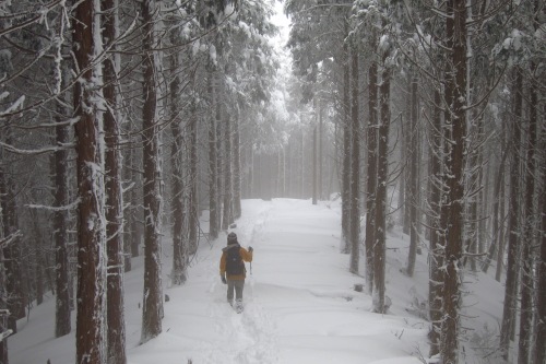
The pink tape led me up through the destruction zone, but the path was up to my own intuition. Scrambling, ducking, hopping, and squeezing were all executed to perfection, but this obstacle course was also eating into precious time. Eventually I did reach Inyo falls, where the path became much easier to pick out, but not much simpler to navigate. A series of river crossings ensued, with each becoming trickier to pick up. Signposts were few and far between, and even with the GPS I struggled to navigate the constricted gorge. The only thing on my side was the weather: I was down to short-sleeves and the water was tepid due to the mild temperatures, making the inevitable slips into the stream more bearable.

ebo4

Higher and higher I rose, double checking landmarks with both the GPS and the paper map. After ninety minutes of endless climbing, Matuo waterfall presented itself in all its glory. The water flowed down a thick rock slab like a wedding veil dropping from the cranium of a new bride. The end of the climb was in sight, or so I thought.

ebo7

Twenty minutes after scaling past the last waterfall, the trail terminated at a dirt forest road ringed by rows of cedar trees. It never fails to amaze me how these forest workers can built roads into such inaccessible places. I stopped for a brief lunch, trying to fuel up for the final climb. I still had 300 meters of vertical elevation and 40 minutes until the summit. It was 2pm and I needed to be up by 2:30 if I wanted to make it back before dark.

ebo6

I pushed on, traversing as the trail climbed steeply towards the ridge. Ropes made the tricky footwork more manageable. Through gaps in the trees I spied a towering boulder jutting out of an adjacent peak. This must surely be Uboshi rock, I thought, and knowing that the summit was now in view gave me a much-needed boost. After hitting the ridge, the path climbed straight up towards the right edge of boulders, with more ropes in place to aid in the fight against gravity. I reached the top of the rock and turned right for several more minutes of ascending until finally popping out on the high point at 2:30pm.

ebo10

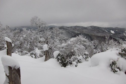
The summit itself was eclipsed by trees, but a small gap to the north offered vistas into Takada village at the base of a series of rolling mountains flanking the Kumano Kodo. Mt. Eboshi is one of the Shin Hyakumeizan, and someone with a sense of humor had scratched out the Shin (新) kanji so it appeared as if Eboshi were on the list of 100 Famous Mountains. While it is a fine peak, I couldn’t help feeling disappointed to do all of that climbing only to be met by a forest road.

ebo11

I did not linger long on the summit, retracing my steps to the base of Eboshi rock. There’s a ladder and chains in place for people to climb the rock, so I indulged myself by resting on the slab and taking in the excellent views out to the Pacific Ocean. This would be an amazing place for a bivouac in good weather. Perhaps future climbers can heed my advice if they dare to follow my footsteps.

ebo8

My original plan was to retrace my steps back into Higashi-no-tani, but the state of the trail had me abandon that option and aim for Hontani (本谷), the headwaters of Nachi falls. I retreated back to the forest road and continued heading west, past the junction for Higashi-no-tani and into the unknown. The road was washed out in several places and after 15 minutes of walking I found a poorly-marked trail shooting off into the forest on my left. I cross-referenced with the GPS and dropped down into a creek bed lined with cedar trees. This creek shot me out onto another dirt forest road which I mistakenly followed up the valley for several minutes until realizing my error. Back to the junction I retreated, eventually picking up the path again after a bit of frantic searching. Here I offer some advice to the Wakayama Prefectural Government: spend less time building roads to nowhere and more time marking your trails clearly. This is supposedly a World Heritage site after all.

ebo9

The dense forest blocked out the light, giving amble warning that nightfall would soon be approaching. I picked up the pace, flowing past a series of other streams flowing in from both the right and left. Eventually I reached San-no-taki (三の滝), where the trail climbed up steeply to the base of an enormous cryptomeria tree nearly a thousand years old. Just on the other side of this giant, a series of stone steps as old as the trees led me to the base of Ni-no-tani (二の谷) with its emerald green pool. I paused here, taking in the scenery and refueling the body. San means ‘three’ in Japanese, while ni is for ‘two’, so where is waterfall number one? A quick study of the map revealed the answer, for I was sitting just a short distance from the top of Nachi falls, the first waterfall. Now it all started to make sense, as in the old days the esoteric monks would climb up here and perform their aesthetic rituals at all three waterfalls. Legend has it that some of them would even leap over the 133 meter drop of waterfall number one in the ultimate path to spiritual awakening.

ebo12

Nowadays, visitors are forbidden from entering the area above Nachi falls, as that’s the domain of the gods. There is a shimenawa rope strewn across the falls, so I’m sure that plenty of shrine staff come up here to restring the rope from time to time. From here, there was one final steep climb up a series of stone steps to a mountain pass that revealed views down to the shrine near the base of the falls. The end was finally in sight. A few minutes later, I found myself at the 3-storied pagoda overlooking the falls. The final step in my trip was to find the bus stop.

ebo13

I followed the signs as best I could, but after one false turn I ended up at the top of Daimon-zaka, a stone-lined hill situated along the Kumano Kodo. I had come here just two months after my heart surgery and fondly remember climbing this slope with Kanako. Since I knew there was a bus stop at the bottom, I simply went down Daimon-zaka. This is one of the most popular parts of the Kumano Kodo, as day-trippers can easily make it up here to the falls and back before heading back to their hot spring hotels along the coast. However, on this late afternoon on a cloudy Monday, there was no one around to spoil the scenery. It was the ideal way to end the hike, and I arrived at the bus stop at 5pm, with just 15 minutes to spare before the bus back to Kii-katsuura and the final train back to Osaka at 6pm.

ebo15

It was an epic adventure, but not one I want to repeat anytime soon. I’m getting too old for these kind of things, and I really just want to get the last 9 peaks finished so I can start leading a more relaxing life and devoting time to raising a family. Am I finally growing up after all these years?

Read Full Post »

Mt. Sajiki – Sinking In

On the outskirts of Kyoto city sits the tiny, forgotten hamlet of Kumo-ga-hata. The village punctuates a secluded valley at the base of Mt. Sajiki, the source of the Kamo river that flows through the center of the city on the meandering journey to Osaka bay far to the south. It was here that the bus dropped of several dozen elderly hikers on a brisk January morning. Among the flood of pensioners elbowing each other off the bus, Kanako and I slipped out and sorted through our gear. The streets were bone dry, an indication that the snow depth on the ridge may be a lot thinner than initially expected. We stashed our snowshoes behind an abandoned storage building and worked our way up the steep forest road towards the trailhead. We were anxious to get a quick start ahead of these unusually large groups before they turned the hiking path into rush hour gridlock.

sajiki1

The route to the start of the path would take us right past Shimyoin temple, a place that Ted insists is one of the ‘must-sees’ of Kyoto. As Kanako and I headed up the concrete, we noticed a small signpost pointing towards Mt. Sajiki on our right, well before the mountain pass. We took this spur, thinking that it must be the correct way up the mountain. The path disappeared under a blanket of snow, but the route was easy to pick up as a rut in an otherwise nondescript cedar forest. Upon reaching the ridge line further up, we realized to our horror that this was a shortcut trail built by lazy hikers trying to shave off a few precious minutes from the long hike. We were further north along the ridge, over a kilometer from the temple both of us were longing to visit. We could simply visit on the return journey, we surmised, continuing our climb into the ever-deepening snow drifts.

sajiki3

We were following a well-trodden path that led through a mixed deciduous forest of trees weighed down by a swath of freshly accumulated snowfall. Progress was swift until we reached the rear of a thirty-strong pack of elderly hikers, the same ones who had alighted the bus. They must have pushed ahead of us while we were dallying around on our ‘shortcut’ path to the ridge. Upon seeing us, they stepped aside and motioned for us to move ahead. The traffic jam was thus avoided, but it led to another unexpected problem.

sajiki2

Being at the front of the pack meant that we would be breaking trail through knee-deep snow. Whose idea was it to leave those snowshoes back at the bus stop?

sajiki4

Progress ground to a halt as Kanako and I took turns burrowing a path for the pensioners. Perhaps they should have paid us for our unheralded sherpa services. Tape on the trees helped with pathfinding until reaching an exceptionally broad lane flanked on both sides by forests of cedar. There must certainly be a concrete forest road buried somewhere under all of this powder, I surmised, studying the map for further confirmation.

sajiki7

A bit further along the track sat an abandoned Daihatsu 4-door hatchback, the license plates long stripped away and left to rot like the fruit of a persimmon tree. Here a group of hikers met us from the west, via an approach that few others use even in the green season. We breathed a sigh of relief as they offered to do the trail-blazing from here to the summit. We reached the crest of a long incline that felt very much like a high point. The problem was, everything was buried under a meter of packed snow. I continued along the ridge for a bit until I heard shouts behind me. Retracing my steps, I had discovered that the other group had dug down with their hands until finding a concrete triangulation point.

Mt. Sajiki, peak #49, was knocked off with relative ease, thanks in part to the other hikers who seemed to know the mountain better than most. I would shutter to think how Kanako and I would have fared completely on our own. Ted and I would find out the answer to that question exactly one year later, fighting for our lives on a peak just a few kilometers due east of here.

sajiki6

We never did make it to Shimyoin temple, having to bypass the sacred grounds in order to make the last bus back to Kyoto. Perhaps Saijiki is worthy of another visit, if anything to confirm that we actually made it to the summit after all.

Read Full Post »

A Meizan Fit For Offspring

If you could name your newborn after one of Japan’s Hyakumeizan, which one would you choose? Tsurugi would be an obvious choice for a male, but just wouldn’t be suitable for a daughter. Such is the dilemma of meizanologists who are fascinated with mountain climbing and nature.

Fuji, Hotaka, and Ena could be considered lovely names for Japanese children, but just don’t fit kids born from multi-national parents. But wait…….there is indeed one of the Meizan that does indeed sound foreign, especially when the first two syllables are abbreviated. And low and behold, it is right here in Kansai.

So I present to you, the latest addition to the Tozan Tales family. You may call her by her Japanese name, or the fitting abbreviation ‘Eve’

IMG_7649


Read Full Post »

It’d been nearly a decade since I last set foot on the Kumano Kodo, but here I find myself on my second outing in less than a week. It was time to visit Mt. Obako, one of the 200 Famous Mountains and the highest peak along the Kohechi pilgrimage route connecting the shrines at Hongu with the temples of Koyasan. The Kohechi is the shortest route to Hongu, but what it lacks in distance it more than makes up for in height, with three mountain passes over 1000 meters in elevation. Obako pass surpasses the 1300-meter mark, making it one of the highest points in all of Wakayama Prefecture.

obako1

This time around I was joined by my old friend Nao, a fellow Kansai 100 seeker and Hyakumeizan alumnus. In the passenger seat sat Nao’s enthusiastic wife Tomoko, an old friend Aki, and Indonesian hiker extraordinaire Dewi. It was a quintet with a thirst for adventure, and a most welcome convoy for my quest on mountain #90. Nao’s 4-wheel drive hatchback rolled up to my doorstep shortly past 6:30am on a bitterly cold Sunday morning. The temperature in Osaka city sat at zero degrees, a rarity for this relatively mild marine metropolis. We set the navigation for Nosegawa village nestled in a secluded valley on the southern flank of Koyasan’s idyllic mountaintop monastery.

obako3

Though less than 100 kilometers from the city center, access to Koyasan is anything but swift, as the only road to the top is laden with narrow shoulders and serpentine switchbacks. The pre-dawn black gave way to ash gray cloud as we inched closer to the summit. Snow swirled from the heavens and began settling on the frosty asphalt, transforming the landscape into a scene out of Fargo. Once we hit the Koya-Ryujin Skyline road the thoroughfare had turned into a giant bobsled run. The snow tires were effective enough, but progress ground to a halt on the far side of Koya, as the route dropped to the river bed running alongside the sleepy village of Omata, our starting point for the climb. While only twenty kilometers from the temples of Koyasan, it is a full-day journey on foot if using the Kohechi. A hotel further up the valley promises a warm bed and soothing hot spring to all pilgrims, the only plausible accommodation in a tiny hamlet lost in time.

obako4

Five centimeters of dry crystalline powder greeted us at the trailhead. It was hardly enough to justify carrying the snowshoes, but the crampons went into the kit as a precaution. I led the way as the meandering route immediately began the fight with gravity through a dense cedar forest. Footprints of a variety of mammalians crisscrossed the route intermittently: those of the deer, boar, stoat, and rabbit were most easily recognizable. The first forty-five minutes were a sweaty, relentless climb that got the blood flowing, and soon a small rest shelter presented itself at the top of a small rise.

obako2

The hut was unlocked and provided a welcome escape from the howling winds and subzero temperatures holding Mt. Obako in its grasp. The GPS read just a hair under 1000 meters – halfway there as far as the climb went, but a fraction of the distance horizontally speaking, as there were still over 4000 meters to cover before the summit.

obako5

Aki and I waited for the others to catch up. This climb was in stark contrast to last weekend of being exhausted from the heat. The Siberian temperatures had me moving remarkably fast, as the clean air cleansed the lungs. Once Nao, Tomoko, and Dewi joined us at the hut we were itching to get back on our feet. The next part of the ascent towards Hinoki Pass skirted the edge of a series of unnamed peaks that overlooked a valley of hardwoods. The path itself resembled a forest road that can be found on virtually every mountain in these parts, and the planted cedar gave a hint that I was probably not too far off. The question arises then: was the logging road built directly on top of the ancient pilgrimage route, or was the route relocated here after the road was built?

obako10

The angle eased a bit as we inched closer to the ridge line. At one point the trail was roped off, sighting typhoon damage from several years ago. A detour lead up a sharp incline to our left. I led the way but the going was tough without crampons. The others put on their climbing irons as I signaled to climb up the closed trail, as the angle was easier on the feet. Both routes met up at the ridge anyway. While waiting for the others to catch up, a small break in the clouds offered a chance to polish off the lens.

obako7

We followed the ridge for a short distance through a section of old growth forest glistening with rime frost. It’s a shame that more of the natural beauty of the deciduous groves was not spared in Japan’s post-war frenzy for cheap wood. Arriving at Hinoki pass, I broke out the candy bar stuffed near my underarm to keep it from freezing. It was already approaching noon, and the ridge was no place for a lunch break, as it bore the full strength of the howling gales. To our left, the pyramidal shape of Mt. Obako’s noteworthy summit came into view, though it was still a good two kilometers away from our current position. Instead of sticking with the ridge line, the Kumano Kodo follows yet another logging road built on the far side of the valley. Perhaps they should consider renaming this route the Kumano Rindo.

obako6

I blazed a trail through the shin-deep powder, sinking into a steady rhythm that left the others far behind. I much prefer this type of hiking anyway, as the silence and serenity allows a chance to ponder my thoughts and to fully appreciate the beauty of the mountains. Even though this was just another forest road, the snow transformed what would normally be just another boring road walk into a thing of magic.

obako9

The route lost around a hundred vertical meters of elevation over the next kilometer or so until finally bottoming out at the base of the long climb to the summit. Again I waited for the others to catch up while refilling my water bottles and finishing off the chocolate. At last we had reached the main junction just below the final climb. Turn left here and you can continue on the Kumano Kodo to Obako pass, where you’ll find a free emergency hut and toilet facilities.

obako11

To the right lay a long 14-km path to Mt. Gomadanzan, the nearest civilization from this remote location. Straight ahead, through a mystic forest of towering beech and oak, a scenic path lay buried in a thicket of snow sculpted by the winds. It was like hiking through a frozen ocean of breaking waves: once through the knee-deep crests you’d scuttle along a thin layer of ice before hitting the next wave of powder. I took the lead again, leaving the others in the dust as I finally got into the zone. It was only 600 horizontal meters to the summit and I wasn’t about to stop for any reason. I needed to generate as much heat as I could as the summit sat on a patch of bald grass completely naked to the elements.

obako13

I didn’t bother with the crampons, as they’d offer no traction in this grainy powder. I used my trekking poles in much the same way a nordic skier uses them to facilitate movement, and shortly before 1pm I topped out on the summit of Mt. Obako, my 90th Kansai Hyakumeizan. I immediately sought shelter behind a bush that helped diffuse the wind gusts and I once again waited for the others to arrive. Lunch consisted of a thermos of piping-hot vegetable soup Kanako had prepared the previous evening. It was exactly what I needed to keep me going on the return journey. Once the others arrived, summit proofs were taken and praises offered: for not only was it my 90th peak, it was Nao’s magic #70.

obako12

After lunch, we retreated back into the woods. Our original plan to check out the hut at Obako pass was abandoned in favor of saving time, so we simply retraced our steps back to the junction. Forward progress was catalyzed with the assistance of gravity, and once back at the junction I waited yet again for the others to catch up. From here I set off in front but kept the pace gradual so I could still be in earshot of Dewi and Aki. I wanted to pick Dewi’s brain about Mt. Nenotomari, a peak that was still on my list and one that she had happened to climb back in December. It turns out, like the remaining 10 mountains on the list, that the climb itself is simple enough, but access throws up the biggest challenge. She offered the name of an acquaintance that lives in Shingu who may be able to offer a ride to the trailhead.

obako8

Once back at Hinoki pass, my pace accelerated as I decided to just wait back at the rest hut for the others to catch up. It was a wise decision, as the weather had turned and light snow began to fall. The hut was the perfect chance to finish off the rest of the culinary reserves while giving the knees a much-needed rest. Back at the summit, I had lent my winter mountaineering gloves to Devi as she had lost all feeling in her fingers. My hands were doing just fine as I now carry three layers of thermal protection for my sensitive fingers. There would be no more frost nip if I could help it. She returned the gloves back at the hut and I offered her some tips to keep the phalanges intact in winter pursuits. Frostbite and hypothermia are the two biggest challenges for winter mountaineers, especially on days such as today. We all returned safely back at the car just past three in the afternoon after spending nearly six hours in Kansai’s version of Siberia.

Read Full Post »

After retracing our steps back to Tamaki shrine, I bade Andrew and Rick a farewell before ducking into the forest towards Hongu. We had agreed to reconvene around 3pm at Sanzai pass, a distance of roughly 12 kilometers to the south. The path skirted the edge of a rock formation directly below the summit of Mt. Tamaki while climbing gently towards a mountain pass. Upon checking the GPS, I realized to my chagrin that I was indeed heading in the completely opposite direction. Perhaps the staff at the shrine could invest a little more energy into making those signposts a little less confusing.

Go7

At the far end of the shrine, a signpost did indeed point the way towards Hongu, so I quickened the pace to make up for lost time. The path dropped hard, reaching a paved forest road in about half an hour. Two wooden benches sat on the shoulder, glistening in the warm sun like a pair of poolside armchairs. I plopped down on one of them, digging into my gear for some nourishment that would sustain me for the long climb ahead. The trail marker indicated that Mt. Oomori, the next summit on the route, was still over 4km away. A further study of the map revealed that the summit was indeed higher than Tamaki, so I had my work cut out for me.

Go1

The route paralleled a gravel forest road through a monotonous grove of farmed cedar and cypress. Across the valley, between gaps in the evergreen needles, Mt. Tamaki dominated the skyline but still looked uncomfortably close. Just off the trail, a gray squirrel jumped from tree to tree, obviously startled by the sight of a thru hiker so late in the season. After leaving the forest road, the path made a beeline for the ridge, as if the generations of pilgrims had completely ignored the topography. Sweat rolled down my brow as I shed off layer upon layer of thermal protection. The soft-shell and down jacket were complete overkill and did nothing but add a burden to the bulging pack. Upon hitting the ridge, I collapsed in a heap of exhaustion, once again reaching into the stash of edibles to fuel the engines. The summit of Oomori came a few minutes later, followed by a monster of a drop that had my left patella screaming in agony.

Go2

Once bottomed out, I mentally prepared myself for the long haul up to Mt. Godaison, a mountain apparently named after the Five Wisdom Kings of Esoteric Buddhism. The path followed a narrow cliff edge blanketed with exposed tree roots, an angle so pronounced that those same roots doubled as handholds. At the top of the first pinnacle, the path dropped just as dramatically on the other side, sending shockwaves through my already taxed knees. The process repeated itself several times over, until reaching the top of a nondescript crag watched over by the menacing gaze of Fudō-myōō. I had officially reached the high point, but the fun was far from over. The path dropped yet again and climb another spire or two before a signpost had indicated that I was indeed standing atop the southern summit of Godaison. Perhaps this peak was not only named after the Wisdom Kings, but also after the quintet of rocky escarpments laid across the back of the massif. This mountain must have quite the profile when viewed from the valley floor.

Go6

Running on empty, I could do little other than let gravity takes its course. If I stopped now I was afraid I wouldn’t have the strength to get back up. Feeling lightheaded was an indication that I was in dire need of a break however, so at the next junction I collapsed and stuffed a fistful of trail mix into my mouth. I had lost quite a bit of salt on the walk and needed to replenish. I usually carry some salt candy during the hot summer months for this very purpose but had no idea such countermeasures would be required in January. I felt a little better after a 10-minute break, but was beginning to worry a bit as I was down to my last 500 ml of water.

Go5

I had one more peak to climb between my current position and the parking lot where my support team would pick me up, so I took a deep breath and slow, deliberate steps towards the top of the forested hillside above. The phone soon rang, and it was Andrew letting me know that he would be arriving at the pass in a few minutes. I pushed on, driven by the desire to see this long journey come to an end. Once past the last peak the route dropped quickly, skirting past a couple of electrical towers that would surely have Kukai spinning in his grave.

Go8

The GPS showed the paved road in sight, and that was enough to keep me on my feet, as was the small clearing that afforded picturesque views into the the riverbed.

Go9

Eventually I popped out on the road, where Andrew and Rick offered their support. Hot tea and leftovers from lunch were placed on the hood of the car and I was quickly nursed back to health. I mean, it wasn’t like I was on my deathbed or anything, but I was feeling a bit too gassed for the final three kilometers to Hongu, which we ended up covering in the car.

Go4

The shrine itself is a bit of a letdown considering that it was moved from its original location to a place just off the main road that tourists can more easily access. It kind of ignores the topography and landscape, but the original temple foundations can still be visited in the riverbed below at a place called Oyunohara. In fact, this is where all three routes of the Kumano Kodo converge. The Okugake michi, had I continued to follow it, would have spit me out just across the river in an area without a safe place to cross. In ancient times there were a series of wooden footbridges but they have since been washed away. Perhaps a wade through the river is an appropriate cleanse after capping off a 120-kilometer journey through Kansai’s most rugged terrain.

Go10

With mountains number 88 AND 89 conquered in one fell swoop, it was time to line up the cards and attempt an epic ascent on another of Kumano Kodo’s challenging peaks.

Read Full Post »

Mission Complete

The magic mountain #90 has been scaled. T-minus 10 and counting……

IMG_7341

Read Full Post »