Feeds:
Posts
Comments

Posts Tagged ‘Kyoto’

For the third week running, on the first of April no less, Ted and I find ourselves parked under the plum tree at the Family Mart in Ōhara, stocking up on provisions to not only sustain us on today’s hike, but also for the long drive up to the Oisugi settlement in the upper reaches of Kutsuki village. The previous week, we had driven the car along the forest road to the headwaters of the Adogawa, but this time we park the car across from Omiya shrine at a junction of two crossroads. Our plan is simple: take the left fork and retrace our steps to Nabekubo-tōge and continue our northern hike along the Takashima to Onyū-tōge and follow the old Saba-kaidō back to our car.

We make good time on the drive and arrive at the shrine shortly after 8am, greeted by a plum tree in full bloom. The bare ridge soars above the collection of depilated dwellings in the hamlet, some of which are in desperate need of re-thatching. Upkeep on these traditional thatched farmhouses is extremely costly, so it’s no surprise that most homeowners of limited means simply cover the thatch with a more durable corrugated metal. An informative signboard sits in front of a recently constructed restroom facility, providing yet another relief of the bowels before commencing on the long slog back to Takashima’s hidden ridge.

The hamlet remains quiet and still in the light of the early morning, with nary a soul in sight — though to the trained eye you can just about make out the eyes peering from behind drawn curtains gazing suspiciously at the two masked foreigners marching through their front yard. We reach the trailhead in about 15 minutes, drop the facemasks, and follow the brook upstream toward where we had last left the Takashima. Despite it being a week between our last visit, the trail is hard to pick up in places, but thanks to our digital aid we soon find the correct tributary and reach Nabekubo-tōge (25) about an hour after leaving the car. We turn right, initially accompanied by a dense cedar plantation on our right before the completely natural forest takes over at the top of a steep rise.

Through a gap in the trees, the adjacent folds of mountain ridges appear to be sprinkled with dandruff flakes, but upon closer inspection Ted and I let out a yelp of joy to discover that the hills are ablaze in the brilliant white petals of the mighty kobushi or Magnolia kobus. These stalwart deciduous trees feature a six-fingered glove of bright white flowers covering their upper branches. They are a sight to behold and really do give the cherry blossoms a run for their money for those lucky enough to come across them.

These signs of spring bring a welcome vitality to our walk, and at the crest of our first unmarked peak a green waymark shows a horizontal distance of just 4.8km to Onyū-tōge, our planned departure point. “We could be back at the car by noon at this rate”, exclaims Ted. The Takashima thinks otherwise.

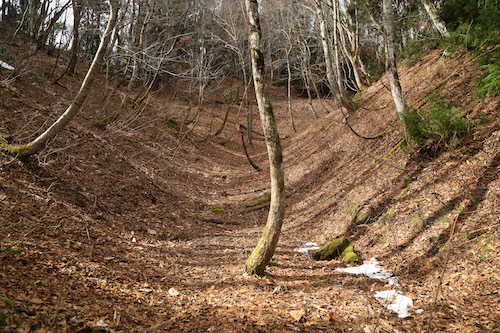
Never judge a route by the horizontal distance to be covered — a vertical elevation profile is a much better way to access a walk. Without such vital information our hike turns into a roller coaster of a ridge walk, as it rises up and over a series of smaller peaks before dropping to a long saddle and turning into what Amber Heard’s lawyer can only describe as a ‘mega’ slog. I turn around and give Ted that all-too-familiar look indicating the start of a big climb. It won’t be the first time that expression is painted on my face on this fateful day.

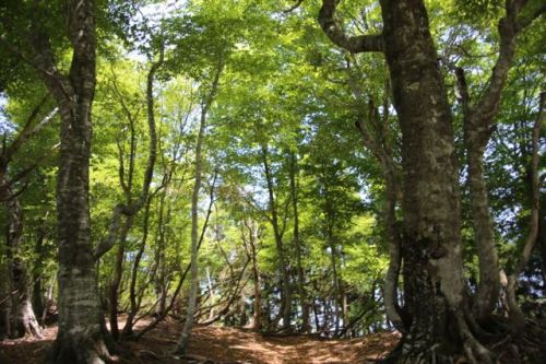
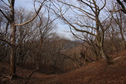
Our conversation peters out to a series of grunts and profanities, mostly from my motormouth as I dig deep within my depleted energy reserves. It is best just to lower your head and work through the discomfort of the straining calf muscles as the feet struggle to continue their upward fight against gravity. The one upside to our muscular torment is that the scenery is second-to-none. Never in my wildest dream would I think that such an untouched and sprawling beech forest snuggles the Shiga-Fukui prefectural border along the central divide. Such spectacular beauty gives us the impetus to continue our forward progress. Giving up would be out of the question.

Even though our pace resembles that of an injured turtle, we somehow reach the summit of peak 803 in less time than indicated on the map. This gain in time, however, is quickly lost as we settle in for a well-deserved mid-morning snack and leisurely break. Once again, Lara comes to the rescue as Ted and I continue to expose each other to new trail nibbles. These all-natural fruit bars satiate our appetite and the caffeinated sports Yōkan helps us ward off the drowsiness caused by the 3am alarm clock. Restored vigor leads to a timely photo opp in the gap between two beech trees joined at the hips.

Our route diverges northwest briefly and drops to a tiny pond marked on the map as Okusuge, though there is nothing in the way of a signpost to indicate an official name for the nearly-dried marsh. Perhaps this area is a bit wetter in the summer season. We skirt around this depression and follow the tape marks as we change directions to the east and head upwards toward yet another unnamed peak. About two-thirds of the way up this slope we pass by an enormous horse-chestnut tree that appears to be home to a bear’s feeding platform. We don’t loiter around long to enough to check for inhabitants.

At the crest of the rise we once again teeter on the sea-saw ridge, taking in the views between gaps in the trees while the talk turns to vaccinations. Japan is about 6 months behind the rest of the world rolling out the inevitable inoculation as we place bets on which will come first, our completion of the Takashima, or our turn at the needle.

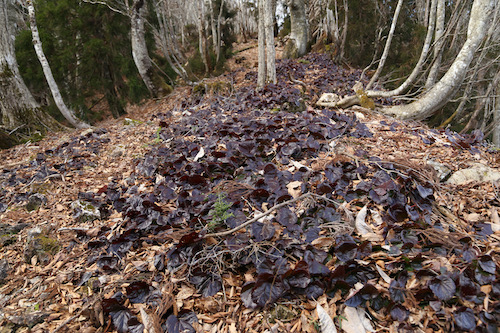
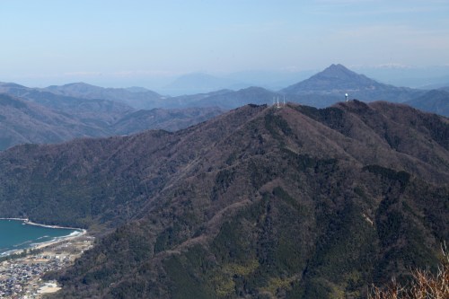
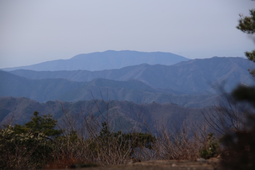
Those dark olive leaves of the diapensia plants that have been accompanying us on our journey finally show us their reproductive parts, as a series of majestic pink petals of the iwakagami flower finally begin to open. We can sense that summer is just around the corner as the rising heat of the late morning coaxes us to roll up our sleeves and make quick work of the ridge. Soon enough we spot a sign of encouragement: 700 meters to Onyū-tōge. I quicken my pace in anticipation of our arrival, only to be thwarted by the abrupt change in grade. It feels as if Ted and I are climbing up the transition of the quarter pipe of the Megaramp. Our only solace is that the vistas have really opened up behind us, revealing the Hira mountains in all of their beauty.

We enter a dry area of crumbly dirt scree sandwiched between groves of giant beech and cedar. Sweat flows freely from our temples as I once again gaze back at Ted in disbelief. If not for the proximity of the mountain pass I would surely like nothing more than to slouch down for a long break. At long last, we reach the top of yet another unnamed peak and find a sign informing us that our break point is just 100 meters to our right. We coast down to the paved road awaiting us at Onyū-tōge (24), the first asphalt crossing of the Takashima (or final crossing if you’re doing this hike in reverse). This would be an ideal place for your support team to greet you with cold drinks and a well-prepared meal but on this particular Wednesday, there is nary a soul in sight.

Instead of breaking here and heading off the trail, we discover that another pass is just a further 700 meters along the ridge, so after walking on asphalt for a few minutes we duck back into tree cover and reach Negorizaka-tōge at 11:35am, well ahead of schedule. This is the junction of the Saba-kaidō or old mackerel road, a route that fishmongers once used to deliver fresh fish to landlocked Kyoto city. We sit next to an old jizō statue and pore over the maps while chowing down on rice balls and other carb-laced delicacies. I remember this pass during my first climb of Hyakuri back in 2014 but never thought I would be sitting here 7 years later contemplating a second round with the mighty beast, but here we are.

Since it is still before noon, I propose to Ted that we should not only ascend Hyakuri this afternoon, but we should also continue along the ridge another 2-1/2km to Kijiyama-tōge, which will put us in good shape for our next stage of the trail. The only challenge with this is that we will have to retrace our steps back to Negorizaka-tōge so we can descend back to the car. Future Takashima trekkers should take note that section hiking this trail with only one automobile certainly is not the most efficient way to do the hike.

I guide Ted along this next section of path, pointing out landmarks that I remember from 7 years ago and giving plenty of warning to the steepness of the climb. With such pleasant weather we can see Hyakuri towering directly above us, which is both a blessing and a curse — for we can see what needs to be done before we can breach the fortress walls. Fixed ropes are a welcome addition as we push on through the lunch hour. We simply lower our heads as the switchbacks continue to steepen and dig deep within our inner strength as we inch toward the panoramic views of majestic summit. We surprise ourselves by popping out on top of Mt Hyakuri-ga-take (22) shortly before 12:30pm.

An elderly gentleman is settled in for a lunch break as we usher a quick greeting. He has climbed from the Fukui side of the mountain and is just as surprised to see us as we are to see him. Despite being three days into our trek, he is the first hiker we have come across, a testament to the remoteness of the Takashima trail and the difficulty of access. Instead of breaking here, Ted and I continue due north and immediately start losing altitude: the beech gives way to cedar and cypress before flattening out on an elongated ridge. We push past peak 711, vowing to have our own convenience store-inspired break on the return. The map indicates a 70 minute journey to Kijiyama-tōge (21) but we reach it in just 45 minutes and pause just long enough to snap a photo before turning around for our re-ascent of Hyakuri.

Peak 711 can not come soon enough as Ted and I settle among the rock formations on our pre-determined break point. I bust out the chocolate while Ted polishes off the afternoon tea bottle and we once again stare at the maps, wondering if we will be able to complete our hike before dark. The one advantage we have is that I know the route we need to take as it is the same descent trail I took back in 2014. After our invigorating snack, we force ourselves to our feet for the excruciating return to the summit. Three hundred vertical meters later, with burning calfs and tingly thighs, Ted and I give each other a high-five back on the top of Hyakuri and really take time to cherish the views. Time check: 2:04pm. We do in 90 minutes what most hikers would usually accomplish in well over 2 hours.

The drop off of Hyakuri is agonizing, but the fixed ropes aid in cushioning our descent. The most demoralizing part of the route is that, once you pass a junction for the Hyakuri Shindō route, you have to climb up Mt Hakuishi before dropping back to Negorizaka-tōge, but three-quarters of the way up, we discover a faint path to our right that avoids the summit and meets up with the track shortly before the pass. We would like to thank the kind animal that forged that path for us, even if it was made by the shapeshifting kitsune.

With no time to waste we immediately turn left at Negorizaka-tōge and bade farewell to the Takashima in favor of the Saba-kaidō. The route parallels a paved road and meets it briefly once, but for the most part we stay in the forest and navigate through a cluster of truly stunning Magnolia kobus trees in full bloom. The late afternoon light illuminates the petals like a spotlight on a stage actor and with no more ascents between us and the car the smiles once again return to our exhausted faces. At the bottom of the valley Ted admits that in his walk of the Saba-kaidō he somehow completely missed this section. Instead, he seems to have spent most of his time bushwhacking up a parallel valley if his memory serves him correctly. The last 20 minutes back to the car is a breeze, and with the fading light of the day we are already strategizing about stage 4 of our hike. For one, we will no longer be required to access the trail from this valley. We can now turn our attention to Aso village at the base of Kijiyama. Can we knock off the next section before Golden Week?

Part 4

Read Full Post »

Mid-March. We can put off this endeavor no longer. The drive northward takes an hour, with an obligatory stopover at the Family Mart in Ōhara for nourishment and lavatory relief. Ted parks the car under a weeping plum tree in the convenience store parking lot and we make good use of the facilities before continuing up route 367 past the Buna-ga-take trailhead and further west on route 781 into the bowels of Kutsuki village. We park on the shoulder of the road, hop over a barrier, and stroll up a gravel forest road while studying the maps on our digital navigation devices. I signal to Ted to turn left on an incredibly steep forest road, which he reluctantly agreesthough his map indicates that following the stream is the most direct approach. We ascend to nearly the top of the spur until I zoom out on my map and realize, to my utter disbelief, that we are actually on the entirely wrong route. In our enthusiasm to hit the trail we had parked the car too early and were following a rather obscure and seldomly used track to Migo-goe (ミゴ越) on the far side of Kyo-ga-take (経ヶ岳). After some consultation, and a reflection upon our arduous track record, we both agree that a wise retreat back to the car is our best bet.

taka1-1

Once back at the vehicle, we indeed find the proper trailhead further along the paved road and park the car next to a farmer’s field near Kuwarabashi bridge. As we walk toward the bridge, a signpost indicates that today’s route sits along the so-called Fairy Trail, a trail-running race that will likely turn you into a fairy should you choose to brave the leeches and summer rains to participate. With the trail-running boom come more and more of these long-distance races that seem to be set up as a way to cash in on the trend. Joining these races will usually set you back at least one Fukuzawa note. If I were into trail running I would just save some money and run the race courses off season for free but I guess the idea of joining a race is to share your misery with fellow-minded sadists. Just beyond the bridge we find a large signpost for the Takashima trail and follow the first few meters of the track up into a damp forest of moss and cedar.

taka1-2

As we work out war up the switchbacks towards the ridge line, the conversation soon turns to self-publishing and the challenges of working with editors and the publishing industry. Since both of us are seasoned authors, with my guidebook and his walking anthology, the enthralling conversation gets our mind off the long climb, taking us up and out of the cedar plantations and onto a wild spur punctuated with the contorted limbs of the Ashiu-sugi trees dotted along the rarely trodden route.

taka1-4

Shrubs of rhododendron and andromeda add a green accent to the hazel tones of the forest floor as the spur gently guides us towards the towering ridge above. To our left, the slopes crescendo abruptly down a ravine choked with years of rock and tree fall, while to our right the contours fall away into Tamba valley and the sounds of a hidden stream flowing through the untouched valley. As the sun licks the trail all around us, we peel off the layers in an effort to speed the evaporation of sweat from our overheated bodies.

taka1-3

The route is liberally plastered with yellow tape reading Takashima Trail, affixed to the tree branches at such regular intervals that would give the Tanabata Festival in Sendai a run for its money. Don’t get me wrong way marks are an integral part of any long-distance trail, but perhaps stringing them every five meters is a bit overkill.  Just below the true ridge, our track converges with the upper reaches of Tamba valley, whose trough is dotted with patches of lingering snow. Fortunately, an unusually warm winter means that we are spared the agony of potholing through the usual thigh-deep drifts.

taka1-5

We reach the junction at Tanbagoe (31), the first of the 31 official Takashima trail posts lining the route. Ted and I pause here and try to imagine what life must have been like in the begone days as travelers used this route to enter Tanba province from neighboring domain of Wakasa. A tea house was erected here in centuries past to provide rest and most likely served as a checkpoint during the more turbulent times in Japan’s feudal history. A famous song, penned by the renowned Enka lyricist Ryūtarō Kinoshita, uses the Tanbagoe as the setting for a lover’s lament:

The Takashima trail heads northwest towards the first peak of Sangoku-dake, but Ted and I instead head south along the main ridge on the Shiga-Kyoto Prefectural border. The path ascends abruptly through a thicket of sprawling rhododendron to an unnamed summit, where route finding becomes a bit tricky. After a bit of a search through the overgrown brush, a careful study of the GPS coaxes us further southeast to the correct route which soon spits us out on a dirt forest road. Even the plantation overlords have made their presence known in these hidden upper depths of Kyoto. Fortunately the route soon leaves this blight and sends us up an impossibly steep slope to the summit of Kyō-ga-dake (経ヶ岳), where we pause for refreshments. A recently erected signpost proclaims that this is post #32 of the Takashima Trail. So much for the Takashima Trail terminating at Kuwahara perhaps this is a new extension?

taka1-6

Instead of continuing past Kyō-ga-dake and into the unknown, we retreat back to Tambagoe junction and return to official Takashima Trail territory, where a dense network of hardwood and conifers envelop the broad ridge of wild golden grasses and withered weeds. To say these hidden heights of Kyoto are untracked would be a disservice: we are completely alone, following the contours of the land as if we are the first ones to ever set foot in this magical paradise. A clearing between lofty trees would make for the perfect filming location if not for the difficult access and lack of amenities.

taka1-8

Armies of great buna, or beech trees, stand guard all around us, whose bare canopies stretch out in open arms towards the cobalt sky. It is these virgin buna groves that accompany us, as passive escorts, on our 80km march to Takashima. Ted and I gaze skyward as these hardwood centenarians demand our attention and respect. Forward progress is slowed as we aim to capture with our memories what cannot be captured through film.

taka1-7

We follow the undulating ebbs and flows of the ridge, through swaths of iwakagami plants, an endemic species of the diapensia family that can be usually be found in abundance in the Suzuka mountains and the highlands of Gifu Prefecture. The pink flowers usually open in late spring, but for now the raisin-colored leaves wait patiently for the spring thaw and the promise of a continued perennial existence.

taka1-9

A junction is soon reached, signposted for the summit of Sangoku, on a side track just off the main Takashima trail to the southwest. We turn here, edging along the top of a slope of verdant fescue grass poking through gaps in the receding snowpack. It has been an unusually warm winter, and the meter-deep snowfields are nowhere to be found, giving Ted and I a sense of relief considering our previous close call.

taka1-10

Shortly after the lunchtime chimes, we arrive at the bear-scarred signpost on the summit of Mt Sangoku (三国岳)(29) and take a well-deserved break in the soothing sunshine. Many hikers mistake the reading of the kanji for Mikuni but the name is apt as it sits on the border of the old provinces of Tamba, Yamashiro, and Ōmi. Now it doubles as the border between Kyoto and Shiga Prefectures and a quick look at our map indicates that our outstretched feet are actually in the northernmost terminus of Sakyō-ku in Kyoto city though we are literally hours away from what would traditionally encompass the border of the city. Over the last century, many smaller villages have been absorbed by the larger metropolitan areas, and even the summit of Mt Norikura in the Japan Alps is under the jurisdiction of Takayama city, though mostly in name only.

taka1-11

We backtrack to the main trail and turn left, following the folds of the ridge until they become enveloped in a blanket of snow. A track to the northeast loops back to the car, so we search around for a signpost or bit of tape for the Takashima, and finally spot one as the route takes a hard left and follows an adjacent spur smothered in twisty Ashiu-sugi. A signpost dangling from its axis informs us that Iwatani-tōge, our intended target, is apparently located in hell.

taka1-12

Pushing forward on the spur, we come across some green netting sitting by the side of the route, apparently ready to be spread over some endangered flora. The area looks neatly manicured, as if someone has been doing a bit of upkeep. Ted and I pause to consult with the GPS as we come to the realization that we have inadvertently stumbled into Ashiu primeval forest, a protected area under the jurisdiction of Kyoto University. Special permission is required to enter the area, so rather than risk an international incident, we retreat back to the dilapidated signpost, double check the map, and make a hard right here on a narrow spur that runs perpendicular to our current position. The spur is hidden by a thick grove of rhododendron and once we push through the first few meters the route becomes clear—we must lose altitude.

taka1-13

And drop we do, along a precarious root-infested track with steep drops on our right. We pick our way through the contorted mess of imposing beech, cryptomeria and oak as it leads us, at last, to Iwatani-tōge (28). We pause for chocolate and study the maps. We’ve got 3.8km to go until the next pass, where a long forest road will lead us back to the car. The alternative is to leave the Takashima and drop to Hōtani and a more reasonable walk back that would save a couple of hours of walking. The choice is obvious as we bade farewell to the Takashima.

taka1-14

A jumbled mess of thick rhododendron groves is our reward for choosing this route. Ted and I both turn to each other about a third of the way down and agree that coming back up this route would not be fun, for it involves a fair amount of route-finding and more time glued to our GPS than to the sights of the actual trail. The sound of moving water gradually comes within earshot as we snake past a gargantuan horse chestnut clinging tightly to the steep slopes. Improvised switchbacks through a carpet of thick cedar needles lead us to the shores of an idyllic mountain stream glistening in the late afternoon sun. Who knew such pristine tracks of land existed so close to civilization?

taka1-15

We turn downstream and eventually meet up with the remnants of an old forest road that takes us back to route 781 and a twenty-minute stroll back to the car. After such an enthralling hike in breathtaking scenery, Ted turns to me with an enticing offer: “Shall we come back next week?”

Part 2 

Read Full Post »

After reading Ted’s harrowing account of a recent ascent of Kyoto’s highest peak, I thought it prudent to give a recap of my groundbreaking ascent up Mt. Minago. Let us enter the vaults and take ourselves back to May 2011. While northern Japan begins to pick up the pieces after the March disaster, I team up with trusty companion John for an excursion into uncharted waters. The Kutsuki-bound bus deposits us in a tiny hamlet awash in late plum blossoms. After crossing route 367, the dilapidated forest road leads to the trailhead at Ashibidani bridge. The kanji, translating as “foot and tail” valley, is soon to live up to its name.

A series of log bridges, over waist-deep waters, ferry us safely up the first set of rapids to a well-defined track on the right bank of the river. Without these fastened crosswalks, it would surely be a foot and tail exercise hopping up, over and most likely through a set of oblong boulders. Some time between 2011 and our current CoVID times, a series of typhoons and floods have swept through the valley, toppling trees with the whipping tail of the wind and kicking away these bridges with their swollen feet. Had I known the current condition of the track, I surely would have given Ted advanced warning.

The footbridges give way to fixed ropes strung across the river at strategic crossing points. That, coupled with generous decorations of pink tape on the trees, mean navigation is merely an afterthought. The wild, untouched valley we climb is truly stunning in its cedar-deprived beauty: these narrow gorge walls are no match for the tree plantation owners, who leave this sliver of untrodden Kyoto be.

Voices in the distance entice John and I to pick up the pace, and sure enough, we soon run into a quartet of young Japanese hikers out on an excursion. We naturally join forces, with John and I taking the lead as we follow the river to its source and then navigate a headwall of towering beech trees still yet to sprout their summer-green cload. It takes nearly an hour of zig-zagging up the final section of track, past swaths of fringed galax in full bloom, to reach the summit of Kyoto’s highest point.

The unmistakable hump of Mt. Buna-ga-take sits directly opposite our vantage point, with the last stubborn patches of snow clinging firmly to the exposed northern slopes. Our sextet clan perch ourselves on a flat patch of summit, chatting away about mountains while sharing chocolate and hot bowls of soup prepared by Aki, the leader of our recently-merged group. We pore over the maps and eye three possible descent routes, neither of which are clearly marked.

Just south of the high point, a signpost marked teradani (temple valley) is affixed to the tree, so we head just right of this and into and down a narrow trail affixed with tape skirting the edge of the scented flowers of an andromeda bush. We switchback down through a section of planted cedar smothered in colored plastic tape. This tape is either to tell the harvesters which trees to fell or which trees to keep. I must confess that I have never seen these genocidal workers in action so I can never be sure what function the tape has other than the break up the monotony of the terrain.

The cedars once again give way to deciduous hardwoods, and after losing a couple of hundred meters of elevation, we reach the log bridges ferrying us back to civilization. From here’s is a simple walk along a gravel forest road lined with yaezakura trees to finally arrive at Taira bus stop.

We exchange contact information with the other hiking group and check the bus schedule. With over an hour to kill before the next ride back to Kyoto, John and I use our thumbs to flag down a ride all the way back to Demachiyanagi. It’s a shame that such a lofty mountain has fallen into disuse and neglect. You would think that someone in the region would care enough to nurse Kyoto’s highest mountain back to health, but perhaps we’ll all have to wait until the entire human population rids itself of its other health problem first.

So there you have it – a brief recap of a hike nearly a decade ago. At that time I was focused on the Kansai Hyakumeizan, and Minago happened to be peak #38 (and technically speaking, my first of the Ōhara 10). Anyone attempting to climb Minago in 2020 and beyond had best heed the advice of Ted and stay far away from the valley of foot and tail, and you will surely lose your footing and end up on your tail (or worse, to a place that rhymes with tail).


Read Full Post »

Iwakura station is but an insignificant little blip on the Eizan Railway connecting Demachiyanagi to the sleepy hamlet of Kurama in northern Kyoto city, but for William and I, it marks the start of a journey into uncharted hills. Hills which once provided a hidden passage between Kyoto and Ōhara before the advent of the automobile. The two of us set off in mid-December for the summit of Hyōtankuzure, a peculiar peak rising to the modest height of 532 meters and included on the list of Ōhara 10. We leave Iwakura under sunny but chilly skies as we navigate the back streets in search of the mountain trail, marked by a faded wooden signpost affixed to a concrete electrical pole by someone with a penchant for wirework.

Hyōtankuzure, or literally ‘toppled gourd’, is one of the more unusual mountain names in Japan, and its origins are unclear, but a local legend reveals that the shape of the peak resembles a gourd split in half and laid on its side, such is the elongated profile of the peak when viewed from neighboring Hieizan. We will be walking along the entire length of the calabash, hoping for some tiny morsels of sweet succulent scenery in this unexplored corner of Kyoto.

Cedar trees as dense as they come soon yield to a deciduous forest recently laid bare by the strong gusts of late autumn – the fallen foliage softens our footsteps along a well-laid path following the contours of the sloping hillside. Through gaps in the bare branches we stand transfixed by vistas looking straight down on Iwakura and further afield to the ridges on the western edge of the city.

A junction is soon reached on the main ridge, where a blanket of fallen pine needles cushions each footstep through patches of quickly melting snow. We turn left, following the tape marks to the crest of the ridge and the summit of our target peak. A small clearing provides a snow-capped glimpse Mt Horai overlooking the valley, while due east the towering face of Hieizan looks tantalizingly close at hand. William and I pause briefly for a mid-morning snack while bathing in the soothing rays of sunlight under the watchful eye of a miniature snowman.

We retrace our steps back to the junction and continue south along a rarely used trail with unmarked junctions fanning out on either side of the ridge. Our map is affixed with the kanji character 迷, indicating that it is easy to get lost, so we use our GPS devices to double-check our gut feelings as to the proper route. We know that the trail meanders in a southernly direction and after passing through a lovely section of lingering autumn foliage the ridge broadens and turns wild, the kind of untouched wilderness you rarely find so close to the city.

Mesmerized we are by the tranquility and isolated feel to the ridge, so we continue climbing a slope directly ahead where the path seems to peter out into a clearing with splendid vistas of the entire city. This is easily one of Kyoto’s best mountain trails, yet so few visitors seem eager to explore anything that hasn’t been written up in the tourist literature. That suits us just fine, as such hidden spots should remain out of reach except to only the motivated few.

On the far side of the clearing we somehow pick up the trail again, ducking back into a hardwood forest with clear signs of recent ursine activity. Some trees get off easy with just a few claw marks, while others are torn apart by a feisty bear with a probable termite infatuation. We are just a kilometer from civilization, but I guess animals don’t care about these things when their stomachs are empty.

Further along the meandering ridge we reach a junction and drop down toward a secluded shrine nestled against the forest. It only takes about 10 minutes to reach the upper sanctuary of Sudō-jinja, built to commemorate the 8th century prince Sawara Shinno. A gravel promenade leads to route 367 and the short walk to Miyakehachiman station. Future hiking parties may find it more rewarding to start from Ōhara and climb along the lesser-explored northern face of the gourd before continuing along the ridge to our finishing point. Just don’t forget to bring the GPS.


Read Full Post »

Mt Ama sits snugly on a elongated ridge between the secluded hamlets of Kurama and Ōhara, a fitting place to start my exploration of the 10 peaks. I alight from the Eizan train under clear April skies and trot through the deserted streets of Kurama to the turnoff for the Tokai Shizen Hodō that provides passage to Shizuhara and beyond to Ōhara.

Yakko-zaka pass is reached in good time, a chance to wipe the sweat from my brow before taking a faint path on my right in the entirely opposite direction of my target peak. An unexplored trail on my map beckons, as in my recent hiking excursions I purposely seek out these smaller, lesser known trails literally off the beaten path. Red tape marks affixed to the trees help guide me through a thick, neglected hardwood forest. Free from any sort of regular maintenance, it soon becomes a fruitful exercise of climbing up, over and sometimes through toppled timbers and head on into a labyrinth of sticky spider webs, quickly reminding me of why I am less-than-enthusiastic about hiking in the early summer.  After a false summit, the path flattens and reaches a stone stupa adorning the summit crest of Mt. Ryūō . Here, through a gap in the trees, I find what I have long sought – a clear view across the valley directly down on Kurama temple. 

Exultation reached, I slither back to the pass for a quick rest before heading on the main path along a broad ridge teeming with new greenery. Mountain azaleas add a touch of pink and purple to the proceedings as I scoot along a deserted trail on unfamiliar terrain. These hidden stretches of northern Kyoto city are truly magical, as even on weekends you’ll be hard pressed to run into other hikers. I continue at a steady pace, slashing spider webs with my trekking poles as Mt Kibune keeps watch across a parallel ridge, with the slender village of Kurama sandwiched between. I only gaze upon this spectacle in small snippets, as the spring foliage has once again begun to fill the gaps between the canopy overhead. A winter ascent of this ridge must truly provide some breathtaking scenery. 

It takes nearly two hours along a very pleasant undeveloped section of forest to reach a small clearing as a lone Japanese hiker sits on a log just opposite Amagatake’s summit signpost. We immediately commence in tozan banter, that familiar mix of peak namedropping and quizzing of climbing experience that encompasses nearly every conversation you encounter over mountaintop lunches. It soon becomes clear that my companion is a very experienced mountaineer, so I hit him up for some local knowledge. “The rhododendrons are in full bloom at the moment, so I recommend taking this route down” explains my guide, pointing to a dotted trail on my map named, appropriately enough, shakunage one. How can one resist the temptation to hike rhododendron spur in the height of the flower season?

Armed with this bit of insider knowledge, I drop off the northern face of Mt Ama and immediately hit a dirt forest road carved into the steep hillside, literally within spitting distance of the top. It’s a bit of a buzzkill to climb a mountain from a long undeveloped ridge only to find such desecration on a more developed face. I stay on the left shoulder of the deserted road, reaching a spur trail to my left that leads to a clearing pierced with an electrical pylon. At least the lack of trees do provide a soothing vistas toward Kyoto to the south.

I retrace my steps back to the road and engage in a bit of hide-and-seek with the trail. I follow a faint path to the east that isn’t marked on either the paper maps nor on my GPS. That inner hunch takes over, and I soon retrace my steps just before the trail begins dropping down the eastern face. If this were a ‘proper’ trail you would expect to see a signpost or at least a tape mark or two. Back at the junction I peer over the crest of the ridge and spot the real trail traversing just below the northern crest. Pausing, I gather fallen tree limbs and erect a barrier over the false trail on the ridge in hopes of preventing future climbing parties from falling victim to the same mistake.

The route follows the contours of the spur before switchbacking through pleasant swaths of mountain azaleas in brilliant shades of pink. I make good progress through the tunnel of vibrant foliage and reach the turnoff for the rhododendron spur, denoted by a signpost affixed to a rhododendron bush in full bloom. My map says the traverse should take about an hour so I slow down the pace and take in the scenery on a section of track completely void of people. In Kansai it’s surprisingly easy to find deserted hiking trails, even on the weekends.

The up down undulations of the spur give the legs an extra workout, but my fatigue is mitigated by the subtle scent of the colorful flowers keeping watch over the track. This year the rhododendron have bloomed early, for I rarely find myself in the hills during the peak season of early June, turned away as I am by the humidity and stifling temperatures. I soon reach another electrical pylon affording panoramic views of nothing but wilderness in all directions. Who knew that such untamed beauty existed in these hills surrounding Ōhara village?

Descent comes abruptly via a no-nonsense, knee-knocking descent back down to a secluded valley. I reach a forest road and turn left and then right, passing directly past the trailhead of Naccho, another one of the Ōhara 10 peaks. I resist the urge to climb for now but know that I must come back here someday to complete my quest. The paved road I follow soon bisects route 367. A bus stop here reveals an infrequent bus schedule I have neither the time nor patience for, so I continue tramping down a quiet lane for close to 90 minutes until reaching Ōhara village, passing by a temple gate just outside the main town in quintessential Kyoto fashion.

With the first of 10 peaks now successfully summited, I pore over the maps to plot a course of action for the remaining 9 mountains of Ōhara. 

Read Full Post »

Nestled snugly in the mountains of northern Kyoto Prefecture lies a peak by the name of Hyakuri, whose kanji represent 100 Li, or a hundred Chinese miles. The Li is an ancient unit of measurement equivalent to about half a kilometer in length, so this mountain refers to the unobstructed panoramic vistas of 50 kilometers in all directions. A clear weather mountain this would have to be, so once again I teamed up with Will, Mai, and Sota for a stable high pressure window in mid-May.

hyakuri1

We started our automobile journey from Demachiyanagi station, heading up the paved switchbacks past Ohara village and deeper into the Kitayama mountains. Just past Bomura village, we veered left and followed a narrow lane past dwellings in shambles and grossly overgrown cedar plantations. We reached the trailhead a couple of hours after setting off from the ancient capital, and aside from a few fallow fields and a handful of houses dotted along the narrow valley, there wasn’t much in the way of amenities. Remarkably, a minibus runs up to this secluded hamlet twice a day to shuttle the residents to the more populated areas of Shiga Prefecture to the east. As Will and company sorted through their kit, I shuffled off to one of the overgrown vegetable fields in order to provide some organic fertilizer. Relieved, I retreated back to the car and shouldered the gear.

hyakuri5

The trail followed a gravel forest road for a short distance before commencing the climb through a lush and healthy deciduous forest alive with the vibrant greenery of a new season. In Japanese, this annual phenomenon is referred to as shinryoku, and it attracts scores of hikers wanting to witness the power of the changing of the seasons before the caterpillars wreak havoc on the freshly sprouted foliage. On the beleaguered slops of Hyakkuri, however, there was hardly a sign of human intrusion, and the path, littered with fallen branches, looked as if no other hikers had been up here in quite some time. I prefer these untamed folds of mountains to the more frequented spires further east. Even on weekends, a lot of Japanese mountaineers tend to be lazy and stick to the slopes with the easiest access.

hyakuri3

The temperatures rose in conjunction with the altitude gain, forcing sweat out of our aching pores along the long, undulating ridge towards the broad summit of our target peak. It had been just a couple of weeks since knocking off Mt. Oike in the Suzuka range, and now that the antibiotics were now finished, I had an usual jolt of energy despite the balmy temperatures. Will, on the other hand, had been swamped with a new school year at his school and was embarking on his first hike of the green season, and the angle of the gradient appeared to be winning. He looked as if had just come out of the shower, while Sota, just shy of his 9th birthday, stuck little breaks in at every available opportunity. Still, these more leisurely ascents were a much-welcomed change from my usual breakneck pace, and with the glorious foliage and mouth-watering vistas, it was hard to wipe the smile off our faces.

hyakuri2

Just before reaching the junction to the Takashima trail, near the top of a long, relentless climb, we took our first real break of the day and fueled up on snacks for the final assault on the 931-meter peak. While it may not seem like much, you should never judge a mountain based on elevation alone, as Ted and I learned so painfully on Jyatani, a mountain scantly 30 meters lower than our current outing.

hyakuri4

We all felt a bit better once the perspiration evaporated and the carbs were converted into glucose. We shouldered the packs and turned right at the junction for the short but steep ascent to the high point. A few fixed ropes assisted in the more abrupt pitches of the beech-lined slopes, and shortly before the lunchtime chimes we basked in the sunshine on my 79th peak.

hyakuri10

The panoramic vistas were inspiring enough, but the lack of shade caused a bit of discomfort. Despite my negligible cravings for a hot drink, I brewed up a cup of steaming coffee to not only give me a bit of a caffeine kickstart, but also to help lower the weight of my pack by using up the reserves of my hot water thermos. I never carry a stove on day hikes, preferring the ease and timeliness of a portable jug of hot water I can pour over tea bags, coffee filters, or perhaps into the lid of an instant ramen container.

hyakuri8

Instead of retracing our steps back on the serpentine ridge, we spied an alternative loop down the old saba kaidō, a disused trade route linking the Sea of Japan to the ancient capital. This required a traverse further south along the Takashima trail that looked like a breeze on the map. Someone forgot to tell those Yama-to-keikoku cartographers about the incline, however, as the contour lines were spaced much too far apart to accurately represent the real lay of the land. We spent the better part of an hour in a tussle with gravity. Will, Mai, and Sota were running low on hydrogen-oxygen reserves, and with no water source in sight, we had to ration the remaining liquids to avoid being caught out dry. At the top of an unmarked peak, the four of us collapsed in a heap of sweat and exhaustion. Completing all 80 kilometers of the Takashima trail must require superhuman effort, or at least the assistance of a few porters who can carry your heavy loads. With no way of getting fresh water along the ridge itself, trekkers are forced to descend the rugged valleys in search of mountain streams.

hyakuri9

The path dropped abruptly to a junction on the remnants of an old forest road, a place called Negorizaka pass by the generations of travellers throughout the centuries. An aging, rotting shelter provided a relatively dry roof for a duo of jizo statues placed here long before hiking was a recreational sport. Adjacent to the structure, a stone sculpted to resemble an index finger stood at head height, the kanji characters carved into the lichen-smothered face too faded to clearly decipher. We had at last arrived on the saba kaidō, or the old ‘Mackerel Road’ as the westerners tend to call it.

hyakuri7

We veered off the Takashima trail here, turning left and following the eroded trail until it spit us out a short time later on a broad, paved lane that is popular with cyclists looking for some additional exercise. It’s a shame that so many of Japan’s old roads have been paved over in such careless manor, but I guess it kind of makes sense if you think about it. If I wanted to built a literal road to nowhere, what better place to start than a path that has already been forged through a rugged tract of mountain land.

hyakuri6

It took about an hour or so to reach the rustic village where we had parked the car. Fitting enough, it was Sota who had a call of nature upon our return, depositing his load in the woods in much the same way that I had christened the trail upon our ascent. With good ole 79 under my belt, I pored over the maps to scope out the next mountain victim before the onset of the rainy season.


Read Full Post »

Frostnip can be a real blow to the psyche. Although the scrapes and bruises from my winter accident have fully healed, the tips of all 10 fingers are still on the mend, making even menial tasks a bit taxing. I needed an emotional boost, and the only remedy was to get back up on that horse and start climbing mountains again. A journey to the far north was in order.

yura1

The Yura river starts off deep in the mountains of northern Kyoto, in the ancient groves of the Ashyu forest managed by Kyoto University. Over the next hundred and fifty kilometers or so, it passes by villages stuck in an Edo-era time warp while meandering north, eventually dumping its emerald cache of pristine waters into Kunda Bay in the Sea of Japan. Near the mouth of this river sits the twin-peaked beauty of Mt. Yura, my target for this balmy March morning.

yura2

In an effort to save a bit of money, I opted for the highway bus to Maizuru city which was just a few train stations east of Tango-yura, the starting point for the long climb up the northern face of the mountain. The bus soon became a victim of the morning rush hour traffic in the city of Takarazuka, arriving in the port city of Maizuru far to the north nearly 45 minutes behind schedule. Fortunately, there was a train leaving in just a few minutes, so I ran up the escalator and onto the platform just before the doors closed. Trains are few and far between on the Tango railway: locals usually keep copies of the train timetable in their pockets in order to avoid the lengthy wait times between trains. The train pulled into Tango-yura station shortly after 11am under crystal clear skies and a relatively low pollen count that usually keeps me sidelined during the spring.  Mt. Yura dominated the skyline to the south and rightfully so: though only 640 meters in height, it rises straight from the sea just a few meters from the train platform. Looks like I had my work cut out for me.

yura3

The first fifteen minutes were along a narrow paved roadway that terminated at Yura-sō, a beautiful lodge affording wonderful sea vistas and mouth-watering crab during the colder winter months. Tempting as it was to stay the night, the day mission meant that loitering was kept to a minimum, and directly behind the lodge a small wooden kiosk marked the entrance to the mountain path. In this information booth there was a notebook filled with messages from other visitors, as well as a wonderfully composed hiking certificate on A5 cardstock that was free for the taking. I put one in my guidebook as a keepsake, knowing I’d likely be pressed for time on the descent in order to make the next available train.

The path immediately entered a severely eroded gully with chest-high ruts that made for an unexpected workout. The steep contours meant that the woods were free from the grasp of the forestry authorities who have a penchant for destroying the ecosystem by planting cedar trees. The first couple of stage points were checked off in no time at all, but, like most other dormant volcanoes, the mountain angle grows in direct proportion with elevation gained. It was in these thirty degrees slopes about halfway up the mountain that the cedar trees made an appearance, blotting out the light and transforming the forest into a standing army of long-legged evergreen soldiers ready for battle. Their main weapon came in the form of a thin yellow powder that would be released from the needles at the slightest touch of a breeze. This powder causes a severe allergic reaction to those unlucky hikers whose immune systems have been sensitized to the usually benign substance. I reached into my pack, pulling out my pollen mask as a shield against the aerial assault.

yura5

Fortunately the cedar army was a small one, and further up the peak the deciduous paradise returned, revealing swaths of unmelted snow that hung firmly to the harsh contours just below the summit ridge. Crampons were not necessary in the mild March sun, but kick-stepping added an additional level of security as the saddle between the peaks was finally breached. The western peak (西峰) was the higher of the two, so I turned right and followed the gentle curves of the bamboo grass-lined ridge through a grove of beech and oak still naked of leaf after the long, harsh winter. The vistas opened up towards the north of the summit, revealing the long sandspit of Amanohashidate that attracts hoards of tourists throughout the year. I was getting my own bird’s eye view, but without the chaos of the crowds.

yura6

I retreated back to the junction and onto the east peak (東峰), where the panoramic views really opened up. I crafted a seat out of a bundle of dried bamboo grass and soaked up the scenery. To my left, the sea extended uninterrupted out to the horizon. Turning clockwise, the mouth of the Yura river cut a line in the earth directly below, as a twin-peaked cone jutted out of Wakasa Bay like a miniature version of Mt. Fuji herself. In fact, the local nickname for this mountain is Wakasa-fuji, but most people know her by the name of Mt. Aoba, a peak that was still remaining on the list. Behind Aoba, you could just barely make out the snow-capped peaks of the Japan Alps spread across the hazy horizon like a chain of paper snowflakes hung in a kitchen window. Weather this fine is a rarity along the Sea of Japan coast, and if not for that afternoon train I could have easily lazed here until the dawn glow of the following morning.

yura7

As it was, I had planned to catch the 4:29pm train, so time was of the essence. Retracing my steps was simple enough, as I covered the knee-knocking slopes in a fraction of the time it took to ascend. Back on the train, the full effect of my exposure to the pollen let itself be known, with waterfalls of clear snot dripping freely from my poker-red nose. I popped an antihistamine and drifted off in a dazed sleep for the train journey back to Osaka.

yura9

Summiting Mt. Yura, mountain #55, was the confidence boost that I needed. The fingers held up surprisingly well and if I keep my hands covered with soft, thin gloves they don’t cause too much trouble. Pollen, on the other hand, was my real nemesis, but with the momentum on my side, a couple of more mountains in the mighty north had my name on them.

yura8

Read Full Post »

Mt. Sajiki – Sinking In

On the outskirts of Kyoto city sits the tiny, forgotten hamlet of Kumo-ga-hata. The village punctuates a secluded valley at the base of Mt. Sajiki, the source of the Kamo river that flows through the center of the city on the meandering journey to Osaka bay far to the south. It was here that the bus dropped of several dozen elderly hikers on a brisk January morning. Among the flood of pensioners elbowing each other off the bus, Kanako and I slipped out and sorted through our gear. The streets were bone dry, an indication that the snow depth on the ridge may be a lot thinner than initially expected. We stashed our snowshoes behind an abandoned storage building and worked our way up the steep forest road towards the trailhead. We were anxious to get a quick start ahead of these unusually large groups before they turned the hiking path into rush hour gridlock.

sajiki1

The route to the start of the path would take us right past Shimyoin temple, a place that Ted insists is one of the ‘must-sees’ of Kyoto. As Kanako and I headed up the concrete, we noticed a small signpost pointing towards Mt. Sajiki on our right, well before the mountain pass. We took this spur, thinking that it must be the correct way up the mountain. The path disappeared under a blanket of snow, but the route was easy to pick up as a rut in an otherwise nondescript cedar forest. Upon reaching the ridge line further up, we realized to our horror that this was a shortcut trail built by lazy hikers trying to shave off a few precious minutes from the long hike. We were further north along the ridge, over a kilometer from the temple both of us were longing to visit. We could simply visit on the return journey, we surmised, continuing our climb into the ever-deepening snow drifts.

sajiki3

We were following a well-trodden path that led through a mixed deciduous forest of trees weighed down by a swath of freshly accumulated snowfall. Progress was swift until we reached the rear of a thirty-strong pack of elderly hikers, the same ones who had alighted the bus. They must have pushed ahead of us while we were dallying around on our ‘shortcut’ path to the ridge. Upon seeing us, they stepped aside and motioned for us to move ahead. The traffic jam was thus avoided, but it led to another unexpected problem.

sajiki2

Being at the front of the pack meant that we would be breaking trail through knee-deep snow. Whose idea was it to leave those snowshoes back at the bus stop?

sajiki4

Progress ground to a halt as Kanako and I took turns burrowing a path for the pensioners. Perhaps they should have paid us for our unheralded sherpa services. Tape on the trees helped with pathfinding until reaching an exceptionally broad lane flanked on both sides by forests of cedar. There must certainly be a concrete forest road buried somewhere under all of this powder, I surmised, studying the map for further confirmation.

sajiki7

A bit further along the track sat an abandoned Daihatsu 4-door hatchback, the license plates long stripped away and left to rot like the fruit of a persimmon tree. Here a group of hikers met us from the west, via an approach that few others use even in the green season. We breathed a sigh of relief as they offered to do the trail-blazing from here to the summit. We reached the crest of a long incline that felt very much like a high point. The problem was, everything was buried under a meter of packed snow. I continued along the ridge for a bit until I heard shouts behind me. Retracing my steps, I had discovered that the other group had dug down with their hands until finding a concrete triangulation point.

Mt. Sajiki, peak #49, was knocked off with relative ease, thanks in part to the other hikers who seemed to know the mountain better than most. I would shutter to think how Kanako and I would have fared completely on our own. Ted and I would find out the answer to that question exactly one year later, fighting for our lives on a peak just a few kilometers due east of here.

sajiki6

We never did make it to Shimyoin temple, having to bypass the sacred grounds in order to make the last bus back to Kyoto. Perhaps Saijiki is worthy of another visit, if anything to confirm that we actually made it to the summit after all.

Read Full Post »

Climbing the Kansai 100 is a game of numbers. At first you start counting up from zero, checking the peaks off the list in a simple task of arithmetic, but once you pass the halfway point you eventually start counting down to zero. This usually occurs once you hit the magic #70, when the end is in sight and you can start calculating in terms of dozens instead of quarters. In addition to keeping tally, one look at the list will reveal a completely different game of numerals involving the names of the peaks themselves. Out of the list of 100, there are 14 peaks whose names feature some sort of Chinese character representing a numeral. Perhaps the most well-known on the list include Mt. Rokko (六甲山) in Kobe and Mt. Nijo (二上山) in Nara. In the northern part of the region, we have the peak of 7 heads (七々頭ヶ岳), the mountain of 33 intervals (三十三間山), and the crag of 100 hamlets (百里ヶ岳). On the menu for today was the mountain of 8, known in Japanese as Hachigamine (八ヶ峰).

hachi1

Tomomi and I headed north out of Kobe in the rental car, flying on the expressway that cut through Sasayama and into the mountainous region east of Fukuchiyama. The highway lay deserted, sans a convoy of military jeeps shuttling personnel to the bases in Maizuru. Our target peak lay in the central part of Kyoto Prefecture, just west of the Ashu forests managed by Kyoto University. Although there were trails to the mountain from the south, we chose to access the peak from the north and alighted the tollroad at Takahama interchange in Fukui Prefecture.

hachi2

It was mid-April, and here in the sheltered highlands, the cherry blossoms were in full bloom, with petals floating through the soft breeze of the pleasant trade winds signaling a start to early summer. The drive took several hours, and one particularly stunning stretch of trees spanning several kilometers caught our eye. We parked the car at the entrance to a sleepy village and spread a blanket amongst the row of trees, partaking in the traditional Japanese custom of ohanami, or cherry-blossom viewing.

The area lay completely quiet, the denizens either tucking quietly into their lunch boxes in the comforts of their sheltered homes or working away steadily in the fallow fields, preparing the soil for the upcoming rice planting. We sat alone, taking in the scenery while enjoying our lunch in peace. In rural areas, the villagers rarely take time off from their busy agricultural schedules to take in the flowers, instead choosing to admire them from afar. This is in stark contrast to the urban areas, where socialites flock to the parks for an indulgent picnic of junk food and booze. Cherry-blossom viewing parties are considered an integral part of Japanese culture and indeed they are, if not confined exclusively to Japan’s cities, where the majority of the population reside.

hachi4

After lunch, we hit the road again, passing by a group of three children of elementary school age who, after spotting me in the passenger seat, shouted in unison with the familiar jargon “gaikokujin da” (look, it’s a foreigner), which set Tomomi off in bursts of uncontrollable laughter. Apparently the locals were not accustomed to seeing visitors from other countries in these parts, as they did a double-take each time our vehicle strolled past. It was a throwback to the days after the war when the country really opened up to outside influence.

hachi5

The car navigation was set to Gonami pass, where we would have a gentle 90-minute stroll on an undulating ridge until reaching the summit. There was only one problem: three-quarters of the way up the winding road we hit a wall of snow and could not continue. We parked the car and pulled out the gear, following the snow-covered asphalt the rest of the way until reaching the ridge at the mountain pass. It was already 2:30pm by the time we entered the forest, so we had to increase the pace if we wanted to make it back before dusk.

hachi6

The contours on the map were misleading, as the route immediately climbed to the summit of a peak directly ahead. This was far too early to be the summit of Mt. Hachi, so we pushed on to the pinnacle before losing even more elevation on the other side. We soon left the cedar plantations behind and entered a forest forgotten by time. Beech trees rose gallantly along the untouched ridge and the sound of birdsong sprung to life among the bare limbs of the hardwoods. The unmistakable knocking of a woodpecker caught our ears, punctuated by the rustling of leaves to our left, the sound of a fawn seeking shelter from our unlikely intrusion. Off to the shaded northern slopes of the peak, tufts of snow grasped tightly to the contours like a cat clinging to a velvet drapery.

hachi8

We took a short break at a trail joining the main path from the north. The final push to the high point lay just in front of us, but the snowfield hinted at the caloric workout, so we fueled up in preparation. The rotting snow made for slippery footholds but we managed by taking turns kicking steps into the wet slush. The summit was breached shortly before 4pm and afforded unobstructed panoramic views. My guidebook hinted at the origin of the mountain’s name. It’s not that there are eight peaks on the mountain range, but rather the odd spectacle that eight different provinces can be viewed from the top of the peak.

hachi7

Back before the prefectural system of the Meiji era, Japan was divided into hundreds of provinces whose nomenclature still survives in mountain names and regional delicacies. According to this map from the Edo period, the 8 provinces likely seen from the summit were Tamba, Tango, Wakasa, Tajima, Harima, Yamashiro, Kyoto, and either Settsu or Omi. In the present day, these areas have been merged into the prefectures of Kyoto, Hyogo, Fukui, and Shiga, and on this particular day in April, the views were tinged in hues of yellow due to the  Aeolian haze drifting over from the Gobi. On an exceptionally clear day, hundreds of mountains in every direction can be clearly identified on the horizon, but we settled for a neighboring view of Mt. Aoba before ducking back into the forest toward the waiting car.

hachi9

We arrived before nightfall, having checked peak # 76 off the list. That pushed me over the three-quarters point. For the iconic #77 another mountain with a number in its name seemed worthy of attention. Perhaps a rendezvous with the mountain of 33 intervals was in order before the onset of the rainy season.

Read Full Post »

The last remaining peak in Kyoto, and northern Kansai for that matter, refused to surrender peacefully. Back in late August, the thunder and torrential rain sent me scrambling for shelter, forfeiting any chance of knocking off the peak. A mid-October stable high pressure system brought a rare opportunity for revenge, so this time my trusty Kyoto confrère William joined me alongside newcomer Ed. William needs no introduction to readers of this blog, but those unfamiliar with the Hyakumeizan stalwart can get some background about the Kid and the Missus here.

choro2-7

The five of us set off from Demachiyanagi station after stocking up on supplies at the celebrated onigiri shop just a short hop from the ticket gates. After a couple of wrong turns through the twisty, narrow backroads of the ancient capital, we finally hit route 162, a byway that weaved along hills bursting with thick rows of Kitayama cedar trees rising abruptly from the narrow valley hugging both sides of a tributary of the Yura river. Further up the river basin the valley widened, passing villages of thatched farmhouses unswayed by the winds of change that have overtaken most of rural Japan. It was here that our journey turned west, skirting past a dammed section of river before curving around the southern flank of Mt. Chōrō in favor of a more leisurely ascent of the northern face. Or so we thought.

choro2-1

We pulled into the trailhead shortly after 11am, following a gravel forest road that hugged a stream glistening with emerald green water. While the walk was quite pleasant, a quick study of the GPS revealed that we were indeed walking up the completely wrong valley, so after retreating back to the car, the mistake was quickly solved by navigating the wheels one forest road to the right. We parked the car near a chain-link gate bolted securely across the paved forest road. You run into these roads all over Japan, whose asphalt is off limits except for those who work for the logging companies or those lucky enough to have access to the keys to the padlocks that are always tightly fastened to the gates like locked fortresses. We hit the road with our legs, with Ed and I pushing ahead while William and company took a more leisurely approach. Our haste was not without flaw, however, as we missed out on seeing a poisonous snake slithering along a ditch used for channeling rainwater down the slopes.

choro2-5

My map told me that we would have to follow this forest road all the way to the summit, but the charts also hinted at an old dotted route that cut through the paved switchbacks in a more direct approach to the top. Though the dotted trail did not register on the GPS, the five of us abandoned the road for a more scenic route. The trail immediately dissipated into a narrow creek framed on all sides by steep slopes. We headed right, skirting past an impossibly large beech tree balanced precariously on the 50-degree angle of the mountainside. The adults had no trouble with the inclinations, but for the Kid it was a monstrous effort. At one point the angle became too great, so we headed back towards the creek bed in search of a better route. If we had stuck with the road we would surely be on the summit by now, but Chōrō wasn’t about to give in so easily it seemed. Once we reached the safe havens of the waters, a choice was made to climb a spine on the opposite bank of the stream, as the angle was much more manageable. I once again took the helm of leader, punching through shrubs of rhododendron and towers of red pine in route to the mountain ridge.

Trees made for trusty handholds while the tree roots eased the burden on the foot work. About 10 minutes into the workout, as I pulled myself up with the right arm, my momentum suddenly halted when a tubular form glistened in the sunlight directly below my left foot. I jumped back, startling the snake stiff, as it tried to disguise itself by remaining perfectly still. It lay coiled there, like a piece of unkept rope waiting to to be tidied up. I signaled to the others to quicken their pace in order not to miss the free wildlife performance. The snake refused to budge, no matter how close we encroached, too frightened by the sudden encounter to make it a move. It was only when we gave the reptile ample breathing room did it slowly slither away to safety.

choro2-2

Fueled by the adrenaline of the close encounter, we pushed on, eventually reaching the ridge line marked by intriguing rock formations and stands of ancient hardwoods toughened by the decades of exposure to the Siberian winds and deep snowfall that blanketed these north facing ranges. Between gaps in the foliage, the twin summits of Mt. Aoba came into view, framed on the left by the waters of the Sea of Japan flowing through the bloated-fingered inlets of Miyazu Bay. Directly behind us, the summit of our target peak came into view. Though we were supposed to end up directly below the summit plateau, our shortcut had pushed us up a parallel ridge, but the correction of our impairment was easily amended on the pleasant stroll along the rolling ridge. Our hard work had once again paid off, as we sat on the edge of the old-growth forests of Ashu, a pristine area owned and protected by Kyoto University.

choro2-6

After a few minutes on the ridge, hunger pangs began to take hold and for good reason: it was already past 1pm and neither of us had stopped to refuel. At the crest of a long climb we stopped for lunch, Ed and I replenishing our energy reserves with a strong cup of mountain coffee. Once the caffeine took effect we once again tramped through the untouched slopes, eventually popping out onto a well-used path that doubled as the Kinki Shizen Hodo long-distance trail. This is a trail I’d been following the last few months, as this path connects just about every peak on the Kansai 100 list in northern Kyoto. If given the time and opportunity, a full traverse of the trail would be a worthy investment, as the section hikes I’d encountered over the last several months had been some of the best mountain routes in the entire region.

choro2-4

The trail dropped to a saddle, finally meeting up with the forest road we had left earlier in the day. From here, we were all surprised to find the angle rising once again, on a long, extended climb towards the high point. Sweat oozed from the pores on the unseasonably warm day, while the sun kept pace by reminding us that evening would soon be making her daily rounds. We hit the summit marker around 3pm with absolutely no one in site. For me, it was match point, and the final service was an ace. A victor prevailed in our wild game of tozan tennis, but it was too early for a victory lap. We still had to get off this mountain before dusk.

choro2-9

Ed and I opted for the loop trail that continued following the ridge before cutting down to the car, while William and family chose the easier option of just retreating down the forest road that we had followed on the ascent. The loop trail was brilliant in places and spectacular in others, but the final push to the car was a bit more than the knees could handle. Once again I had the bright idea to cut the switchbacks by making a bee line through a cedar forest, slicing open my hand while slipping on the moss-covered slopes. I reached for a handhold, grasping onto a thorn bush that slashed my left hand like a cat sharpening its claws on a shag carpet. When we reached the car I washed the wound in the creek and bandaged it up before we hit the highway back to Kyoto.

choro2-8

With peak #87 safely checked off the list, I could now focus solely on the remaining 13 mountains, all of which lay to the south of Osaka and few of which are accessible as a day trip. To add salt to the wounds, none of the peaks are accessible by public transport. It’s going to be a bit of a struggle to reach the magic #90 before the end of the year, but I am hatching up a plan to accomplish this with a little help from my friends.

choro2-10

Read Full Post »

Older Posts »