Feeds:
Posts
Comments

Archive for March, 2015

The next morning I awoke around 9am with sore shins and a stiff back. I cooked up an omelette in the hostel kitchen and marched up the main road a short time later, this time in route for the summit of Mt. Mihara. This was my second sea to summit attempt in as many days. My target peak sits directly opposite Hachijō-fuji, offering the opportunity to have a head-on view of the perfect cone that draws hoards of mountaineers to her curvy slopes. It took about a half an hour to reach the forest road that would lead up to the trailhead, but I headed a bit further to a supermarket in search of lunch and other provisions. After that quick detour, I found the deserted road that wound its way through the jungle up towards the ridge. The first thing that came into view was a sign indicating that the forest road was closed to all thru-traffic due to construction, but surely the road crew would be taking a beautiful Sunday off to enjoy the village festival that was now in full swing.

hachijo2-1

It took about thirty minutes to reach the construction zone, and low and behold the place was alive with crews preparing the road for resurfacing. They were also putting finishing touches on a sparkling new web of concrete on the hillside that resembled a Belgian waffle. You’ll find these erosion control devices in every prefecture of Japan, but I was a bit taken aback by the scale of the frenetic work until I remembered the calendar. It was the end of March, the time when all of the prefectural governments must spend their yearly budget money, so the public works projects are at their most hectic in these final days of the fiscal year. This is especially true at the current time, with the prime minister’s Abenomics initiative to kick-start the economy by investing unprecedented money into needless public works projects that his forefathers in the LDP were so efficient at setting up through the years.

hachijo2-2

To add insult to injury, further up the road to nowhere stood a cedar plantation carved out of the jungle foliage. Alas, my plan to escape the pollen by heading to this remote island was foiled after all. The only remedy for my frustration was a one-fingered salute backed by a chorus of expletives.

hachijo2-4

Eventually, I did find a signpost pointing towards the summit of Mt. Mihara on the left side of the road, but for now the trail remained disguised as a concrete escarpment that terminated at a towering antenna erected by the kind folks at NTT. It was here that the path to the ridge truly began, and in grand fashion no doubt, by way of a series of moss-laden concrete steps that put the pumice steps at Hachijō-fuji to shame. What was I doing up here?

hachijo2-3

After a few thousand steps, the trail did indeed breach the ridge, where a small signpost pointed the way to NHK of all places. The views did open up towards Fuji, which was now in the process of being swallowed in that familiar dark cloud. To my right, condensation drifted up from the southern part of the island threatening to engulf the summit of Mihara which stood directly in front of me. I stepped on the gas pedal, reaching the summit plateau where two antenna stood proudly on the wind-swept grasslands. A few meters higher sat the official high point, 700 meters above the ocean that was floating somewhere out there beyond this cloak of fog.

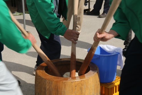
I retreated back out of the cloud like a dog with its tail between its legs. This fickle island weather was not making a good impression on this seasoned mountaineer. It was time for a change. Once back at the main road, I turned left and followed the automobiles and volunteer staff manning the intersections to the village office, where the local festival was reaching crescendo. Booths hawking local delicacies lined the interior of the multi-purpose hall, while a side room had island flora on display from some of the talented flower arrangers that call this isolated isle their home. Outside, men in green vests pounded mochi while another tent on the opposite side of the large open plaza served miso soup to a handful of elderly residents relaxing in the shade. I filled my belly with every free sample that I could get my hands on before eventually completing the exhausting walk back to the hostel.

hachijo2-6

The following day was my last on this island, and I proclaimed that there would be no more hiking. For one, I had climbed the only two mountains around, and two, I was in desperate need of a bath. The local bus circling the island provided motorized transport this time around, and I settled into an outdoor bath perched high on a plateau overlooking the mighty blue waters of the Pacific. Surely this must be the best bath among all of the Izu Islands, if not the Kanto region itself. It was an ample way to finish off my sojourn, with two mountains and two hot springs that left a favorable impression. Is Hachijō island the perfect weekend getaway for nature-starved Tokyoites? Perhaps, but Kansai residents may find better solace in seeking out the hidden coves of the Tango Peninsula in northern Kyoto.

hachijo2-7

Still, the short foray into those secluded islands of Tokyo whet my appetite for volcanic exploration. I vowed to make a return visit, next time to the sulfur-spewing flanks of Miyakejima as well as the tufted highlands of Kozushima.

Read Full Post »

In the southern part of the Izu island chain, approximately 300km from Tokyo, lies the idyllic island of Hachijō. Formed by tectonic uplift and volcanic activity, the gourd-shaped isle is home to excellent hiking and breathtaking hot springs, if the tourist literature is to be trusted. An in-depth investigation was necessary to determine the validity of such claims.

I set off from Takeshiba port on the Tachibana Maru, a high-speed, energy-efficient vessel that bears a striking resemblance to a Norwegian passenger liner. The color scheme, designed by renowned illustrator Ryohei Yanagihara, is apparently a tribute to the original Tachibana Maru ship that sailed these very waters in the Taisho era. The ship bobbed up and down in the turbulent sea like a rubber duckie in a hot tub, but the ferry eventually reached Sokodo port an hour behind schedule under strong gusts and menacing skies. After dropping off the kit at the nearby hostel, I set off on bicycle to explore the island. Thick cloud smothered the upper heights of Hachijo-fuji, so I simply needed to wait until a fair-weather window presented itself.

The guy manning the tourist-information counter recommended an electric bicycle and for good reason – the island is anything but flat and getting to the secluded hot springs on the southern tip of the island was an immense challenge without some kind of mechanical support. The ride was smooth enough, and after an hour of steady pedaling I reached the main cluster of hot spring baths at Nakanogō. My eyes were immediately drawn to a signpost pointing to Urami waterfall. I parked the bike and hit the trail into the jungle, following the narrow path as it crept deeper and deeper into the thick, vine-laced interior of the island. After twenty minutes of steady climbing the falls came into view. The water fell from a rock face about 10 meters above the jungle floor into a small pool stained brown with runoff from the higher reaches of the rain-sopped massif of Mt. Mihara. The path went directly behind the waterfall. I stood there some time admiring the spectacle of the wind sculpting the water into a twisted palette reminiscent of a typhoon-fueled rain squall. The hike was just the appetizer, however, and the main course awaited back at the parking lot.

hachijo1-3

A small narrow path just opposite the entrance to the falls led down to a small open shelter housing an exquisite open-air bath. Ever the bastion of modesty, the Tokyo-controlled island requires all visitors to wear a bathing suit into the mixed-bathing facility. Ill-prepared as I was, I bowed my head at a small shrine, asking for permission to use my boxer shorts in lieu of a proper suit and slowly eased into the steaming waters.

hachijo1-5

The first hot spring had lived up to its reputation, but how about the mountains? The next morning provided the answer. I awoke to clear skies and bright sun. Although the trailhead starts at the 8th stage point high on the flanks of the conical volcano, the only true way to appreciate the scale and immensity of the Fuji lookalike was to start from the beach, kitty-corner the hostel. I strapped on the day pack shortly after 9am and hit the trail, er I mean pavement of the main road leading inshore. The road from the ferry terminal led directly to the trailhead – all I needed to do was to follow the switchbacks and resist the urge to stick out my thumb. In search of lunch, I ducked my head into the first shōten I came across, shelling out 250 yen for a two-liter bottle of water. The convenience store, if you could call it that, only sold dried food, but the elderly woman behind the counter informed me of a larger supermarket just up the hill that sold onigiri. I marched up the road, eyeing the lines of the volcano as they converged towards the skyline that was starting to thicken with cloud. I picked up some yakisoba and a couple of rice balls at the store, wincing at the 88 yen signs affixed to the two-liter water bottles next to the checkout counter.

hachijo1-4

The road up to the trailhead meandered through the forests choked with tropical vegetation as steady streams of rental cars glided past. All I needed to do was stick out my thumb and any one of them would have come to my aid, but I was set on doing the entire mountain, road and all. It took about an hour to reach the start of the trail which, I found to my horror and disgust, was also made of concrete. The original trail consists of over 1200 steps made out of volcanic pumice, but a newer concrete channel snakes alongside the route, as if to beckon lazy hikers onto its slithering back. Is this what the suits in the government offices of Tokyo do with their extra budget money?

hachijo1-7

I pushed on in utter disappointment, but the state of the trail was the least of my concerns. A thick blanket of fog had engulfed the mountain, blotting out the views and my motivation to continue further on. I had reached the crater rim and was less than 50 vertical meters from the summit, but sat stooped on the volcanic pebbles cursing my ill-fated timing. If only I had hitched a ride earlier in the climb. The yakisoba helped lift the spirits as did the row of hikers dotted about the crater rim, drifting in an out of the cloud vapor. I pushed on, opting to head in a clockwise direction in an effort to get the buddhists on my side.

hachijo1-6

I reached the summit a short time later and raised the hands in triumph: it’s not everyday you can spend the morning on the beach and enjoy lunch on the top of an 850-meter high volcano. The crater rim was beautifully sculpted, both by the eruptions throughout the centuries and by the strong storms that often batter the summit highlands. The path consisted of ankle-deep mud in places and waist-deep bush in others. Every now and again the mist would start to break up only to be replaced by another layer of cloud. I reached a small clearing which apparently offers wonderful vistas, and a voice deep inside of me ushered me to pause. I surveyed the crater rim and spotted a group of four hikers heading counter-clockwise in the direction of my vicinity. As they crept closer, their fuzzy silhouettes came into focus. At the same time, a small pointy island floating offshore also came into view. By the time the quartet had arrived the cloud veil had miraculously lifted.

hachijo1-8

I peered down into the crater, the sheer drops forcing me to take a few steps back. It was frightening to think about how close I may have come to sinking into that void with such poor visibility earlier. There was a sheer drop of around a hundred vertical meters into what I now recognized as a double-crater. Hachijō-fuji had graced me with her awesome presence and I was star-struck and enamored with her searing beauty. When I completed the circumnavigation of the volcano the sun had made a much-welcome appearance, transforming the ash gray waters of the Pacific into an aquamarine paradise. A pair of hikers sipped on hot coffee at the junction back to the trailhead. I chatted with them a while before ducking down a path that led directly into the crater floor. A shrine was set up in the center, lined with smooth rocks that looked like they were picked from a riverbed. Messages were inscribed on the stones in a variety of styles and colors, the meanings of which I could not perceive.

hachijo1-9

I did eventually make my way back to the junction and down to the parking lot, where the latte-drinking couple from earlier were resting in the warm sunshine. They offered me a ride down to town and, in homage to Yuichiro Miura, I took them up on the offer and was soon back at the supermarket where I had purchased my provisions earlier in the day. I stumbled back to the port and collapsed in my bed, hatching up another insane climbing plan for the following morning.


Read Full Post »

Shortly after finishing the Hyakumeizan, I had a photo exhibition at a local cafe to display a few photos from my long conquest. During one quiet night of the one-month show, a young man in a baseball cap sat at the bar in quiet repose, staring at a half-finished beer as if in deep contemplation about an unfinished task at hand. He introduced himself as Willie, in a friendly, accommodation pattern of speech that could only come from Down Under. “I’m on number 99 myself,” pronounced my new companion, now drawn away from the tepid beer and deep into tales about the hundred mountains. He was about to become the first Australian to complete the Hyakumeizan, and fitting that I should meet his acquaintance with only one remaining mountain, as that is preciously the same situation in which I met the original Hyakumeizan conqueror Craig Mclachlan. During the course of our conversation, we both agreed on meeting up again somewhere in the hills of Kansai for a proper hike. Well, life became busy with menial tasks, and opportunities to meet up slipped away like a piece of raw squid through the chopsticks of life, but finally things were beginning to come together for a long overdue hike. And there would be no better place for such a rendezvous than the venerated peak of Wakasa-Fuji.

aoba1

Willie, who more commonly goes by the nickname of Will nowadays, picked me up at Yamashina station in Kyoto on a brisk yet bright Sunday morning in late March. His splendid wife Mai sat in the driver’s seat, slowly pointing the vehicle up the roads that would lead us deep past the heart of Kyoto Prefecture into the tip of the province. I shared the backseat with a young, reserved boy who looked more keen on a morning nap than a walk among the flowers. His name was Sota, and, like most kids his age, would eventually warm up to this new visitor encroaching on his backseat territory.

aoba2

The drive north took several hours, long enough for Will and I to discuss the topic that both of us know so much about. It’s not everyday that you can peak-drop and get a response, as the average citizen has never even heard of Uonuma-komagatake much less climbed it, but we were right at home sharing our stories like two reunited sailors who had spend their lives at sea. It was late morning by the time we parked the car at Matsunoodera, the start of the steep hike up Fuji’s precipitous flank. Plum flowers glowed in the strong light of the sun, bringing a touch of color to an otherwise monochromatic forest. A gentle breeze brought a wintry chill to the air that had us reaching for some insulating layers. Perhaps it would be a few more weeks before mother winter released her grip on northern Kinki.

aoba3

The trail started directly behind the double-pitched main hall of Matsunoo temple, an ancient worshipping ground of the Shingon sect of esoteric Buddhism. The towering cliffs of Mt. Aoba were, in ancient times, rife with monks in search of spiritual enlightenment, but nowadays you’ll be hard pressed to find anyone other than a mountaineer or mushroom hunter on the steeper pitches of the massif. We entered the forest and immediately started a short climb to the base of the mountain, marked by a stone torii that was apparently toppled by an intense wind storm. The pitch soon increased in intensity, which left us with little choice other than to grab every tree root, twig, and fixed rope that was placed to aid in the ascent. Beech trees rose in unison with a thinning cedar forest. Claw marks on some of the trees were a reminder that the black bear sometimes traverse even this far north in search of nourishment.

After roughly an hour of steady climbing the first of Aoba’s twin summits was reached, marked by no small surprise with a shrine. A gargantuan boulder sat perched behind the worship hall, accessible by means of a rickety ladder and an even ricketier set of chains. Will and I scaled up the rock with ease, but little Sota had to be coaxed up the slab with promises of a post-hike ice cream. The vistas down to hidden coves in the sea directly below were mesmerizing to say the least.

aoba6

From here, the ridge undulated through a series of igneous rock uplifted by tectonic forces centuries earlier, a reminder that Mt. Aoba wasn’t always the calm, dormant figure it pretends to be. Patches of snow lay hidden on shaded bits of bamboo grass as the path traversed around a gnarly cliff edge before popping out on the eastern, and higher, peak. It was here that we took a lunch break. Will, Sota, and Mai feasted on homemade bentos while I subsisted on a sandwich or two.

aoba5

After admiring the scenery, we dropped off the eastern flank of the volcano, through an area of rich deciduous forest and onto yet another cliff of congealed pumice. Sota clang closely to his mother as Will zeroed in on a photo of the duo crouched next to the edge of a long drop. Hopefully Sota will eventually learn to overcome his fear of heights before finishing primary school.

aoba9

On the descent, I had a chance to ask Will a little about some of the entertaining anecdotes on his blog that often leave me in cackles. I’ve had my fair share of good-humored encounters but can never quite pen them in such a creative way as our author does on his blog. His encounters in Hokkaido are particularly laden with witty, flowery descriptions. Hopefully the full tales of his Hyakumeizan adventures will eventually see themselves in printed form and if they do, I’ll be one of the first in line.

aoba7

The path eventually dissipated in a vegetable garden at the back of a decrepit house teetering on the brink of collapse. We had hit a paved road and weren’t exactly sure which way to go other than west. After meandering the back streets though a maze of traditional houses, we eventually found a forest road that would bring us back to the car. Nature was calling for Will, so he sped ahead in search of a clean depository while Mai, Sota and I trudged slowly behind. Fatigue was setting in for the little one, so we took turns kicking a rock down the deserted road in a effort to distract him from his woes. Once back at the car, we headed to the shores of Tsuruga bay to capture the most picturesque and most Fuji-esque of Aoba’s beautiful faces.

aoba8

With peak #57 now safely summited, I had only three more mountains to knock off this spring before the onset of the rainy season. Perhaps it was time to turn my attention to some other areas of Kansai that I had yet to explore.

Read Full Post »

Some people shy away from the mountains when the weather is anything less than immaculate. This is hardly an option, however, when you’re peak hunting in the secluded mountains of Kansai. Cloud marks dominated the weather forecast all day, but droplets had formed on the windows of the express train before it had even reached Wakayama city. I was en route to Kii-tanabe station for a long-awaited rendezvous with an obscure peak on the western edge of the Ootō mountains.

Ayako and Dewi were waiting upon my arrival, and we soon pointed the car to the north, following the Nakahechi route of the Kumano Kodo for part of the way before ducking deeper into the mountains via route 371. Plum blossoms in full bloom provided dashes of color among the gray cloud as the rain held the cedar pollen at bay. After passing the maiden’s hot spring, the route followed a moss-laden stream through bear valley until leaving the watershed and climbing by way of steep switchbacks high up the valley towards Hansa pass. The forest road passed by a water source signposted at the maiden’s tears, the second such reference to the otome (乙女) in this region. There must be some kind of legend associated with our target peak, but with no villagers around to ask, we’d have to leave it up to the imagination for the time being.

hansa3

Rain continued to fall in steady sheets upon reaching the trailhead. We all sorted through our kit in search of rain gear and other thermal wear that would keep up both dry and warm in the chilly March air. The forest canopy blocked most of the falling moisture as the trail meandered through the north facing slopes dotted with gigantic boulders caked in a verdant coating of mushy moss.

hansa5

The cedar plantations gave way to natural vegetation upon reaching the ridge of the long Ootō range. Turn left here and there were two more unclimbed peaks on the dwindling Kansai 100 list, a mere 16 hours away on foot. The task at hand was fortunately much closer as we turned right towards the summit of Hansamine, my 92nd peak. The locals prefer the Chinese reading of the last character and call this summit Hansarei. Despite the naming discrepancies, the jagged ridge of the massif earned our respect. It was easy to see why this mountain made the final cut on the Kansai 100 list.

hansa4

The route scaled up, in, and around some very impressive cliff formations that afford spectacular vistas in fair-weather conditions. The fog kept us focused at the task at hand, which mainly consisted of keeping our balance as the rain and gravity threatened to throw us off these lofty pinnacles. It took close to an hour to reach the high point, where a couple of brief summit photos were snapped before the three of us retreated back to the sheltered protection of the forest. This was one peak where taking a break was not an option.

hansa7

The return trip wasn’t as exciting as the climb. For one, the rain had picked up pace, leaving our gear thoroughly drenched. Drenched clothing brought on the chill: we had to keep moving to stay warm, but the spirits weren’t dampened. The mind stayed focused on some of the hairier bits of the traverse, with ropes in place to slow the downward momentum. Eventually the ridge flattened out once again and the conversation could be a bit more relaxed, once again focusing on the remaining peaks at hand. Dewi was on her 43rd peak, and fortunately we still had a couple of mutual peaks between us that remained unclimbed.

hansa6

Back at the car, we stripped off the wet gear and blasted the heat, chewing on our rations as Ayako drove towards Hyakken gorge. The road leading into the gorge was closed due to landslide damage from the notorious typhoon of 2011 that ravaged this entire area. Despite the massive amount of money Wakayama Prefecture spends on public works projects, this repair work falls by the wayside as government funding for new projects takes precedent over repair or upgrade to existing infrastructure. There was another way into the gorge, but it involved a 30-minute detour to the southeast. That route would actually take up directly past the trailhead to Mt. Houshi, a peak that was still left on the list. Since it was already past 2pm and the rain continued to fall, the hot spring baths of Shirahama won out over another soggy ascent.

hansa1

It was only upon my return to Osaka that I found out about the origin of the maiden reference. To the north of Hansarei, along a section of route 371 that we had driven through earlier, lies a vantage point of the mountain. From here, the entire ridge looks like the profile of a sleeping maiden: the contours of Hansarei itself form the facial profile, while the rest of the ridge stretching out to Mt. Mitsumori represent the torso. Apparently this profile can also be seen along parts of the Kumano Kodo, leaving the mountain with the peculiar nickname of the sleeping maiden.

Read Full Post »

At the tip of Lake Biwa there sits a circular body of water by the name of Lake Yogo. It is completely framed in on three sides by peaks of a small but by no means unimportant stature. The southern shores of the pond rise sharply to the historically significant Mt. Shizu, which affords views of both Yogo and Biwa, as well as an array of peaks rising off towards the northeast. It was on a winter excursion to this summit several winters ago that I spied a collection of snow-capped beauties serving as the boundary between the Kansai and Hokuriku regions. One of these snow bluffs is known as the Mt. Nanazu, the peak of the seven heads. The adjacent mountain, Mt. Yokoyama, is also on the list of Kansai Hyakumeizan, but it requires a monumental effort to climb if relying on public transport. Nanazu rises to the modest height of 693 meters, and the bus connections from Kinomoto make it an alluring destination for another March outing. It’s  just one week after the test hike of Mt. Yura, and with both the air pressure high and the pollen counts low, I set my sights on checking another mountain off the list before the true arrival of spring.

nana1

Although Kinomoto station sits on the eastern shores of Lake Biwa just a handful of stops north of the notable town of Nagahama, getting there in time for the 9:31am bus proved to be a big challenge. Fortunately, the Shinkansen runs up to Maibara station, which is only a 25-minutes by local train to Kinomoto. Though more costly, taking the fast train meant that I could lie in bed an extra hour. The bus to the trailhead was completely empty except for a father-and-son duo who got off at Sakaguchi to visit the mountainside shrine of Omi Tenmangu. I stayed on for about 10 more minutes until the knobby features of Mt. Nanatsu came into view. My eyes were immediately drawn to the outline of the peak converging to a knobby knuckle towering directly above. Perhaps this mountain would not give in so easily.

The initial part of the approach was by way of a gravel forest road that dead-ended at a bend in the swollen river. A small signpost indicated that the way to the summit lie just ahead, so I followed the well-worn path as it switchbacked towards the ridge. The trail wasted no time in gaining altitude, and soon the views not only opened up to the village below, but out to the Makino mountains lying due west. To my right, along a parallel ridge, the towering massif of Yokoyama dominated the entire eastern side of the horizon, fresh snow swirling from its lofty perch in a brave-hearted imitation of Sagarmāthā.

nana8

The forest here was mostly natural, with a few cedar trees thrown in to remind us that civilization lay not far away. Once the ridge was reached, the first remnants of winter became clear, as the trail disappeared under a long patch of wet, slushy snow. The snow was initially just a series of small tufts but eventually became deeper and more pronounced slightly below the summit. Beech trees swayed gently in the spring winds, patiently awaiting for the warmer temperatures that would catalyze the growth of their summer clothes.

nana2

I reached the summit shortly before noon and found a pair of shrines whose roofs were lightly dusted with free snowfall that had come the previous evening. Perhaps spring was not quite ready to make an appearance in these secluded heights of northern Shiga.

nana4

My map indicated a small pond just a short five-minute detour from the summit, but the deep drifts of snow made the footing precarious without crampons. I gave up, retreating back to the hut when nature decided to call. I always carry an emergency supply of toilet paper for just these kinds of situations and, when foraging around the inside of the shrine, I came across a shovel that also came in handy. It was as if Inspector Gadget had made an earlier ascent with me in mind.

nana7

After loitering in the warm sunshine, I gave up attempting a descend down the northern face because the trail was still frozen and there was absolutely no trace. There was no use in repeating the mistakes from Jyatani, so I simply retraced my steps back down to the river and sat by the swift-flowing waters fueled by fresh snowmelt.

nana5

My 56th meizan was now crossed off the list, and with plans for Aoba in the works, I knew that reaching the magic #60 wouldn’t take too long.

nana6

Read Full Post »

Frostnip can be a real blow to the psyche. Although the scrapes and bruises from my winter accident have fully healed, the tips of all 10 fingers are still on the mend, making even menial tasks a bit taxing. I needed an emotional boost, and the only remedy was to get back up on that horse and start climbing mountains again. A journey to the far north was in order.

yura1

The Yura river starts off deep in the mountains of northern Kyoto, in the ancient groves of the Ashyu forest managed by Kyoto University. Over the next hundred and fifty kilometers or so, it passes by villages stuck in an Edo-era time warp while meandering north, eventually dumping its emerald cache of pristine waters into Kunda Bay in the Sea of Japan. Near the mouth of this river sits the twin-peaked beauty of Mt. Yura, my target for this balmy March morning.

yura2

In an effort to save a bit of money, I opted for the highway bus to Maizuru city which was just a few train stations east of Tango-yura, the starting point for the long climb up the northern face of the mountain. The bus soon became a victim of the morning rush hour traffic in the city of Takarazuka, arriving in the port city of Maizuru far to the north nearly 45 minutes behind schedule. Fortunately, there was a train leaving in just a few minutes, so I ran up the escalator and onto the platform just before the doors closed. Trains are few and far between on the Tango railway: locals usually keep copies of the train timetable in their pockets in order to avoid the lengthy wait times between trains. The train pulled into Tango-yura station shortly after 11am under crystal clear skies and a relatively low pollen count that usually keeps me sidelined during the spring.  Mt. Yura dominated the skyline to the south and rightfully so: though only 640 meters in height, it rises straight from the sea just a few meters from the train platform. Looks like I had my work cut out for me.

yura3

The first fifteen minutes were along a narrow paved roadway that terminated at Yura-sō, a beautiful lodge affording wonderful sea vistas and mouth-watering crab during the colder winter months. Tempting as it was to stay the night, the day mission meant that loitering was kept to a minimum, and directly behind the lodge a small wooden kiosk marked the entrance to the mountain path. In this information booth there was a notebook filled with messages from other visitors, as well as a wonderfully composed hiking certificate on A5 cardstock that was free for the taking. I put one in my guidebook as a keepsake, knowing I’d likely be pressed for time on the descent in order to make the next available train.

The path immediately entered a severely eroded gully with chest-high ruts that made for an unexpected workout. The steep contours meant that the woods were free from the grasp of the forestry authorities who have a penchant for destroying the ecosystem by planting cedar trees. The first couple of stage points were checked off in no time at all, but, like most other dormant volcanoes, the mountain angle grows in direct proportion with elevation gained. It was in these thirty degrees slopes about halfway up the mountain that the cedar trees made an appearance, blotting out the light and transforming the forest into a standing army of long-legged evergreen soldiers ready for battle. Their main weapon came in the form of a thin yellow powder that would be released from the needles at the slightest touch of a breeze. This powder causes a severe allergic reaction to those unlucky hikers whose immune systems have been sensitized to the usually benign substance. I reached into my pack, pulling out my pollen mask as a shield against the aerial assault.

yura5

Fortunately the cedar army was a small one, and further up the peak the deciduous paradise returned, revealing swaths of unmelted snow that hung firmly to the harsh contours just below the summit ridge. Crampons were not necessary in the mild March sun, but kick-stepping added an additional level of security as the saddle between the peaks was finally breached. The western peak (西峰) was the higher of the two, so I turned right and followed the gentle curves of the bamboo grass-lined ridge through a grove of beech and oak still naked of leaf after the long, harsh winter. The vistas opened up towards the north of the summit, revealing the long sandspit of Amanohashidate that attracts hoards of tourists throughout the year. I was getting my own bird’s eye view, but without the chaos of the crowds.

yura6

I retreated back to the junction and onto the east peak (東峰), where the panoramic views really opened up. I crafted a seat out of a bundle of dried bamboo grass and soaked up the scenery. To my left, the sea extended uninterrupted out to the horizon. Turning clockwise, the mouth of the Yura river cut a line in the earth directly below, as a twin-peaked cone jutted out of Wakasa Bay like a miniature version of Mt. Fuji herself. In fact, the local nickname for this mountain is Wakasa-fuji, but most people know her by the name of Mt. Aoba, a peak that was still remaining on the list. Behind Aoba, you could just barely make out the snow-capped peaks of the Japan Alps spread across the hazy horizon like a chain of paper snowflakes hung in a kitchen window. Weather this fine is a rarity along the Sea of Japan coast, and if not for that afternoon train I could have easily lazed here until the dawn glow of the following morning.

yura7

As it was, I had planned to catch the 4:29pm train, so time was of the essence. Retracing my steps was simple enough, as I covered the knee-knocking slopes in a fraction of the time it took to ascend. Back on the train, the full effect of my exposure to the pollen let itself be known, with waterfalls of clear snot dripping freely from my poker-red nose. I popped an antihistamine and drifted off in a dazed sleep for the train journey back to Osaka.

yura9

Summiting Mt. Yura, mountain #55, was the confidence boost that I needed. The fingers held up surprisingly well and if I keep my hands covered with soft, thin gloves they don’t cause too much trouble. Pollen, on the other hand, was my real nemesis, but with the momentum on my side, a couple of more mountains in the mighty north had my name on them.

yura8

Read Full Post »