Feeds:
Posts
Comments

Archive for September, 2015

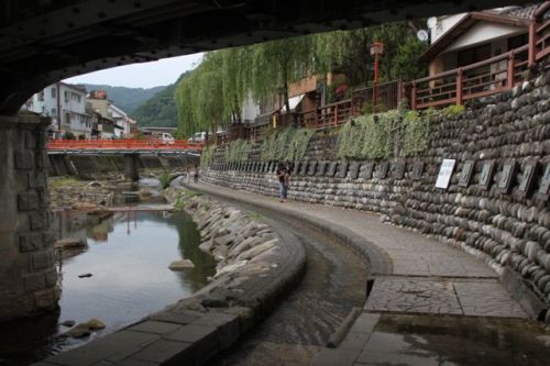
I have a self-imposed cutoff day of July 1st, where I go into hiding until the first cool winds of autumn push out the oppressive summer heat. Yes, June can be unbearably hot and humid, but depending on the rain, it can also offer a few pleasant days with relatively low humidity. Relatively.

nagusa1

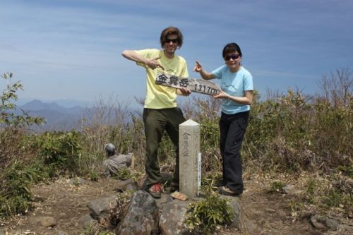
A clear weather day presented itself, and on a weekend no less. Paul M. was itching to get out, and I was itching to put another notch into my Kansai Hyakumeizan bedpost, so off we went to the hills of northern Hyogo for an assault on my 63rd mountain.

nagusa3

Mt. Nagusa. The mountain of 7 Seeds if the kanji are to be trusted. 683 meters high. Hardly a stalwart among mountains but one should not judge on size alone. Look at Mt. Aoba, just 10 meters higher. One slip on that monster and you can kiss your ankles goodbye.

nagusa2

We headed north on the JR Bantan line to Fukuzaki, where our only option to the trailhead was a 15-minute taxi ride. Our driver willfully abliged, handing us his business card upon exiting the cab at the deserted trailhead. The first part of the path was along a quiet forest road, shaded from the sweltering heat of the sun by a row of neatly crafted cedar trees. My GPS had a hard time picking up satellite reception, so for the time being I left it dangling below my shoulder strap until climbing higher above the constricted valley.

nagusa8

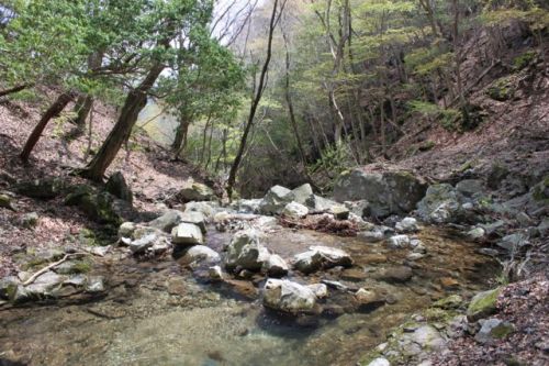
After half an hour we reached a large wooden gate marking the entrance to the ruins of Sakumonji. A grand temple complex once stood on the slopes of this very mountain, the waterfall of Nagusa providing the perfect setting to esoteric Buddhist training. The temple was torn down sometime during the oppressive Meiji era regime, replaced by a nondescript shrine overlooking the scenic falls. We left the road and entered the forest just beyond this symbolic gate for the 1km horizontal tramp to the waterfall.

nagusa4

At the falls I finally connected to a satellite and mapped out the course. The real climb began here, just to the left of the shrine via a constricted trail built without regard the the natural contours of the land. Steep was an understatement as the course made a beeline towards the summit. Views opened up intermittently to the tranquil and lush valley below, while above us the humidity threatened to squeeze the very life out of us, or at least the last of our sweat reserves.

nagusa5

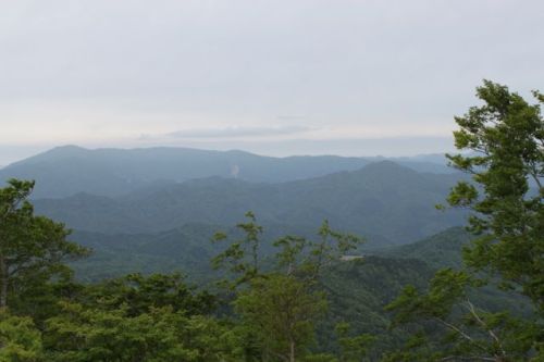
After an hour we topped out and were rewarded with splendid views northward to Mt. Seppiko. Due to temperatures in the mid-30s, the only logical alternative was to retrace our steps back to the start of the hike. Heat and humidity will do wonders to logic, however, and somehow we talked ourselves into completing a more challenging loop hike via a pointy prominence called Nagusa-yari, named after its more famous older father in the Japan Alps. The trail lost altitude via a series of chains and fortunately entered a thick forest that blocked out the sunlight. The woods also cut us off from the cool breeze wafting through the exposed summit, so our pace slowed to a crawl as we continually cleared the sweat from our heavy brows.

nagusa6

It was a long, truly dreadful 3km climb to the spear-like crown of the summit, which only offered partial views off the less wooded eastern side. From the top, the trail once again dropped to a saddle, following the outline of the rocky knife-edge ridge with steep drops on either side. Nestled directly on this narrow spine we came across a Japanese hornet sitting directly in the middle of the trail. I took a slow step forward, but the hornet raised its eyebrows in anger, threatening to launch an offensive. Not wanting to risk a potentially lethal sting, I shuffled down the leeward side of the ridge, tiptoeing on an exposed rock outcrop while grabbing tree branches to assist in keeping me vertical. Once past the bee I climbed back up to the ridge and met up with Paul, who had simply leapt over the menacing insect, likely pissing it off in the process. I knew if two of us crossed its path one of us was likely to fall victim to its venomous prick.

nagusa7

Out of the danger zone, we traversed over a few smaller peaks with no shade to shelter us from the intense sun beams. Shuffling forward, the shores of Nagusa pond eventually came into view, the trail dropping via a series of meandering switchbacks until reaching the shore. On the far end of the waters sat a day-use hut, which we reached a short time later. The cool comforts of the air conditioner was most welcome. I stripped off my boots and socks and placed them on the entrance steps to air out in the direct sun while we waited for the taxi to pick us up again. We both polished off a liter of Aquarius while attempting to pull our bodies from the brink of dehydration. Despite the immense beauty, perhaps it wasn’t the wisest of times to explore the peak during the height of the sweat season, but the ascent did bring me one step closer to reaching my goal.

Read Full Post »

Just One More

Despite the thick cloud and misty rain, mountain #99 was knocked off in a sloppy, sweaty affair. If anyone else is attempting the Kansai Hyakumeizan, I don’t recommend saving the 15 toughest hikes until the end. This one looked easy on the map but it nearly did me in. Luckily there are no more mountains in the Ōmine mountains left to climb.

IMG_5092

Apparently the last one is a piece of cake, if the forest road to the trailhead is open, that is. If not, then it could turn out to be the toughest of them all.

Read Full Post »

Nestled on the prefectural border of Hyogo and Tottori, and a bit further north of Hyogo’s highest peak Hyōnosen, lies the graceful, ladylike curves of Ōginosen. What the mountain lacks in height it more than makes up for in subtle beauty, according to reports from other Japanese hikers, that is. With so few foreign climbers venturing that far north into the deepest reaches of the Kinki region, it was time for an investigative look.

oogi7

Simon, Ritsuko, Kanako and I cruised north along route 9 through dinosaur country, at least that’s what it used to be millions of years ago when the fearless creatures roamed the earth. Nowadays the area is teeming with dinosaur statues, thanks to the discovery of fossils in the area and an even more recent uncovering of fossilized theropod eggs. From the look of things, you’d think that Hyogo Prefecture was the dinosaur capital of Japan, but that distinction goes to Katsuyama in Fukui prefecture.

oogi3

We based ourselves at Yumura onsen, a hot spring town whose popularity peaked in the 1980s as the location for the popular television drama Yumechiyo-nikki. During that time, the town was bustling with tourists flocking here to get a taste of rural life, but now the concrete hotels and souvenir shops lay abandoned, the victim of the bursting bubble and nearby Kinosaki onsen, which is now the ‘go to’ place for hot spring enthusiasts. Still, the town provided the closest base camp for our target peak the following morning, and a hot spring bath is a hot spring bath, no matter what the rest of the town may fail to offer.

oogi1

The next day, after a modest breakfast at the inn, Simon navigated our vehicle up a narrow, hard surfaced forest road that weaved in and out of cedar plantations, skirted the edge of an abandoned dairy farm, and finally crossed a thick yellow line painted across the road that marked the prefectural border. We parked the car in front of an artificial pond and geared up for the easy stroll to the summit. With only 200 vertical meters of elevation gain spread out over 3km, we knew we were in for an easy day.

oogi2

The trail immediately ducked into an enormous virgin Siebold beech forest, perhaps the finest of its kind in the entire Kansai area. The path was completely flat for the first kilometer of the pleasant stroll, as our eyes were constantly drawn upwards to the verdant greenery of the foliage set against the muted overcast sky above. From the lush canopy the spotted gray trunks of the towering trees pierced the forest floor like telephone poles lined along a city street.

oogi5

Soon Simon and I split up from the ladies, opting to get a little cardiovascular workout as we approached the first rise in the contours. We coasted to the crest of the first hill, but had to ease back the pace a little as my heart went into palpitations. Ever since my surgery the doctors had warned me not to get the BPMs up to dance music level for fear of overworking the mechanical valve, so I took a rest until my pulse dropped back down to under 100.

oogi4

After this first climb, the path dropped gradually to a long saddle through more thickets of beech and other hardwoods before climbing the crest of the ridge over a gentle rise to the high point, which was dominated by a wooden emergency hut in immaculate shape. The builders had taken great pains to build the rustic structure directly on the high point, even going so far as to include a ladder to the second floor for mid-winter access. Indeed, it seems that snowshoeing is a popular activity in the colder, frostier months, and the soft gradient helps keep the avalanches at bay. We checked out the views northward to Hyōnosen while waiting for Kanako to Ritsuko to catch up. Once reunited, the summit was invaded by a group of 50 walkers that were part of a guided tour. They snatched up every available inch of soil space while we beat a hasty retreat back to the car.

oogi6

In a village at the foot of the mountain we paused for a bowl of udon noodles and chatted with the vivacious elderly women working the kitchen. The owner, a man in his early 80s, showed off a picture of an asiatic black bear he had taken while walking in the beech forests in early spring. Apparently the nuts and acorns make it a prime habitat for the ursine creatures, and they sometimes venture a little too far into the village in search of extra nourishment. Our host explained: “Last autumn a bear wandered into a trap set up for wild boar and became stuck. We called the animal rescue office, who tranquilized the animal and transported it back into the forests far away from here.”

oogi8

With the mountain safely behind us, we took the slow road back to Osaka, stopping at Takeda castle for a short side trip. Dubbed the “Machu Picchu ” of Japan, the castle ruins sit perched on a mountain plateau high above the valley below. To compare it to the lofty Inca settlement is a bit of a stretch, but there’s nothing that the locals won’t do to attract the tourist dollar.


Read Full Post »

And then there were two

The finish line to the Kansai 100 is now in sight, and the race against the winter snows is now on. IMG_4480


Read Full Post »

The mountains of southern Wakayama are daunting, not only for their steep contours, but also for the challenging access by public transport. Hence my current predicament: the bus arrives at the trailhead at 1:35pm, departing for Koza station at 3:32pm. The map says to allow 2 hours and 35 minutes to complete the loop up and over the twin crags sitting on the summit of Dakenomori. I’d need to shave half an hour off the climb in order to make the last bus back to the station. It was just another mountain on the list where I would be very pressed for time.

dake2

The sun hung high over the mountain as I alighted the bus. Directly across the river from the bus stop sat an immense rock formation called Ichimai-iwa, Japan’s answer to Ayers rock if the tourist literature is to be trusted. I headed north on route 371, reaching the trailhead just before a tunnel in the road. The path immediately gained altitude, marked by a series of signs warning hikers to beware of bees. Apparently, the mountain is a habitat for the menacing giant hornet, whose powerful stings cause roughly two dozen deaths per year. Being early April, I knew the bees, if awake at all, would be woozy from their winter hibernation and hardly a threat. Still, I kept a vigilant eye for any airborne creatures.

dake1

The path rose above the tunnel, reaching a humongous slab of granite through which the trail ran directly through. Footwork was tricky on the rock face made slick by recent rains. Ruts in the slab indicated safe places for hikers to put their soles, and ropes in the steeper sections help aid the ascent as well. Just past this rock formation, the trail dove into a cedar forest before reaching the ridge line. From here, it was an incredibly steep climb to the upper reaches of the mountain, where even the cedar trees could not scale.

dake3

The first of Dakenomori’s twin summits was breached in only 45 minutes from the paved road below. I had cut the map time in half, but paid for it in sheer sweat and fatigue. I took a gulp from my sports drink while admiring the views from the lofty perch. Just to the north, the long flowing ridge of Mt. Otō came into view, followed by a handful of other mountains whose shape and name I could not discern. The route dropped to a saddle, followed by an even steeper, rope-lined ascent of the second peak. The views from here were not as impressive, but it would have been a waste to have skipped one of the peaks. I always make a concerted effort to climb both peaks if the mountain is indeed a twin – whether it be Mt. Shiomi in the Southern Alps, or Kashima-yari in the North, climbing both sets of twins offers a rare chance to look back on your target peak with envy, just as a jealous younger sister looks up to her older sibling.

dake5

Dropping back into the forest, the trail skirted along the edge of some more rock formations before looping back to the bus stop through yet another nondescript cedar plantation. I made it to the bus stop with plenty of time to spare before the last bus back to the station. The first of many Wakayama ‘toughies’ was now in the books. Tough not in the elevation gained, but in the kilometers traveled just to reach their forgotten depths.

dake4

Read Full Post »

Perhaps it wasn’t the wisest decision to head to the Suzuka mountains during the Golden week rush, but what other choice do you have when your target peak looks like this:

kama1

So I once again found myself on an early morning train, this time to eastern Mie Prefecture on the Kintetsu line. The fastest train took over 3 hours, so shortly before noon I boarded a taxi for the short journey to the foot of Mt. Gozaisho. The only problem was that hundreds of other hikers had exactly the same intention, and the cab ground to a halt well below the trailhead. I jumped out, opting to foot it the rest of the way, finally arriving at the entrance to the gondola that whisks lazy hikers to the summit of one of the most overdeveloped of the 200 famous mountains. Gondola, you say?

kama2

I usually turn up my nose to such modern contraptions, but my target this time around was not Gozaisho but the neighboring peak of Mt. Kama. A rugged ridge line connects the two mountains, so instead of wasting precious time ascending to the ridge, I thought it best to start directly on top. I had already climbed Gozaisho one time before from the base, so the peak was already checked off of the Kansai 100 list. The top of the gondola was teeming with tourists who were more intent on viewing the skunk cabbage in bloom than hoofing it up a mountain.

kama3

From the summit of Gozaisho, the route dropped abruptly, through an area of well-worn sandstone that gave the footwork a challenge. Chains embedded in the rock helped slow the gravitational pull, and after an hour I bottomed out at Buhei pass, pausing for a short time for mid-day sustenance. The route climbed just as abruptly on the far side of the pass, through an area of Akebono azalea in full bloom. The pink blossoms, which come to life before the foliage, contrasted starkly with the gray branches and the light blue sky above. The trail intensified in gradient through a maze of sandstone and towering boulders. Just below the final climb, ropes clung precariously to the crumbly walls of the sedimentary monolith, making for a hair-raising ascent. Two hours after setting off from the top of the gondola, I topped out on the tiny perch of a summit and collapsed against a weather-beaten boulder. The panoramic views were astounding, but I was focused more on staying hydrated and cool in the thick May air.

kama4

The route dropped dramatically on the far side of the pyramid, the sandstone giving way to hard, crystalline granite that made for a pleasant descent. The peak is a geological anomaly in the contrasting rockwork of the northern and southern faces, the likely result of fierce tectonic forces millions of years ago. At the bottom of the sharp drop I reached Dake pass, with a spur trail that dropped to the east and looped back towards the bottom of the gondola. The route was difficult to pick up as it traversed the side of a narrow gorge carved out by heavy rains and flowing streams. Paint marks on the boulders and tape marks affixed at regular intervals along the deciduous boulevard made things a bit easier, and shortly before 4pm I popped out on the main road and coasted down to the bus stop with only minutes to spare.

kama5

With Mt. Kama in the books, only two more peaks remained unscaled in the mighty Suzuka range. I’d have to wait until after leech season to seize an opportunity to visit again.


Read Full Post »

After a day of rest, I enlisted the company of Kanako for an ascent of what has to be the strangest name on the list: Kanakuso. The word literally translates as gold shit, an apt name considering the Golden Week holiday now in full swing. We arrived at Nagahama station on the eastern shores of Lake Biwa by mid-morning, negotiating with a taxi driver for the 40-minute drive to the trailhead. The driver had never been to the mountain before and grossly undercharged us for what should have been a 7000 yen ride. Taxi drivers in the countryside will quite often agree on a pre-determined price before their journey and simply shut off the meter when the negotiated fare is reached. Fortunately for us, the meter reached our agreed-upon price of 4000 yen before we even reached the start of the forest road.

kana5

Our driver negotiated the hairpin turns of the windy road like any seasoned driver, much to the chagrin of Kanako, whose soon lost color in her face. At the mountain pass, we stepped out of the cab and bid our driver a farewell, stuffing his business card into my back pocket to ensure a return ride off the mountain. Two steps into our hike and Kanako lost her breakfast all over the trail. To make matters worse, a quick confirmation on the GPS revealed that we weren’t even on the correct path: the route quickly vanished into a sea of overgrown bush. Kanako was not a happy hiker, but we pushed on through the bamboo grass, whose tufts still lay heavy with snowmelt. Several of these tricky snowfields needed to be traversed before we finally reached the real trailhead in a heap of sweat and fatigue. I gave Kanako some snacks to help ease the nausea.

kana1

The trail lost altitude quickly as it dropped to a mountain pass just below the saddle of the peak. Astoundingly, the forest road that we just left looped around and met up with this very saddle. All we needed to do was continue walking on the road down the Gifu side of the mountain and we would have reached the correct path. Gold shit indeed.

kana3

It took close to an hour for the no-nonsense climb up the spine of the mountain, but we popped out on the summit of mountain #60 just before noon on a bright yet hazy morning. The horizon was stained yellow with aeolian dust, reducing visibility to 10km at best. On a clear day, the summit affords some of the best views of the Hakusan and the Kita Alps from any mountain in Kansai. I thought about leaving my own gift of gold on the summit but my bowels would not cooperate.

kana4

After a brief rest, we headed back down the way we came, but this time opting to stay on the path. It would take us all the way back to Nagahama station if we allowed it, but after reaching the forest road we threw in the towel and called the cab. We simply walked down the forest road until the taxi caught up with us. Our driver handed us two cold bottles of Aquarius which were much appreciated in the stifling spring heat.

kana2

With two peaks down, one more mountain remained to round out the tryptic.

Read Full Post »

At the beginning of May every year, a cluster of holidays provide workers a brief respite known as  Golden Week. As such, scores of hikers head to the mountains to enjoy the usually pleasant weather every year. Avoiding such crowds can be tricky, unless you’re armed with a list of peaks so obscure that even seasoned mountaineers scratch their head upon hearing their names. Hence, the aptly-named Sengamine, a 1000-meter peak nestled deeply in the mountains of central Hyogo Prefecture.

sen3

Tomomi and I set off early along the JR Tokai line to Kakogawa station, where another train whisked us north through the Bantan plains northward to the Shisō region dominated by a string of 4-digit peaks stretching uninterrupted to Hyonosen, Hyogo’s highest point. At Nishiwaki station, we boarded a bus an hour further northward, alighting on a rural road at the base of the towering ridge. From there, it was another hour walk along a forest road to the trailhead. Luckily, the first car that passed gave us a ride to the start of the track, shaving off a couple of hundred vertical meters of ascent.

sen1

Soon after entering the forest, the path skirted the edge of multi-tiered Mitani waterfall, whose whitewater shoots flowed gracefully down the contours of the angled flank of the mountain. Huge swaths of planted cedar marred the beauty somewhat, a reminder to the great lengths the government has gone to ensure there’ll be no shortage of unwanted timber. The plantations extended high into the upper reaches of the sawa before finally yielding to a colony of deciduous trees basking in the May sunshine.

sen2

The angled eased at the ridge, where a trail led off to the left to Zenkōji temple at the southern foot of the mountain. From here, it was a stroll on the undulating spine of the range before a final scramble just below the summit plateau. Tomomi and I topped out shortly before noon and grabbed a bench on the wind-swept summit. A couple of small hiking groups occupied the far corner of the broad, open top as we studied the map for an alternative way off the mountain. A bit further along the ridge to the north there is a trail that descends a valley parallel to the one we ascended, so after fueling up we once again made forward progress.

sen4

After half an hour, the route lost altitude quickly, running headlong into a paved forest road with a couple of parked cars holding fort. From here the trail continued through a cedar forest, but was hard to pick up amongst the toppled trees and thick underbrush. The path eventually connected with the forest road again, where our stroll turned into a trot upon the sudden realization that we may not make the final bus back to the station. What the map indicated would take 40 minutes we covered in just 10, arriving with mere seconds to spare before collapsing in a heap of sweat and labored breaths.

sen5

Another peak in Hyogo could be safely checked off the list, and with the week just beginning, I was hoping to strike gold by knocking off a couple of other tough ones.

Read Full Post »