Feeds:
Posts
Comments

Archive for January, 2016

For some reason, Mt. Tsubone is referred to as the Yari-ga-take of Kansai, but it seems like a bit of a stretch, unless you find the right angle. On a frigid winter day, on the summit of mountain #50 to be exact, a spear-like mountain did catch my eye, causing me to consult my map and wonder if it, too, were on the list of venerable 100.

Image

The answer was in the affirmative, and so I set my sights for a clear weather climbing window in late summer. Time time around Paul M. and I were joined by Josh, a 40-something Californian snowboard and surfing hound turned part-time hiker. He picked us up at Yagi station in eastern Nara Prefecture and we scooted along route 166 under sunny skies and balmy temperatures. The rural route gained altitude via curving switchbacks to the base of Mt. Takami, where a long tunnel through the heart of the mountain spit us out into Mie Prefecture and into unexpected rains. It turns out that the Daiko mountains, for which Mt. Takami forms the northernmost edge, are a bit of microclimate, trapping in moisture throughout the year. We parked at the trailhead to our target peak, sorting through gear for things to help keep us dry.

IMG_8984

The mountain hung heavy in the sticky air, the clouds gripping tightly to the summit like a toddler clinging to its mothers’ warm bosom. After a bit of a false start up a paved forest road, we spotted the unmarked trailhead thanks to a pre-set GPS bearing and trudged up through a thicket of planted cedar and cypress. After only five minutes I stripped off the rain jacket and opted for just a short-sleeved t-shirt. Temperatures were in the low 30s and the rain was anything but refreshing.

IMG_9029

After half an hour up the trail we left the cedars behind and entered a deciduous oasis or moss-covered boulders and trickling streams that brought thoughts of the Omine mountains to mind. In our steady pace I had somehow attracted the attention of a pesky hornet, who continually pounced upon my backpack like it was some long-sworn enemy. After the fifth or sixth round I dropped my gear and stripped away my black rain cover, exposing the vibrant reddish-orange hues of the original pack fabric. The hornet shuffled off to play with something a bit more interesting while I continued on in a more relaxed pace. Apparently the bees are strongly attracted to the color black – lesson learned.

IMG_8952

The rain abated as we hit the summit ridge, but the fog did not loosen its tight grip, lending an ethereal air to the already surreal landscape. Josh was utterly fascinated by a spectacle I’ve long grow accustomed to over the years. I will admit though, that a pristine forest draped in cloud is a thousand times more pleasant that a slog through a carpet of waist-high creeping pine and weather-beaten rocks.

IMG_9042

Shortly after lunch the three of us popped out on the high point and immediately parked our wet, sweaty bodies on a wooden bench. Paul M. broke out the coffee cups while I chugged away at the sports drink. The top was marred by a microwave antenna jutting out on the northern face of the peak. As we sipped on our mountain mochas the clouds broke up, yielding brief glimpses of the Daiko mountains rising gallantly to the south. Josh moved closer to the microwave antenna for a better view but was immediately driven back by a swarm of bees who had nested themselves on the narrow summit plateau. Perhaps we should have saved this mountain for the cooler months when the insects are less sprightly.

IMG_9096

We retreated the way we had come, veering right at the first trail junction at the start of the ridge for a variation loop on the descent. This route yielded scenery no different from our climbing route, but it did offer us a chance to stretch our muscles by meandering through some long switchbacks carved into the cedar plantation. By the time we had reached the forest road the mountain was bathed in unexpected sunshine. Despite our untimely visit we still had an enjoyable time on Kansai’s very own Mt. Yari. It wasn’t as steep or daunting as its more prominent cousin in the Kita Alps, but it was still a worthy investment of our time. And with mountain #65 out of the way I could finally start counting down the remaining peaks instead of counting up, as I had reached the edge of the tipping point in my quest for the Kansai 100.

Read Full Post »

Another month passes, and with the door on 2015 quickly closing, I seize a final chance to finish the last section of the first third of the Diamond Trail before the start of the new year. Gear packed, bus schedule confirmed, and clear weather forecast. What could go wrong?

IMG_6732

I arrive at Tondabayashi station a little past 9am and search for the bus stop that will take me to Hiraishi. According to my on-line research, the bus leaves at 9:15am for the 20-minute uphill journey to the village that I had visited just 6 weeks prior. There are plenty of buses milling about, none of which will shuttle me where I need to go. At 9:13am, panic starts to set in, and I inquire with a bus attendant loitering about.

IMG_6729

“Oh, there’s no bus at 9:15am,” replies the uniformed official, clutching strongly to a laminated copy of the bus schedule in his white-gloved hands. “That bus left at 8:50am.” I give a look of bewildered disbelief, my heart sinking even further into my tightened abdomen upon receiving the following additional detail: “The next bus for Hiraishi leaves at 3:20pm.”

IMG_6736

Before I can even mutter a forced thank you from my mouth, I am already rushing over to the taxi stand, flagging down a ride with a stern driver who seems more interested in bringing on lung cancer through his unfiltered cigarette than saving a hiker from an agonizing 7km walk. Still, he puts out his butt and ushers me over for the silent ride to where I had left off on Halloween. Once at the bus stop, I switch on the GPS, pull out the trekking pole, and gaze up at the bus schedule affixed to a half-corroded metal pole: “9:15am departure for Tondabayashi station”. Of course! In my haste to find the bus schedule, I had found the bus schedule from Hiraishi to Tondabayashi instead of the other way around. The Kongō bus company really needs to hire a proper web designer who can create a user-friendly web navigation system.

IMG_6720

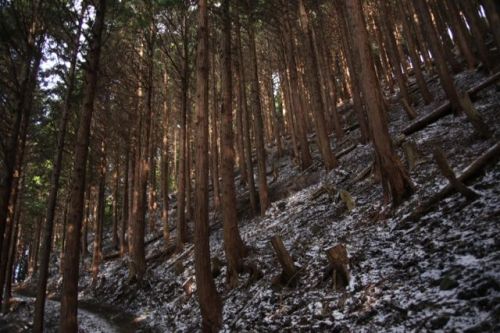
With my wallet quite a bit emptier, I march back up the road and follow the previous GPS track still recorded in my device. Patches of green weeds tinged with the first frosts of the season line both sides of the cracked concrete road as the sun filtered through a thick grove of cedar. Ahead of me, the whooshing sound of a spinning mechanism breaks the still air of the morning, and suddenly the burly form of a mountain biker swishes right past my frightened figure. He lets out a quick “sumimasen” without even slowing his breakneck pace.

IMG_6768

I reach the unmarked junction and leave the forest road, carving my way up the ruts in the overused path. After another mountain biker swooshes past, I find the cause of so much erosion. It looks like hikers aren’t the only ones to forge a path through this cedar labrinyth.

IMG_6772

Steady is the pace up the easy-to-follow route – the memory from October is still freshly burned in my prefrontal cortex, and I can simply use the electrical pylons as visual signs of progress. Just below the final push to the ridge line, the sound of bear bells descends swiftly towards me. I step aside as two more cyclists zoom past. At least these guys have the courtesy to warn me beforehand. If not for those bells I surely would have been turned into a pancake.

IMG_6755

It takes about an hour to reach the ridge line again, where I take a brief rest on that exact same bench where I had thrown in the towel back in the autumn. I feel completely different this time around, with still plenty of energy reserves left in my rejuvenated body. At taking a few deep breaths, I take the first few steps upwards, along that virtual stairway to heaven that had sent me retreating to Hiraishi. There are easily over 100 steps rising incessantly towards the summit of Mt. Iwahashi. It is there that I pen a new name for this godforsaken trail. It would be known as the Diamond Trail no longer. “Forget diamonds”, I mutter under my labored breathing, “this is the Kaidan trail”.

IMG_6788

At the top of the final rise, the incline gives way to a gently rolling summit plateau dotted with leaf-bearing tree cover. At the high point, two sweaty hikers occupy a bench on the far side of the broad opening. They had started at Nijō earlier in the day, and give me invaluable advice about what lies ahead of me. I thank them, marching down some more wooden log stairs along the shaded northern face of the mountain singing Lucy in the Sky with Kaidan.

IMG_6785

The next section along the route is an undulating wave of gentle descents followed by slight rises in the gradient. Occasionally the path would pop out into a clearing affording views down to Osaka city, but for the most part the route moves through suffocating cedar plantations.  I make good time as I push onwards towards Mt. Nijō.

IMG_6821

Just before reaching Takenouchi pass, the route merges with a concrete forest road, following it for about half a kilometer before dumping me out on route 166. A hand-drawn sign on the guardrail ushers me towards the left, where apparently the Kaidan trail continues onwards to Nijō. I manage to walk along route 166 for preciously 50 meters before being kidnapped and held hostage for well over an hour. Well, that’s not exactly what happened, as the hostage taking is entirely voluntary. You see, I fall victim to what I can only describe at the work of a purely evil genius, the kind that would create something so tempting and so inviting that only those with the strongest willpower can resist: a non-smoking organic cafe. I open the door of the Irodori Mint Cafe and am shown to a seat near the window by the courteous server. Being Christmas season, they have a special lunch that includes roast pork, quiche, and hearty minestrone, which sets me back 1300 yen but does include a drink and dessert. I peel off my warmer layers, basking in the heated comforts of the dining room while resting the muscles. The food really hits the spot, and the hot coffee puts the kick back into my step.

IMG_6931

Once back out on the pavement, I continue cruising downhill, reaching a broad parking lot and signpost for the Diamond Trail. I turn right here, following the stone path as it leads straight up towards the ridge line that I had left at the top of the pass. Things start to look vaguely familiar, and at the top of the hill I am once again back in familiar territory. I have once again reached Iwaya grotto, a place I had visited on Day 1 of my section hike. There is still work to be done, however, because I realize that the actual trail continues along the ridge towards Katsuragi instead of dropping towards Iwaya. By turning left at Route 166, I have accidentally skipped a small section of the real trail. Buzzing on caffeine and playing the role of purist, I turn away from Nijō and marcd along the route towards Katsuragi. It takes about 20 minutes to reconnect with route 166, where I realize my mistake. On the one hand, I did have the best mountain lunch in existence by erroneously making that left-hand turn. Future Diamond Trailers (if that is indeed what we can call hikers doing the Diamond Trail) should make note of this and consider stopping by the cafe for a bit to eat en route to their destination.

IMG_6881

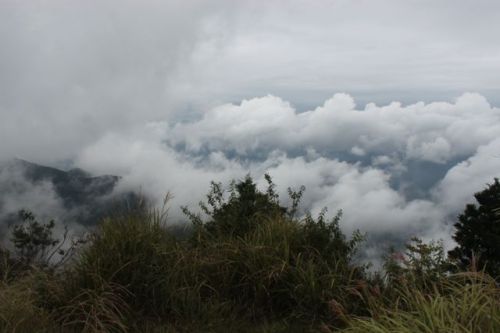
From route 166, I retrace my steps up the steep trail back to Iwaya, where I once again summit the female peak of Mt. Nijō. By now the temperature has risen to nearly 15 degrees, which is way too warm for my fleece-lined thermal pants. I strip down to my boxer shorts, laying my trousers inside-out in the sun in order to allow the sweat to evaporate. There is a giant sundial directly on the summit, and in the clear weather and strong sunshine, the time keeper is precise. It is 2:10pm when I arrive on the top, and this time around, the vistas do not disappoint.

IMG_6883

Laid out before me are the Ōmine mountains, shining brightly in the crystalline air with nary a glint from the light coating of snow clinging tightly to the upper reaches of Kansai’s highest mountain range. To the left of the lofty peaks, the smaller but just as impressive chain of the Daiko mountains stretch out across the azure horizon. These mountains too lay eerily free of the wintry white that usually sits thick in the wet December air. It is an unusually mild winter by Japanese standards, likely attributed to the strong El Nino dominating the waters of the Equatorial Pacific region.

Image

My gaze at the mesmerizing vistas is broken by a rowdy group of a dozen climbers who have just arrived on the summit. Remembering that I am still half-naked, I scramble to conceal myself and have just finished zipping up my fly when they invade the high point, lying just one meter behind my granite bench. They take turns snapping summit proofs of each other, until they start setting up a timer for a group shot. I offer to take their photo instead, which they gladly accept. As everyone gathers, one of the senior members of the group pulls out a small banner that had a rather intricate and stylized logo embroidered onto the fabric. It looks like an insignia that King Arthur might wear, were he alive today.

IMG_6907

“What is that?” I inquired, clearly puzzled and intrigued by such an intricate logo for such a small group of climbers. “JAC”, comes the reply, “Japan Alpine Club”. My jaw drops, for here are members of Japan’s legendary Sangaku Kai, a mountaineering organization that has connections to Walter Weston himself. We talk for several minutes, with more than a few members impressed with my mountaineering resume. It’s not everyday that Japanese hikers can chat with a foreigner who has not only climbed the Nihon Hyakumeizan, but also the Kansai Hyakumeizan as well. “You should join our club”, remarks the leader. I brush off the praise, not sure if the invitation is genuine or just a show of respect from someone who probably has a more impressive resume than yours truly. After all, this particular group is section hiking all of the prefectural borders from the Sea of Japan to the Pacific Ocean. They have statred in Fukui Prefecture and have followed the Fukui/Shiga border before turning southward and eventually linking up with the Osaka/Nara border which they will follow all the way down to Wakayama.

IMG_6909

After bidding farewell to the JAC, I drop off the summit to the north and turn left. My original plan is to descend into Nara, but a phone conversation with Ted during lunch has convinced me that the Rokutanji ruins on the Osaka side are well worth checking out. I have never descended down this side of Nijō before, and now seems as good a time as any. The path drops abruptly though a series of boulder fields before arriving at the temple ruins, which are dominated by a large stone pagoda dating from the 8th century. A grotto once housing Buddhist relics sits nearby, a metal gate firmly affixed to keep vandals from carving their initials into the sacred cave. From here, the path continues descending to the parking lot I had seen earlier in the day, so after a brief detour to a lookout point, I drop back down to route 166, which I consider following all the way back to the station.

IMG_6900

However, my map indicates a more interesting trail that continues a little further along the ridge, so back into the forest I duck, climbing a series of switchbacks before once again traversing the spine of the mountain. After a series of ups and downs, the trail once again loses altitude and ends at a paved road that runs directly under an expressway. I follow this road until it tosses me out on a larger paved road that apparently leads to the Takenouchi Kaido museum. Of course I end up taking a wrong turn, not realizing my mistake until I am a further 3km down the road, which passedsright by a racetrack for remote-controlled cars. Somehow, I manage to reach Kaminotaishi station just before dusk. All in all I have probably traversed well over 15km, but the first section of the Diamond Trail is in the books. The next section between Katsuragi and Kongō is now on the radar screen. Now, if I can only seize a chance to escape from nappy changing duties……

Diamond Trail – Section Hike part 4

Read Full Post »

The second section of the Diamond trail follows the undulating ridge between the peaks of Nijō and Katsuragi for a total distance of around 10km. From afar, the spine of the mountain looks like nothing more than a gentle rise, but I know I have my work cut out for me. After putting off this section for all of the summer, I open a small gap in my incredibly hectic schedule, forgoing the Halloween festivities in favor of knocking out this herculean chunk of ridge.

IMG_5924

Since I had already summited Katsuragi several times before, I opt for the comfort and luxury of the ropeway on the Nara side of the mountain. Getting there requires a change of trains at Shakudo, followed by a bus from Gose station. By the time I board the gondola it is already approaching 1pm. So much for the early start.

IMG_5931

From the top of the lift, I bolt up the wide path like a steed out of the starting gate. The autumn foliage is at its peak, and what little deciduous cover remains on the blighted peak glows brilliantly in the mid-autumn sunshine. I reach the summit of Mt. Katsuragi around 1:30 in the afternoon and take in the views while polishing off my lunch box. The susuki grass lining the broad open summit plateau flows gracefully in the cool westerly breezes blowing in from Osaka bay. The northern reaches of the mountain are covered in forest, which prevents me from getting a glimpse of Mt. Nijō, which is probably a good thing as I know it is a very long way off.

IMG_5940

Dropping back down to the tree cover, I pass by a restaurant hawking hot noodles, vowing to return there for lunch during the next leg of the trail over to Kongō. For now, I slip past the entrance and alongside the narrow campground that is just beginning to come to life. The next section of trail is a contorted serpent of rippling log stairs affixed to the rolling contours of the land. The knees take a beating while I secretly envy the groups of late starters working their way up the broad stair lanes, for it would surely be easier on the patellas.

IMG_5995

After passing by the junction for the northern ridge approach to Katsuragi, the trail enters a thick canopy of cedar trees lined in perfect rows. The density of the forest blocks out most of the light, giving an air of early evening to the surroundings. If I don’t make a move on it I will surely be caught in these spooky woods after dark.

IMG_5967

An hour passes and I manage to eat through only 40% of the 10km required to finish the section. I know that I will not make it, but decide to go as far as my comfort level allows. The fatigue of the previous week of work is starting to catch up to me, and I feel drained of energy. As I stumble along the ridge in a weary daze, a movement in the bamboo grass to my immediate left rouses me out of my reverie. No more than two meters away, a large animal shuffles through the undergrowth, popping out on the ridge directly in front of me. I catch a glimpse of the massive beast, expecting to see the antlers poking up through the leaves as it hops its way to safety, but the center of gravity hints at a different kind of animal. Lowering my watchful eye, I manage  to glimpse two long protruding tusks coming from the elongated snout. Alas, the elusive wild boar – these things have been known to charge hikers but this one seems more intent on seeking shelter than stealing a free bite of scrawny flesh.

IMG_6002

The wildlife encounter boosts the morale and sends  a shot of adrenaline through my depleted body. This is enough to carry me a few more kilometers to Iwahashi pass, where I collapse on a wooden bench. Directly in front of me, an extensive network of stairs rises steeply to the skyline and above. I know I am only a short distance from the summit of Mt. Iwahashi, but the signpost pointing to Hiraishi village beckons me on, like a maneki-neko pulling a consumer into its shop. I am 5.1km from the summit of Katsuragi, which seems like the perfect stopping point for the traverse. Daylight hadsnearly run out and I haven’t the energy reserves to carry on much further. I gulp down a handful of chocolate-covered almonds, shoulder the pack, and retreat down the western side of the mountain away from the ridge.

IMG_6031

The path is easy to follow and well-maintained, skirting past the edge of several electrical pylons before it deposits me on an unmarked dirt forest road. I turn left here, but a glance at my GPS indicates that it will take me further into the hills and not down to civilization, so I quickly backtrack. After 20 minutes, I pop out into a small secluded village and head further down towards town. A trio of hikers resting on a bench catch my attention, and as I arrive at their location a bus pulls up bound for Tondabayashi station. It is the final bus of the day, and I have made it with only minutes to spare. Someone is truly watching out for me.

IMG_6034

What karma I have gained on the bus ride, however, is soon lost on the train ride back to Osaka. Our train grounds to a halt at Fujidera station after someone decides to jump in front of the train in front of ours. Such ‘accidents’ are common this time of year, as the pressures from society become too much for some people to handle. I collapsedinto my seat and close my eyes, using the two-hour delay as a chance to recharge the physical batteries.

IMG_5978

With half of the ridge now traversed, I know that it would be much easier to return to finish off the remaining section. All I need is another break in the schedule.

Diamond Trail – Section Hike part 3

Read Full Post »

On the western cusp of the Suzuka mountains, not far from the shores of Lake Biwa, stands a broad peak that towers over the historical village of Hino. Named Watamuki, or ‘towards the cotton’ as the Chinese characters suggest, the 1110-meter mountain has long history with Shugendo buddhism, but in recent history you’ll find no esoteric monks or places of worship. Instead, it is the rime ice covering what is left of the virgin beech forest that attracts crowds of mountaineering spectators to its upper reaches. The origins of the mountain name are obscure, as you will find no cotton fields in this part of Japan. One likely explanation is the accumulation of cumulus clouds (known in Japanese as ‘cotton clouds’) that hover over the mountain virtually nonstop during the muggy summer months. Anyway, with 2015 quickly drawing to a close, I invited my friend Tsubasa along on a exploratory mission to close out the year of the sheep.

wata1

It has been quite a mild winter so far, so surprised we were when getting our first glimpse of our target peak as the bus rolled through the lowlands of Hino village. The upper third of Mt. Watamuki lie cloaked in a veil of wintry white, surely the first snowfall of the season. Tsubasa had told me during our planning stages that he wanted to climb a snow-capped peak, and though the mountain is famous for winter precipitation, we thought it would escape our grasp. From the bus stop at Kita-batake, we marched up a paved rural road for several kilometers, inching our way closer to the steep folds of the mountain that were just beginning to break out of a thin cloud drapery. This spectacle provided an extra spark in our step: even though I had woken up with a sore throat and runny nose, I marched up the road as if I was in perfect condition.

wata2

At the trailhead, our hearts dropped a bit when finding the parking lot full of cars. We had hoped by choosing December 30th that most of the other hikers would be too busy preparing for New Years to hit the trails. We were not the only ones to seize the day and race up for a glimpse of the freshly fallen powder.

wata3

The first 10 minutes of the hike followed the river along the remnants of a paved forest road that had fallen into disuse. At the terminus, a proper mountain trail meandered its way through a rather unimpressive forest of planted cedar trees, a sight I had become all too familiar with over the years. Here, the trail switchbacked its way up the surprisingly steep contours of the southern face. After twenty minutes of huffing and puffing, we reached the first stage point (1合目) of the hike. If it took this long just to knock off a tenth of the ascent, it was going to be a very long day.

wata13

The next two stage points took nearly an hour to reach, and at stage point #3, the trail crossed a gravel forest road before continuing its upward progress towards the ridge. It was here we found our first dusting of snow lying along the shaded portions of the forest canopy. The sun drifted in and out of the clouds on the otherwise remarkably calm day.

wata4

At stagepoint #5, a small wooden emergency hut with a vibrant red roof sat along the edge of a clear cut portion of trees, affording wonderful vistas back into the valley below and out to the shores of Japan’s largest freshwater lake. Beyond, the white-capped towers of the Hira mountains floated above a thick wall of cloud sweeping in from the north.

wata5

From here, the snow grew more consistent and deeper, as our first hikers of the day now passed us by on their descent. Most of them were over-prepared for the conditions, sporting both 12-point crampons  and ice axes firmly grasped in their thick gloves. The temperature was above freezing and the snow was already beginning to soften, making neither equipment necessary. I did have a pair of 4-pointers in my pack as a precaution, but didn’t see the need for them on the way up.

wata9

We pushed up through the cedar forest and into the deciduous wonderland of hardwoods glistening with several inches of crystalline flakes on their bare branches. Every time the sun popped out of the clouds, more rime ice would tumble from the trees, occasionally finding its way onto our heads and packs.

wata6

At the 8th stage point stood a small Buddhist altar flanked on either side by statues of En no Gyojā and Fudō Myō-ō, two symbols of Shugendo. We took a quick break here, as we were entering the final push to the summit. During the green season, it’s an easy stroll up through the switchbacks to the top, but we found the route to be barricaded and instead we followed the tape marks up the winter route.

wata7

The no-nonsense trail followed the 40-degree slopes of the undulating ridge through a mystical kingdom of rime ice above and ten centimeters of accumulated power beneath our feet. Purchase on the well-worn chute straight up the ridge was tricky as our feet kept slipping out from under us, so we stuck to the untravelled sections of the forest where the footing was much better. Despite being only 200 vertical meters from the top, it still took the better part of 30 minutes to breach the summit plateau, where we were certainly rewarded for our efforts.

wata8

We took a seat on a wooden bench that was mostly free from snow and took in our surroundings. All of Mie and Nara Prefectures stretched out before us. Fold upon fold of blue ridges stretched out to the horizon. Apparently you can see Odai-ga-hara from here, but I had trouble distinguishing it from the dozens of other mountains dominating the horizon. To the north, a menacing wall of dark cloud obstructed our views of Mt. Ibuki and Ryozen, as well as the vistas of Hakusan, Oku-hotaka, and Ontake.

wata14

Closer to home, the Suzuka mountains stretched out directly to the east, with Mt. Amagoi appearing so close as if we could simply stretch out and touch it. The map indicates that it is possible to traverse from here to the summit along a little-used dotted trail, but it still takes over 3 hours of tough tramping along a twisty ridge. Mt. Gozaisho is hidden directly behind this mountain, but you can just make out the latter half of the sawtooth ridge as it serrates towards the summit of Mt. Kama, which sticks out like the thumb of a hitchhiker looking for a lift. Just to the left of Kama, a glimpse of Ise bay can be seen, with Aichi Prefecture fading out into the curvature of the earth beyond.

wata10

The views were just too good to ignore, and between bites of the rice balls and hot soup we set work with our lenses, trying to burn the images into our digital retinas. We finished off the midday meal with a cup of hot coffee that I wisely remembered to pack at the last minute. Both of us had flasks of hot water for this special occasion.

wata12

The vistas and grub energized us, but the cool winds pushing in from the north were eventually too much for us to bear, and we started our downward descent back to the bus. The first part down the winter route proved tricky, but again we tramped through the fresh snow where traction was better, bouncing off trees to help slow the momentum. The 4-point crampons inside my pack surely would have helped, but I just couldn’t be bothered interrupting our downward loss of altitude. We kept the pace brisk and steady, forgoing any breaks until reaching the parking lot at the start of the trail. By now my cold was starting to catch up to me, and I was feeling completely drained physically but in high cotton mentally. What a way to finish off the year of the sheep. Just before reaching the end of the trail, a monkey crossed the path in front of us and made its was down to the river for a drink. Fitting, as we were just two days away from the start of the next animal on the Chinese zodiac.

wata15

Back on the bus to Omi-hachiman, I drifted off to sleep under the vibrations of the bus and the shaking of my arms. I had the chills and very likely a fever. Now that I was safely off the mountain and on the way home, my body gave up the fight and let my immune system take hold. By the time I reached my apartment in Osaka my fever was over 39 degrees. I ate a quick bowl of soup before collapsing in bed and staying there for the next two days while my sickness subsided.

wata11


Read Full Post »