Feeds:
Posts
Comments

Archive for December, 2013

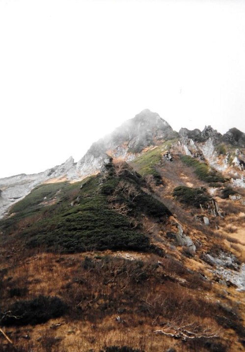
The next morning, after a bowl of warm oatmeal, I set off into a torrent of gray mist and howling winds. The lower pressure system’s grip on the mountain refused to budge. I crawled up along the loose rock of the ridge, around pockets of brush pine, carefully stepping over the bellflowers and avens, serenaded by the cries of ptarmigan hopping among the dew-stained rocks. I reached the summit after laboriously picking my way along the saber-toothed ridge, resting among the wind-weathered rocks in order to catch my breath from the aerobic alpine workout. The wind drown out the sounds of civilization, while the clouds erased all traces of mankind.

usugi1

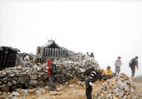
There’s something strangely soothing about sitting in the middle of a cumulus cloud. The world appears no bigger than a 3-meter bubble. Solitude sets in as if in a drug-enduced dream. Feelings and thoughts, once buried deep inside, boil to the surface like the eruption of an emotional geyser. Lost in contemplation, the minutes fly by as though carried by migratory birds as you are eventually snapped out of your sequestered trance by a group of yappy obachan. And so it was, in a dazed stumble that I dropped off the eastern ridge briefly to a modest hut perched just a few steps beyond the haze. Late risers milled about, preparing for the short jaunt to the high point before turning their attention to other peaks along the treeless ridge. I continued the descent, passing by an smaller unmanned hut before dropping out of the cloud and back into the deciduous forest alive with kaleidoscopic foliage of burnt umber and aureate golds.

usugi3

Meandering like the banks of the Tenryu river, the route skirted back and forth between herculean rock towers, with narrow wooden footpaths awkwardly anchored to the vertical faces. Signage stresses the importance of careful footwork, as every season a few unfortunate hikers end their careers in the craggy depths below. The mountain gods were favorable in this outing, allowing safe passage through the trickier bits as the angle eased a bit before dropping sharply again towards the idyllic tourist enclave of Komagane. At the bottom of the valley, just as the start of the big climb I had just put behind me, a brave husband-and-wife team were just setting off on their climb. The wife, stunningly beautiful despite her advanced age, put forth a proposal in impeccable Enlish: “You should marry my daughter.” Not used to such bold requests, I politely came up with a valid excuse. In hindsight maybe I should have at least asked her to show me a photo!

usugi2

The trail eventually tossed me out into a snowless ski field which led me to the shores of a modest lake and the completely deserted youth hostel, which happily took me in even though I was the only guest. I spent a relaxing evening watching the constellations by the side of the lake before tramping up the pavement in the morning to Komagane expressway interchange. After waiting about 10 minutes, I caught a ride with a basashi (raw horse) salesman who spend most of the ride to Nagoya on his cell phone making sales calls. He dropped me off at Ichinomiya rest area, where I was able to thumb a ride with a Korean guy all the way to Osaka. He had lived in LA for 4 years and spoke flawless English. His father owned a kimchee factory in Tsuruhashi and he was on his way back from a meeting with one of the distributors. The two Hyakumeizan in the Chuo Alps were now off the list. With only 2 months remaining in the year I hoped to conquer a couple of more peaks before the snow drifts became too deep.

Read Full Post »

Back in 2004, Osaka residents were still afforded the luxury of the overnight train running nightly from Osaka to Matsumoto. Though more expensive than the bus option, the train offered the additional comforts of being able to lay across a row of seats in the fetal position. An eye mask and earplugs were all that was necessary to enjoy a few hours of deep sleep before the 4am arrival in Matsumoto. Alas, those days are long gone, with JR West cutting all train services that weren’t turning a big enough profit. On this particular occasion, I disembarked at Shiojiri station, jumping on a local train to Okaya before turning further south to Komagane station, the gateway to the Central Alps. From there a bus whisked me to Shirabi-daira, the most popular entryway to the higher peaks above.  A ropeway station occupied one side of the behemoth parking lot, and already a long queue snaked around the corner. My plan was to save time and energy by allowing modern technology to taxi me up to 2400 meters, but I hadn’t planned on the autumn crowds. I bought a ticket and reserved my place in line for the several hour bottleneck. By the time I had made my way to the front of the line it was approaching high noon, which didn’t leave much time for lunch or loitering about.

kisokoma1

At Senjojiki, staff were prohibiting people from starting the traverse over to Utsugi-dake. The maps said to allow for 7 hours for the journey, and the powers that be were trying to avoid an accident like the one that would plague the mountain nearly a decade later.  Sometimes a little white lie is the best course of action: “No sir, I’m not headed to Utsugi,” I stealthily declared. “Camping up near Naka-dake”. Sure, I was planning on climbing Naka-dake but had no intention of staying there.

kisokoma2

The top of the gondola is anchored by a luxury hotel whose clientele are more interested in the hot baths and mountain views than the alpine peaks hovering close at hand. The lodge opens up to a vast meadow of high-altitude flora that rises to the vertical cliff faces of Mt. Hoken, Japan’s very own miniature version of the Dufourspitze. Hoken claims a few lives every year from unfortunate victims who lose their footing on the chain-draped precipice walls. Scanning the horizon further right, the contours ease to a col strewn with boulders the size of luxury liners. A gap in these igneous monsters marks the route for passage to the summit plateau of Mt. Kiso-Koma, the highest peak in the entire Central Alps range.

kisokoma5

It was this narrow passageway that I reached, just 30 minutes from the concrete of the hotel. The wind and cloud met me there and accompanied me all the way to the top. I stopped on Naka-dake, dropping my gear at the junction to Mt. Hoken before dropping to a long saddle with nothing on my back except for my rain jacket. Precipitation from above, perspiration from below made for a damp combination, but I stood on Kiso-koma’s broad rise just after 1pm to the disbelief of those hikers who had started in the early morning hours. I didn’t loiter long, for I still had a considerable amount of ground to cover before dusk.

Grabbing my gear, I crossed under the rope draped across the entrance to Hoken’s crags. There were warning signs everywhere that the peak was not for beginners, but up and over was the only way that I could save precious time on the traverse over to Utsugi. Visibility was poor, the footing even poorer, but I used the chains to propel me through the sketchy bits of wet, exposed face. The cloud hid the life-taking drops, making the route appear less treacherous than it may have been under clear skies. Down the other side, the path flattened out and I picked up speed lest being spotted by the officials a short ways off to the left by the hotel entrance. I heard a loud “Oi” but ignored it and disappeared into the mist. I knew they wouldn’t follow, especially since I had momentum and gravity on my side.

kisokoma3

I honestly don’t remember much about the ridge. In the heavy cloud cover I really could have been anywhere. The scenery looked just as it had during my earlier voyage through the Northern Alps, and if I closed my eyes and reopened them, I could mentally transform myself anywhere around the globe. This virtual time traveling worked wonders, and I soon found myself on the summit of Mt. Hinokio, faced with an important dilemma. A few minutes down to my left lie a free emergency hut, but if I pushed on further, I could have the comfort and warmth of a soft futon. Time check: 4pm. I still had at least an hour of daylight and had done well to make it this far.

kisokoma4

I opted to push on, through another area of long climbs and even longer descents, the longest of which dropped to a narrow saddle just before the knife-edged contours of Utsugi’s pyramidal form. Here I found my home for the night, a cozy mountain hut with a jovial owner and fresh water a short trot towards the valley. The last rays of the sun peeked out from behind their curtain before dropping behind Hakusan and the rest of the mountains of Ishikawa Prefecture. Perhaps this was an omen that tomorrow would bring better tidings and more cooperative weather.

Read Full Post »

The new day dawned bright and clear. Groggy-eyed, I stumbled through the streets of Urawa until slipping into a sparsely populated train to Omiya, where the Shinkansen whisked me to Minakami and I once again found myself climbing the steps from the tunnels deep within the bowels of Doai station. It was hard to believe I was staring at these same walls just 24 hours ago before my spontaneous decision to give Tanigawa a miss. Now I had no choice, but at least I had the weather on my side….or so I thought.

tani3-5

Asphalt guided me to the gondola entrance, but I just couldn’t give in to such technological catalysts. I had to climb the mountain from the bottom, all of it, so I ducked through the weeds, following a gravel trail that ran roughly parallel to the ropeway pylons. Birds sung gleefully, hidden from view by the thick foliage framing the concrete of the river bed. Brisk my pace led me, higher and higher towards the ski resort at Tenjin-Daira. To my right, buried somewhere in the jungly thicket, sat a faint trail that would take me towards the main ridge of my target peak, but without any signposts or markers, I overshot the turn-off until realizing it much too late. The route I followed banked left through a series of long switchbacks until dumping me right into the middle of one of the ski runs. Large ruts the size and contour of a small tanks lay deep in the dry mud. Ah, this must be the path used by loaders for construction and maintenance work.

tani3-2

Stumbling onto the lush greenery of the open fields, I sought refuge from the baking rays of nature’s ultraviolet oven. The intense heat, high even by September standards, left me parched and withered. I lay my head under the faucet of the bathroom sink, sucking thick morsels of everyone’s favorite mix of hydrogen and oxygen. Perspiration, mixed with the fresh flow from the taps, dripped from my already soaked clothing, creating a small salty pond at the base of my feet. I inhaled mouthfuls of refreshing liquid until equilibrium returned.

tani3-3

Shortly after the lunchtime sirens echoed in the villages far below the abyss, I reached the collection of boulders indicating the summit of the first of Tanigawa’s twin peaks. The other lay along the wind-carved crumbly spine. Not knowing which of the two were higher, I opted to climb them both, picking my way among the hunks of cretaceous granite sculptures for the better part of half an hour before reaching the secondary peak. Here the winds threatened to send me tumbling down the cliffs of the eastern face, so I dug in the heels and rummaged through the pack for some alpine delicacies disguised as a bag of mixed nuts and chocolate. Just below my plastic bag of goodies, sandwiched between my soft-shell and fleece, I located my map, which brings up an unfortunate habit of mine. In my frenzy to scale the peaks on Fukada’s list, not only do I end up taking far less breaks than normal, but due to my laziness, useful gear stays unused in the bottom of my back. Map? Nah, too much of a hassle to pull it out. Rain jacket? Again, unless the skies open up I just end up dealing with the mist.

tani3-4

Anyway, my maps showed that I indeed reached the designated top of Tanigawa, so instead of the long traverse over to Tairappyo, it was back to the ski resort I retreated. Shortly below the summit rocks I dropped down out of the cloud line, revealing the near-vertical drops off the eastern edge. If I wanted to end it all, I could have simply moved a meter or so to my left. Rows of bluish-gray mountain stretched out to the horizon, folding over on one another like a stack of futon being stored in the closet. I recognized the rounded contours of Hotaka, the peak I had been on just a few days prior. To the left I saw what appeared to be Makihata, with the trio of Echigo peaks nestled beyond. The stroll back to the trailhead was non-eventful until I reached the bottom of the gondola, where I was able to hitch a ride all the way to Saitama.

tani3-1

With 3 peaks knock out in 3 successive days, I turned my eyes towards the remaining summits of the Kita Alps.

Read Full Post »

There’s no doubt about it. Mt. Yotei was going to take a lot of planning if I wanted to pull it off. I had a 22-hour window between arriving in Otaru and departing in Muroran, and I needed every minute to count.

yotei5

The ferry rolled into port around 8pm, and I was one of the first ones off. Hailing down a taxi, I rushed to Otaru station in time to catch a southbound local train headed for Niseko. I made it to Kutchan station shortly before 9pm, where another taxi whisked me along route 5 to the turnoff at Hangetsu lake. I thanked the driver, dropping my heavy pack at the base of the toilets while studying the maps. A handful of tents were tucked away in the shaded corners of the tennis-court sized campground, but I wasn’t planning on loitering. A night challenge was in the works – If I could only find the trailhead.

yotei2

An unmarked gravel forest road led towards the direction of my target peak. Donning the headlamp, I eagerly followed, cautiously keeping my wits about me in case any brown bears came out to size me up. After half an hour of steady climbing, the road spit me out into a vast meadow of wild grass and weeds. In the dim light of the moon I could just make out the outline of Yotei’s conical crown. Expecting to find a signpost or signs of human encroachment, I was left with nothing but a forgotten forestry cul-de-sac. Dejected, I retreated back towards the parking lot. A few steps into my descent my headlamp flickered twice before extinguishing myself. It was dead, and I didn’t have a spare set of batteries. I picked my way back, tripping over tree roots and loose rocks before collapsing in a heap of sweat and fatigue at the base of the toilet block. Stowing my gear, I glimpsed a shiny piece of metal out of the corner of my eye. Retreating to the rear of the small shack, I found a giant signpost marking the entrance to the trail. In all my haste to race up Yotei I hadn’t bothered to search for the start of the trail in the campsite itself. Well, at least my headlamp malfunctioned here and not halfway up.

yotei1

I abandoned my nocturnal pursuit, ducking into my tent just after 1 in the morning. I didn’t bother with the rain fly, as I’d be up at first light in a couple of hours anyway. I set the alarm for the un-buddha-ly hour of 4 and drifted off into a deep slumber. The morning call came, and I woke myself up with a rapid bowl of oatmeal and dried fruit before strapping on the gear and hitting the trail. The path was incredibly easy to follow, and in hindsight I probably could’ve done it without a headlamp. The switchbacks, as in most stratovolcanoes, shorten the higher you go. At first you only switch directions every 10 minutes or so, but towards the crater rims those turns come faster than a downhill slalom course. Across the valley, Mt. Niseko Annupuri shined brilliantly in the early morning light, with a isthmus of puffy cloud rising rapidly from the ski-resort town of the same name. The clouds rose in direct proportion to my gains in altitude. It was as if they were racing me to the top, and since I didn’t want to be deprived of a view, I quickened the pace. I made it as far as the 9th stage point before I lost the footrace with the cumulus. Fog enveloped me in much the same way the smoke machines eats people at a Megadeth concert. I hunched over, catching my breath while trying to regain composure for the final push to the high point.

yotei3

When reaching the rim, I headed counterclockwise, arriving at the high point just as the sun peeked out of the cloud for an instant. I raised my camera to capture the scenery. The click of the shutter was followed by the click of plastic, which was further followed by the door of my camera swinging completely open, exposing all of my film to the direct light. Somehow the latch had broken and I had no way of closing my camera. It was still fully functional, so a quick fix was in order. I pulled out my first-aid kit, affixing band-aids all down the side of the camera until somewhat secure. Still, I knew all of my film would be damaged. This was in the days before affordable digital technology, and being stuck at almost 1900 meters above the nearest camera store meant I had no alternative way of documenting my climb. With my head hung low, I continued the rest of my circumnavigation in a childish sulk. Just to make matters worse, the clouds lifted at times, revealing the verdant greenery of the crater itself.

yotei4

In order to offer better access I dropped off the northeastern flank of the dome, crossing a vast field of wildflowers stretching out in front of the modest mountain hut. From here I entered the Makkari route, a knee-knocking, ankle-twisting descent that dropped straight off the peak into the dense forests of beech and birch. The route spit me out in a extensive campground bathed in a sea of soft grass. I stopped here to rehydrate and refuel before following the slope out to route 66. Turning left, I strolled along the busy byway, looking for a shoulder along the road where I could safely try to hitch. As I was walking, minding my own business, a car pulled to a halt and ushered me in. After showing me the sights of Lake Toya, the elderly gentleman dropped me off at Nagawa station, where I caught the train to Muroran with plenty of time to spare before my evening ferry ride to Aomori. My time management had rewarded me with another successful tick off the list.

Read Full Post »

With a trip planned to Hokkaido in less than a week’s time, I scurried through the guidebook looking for one last peak to check off the list. The biggest problem with climbing the Hyakumeizan comes when you’ve already scaled the ones with easy access and are left with mountains in out-of-the-way places. Hence my current dilemma: which mountain would serve as my 53rd victim?

IMG_0915

Nasu seemed approachable: a quick shinkansen ride from Tokyo, followed by a short-ish bus ride. Sounds great on paper until you realize that I’m not based in Tokyo, further complicating matters. A night bus it was, dropping me off at Ueno just as the biggest star in the solar system peeked over the eastern horizon. With such an early start, I arrived at the parking lot for Nasu Ropeway before the gondola actually started running. It made no difference, however, as I wasn’t planning on the easy way up.

On the short paved walkway that led to the start of the path to Mt. Chausu, I raised the viewfinder of my digital SLR to my right eye and snapped a shot of the early morning cloud wisping from the summit plateau. The camera soon went black, unresponsive to my constant tinkering. I even tried changing the battery but nothing. Completely dead. There would be no photos on one of Tohoku’s most picturesque volcanoes.

Dejected, I placed my new deadweight at the bottom of my pack, vowing to return in due time to capture the scenery on film. For now I flew up a path towards a deep col below Mt. Asahi. Scores of schoolchildren stood by the wayside, allowing me to pass. They were on a school excursion up to Chausu’s crater rim, and commendable they were for not opting for the luxury of the gondola, though in their case it may have been more of a financial decision for the teachers involved. Regardless, I gave a few high-5s before darting past them. When I hit the ridge, it was simply a case of following the maze of paint marks higher and higher to the top of my first peak, where the igneous rock garden did not fail to impress. The majority of hikers simply come to this point, snap a few photos of the crater, and head back to the comfort of the souvenir shops below. Hyakumeizan baggers, however, have the added task of traversing over to Sanbonyari, the official high point of the mountain range.

The path back to the col was manageable, but the next section to Mt. Asahi was a chain-laden exposed traverse on a cliff of loose pumice and pebbly ash. Long drops to my right made every footstep critical. Fortunately the heart-pumping section was short, and after the cliffs of Asahi, the route dropped to a vast plateau filled with lush, verdant grasslands, contrasting greatly with the smoldering fissures slightly to the south. There were a few intermittent peaks of gentle ups-and-downs, with wooden boardwalks in the flatter areas to protect the fragile vegetation. The final push to Sanbonyari was long and relentless, taking nearly 90 minutes to reach. Half a dozen other trekkers relaxed on the narrow summit when I arrived, sitting on ‘leisure sheets’ while enjoying their immaculately packed lunch boxes. The peaks of Fukushima lay thick in dark cloud, while the vistas back to Chausu were also cut off by a secondary layer of fleet-footed cumulus.

The route back to the start was non eventful, which in my case meant no bear encounters, no twisted ankles, and no unexpected surprises. Back at the parking lot, I walked down the road for 30 minutes, stopping by a hot spring for a well-deserved bath before flagging down the bus back to the station. Nasu was a nice warm-up for the long-awaited matchup with Hokkaido’s greatest cinder cone Mt. Yotei, whose sheer scale makes up for its lack of firepower.

Read Full Post »

10 minutes. If only I had bothered to check the bus schedule before setting off from Tokyo. The next bus wasn’t until early afternoon, but I had a mountain to knock off before returning to Osaka and couldn’t waste time loitering in Maebashi. I consulted with the wallet, trying to determine if the finances could handle a taxi ride up to Lake Onuma. The door of the taxi opened: I used my best Japanese to ask about the damage. “About 7000 yen”, replied the white-gloved, immaculately groomed chauffeur. If climbing the Hyakumeizan didn’t bankrupt me, I don’t know what would.

IMG_0667

The taxi ride itself was non-eventful, but as we climbed the asphalt switchbacks up and over Hachou pass, I was shocked to discover Mt. Akagi covered in an expansive shroud of greyish fog. There was no turning back, however, as the financial investment meant I’d climb this peak – rain, cloud, or shine. Once out of the taxi, I checked the bus schedule for the return journey and scooted down the paved asphalt byway to the start of the trail to Koma-ga-take.

IMG_0666

Buzzed with the excitement of the impending climb, I marched up the steps built in the hillside trail like a long-lost samurai in search of its master. After hitting the ridge, I turned north, topping out on the horse-shaped peak just in time to see the clouds lift and Akagi’s majestic form pop into view. The weather was absolutely wonderful in the late spring sunshine. The peaks of Nikko sat gracefully to my right, while the bushy summit of Mt. Kurobi rose towards the sky, a long col between here and the top. Bare of foilage, the tree branches waited patiently for winter to release its brittle grip. A large patch of snow hung firmly on the shady reaches of the western face as if expecting frozen friends to return, but with May just around the corner, it would be a long wait.

IMG_0669

After dropping to the col, the route skirted a short knife-edge ridge before ducking into the dense thicket of trees just below the high point, which was marked by a small unassuming shrine. Resting for a brief moment, I turned towards the lake, following a path whose designers had a shortage of patience when it came time to lay out the route. Perhaps they were just following the prints of our 4-legged friends, because it was easily one of the steepest and gnarliest trails around. Step after unrelenting knee-knocking step it dropped, ignoring geographical features en route to the shoreline, where the roadway provided much-welcomed relief to my aching joints. I returned to the bus stop with plenty of time to spare until the next bus, surveying the explored pages of my guidebook in search of more of Gunma’s unclimbed treasures.

Read Full Post »