Feeds:
Posts
Comments

Archive for October, 2009

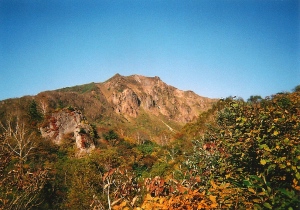
The most direct route from Matsumoto to Osaka is not up and over a 3000m high volcano. Regardless, I somehow convinced myself that climbing Mt. Norikura is indeed on my home and I’d be foolish enough not to drop by and say hello. This justification had nothing whatsoever to do with the previous day’s soggy ascent of Mt. Yake. Nor did it have any connection to the picture perfect weather that presented itself on a wonderful autumn in early October.

norikura1

I checked out of the hotel early and boarded the train to Shin-shimashima, where a bus was waiting to whisk me to Norikura-kogen. From there, I queued up for the long, windy shuttle bus to Tatami-daira, the site of a recent bear attack. The overdeveloped plateau, situated at 2700m above sea level, cuts a good 1000 vertical meters off of what used to be a challenging climb. The massive parking lot is a testament to the extraordinary crowds that swarm the peak during the summer months, but on this calm, cool Monday morning there was hardly a soul in sight.

norikura2

I flew up towards the summit of Mt, Fujimi, only to be slowed by an endless array of wooden steps built into the exposed hillside. “Perhaps I should’ve done a few laps around the parking lot before setting off,” I admitted, realizing I was an early victim to the thin air. Panting like a out-of-shape St. Bernard on a hot, muggy day, I tiptoed up to the top of the peak, where, on a clear day, the conical shape of Mt. Fuji stands out on the horizon. Clarity wasn’t a problem on this particular morning. Even though I could see every other peak within a 200km radius, Mt. Fuji and the peaks of the Minami Alps were playing a game of hide-and-seek among the convective clouds.
norikura3

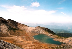
Mt. Norikura, like its more sacred neighbor Ontake to the south, is a volcanic plateau darted with
scenic volcanic lakes. In fact, most of the visitors stay on the asphalt trails well below the semicircular peaks above. I had Mt. Fujimi completely to myself, but ran into a few groups as the trail met up with the concrete again. I didn’t mind, though, as the outstanding weather more than made up for the unwelcome companionship.

norikura4

Scooting along on a concrete path, past a large, well-equipped mountain hut, I finally caught a glimpse of the summit of Ken-ga-mine, the high point of Mt. Norikura. With my body finally acclimatized, I flew past crowds out crawling pensioners until reaching the large shrine on the peak. Panoramic views in all directions more than made up for the misty drudgery of the day before. Mt. Yake stuck its steaming tongue out as if to tease me for climbing in such bombastic conditions. “Revenge will be mine”, I vowed.

norikura5

After the necessary summit proofs, I retraced my steps back to the parking lot and caught a bus towards Takayama and then a train back to Osaka. Mt. Norikura definitely thanked me for dropping by on the way home, and wished me luck on my upcoming attempt of Mt. Arashima, mountain #39.

Read Full Post »

As the shinkansen whisked its way towards Koriyama station, I pored over the maps and reflected on the mayhem of Nikko. Why couldn’t I just accept the fact that I’d knocked off 2 gargantuan peaks over the last 2 days, and head back to Osaka in peace? Logic and determination aren’t the best of friends when a man is on a climbing mission.

bandai1

The last train rolled into Inawashiro station shortly before midnight, and I quickly scouted out a dark and quiet area just north of the station to roll out the sleeping bag. I was tempting fate by not putting up the tent, but fortunately the weather deities continued to be kind to me. I awoke before dawn with an unobstructed view of my target peak. I pulled out my camera to capture the scenery, realizing to my grave horror that I had only 4 exposures left and no extra film. 1 photo would have to be saved for the summit sign, so that left just 3 photos for an amazing mountain with foliage at its peak on a clear, cloudless day.

bandai2

I meandered through deserted streets until finding the path at the bottom of one of the ski lifts and started the steep climb. I’d like to have a talk with the cruel soul who decided to lay a trail up the black-diamond run without a single switchback, but I guess it saved a bit of mileage in the end. Gaining elevation quicker than Boeing 757, I reached the summit of Mt. Akahani around 7:30am, where the towering figure of Bandai’s volcanic summit came clearly into view. Click. 2 more left on the roll and lots of incredible scenery ahead.

bandai3

The path descended into a vast area of marshlands, with pockets of active thermal vents hidden in the dense undergrowth. This col is actually the remains of an ancient caldera, and the high point of Mt. Bandai is just one of several peaks towering on its rim. Warning signs had me sticking snugly to the trail, as had tales of less fortunate victims succumbing to the deadly gases. Click went the shutter at the low point of the flatlands, as I stowed the camera deep into my pack, lest I should give in to a sudden impulse. “The last of the film will be used on the summit”, I declared.

bandai4

Once out of the col, the course turned south, following the flank of the main ridge to the summit. Paint marks on the rocks were a reminder of the foul weather found throughout most of the year, but on this particular day you could clearly see where you were going. A short while later I reached a large trail junction connecting the peak with the more popular route from the north. A small hut selling refreshments sat in the pint-sized clearing, but alas they weren’t stocking film. The crowds also increased somewhat on the final push to the high point. Lake Inawashiro, my starting point earlier in the day, sat calmly below, while Mt. Azuma and Mt. Iide, ny only 2 unclimbed peaks in Tohoku, watching on with eager eyes. Snap, snap. The sad sound of my camera rewinding the depleted roll. Despite having taken the least number of shots out of any of the 100 mountains (except perhaps for Mt. Ishizuchi, where I couldn’t even take my camera out in the torrential downpour), I still have a strong memory etched into my brain, for I can close my eyes and retrace the exact route, 3 years after the fact. The power of a long but unforgettable weekend.

Read Full Post »

“Itatata”. Somehow the words flowed out much easier in Japanese in the early morning darkness of my first full day in the alpine back country. Stiff as a board from the record-breaking mileage of the previous 19 hours, I slowly rose from my cozy futon on the 2nd floor of Sugoroku hut and made my way ever more slowly towards the cooking space on the ground floor. “I~ta~i“. The pain was the unmistakable result of damaged z-band filaments in the femoral region, more commonly referred to as incredibly sore thighs. The ‘hair of the dog’ approach seemed the most feasible option, so after a quick breakfast, I packed up and started burning more muscle.

washi1

The frost clung gingerly to the alpine flora as a gentle easterly breeze brought forth the good tidings of a stable high pressure system. The stars quickly gave way to the horizontal glow directly behind, revealing two options for my first ascent. I could either continue on the ridge for the short steep climb to the summit of Mt. Sugoroku, or take the easier right fork towards Mt. Mitsumata-renge. The stiffness and soreness in my lower extremities subconsciously nudged my body onto the right fork as if in a peyote-induced trance.

washi2

The faint path grew clearer with each advancing step, thanks in large part to the phenomenally clear autumn air that brought an unusually bright glow. The trail trudged down through an immense col before cutting a line towards the saddle below Mt. Washiba’s round, husky top. It took the better part of an hour on a relatively easy route to reach the main ridge line again, during which time I missed most of what was certainly an incredible light show going on in the peaks hidden behind Mitsumata-renge’s bulky flank. “Next time I’m definitely sticking to the ridge line,” I promised.

washi3

I reached the hut and campsite on the saddle, filling up on water and provisions before starting the switchbacks up to the summit. Mt. Yari’s sharp spear was clearly visible in the distance, and I soon found myself staring down into a crater lake that looked mysteriously volcanic in nature. A little research done after the fact confirmed my suspicions and I definitely witnessed a rarity among the peaks of the Kita Alps: actually getting a glimpse of that elusive lake!

washi4

The summit itself was completely deserted in the mid-morning sunshine due to the massive throngs of people who scaled the peak in time for the sunrise. Sometimes it pays to get a ‘late’ start.

washi5

I pushed on, reaching the tiny hut below the peak of Mt. Suisho around 90 minutes after leaving the summit of Washiba. These two peaks are relatively close together and offer the rare opportunity to easily scale two of the Hyakumeizan in one day. I dropped my pack off at the hut and raced towards my second peak of the day, only to be met by a totally unexpected series of chains and ladders. It was such a drastic contrast from what I’d faced up until that point, but you can’t expect every peak in the Japan Alps to be a mid-afternoon stroll, can you? Summit photos without the presence of a single cloud – a definite anomaly in the fog-prone highlands.

washi6

I retraced my steps back to the hut, where the hut owner handed me a complementary apple. “Won’t be needing these tonight, as I’m closing up shop for the winter,” explained the grey-haired caretaker. I’d completely forgotten it was late September and I was beginning to wonder if Eboshi hut, my goal for the day, would be accepting guests.”Only one way to find out,” I said, and quickly commenced the long slog.

washi7

I turned east, entering a north-south ridge running parallel to the main Kamikochi-Tateyama trekking route. Also known as ‘Ura-ginza’, the trail I was now on would take me all the way to the Sea of Japan if I felt so inclined. I have dreams of a Kamikochi to Hakuba trek in the future if my health ever improves significantly enough to warrant it. The first major peak to scale, Mt. Noguchi-goro, is actually the same height as Mt. Washiba and the intimidating path to the top took me well past lunchtime to knock off. It wasn’t that the trail was all that difficult, but more of a matter of giving my gelatinous legs a much-needed pep talk. I collapsed on the sandy summit, breaking out supplies for a long-overdue lunch break. Staring across the vast valley towards Mt. Suisho, I now found out why this peak is also goes by the name of Mt. Kuro, or ‘black peak.’

washi8

A full stomach and a half hour of rest do wonders for a battered body, and I rose with renewed vigor. A short decent landed me at Noguchi-goro hut, which was also finishing up a short summer season. “You’re in luck, Eboshi hut is still open for business”, explained the husband-and-wife team. “Help yourself to as much water as you’d like.” It was basically a downhill walk from here to Eboshi, which took around 2 hours. Or so I’m told, for I honestly have no recollection of the path, scenery, or terrain. I’d started the morning in a sleepy trance but was ending it in a drunken stupor, choking on lactic acid and fueled by the prospect of a warm place to sleep.

washi9

MIraculously, I rolled into camp in one piece and had survived yet another absurdly lengthy day on the slopes without making any costly mistakes. That was all about to change, however, on Day 3 of what was quickly becoming the ‘mother of all treks’.

Read Full Post »