Feeds:
Posts
Comments

Archive for February, 2017


Amazing mountains deserve subsequent visits, and Mt. Ryozen is no exception. I became mesmerized by the Scottish feel of the summit plateau during my first climb on a frigid March morning, and dreamed of heading back in the autumn to take in the golden hues of the meandering grasslands. Noteworthy peaks are like a good bottle of bubbly – they are best shared and showed off to close counterparts, so I turned to my companions from the latest Gathering and settled upon a date in late November that just happened to coincide with a stable high pressure system.

IMG_1917

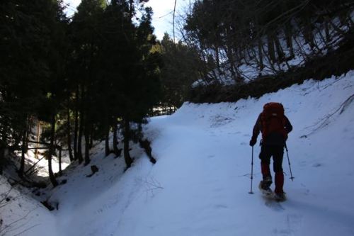
Miguel, Eri, Rika and I alighted at Samegai station in eastern Shiga Prefecture, where Paul D. was waiting with a warm smile and an eager look on his face. With such perfect weather at our disposal, such looks were well understood, as we were all itching to make full use of the brilliant daylight. The bus was set to depart in 15 minutes, leaving Eri just enough time to dash to the nearest convenience store to stock up on provisions for the long hike. From the bus stop to the summit, we faced a 7-1/2 km one-way hike, the first 4 kilometers of which were on a paved forest road will little to no vehicular traffic. We each hit the tarmac at our own pace, settling in on a rhythm while catching up the latest news. It was our first time to hike with Rika, a feisty Fukuoka native who had recently relocated to Kobe to work for Finetrack. Her sense of humor helped break up the monotony of walking on a road we easily could have driven in luxury.

IMG_1930

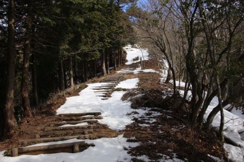
The waterfall route I had taken on my first visit was washed out in a typhoon some years ago, which necessitated our current, longer approach via the forgotten remains of Kuregahata village. The farming hamlet was home to 50 households during the Meiji era, but life was rough for the 245 inhabitants, as the winter snows brought accumulation of several meters, cutting off access to the larger towns of Maibara and Hikone. Residents slowly relocated to lower, drier ground over the ensuing years, until the strict food rations during World War II forced the remaining habitants to migrate towards the more populated enclaves. The final death blow was dealt soon after, as the local elementary school shuttered its doors and essentially hindered anyone to returning to settle. Nowadays the building foundations and vegetable fields provide campsites near the public-run mountain hut, which gives off an eerie, Blair Witch feel. We moved through the area swiftly, anxious to reach the warmth of the sun’s rays up on the ridge.

IMG_1964

The path switchbacks abruptly out of Kuregahata, reaching a mountain pass whose Kanji characters read “sweat wiping”. The name was most appropriate, for not only were we dabbing the sweat away from our brows, but we were also shedding excess layers under the pleasantly balm November temperatures. The trail hugs the ridge, with abrupt drops off the southern face towards the hissing sound of flowing water concealed by the burning foliage in full autumnal display. Our progress was brought to a halt more than once as nature put on a slideshow worthy of pause.

IMG_1941

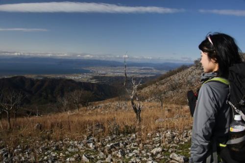
I was beginning to worry about our snail’s pace up towards the summit plateau, for we still had quite a long way to go just to reach the ridge before an even longer traverse to the high point. There were just too many distractions along the way – a rusty shovel hidden among the freshly fallen leaves provided minutes of spontaneous role play opportunities that could just not be passed up. With such an amicable cast of characters to our unfolding drama, we took it all in stride as the vistas began to reveal their magical selves. Humble villages hugged the jigsaw shoreline of Japan’s largest freshwater lake, as a ring of rugged massifs encircled the cove, mimicking the masts of warships ready to set sail at the slightest sign of trouble. It was in these broad flatlands that Japan’s most intense struggle for unification took hold that ultimately ushered in the reign of the Tokugawa clan and the seclusionist policies of the Edo era.

IMG_2004

We paused at one such overlook, admiring the views when a party of three elderly hikers greeted us on their descent from the rocky plateau above. Upon ushering our greeting, the trio responded with an air of recognition, as if they were being reunited with a long-lost friend. “Didn’t we meet you on Mt. Amagoi?”, inquired the tallest of the three. During our ascent of a peak just across the valley, Paul and I did run into these good-natured folks, who informed us about the Suzuka 12, a supplementary list to the original Suzuka 7 mountains that included 5 extra peaks on the Shiga side of the range. This time around we posed for a commemorative photo before continuing on our push against the force of gravity.

IMG_2062

Soon the rolling hills of the true ridge came into view, and after a few switchbacks we left the trees behind and arrived on the summit of the first peak, marked by a signpost indicating that we were 70% of the way there. This proved an ample resting place for lunch, with a gentle breeze, unhindered views, and plenty of fresh peanut butter to go around. It would have been easy to give into temptation and laze around for a few hours, but summit fever soon took hold, as we pushed on towards the top.

IMG_2076

Looks can be quite deceiving, as the lack of tree cover revealed the surprisingly long ground we still had left to cover. I had come from the completely opposite direction on my first visit, so this was still virgin territory. After passing by an idyllic pond marked by a small shrine, the trail veered towards the right, rising steadily towards a parallel ridge line with ever-expanding views. At the crest of the knoll, the iconic hump of Mt. Ibuki came into full view, flanked on the right across a broad valley by the smoldering cap of Ontake. Closer at hand, the emergency hut stood guard, looking as if it were plucked from Grindelwald and plopped down on the soaring plateau. Mt. Ena held silent vigil across the subdued lowlands of Aichi, waiting patiently for the first flakes of snow to fall on the gentle curves of her sacred flank.

IMG_2110

Rika and I pushed out slightly ahead of the others, as we were soon approaching our 2pm turnaround time. The path dropped to a long saddle before the final steep push to the high point, offering panoramic views of the remainder of Suzuka’s foreshortened layer of contorted ridges. The summit boulders offered ample space for stretching out and taking in the splendid autumn views. From our eagle’s perch we tracked the progress of our fellow companions, tracing their outlines as they all successfully arrived on the top. We spent a few minutes taking in the wonderful scenery before reluctantly turning away for the long return to the bus stop. The final bus was at 5pm, which left us about 2-1/2 hours to cover the 7.5km descent. Just before pushing off a trip of French climbers arrived at the summit. They had heard about this hike from my very own Hiking in Japan website and were more than pleased with my recommendation.

IMG_2097

On the ascent, I spied a shortcut at the col that would shave about a half an hour off our descent and led our group on a narrow deer trail through the golden grasses. Our downward progress was steady but never felt rushed, and soon we regained the fiery foliage of the deciduous forest and slowed our pace to savor those fading tints of the waning season. Once back on the forest road we kept a constant eye on the clock, and with our perseverance we arrived back at the bus stop with just minutes to spare before the final bus of the day. At the station, the French trio we met on the summit came strolling in well after sundown. Perhaps I need to upgrade my difficulty rating on my website less one of my readers meet with ill luck.

IMG_2141


Read Full Post »

Folk tales in Japan are contentious affairs, with small villages in various provinces each laying claim to the origins of the stories. The legend of Hagoromo is no exception. Did the tale of the feathered maidens originate in Shizuoka Prefecture, where the Noh play of the same name suggests, or does the hamlet of Ami in Ibaraki Prefecture provide the source of the myth? None of the above, if the opinions of the denizens of Kyoto Prefecture can be trusted, for here in the rural lowlands of ancient Tango Province lies the oldest known Hagoromo tale. According to the legend, eight celestial maidens swooped down to Manai spring on the slopes of Mt. Hiji for a bath. An elderly couple happened upon the women and managed to grab one of the dressing robes. The other seven flew away in fright, but the lone maiden concealed herself behind a tree, for she could not fly away without her winged robe, or hagoromo. The couple explained that they were unable to have a child, and suggested that the maiden come live with them. She accepted on the condition that her robe be returned to her. The maiden soon became skilled at making sake which had magical curative powers, and the family became rich. After 10 years the couple asked the maiden to return to heaven, but she did not want to leave. The story continues and has a rather sad ending for which I will leave it up to your imagination, as the focus of my attention on this particular February morning is on the mountain for which the tale takes place.

IMG_4992

While it no longer goes by its former name of Mt. Hiji, Mt. Isanago is a fitting place for the birth of a legend. Indeed, the panoramic vistas from its bald summer perch overlook the massif of Mt. Oe, itself steeped in the tales of Shuten-doji and the Japanese Oni. Isanago happened to be on my list of Kinki Hyakumeizan, which I hoped to finished before the end of this year. It would be mountain #96, but with the recent snows blanketing the northern part of the Kinki region, it would take particular planning and caution. I scoured the weather reports and was finally gifted a glorious high pressure system. I boarded that 6:09am local train, the same one that I had use for my assault on Mt. Taiko at the end of 2016. I once again changed at Fukuchiyama station to the Tango railway. Fukuchiyama was still draped in a cool, thick mist, bus as the carriage pushed past the slopes of Mt. Oe, the cloak magically lifted, revealing the weather forecast was true to its word. Instead of alighting at Amanohashidate, I pushed ahead to Mineyama station and jumped in a cab for the 20-minute ride to the trailhead.

IMG_5010

“There should be no problem getting to the trailhead”, quipped my enthusiastic driver, who was convinced that the road would be plowed and free of ice. The rising sun also brought a rise in the mercury, as the residents were once again able to hang out their laundry and bedding after the last couple of weeks of inclement weather. As I paid the fare, I noticed an elderly hiker exit from his car with snowshoes in hand. He paused at the entrance to the forest road to affix his bindings, as I inquired about his intended destination. It turns out he was also heading for Isanago and knew the trail very well. Perhaps this Hagoromo tale has a hint of truth after all.

IMG_4900

“Go on ahead”, I explained, “I’ll catch up to you.” It look me some time to sort through my kit and to strap on the snowshoes, but I soon took my first few steps on the half-crunchy, half-soggy crust of rotting snow. Each step resulted in a drop in altitude of several centimeters, as I pushed on as best I could under the less-than-ideal snow conditions. Still, the decision to bring the snowshoes was a wise one, for it prevented me from post-holing at every step. I soon caught up to my companion and pushed out in front in order to share trail-breaking duties. In the shadier parts of the road the snow surface was more conducive to movement, but at every bend in the forest road, the lane became exposed to the sun’s rays, turning the road into a wet, sloppy slush that hindered forward progress.

IMG_4893

Soon I reached a sign indicating the trailhead lay 1000 horizontal meters ahead. It had taken a herculean effort just to cover the first 750 meters, and the exertion forced lines of sweat from the pores of my forehead. I bit my lower lip and pushed on until reaching a small open-walled shelter and toilet block. I sank on a wooden bench and started peeling layers, downing my bottle of Aquarius while cross-referencing my progress against the GPS data. As I raised the viewfinder to my eye for a quick snap of my surroundings, I noticed the exposure seemed brighter than usual. I reached around to the polarizer to give it a turn and realized that it was not there. I double checked my pack to make sure it didn’t fall off when I was sorting through gear at the trailhead, but my search came up empty. I’d just have to resign myself to a filterless day and search for my missing equipment on the return route.

IMG_4907

My break was leisurely, and my companion soon took over the trailblazing duties while I ate an energy bar. We had only 300 meters to go until reaching the official start of the trail, so I quickly caught up and let him stay in the lead for now. He explained that in the summer, hikers can drive all the way to the terminus of this paved escarpment, which I found hard to fathom at the moment, considering a meter of snow separated us from the asphalt below. As a polite gesture, I was ushered back into the drivers seat and broke trail up the steepened contours of the spur. A signpost explained that 1000 steps stood between us and the summit, but they were completely buried under the deep drifts. Despite this, the path was easy to pick out, as there was a steep drop on my left and a steeper rise on my right – ripe conditions for a snowslide, so I moved with speed, staying within earshot of my partner in case the entire hillside gave way.

IMG_4937

The exposed traverse was shortlived and we soon reached a junction on the ridge. To our right, a marker pointed the way to the women’s pond, the remnants of the famed Manai spring from the Hagoromo tale. I knew the pond would be frozen over and the shifting contours of the opposing hillside looked anything but inviting, so I turned left instead, where the wind-swept south-facing aspects revealed fragments of the summer log stairs laying exposed to the warm sunlight. I could see about a dozen stairs before a series of snowdrifts took over, so the snowshoes stayed on for the tiptoed traverse over the snowless sections of the path. My partner kept a safe distance behind, wary of my weight potentially sending down large unstable sections of spring mush.

IMG_4935

I reached a break in the tree cover at the top of the next rise, where a wooden bench completely free of accumulated snowfall beckoned me over. I settled onto the rectangular block, taking in the vistas across the valley to a splendid 180-degree angle. On my left, the perfect conical form of Mt. Aoba rose up, lending it the appropriate nickname of Wakasa Fuji. Just to the right, the twin bulges of Mt. Yura stood tall over the Sea of Japan that was just out of view. Closer at hand, the entire rolling massif of the Oe mountains held fort, cutting off access to the eastern part of Kyoto Prefecture beyond. It was a place worthy of a brief respite, but soon the offer of a 360-degree view proved too difficult to refuse, so I rose to my feet for the final push.

IMG_4943

The slope angle inclined, and the increased exposure also meant increased snow depth. Occasionally even the snowshoe could not prevent me from sinking up to my thigh, as I had penetrated one of the gaps on the edge of the stair column and plunged into the void. Pulling myself out proved easy enough and I wasn’t about to give in so close to my target. Further up the pitch eased, and a stone marker with ancient Kanji characters informed me that the summit was indeed near. A gentle traverse to the left, followed by a few kicks up the final mound and victory was ours.

IMG_4965

We sat down for lunch on a rock formation that just happened to have melted out of its winter hold, as if a maître d’ had been sent up earlier to clear a table of two. Or perhaps it was that feathered maiden looking after us. “The name’s Sakamoto”, explained my host “and I live over there”, pointing to the village at the foot of Mt. Yura. He was as impressed with my knowledge of Kyoto’s peaks as he was with my climbing resume. If he was in charge of hiring I would have gotten the job for sure. Sakamoto belongs to a local mountaineering club, but admits that he enjoys a nice balance between the larger group excursions and the solo endeavors.

IMG_4985

Lunch was soon finished, and Sakamoto and I were left with the tricky descent back to the junction, for the warm temperatures were making the snow even mushier. I cut switchbacks in the steep slope, and once we reached the first bare patch of dirt we took the snowshoes off completely, as the postholing actually improved our purchase and prevented a long, potentially dangerous slide. Once back at the junction the snowshoes went back on and we retraced our steps to the trailhead. The road back to his car was also a lot smoother on the descent, and just before reaching the pavement again, I found my camera filter lying in a patch of snow. Sakamoto gave me a ride back to Mineyama station, where I settled in for an afternoon nap before arriving back in Osaka in time for dinner. Peak #96 was now in the bag, but the final 4 peaks are perhaps the most challenging of all, especially with the particularly white winter. Perhaps I will wait until the spring.

IMG_4999


Read Full Post »