Well, I finally decided to get with the 21st century and have started creating visual content to go along with these written tozanlogues. Don’t fret—I will still continue to document my trip reports on this blog as I continue to catch up on two decades’ worth of hiking escapades. Feel free to follow the progress on my new channel if you’re interested.
The Suzuka mountains may best be known as Nagoya’s playground, but that doesn’t stop this Osaka resident from making every effort to explore the entirety of the range. It doesn’t hurt to have a local companion willing to share in this mutual love for the area. Hisao points his car in the direction of Mie Prefecture for a second look at Oike, the highest peak in the Suzuka chain. My first trip here involved a monumental effort after the closure of route 306, but with the Mie-Shiga thoroughfare once again open to vehicular traffic, we make a bee line to Kurakake-tōge, the easiest approach to the ridge.
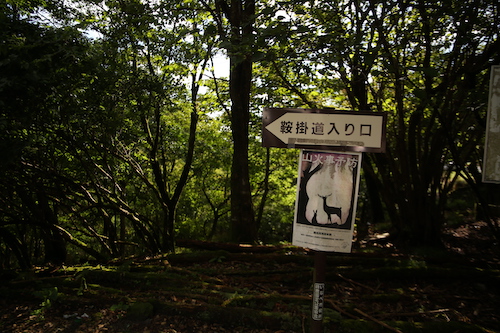
Under partly clouds skies on a weekend in late September, Hisao and I scoot into one of the last remaining parking places just outside of the Kurakake tunnel entrance. After a brief shuffle through our gear, we shoulder the packs and follow the switchbacks past the tattered ruins of a corrugated metal shack and onto steep slopes dotted with purple monkshood flowers shimmering in the gentle breeze pushing in from the east. The path narrows in places, with fixed ropes aiding in a hairy traverse across the dizzying drops of a narrow gully clogged with toppled timbers. It takes just 20 minutes to reach the junction on the ridge. A right turn here leads hikers to Mt Mikuni, a aptly-named summit situated directly on the border of Shiga, Mie, and Gifu Prefectures. It’s hard to believe that Gifu Prefecture stretches so far south to touch the Suzukas but Japan’s 47 prefectures have been crafted like an intricate jigsaw puzzle that defies belief.

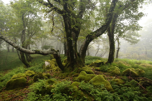
While the chance to place three different body parts in neighboring prefectures does seem tempting, we instead turn our attention south and head left on the well-traveled walkway toward Oike’s imposing figure. Our route follows an undulating ridge offering enticing vistas out to the blue waters of Ise Bay, with the path ducking in and out of the hardwood forest before skirting past a rusted electrical pylon in need of some upgrades. A dead grove of brown ferns sits to our left, while moss-coated oaks on the western slopes seem to make the most of their moist environs. After traversing up and over a few nameless bulbs on the ridge, we pop out onto a path of loose scree running through what can only be described as a massive moss garden. The maps call this place a Japanese garden and it is easy to see why.

Hisao and I let out screams of delight as we become enveloped in the unique scenery. To the north, the clouds have engulfed the ridges of Mt Ryozen but it does nothing to deter from our delight. Some may even say that the shade provides even better lighting to capture the verdant blanket of green beneath our gaze.

The line of electrical pylons stretching across the neighboring slopes, while marring the landscape, do little to detract our attention. Finding such a sprawling network of flourishing moss is rare indeed, and one has to wonder if Fukuda Kyūya would have chosen Oike instead of Ibuki if he had a chance to discover this part of the Suzukas earlier in his life.
Then again, the Hyakumeizan author may very well have been put off by the plethora of leeches that have invaded the land over the ensuing decades. At least on Mt Ibuki you don’t have to worry about having your blood sucked by the persistent segmented worms. Fortunately for us, the leeches prefer gullies to ridges and as we climb hiker into the encroaching fog, all thought of the gruesome creatures vanishes from our thoughts. That is, until encountering a trail-running duo on the summit of Mt Suzukita, the first of Oike’s multitude of smaller summit peaks.

“Which path did you take?” I ask, curious about the trail conditions further below.
“Kogurumi valley,” responds the taller of the two.
“How were the leeches?” I enquire, hoping to squelch my fears.
“No problem,” comes the reply.
“Then what’s that attached to your leg?” exclaim I, as a small leech clings comfortably to his left shin.
The runner reaches down and casually removes the bloodsucker as his companion looks on with disgust. I turn to Hisao as we both break into laughter at the scene unfolding in front of us.

Up here on the bare ridge we feel the full brunt of the winds, so after this quick exchange of unpleasantries Hisao and I continue our march south toward the summit plateau. The main route veers left at the bottom of the next col but Hisao beckons me to follow him to the right along a rarely-trodden path no wider than a foot width. Although we are most likely following the imprints of a deer trail, my leader truly knows where he is going as he has been through the area on snowshoes in winter. Hisao looks as if he’s on the hunt for fresh game to supplement his lunch.

We push through golden grasslands dotted with jagged Karst and sprawling carpets of lush moss until leaving the jungle behind in favor of the shaded canopy of the hardwoods entwined in a labyrinth of pastoral ferns and cushiony boulders straight out of Lord of the Rings.

It is easy to see why Hisao choses this route, for among the splendid scenery there are no other hikers, for they have all opted for the straight path to the summit for their proof photos and claims of having ticked another peak off of their mountain list. I certainly fell into that trap during my younger days, but when faced with climbing a mountain a second time, I tend to prefer a more thorough exploration of the slopes.

Carefully we pick our way through nature’s maze, taking great care not to disturb the delicate moss as the contours coax us off the northern flank and down to an idyllic tarn labeled on the map as Moto-ike (本池). As I study the map further, I realize that the entire area is dotted with hidden lakes and ponds which explain the origin of Mt Oike’s name, which literally means ‘honorable pond’.

With such breathtaking scenery spread out before us, our pace grinds to a crawl as every turn affords even more impressive scenery than the last. Lush forests give way to golden grasslands that further yield to sprawling fields of Kharst before once again leading us through yet more incredibly alluring forests, all under the playful eye of an overhead struggle between the swift-moving fog and the piercing warmth of the sun.

Eventually the forests give way completely to a colossal tableland straight out of an African textbook. I resist the urge to break into a Toto song so instead give out several yelps of joy as we clamber up to an outcrop called the Tengū’s nose, which give us a bird’s eye view of contorted folds of ridge encompassing the eastern past of the Suzuka massif. Just below the thick cloud bank the sunny shores of Lake Biwa peek out to say hello.

We race down from the cliff’s edge and make out way over to yet another outlook by the peculiar name of Botanbuchi. We rest among the rock formations and take in the mesmerizing views. It is now half past 11, and with very few hikers in sight, we settle down for an early lunch while alternating our gazes between the limestone cliffs disappearing from beneath our outstretched legs in front of us, and the unparalleled beauty of the golden tablelands stretching out behind.

“Are we really in Japan?”, I ask Hisao, wondering how I could have missed such incredible scenery during my first visit to this mountain. I thank Hisao profusely for convincing me to give Oike a second look, for it truly is one of the best peaks in the entire Suzuka chain.
Feeling refreshed, we meander through the plateau and up onto an adjacent ridge which takes us up and over a very crowded summit. Hikers area spread out among the jagged rocks, taking shelter from the winds and enjoying their midday meal. We opt not to loiter for anytime longer than necessary to snap a quick photo before ducking back into the lush forest and onto the well-trodden main route back to the car.

By now the fog has completely engulfed the mountain, bringing an entirely new dimension to the forests—one of enchantment.
This spell that the mountain has cast upon us is briefly broken as we skirt through a narrow valley and up into unexpected sunshine. Hisao once again leads me off-trail to a hidden pond called Kita-ike or northern pond, a tarn that very few hikers bother to take the time to visit as they all stick to the same up-and-back path to the high point. From the narrow shores of the waters we are able to follow the natural contours of the land as they lead us back to the summit of Mt Suzukita, thereby completing our rather extended loop of the summit.

From here it is simply a matter of retracing our steps back to the car and through the garden of moss, which never ceases to impress us even on the second time around.

On the walk back to the car, Hisao informs me that Oike is even more outstanding in the winter, and on our traverse back through the forest I do notice a piece of tape affixed to a tree that is used to demarcate the entrance to the winter route from the Shiga side of the mountain. Perhaps I will take Hisao up on his offer for a third round, for by now we can all realize that my fellow companion can be highly trusted with his mountain recommendations.
Posted in Kansai hikes | Tagged Hiking in Japan, Kansai 100, Kansai hikes, Oike, Suzuka mountains | 1 Comment »
My first visit to Mt Yokoyama entailed a tricky ridge scramble on rotting snow. Despite the difficulty with the snow conditions, the virgin beech forests clinging tightly to the mountain contours left an impression on me, and I vowed to return during the foliage season. Fast forward a few years to early November, and when pressed for a recommendation for an autumn hike, I immediately suggested to Hisao that he give Yokoyama a chance. Tucked in a forgotten corner of northeastern Shiga Prefecture, it would take an early start and a bit of planning to make it all work. Hisao happened to be in town for the Banff Mountain Film Festival, creating the ultimate opportunity to see our plan bear fruition. After a day of inspiring movies, Hisao and I head back to my home for an early night and long day ahead. We set the alarm for 4:30am, but I am awake by 4, excited by the promise of a beautiful day.

We hit the road by 5 for the two-hour drive and roll into the parking lot right at 7am. The last several kilometers along the rural road from Kinomoto see our target peak basking in the dawn light—even from here the climb looks impossibly steep as the massif literally towers over the sleepy hamlet. After using the barebones toilet facility, Hisao and I study the map and wait for 10 minutes until Yasu and Kaori pull into the narrow trailhead parking lot. Excitement resonates through the air as the crystal clear skies greet us like an old friend. Our route this time is the famed Shiratani Honryū, a scramble up a steep mountain stream: a direttissima earning the respect of all those who commit to the steep contours flanking the southern face of Yokoyama. During our first visit, the village caretaker rushed up to the trailhead in his utility truck to warn us off the route in winter but now it is time to give the route its due shine.

A rugged forest road doubles as our access route for the first few minutes before abruptly terminating at the water’s edge for the first of a series of river crossings. Skyward we gaze at the blazing foliage coating the spurs on both sides of our narrow channel. Greenery still clings tightly to the hillsides as if to ward off the encroaching winter. I take the lead, following the faint track higher up the constricted valley. At the top of a gentle rise I gaze ahead and spy a trio of hikers making their way up a series of jagged switchbacks that terminate at a forest road cutting sideways a quarter of the way up the mountain. Despite the human development on the lower flanks of the mountain, the forests have somehow been spared the wrath of the desecrators who have destroyed Japan’s natural forests by smothering them in cedar and cypress.

After an abrupt drop flanked by fixed ropes to the river and a short scramble through a side tributary, we reach those switchbacks and make our way up to the forest road, the final few steps made easier via a steel ladder flanking the two-meter-high concrete retaining wall. Here we turn left on the gravel road for 100 meters before leaving the human development for good by returning to Shiratani on a path splitting off the right shoulder of the lane. Yet more river crossings await as the three of us commence on a somewhat steep ascent past the multi-tiered Kyō-no-taki (経ノ滝) falls. We pause briefly to delayer and admire the ribbon-like cascade.

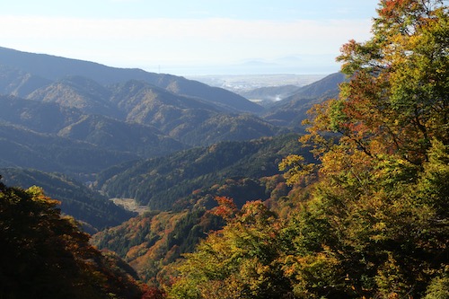
Left the path goes, straight up a rope-smothered slope in fact, to meet the start of a narrow spur still sitting in the cool shade as the sun has yet to lick these secluded corners of the gorge. We force ourselves up the near-vertical embankment and onto the relative safety of the spur that leads above the falls and onto yet another series of river crossings. The track soon reaches a clearing, affording tantalizing vistas back toward our route and further onward to Kinomoto and the shores of Lake Biwa. To say that the scenery resembles a landscape painting would be an understatement, as we could literally have gazed for hours, entranced in the utter beauty spread out before us.
Higher and higher we rise to meet the slivers of sun working their way down the slopes. The warmth that it brings is most welcome as we have spent the entire morning in the chilly shadows of the gorge, and up through a latticework of fixed ropes we ascend, reaching the base of the multi-tiered Gochōshi Falls. Hisao erupts in delight, as his hometown of Choshi (銚子) city in Chiba Prefecture shares the same kanji characters as this waterfall. We take our first break of the morning here, wiping the sweat off our brows while taking in the vistas back to the valley behind us. We share a few snacks and bask in the warm rays of sunlight. It is just past 9am and most other the other hikers are probably just beginning to set foot on the trail.

From here it is a straight shot up to the summit, but first we need to navigate up and over the falls. Fortunately a track to our left grants us passage along a narrow, somewhat dizzying rope-lined traverse tinged with autumnal hues. You really have to focus on the terrain here and not get spellbound by the splendid scenery and lose your footing.

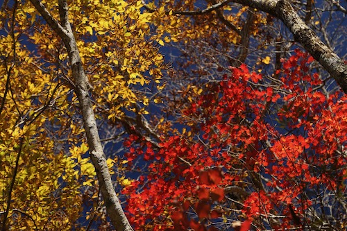
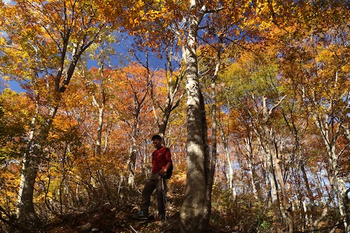
Above the falls the track veers left once again onto the crux of the route, as the angle intensifies. Fortunately for us, we have reached a different kind of intensity as we reach the peak of the fiery autumnal tones. I scream with delight at literally every step upward as a chorus of oohs and aahs follows.

Our pace grinds to a crawl and for good reason, for never in the Kansai region have I bore witness to such fierce colors set against only the most cobalt of skies.

At the base of a trio of horse chestnut trees towering toward the sky, I find a peculiar heart-shaped rock clinging to the steep hillside. Has it been placed here by a pair of star-crossed lovers, or just a lucky find among the scattered fragments of rocks interspersed among the freshly fallen leaves? Regardless, the golden hues of the broad-leaf chestnut provide a most fitting backdrop.

While the lightshow above is nothing short of stunning, a glance over to the neighboring spur sends us into an excited frenzy of shrills and adolescent screams.

I snap a photo at literally every step upwards, trying to capture just a tiny bit of the spectacle for others not lucky enough to witness nature’s perfection. Imagine how beautiful Japan must have been when every forest took on these deciduous tones every autumn. It is hard to find a mountain in Kansai that hasn’t had its slopes desecrated by the cedar planters, so when a completely untamed mountain presents itself for show, you had better pay it some respect.

Those words come to me in a semi-concussed state, for after navigating through a narrow gap in a rock formation above, I stand prematurely and smash my noggin up against a toppled beech tree, which has me seeing stars as I lurch forward to regain my composure. Luckily the smooth bark fails to create a puncture wound, so I can continue forward in a careful yet bloodless state.

Using this collision as an opportunity to slow up the pace, I gaze up toward my canopy of blazing reds and vivid yellows as we continue our steady pace along the ever-steepening spur. The contours on the map are so close together it’s a wonder there is any room for a path at all, and every 50 meters or so we clamber through some rock formations that have somehow managed to defy gravity as they cling to the rugged hillside.
Beech tree leaves do not retain their color for long periods of time, with the transformation from brilliant yellow to muted brown occurring over the course of just a few days, so we consider ourselves lucky with such perfect timing as to witness the brilliance of this autumnal performance.

The spur continues to steepen as we make our way through a network of bowed trees, crags and fixed ropes, punctuated at irregular intervals by rotting signposts clinging awkwardly to the gnarled slopes in a gravity-defying manner. Pink tape marks guide us upwards along the narrow spur, coaxing us along like signal beacons lining a crowded cove, but for us the harbor is crammed with towering beech, oak and maple. Finally, after the better part of an hour, the angle subsides and ushers us up onto the broad ridge of Yokoyama.

We pop out on the treeless summit at preciously 10:30am. A pair of hikers laze in the warm sun but apart from this duo, we find ourselves completely alone. One lonesome raggedy old prefab structure sits on the northern edge of the high point, looking even more lopsided that during my first visit to the mountain. Ignoring common sense, I scale the rickety metal ladder tied onto the side of the shack and scramble onto the roof looking for a glimpse of Hakusan to the north. Alas, the sacred peak is shielded from view by a series of smaller mountain ridges ablaze in autumn hues.

Lazing in the warm sunshine seems like the best course of action, and between mid-morning snacks our companion Kaori settles in for a power map while Hisao, Yasu and I gaze down at the shores of Lake Yogo, a tiny dot of a tarn as it appears from these hallowed heights. Yogo itself sits at the northernmost tip of Lake Biwa, separated by the sprawling ridgeline of the Sengoku-signficiant Shizugatake. The better part of 30 minutes is spent in such perfect reverie among the soothing air of autumn.

Eventually the four of us garner up the strength and courage to embark on the long-awaited walk along the spine of the range to neighboring eastern peak of Yokoyama. Although the main peak of Yokoyama is devoid of clear views, a short walk east takes visitors onto a narrow sliver of track affording vistas that can only be described as life-altering, for once slip down the rugged cliff face will do just that.

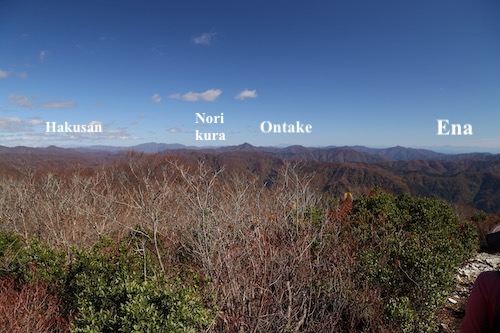
As we push on closer to the eastern summit, a solo hiker approaches on his way west toward the main peak, and as he passes, he offers us just the bit of news we were hoping to receive: the Alps are visible. This titillating snippet is all that it takes to send us in a frantic scramble to the east peak, where we do indeed find those ever elusive views north.

We can count no fewer than 10 Hyakumeizan on the horizon, in an expanse spreading west from Mt Arashima all the way across the horizon to Mt Ibuki on our eastern field of view. Between, Mt Ena looks on with envy as the faintly visible Chuo Alps run behind the imposing volcanic edifice of Ontake. Mt Norikura, Hotaka and Kasa also make an appearance along with the bald cap of Hakusan poking its snow-free head above a bank of white cloud.
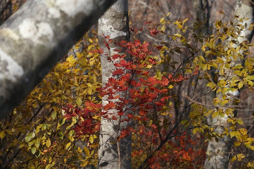
With a tinge of reluctance, we bid farewell to the glorious views and duck back into the bare virgin beech forests, which slowly come to life as we once again descend below 1000 meters and into the peak of the autumn blaze. The colors come gradually: at first a lonesome maple against a backdrop of gray beech but slowly the colorful canopy begins to overtake us.
And overtake it does, grasping us in a viselike grip as if to say “you will walk slowly and give us our due respect.” And we give into the temptation and do indeed slow our pace to a crawl, smiles spreading across our contented faces as we search for the right words to express our appreciation.

21 years of hiking in the Kansai region and never have I encountered such perfect hues of autumn color.
As with all good things, they must surely come to an end, as we pass into the lower depths of the forest and right into a small sliver of planted cedar hugging the edge of a dirt forest road. It looks as if the tree planters started their clear-cutting but stopped short of a full-on invasion, perhaps with a tinge of guilt at attempting to destroy one of the best forests in western Japan. Or perhaps the hallowed beech groves of Yokoyama are on borrowed time. Regardless, I grasp tightly onto the fixed ropes guiding me down an incredibly steep track to the forest road, which eventually leads back to our vehicle.

We top off our trip by a short visit to an obscure old ore mine that Studio Ghibli fans have taken to call a real-life version of Laputa, a perfect ending to our flawless autumn trip to Yokoyama.

Posted in Kansai hikes | Tagged Hiking in Japan, Kansai hikes, Shiga Prefecture, Yokoyama | 1 Comment »
Fueled by the momentum of Day 7, Ted and I head out on the backroads to Makino exactly a week later, under perfect azure skies and a stable high pressure system. This time around, we play it smart and come armed with two vehicles. Hisao and Yasu are en route from Nagoya and we set a rendezvous point of Kunizakai ski resort, the terminus of the Takashima Trail. Ted parks the car in the dirt parking lot of a shrine about 100 meters from the ski lift entrance and Hisao chauffeurs us to the sprawling lawns of Makino Kōgen.
Hikers mill about, drawn to the blazing foliage above the golden grasses of the plateau. A large SUV pulls into its parking space among a dozen or so other vehicles spread out among the campground lawn as the tent city begins to spring to life. The driver seems content with forking over the 5000 yen fee for a night’s tent accommodation, as the pandemic price gauging continues unabated. Our motley crew of hikers is happy with leaving the car camping world behind as the track ascends a series of log steps and ducks into the forest proper.
I am once again in familiar territory, having taken this route on two separate occasions, but the scenery and beauty of the tranquil forest never fails to impress. Ted, Hisao, Yasu and I chat casually, catching up on life as our track enters a tunnel of lightly tinted oaks beginning to show signs of chlorophyll depletion. Further on, a lone hardwood, ablaze in a brilliant reddish-orange tint sends us scrambling for our cameras. We keep a brisk, somewhat sweaty pace before reaching a rest gazebo, where we shed a layer and rehydrate. Spirits are high and how can they not be when blessed but such stunning autumn weather.
Our route edges us closer to a mountain stream, and once past a small concrete dam we enter the world of the mighty beech. Only the distant view of a giant electrical pylon standing guard on the ridge high above can detract from the natural splendor. As we reach 500 meters of elevation the forests come alive in color. Through long switchbacks, I quiz Ted about his red-green color blindness, intrigued about what he perceives through his ocular filter. While I am spellbound by nature’s brilliant spectacle, Ted sees things through a more muted color spectrum, something that I have difficulty fathoming. Perhaps if you are born with the condition you just learn to live with it. Now, that could work in Ted’s favor, as he wouldn’t have to waste money paying for overpriced temples during the momiji season.
As we inch our way closer to the ridge and the Takashima Trail, we push through the virgin beech forest awestruck by its sheer beauty. Catching the trees before they lose their foliage is tricky, for the leaves turn a brilliant yellow for just a short time before becoming brown and falling to the forest floor in the steady November breezes. While the oaks and maples show off their foliage, the beech have already laid down for winter, but it sure beats tramping through a forest of monocultural cedar. Many thanks go out to the residents of Makino village for not selling their woods to the plantation lords.
The forest eventually thins as we pass directly under an electrical pylon and onto a broad ridge leading to Awagaragoe (6). A quick turn right and a short climb takes us back up to Mt Akasaka (5) and its brilliant views across Lake Biwa out to Mt Ibuki. Although the 824m peak is already in bare-branch winter mode, the bald summit offers a rare chance to look down upon the autumn foliage from above.
Ted takes the lead as we drop off the northeastern face of the pointy top, drawn to an even bigger peak by the name of Mt Mikuni sitting off to our left. According to the map, the trail does a bit of meandering under the mountain before reaching a junction for the optional climb to the summit. But first, the rock formations of Myō-ō no hage (4) deserve closer inspection.
We scramble among the sandstone boulders through a climber’s playground overlooking the gray waters of Biwa. The sandstone looks as if it’s been poached from the Minami Alps and plopped down directly on the ridge. No doubt a quarry owner or two has stared up at these rocks from below with feelings of greed and envy. After a bit of scrambling, we leave the rocks behind for the shelter and beauty of the forest floor once again.
Our track drops down to a mountain stream, a source of refreshment for thru hikers as the watering holes are few and far between out here on the Takashima. Once again we enter the dazzling world of reds and golds, meander a few serpentine curves, and reach the junction for Mikuni. We turn left here off the main trail and immediately embark on an abrupt ascent up a spine of low-lying trees to the 876m Mikuniyama (3) our high point of the day which we reach at 11:45am, a perfect place for midday nourishment.
On the descent back to the junction, the four of us stare out across a broad plateau and catch a clear view of Mt Norikura, our final peak on the Takashima. The amount of distance left to cover does nothing but make our hearts sink, as it looks like an impossibly long way off on a completely different mountain range. A mountain pass between here and there does offer a chance at an escape route, but for now we hold off on making that crucial decision.
Back at the main trail, we turn left and are now heading due east through a long stretch of wooden boardwalks leading through marshy grasslands of golden hues. Having a bit of flat to traverse is refreshing considering the contours we have just completed. This sense of ease does not last long, however, as the track reenters the thick woods along a knee-knocking descent adorned with fixed chains in some of the steeper places. It’s unfathomable that I had actually considered a winter ascent of Mikuni back in my winter hiking days—it surely would have killed me.
The altimeter drops as we lose a worrying amount of altitude as we finally reach a dirt forest road smothered with slippery leaf litter. To make matters worse, this is not even the main forest road at the pass, for the Takashima soon has us leaving this flat safe haven in favor of a more direct drop through a steep gully that could easily double as a ski run. With burning quads and laughing knees we stumble into Kurokotōge (2). A gravel road here leads down the valley to Shiratani Onsen, and as tempting as that might be, a quick glance at Ted confirms my suspicions that we are NOT coming back for another round. A wooden shelter housing a clean toilet offers us an excuse to rest. After relieving myself, I stuff as much chocolate in my mouth as I can hold, stretch my aching calves, and reach deep within my inner reserves for the strength to take us back up to the ridge high above.
Once again I offer to take the lead as we cross over the forest road and begin our long ascent skyward. I bite my lower lip and push through the tightness in my legs. The initial route through a gully soon merges with a broad spur of healthy beech trees. We step over a collection of scat, most likely ursine in nature as we push our way though the broadleaf dominion. The afternoon light sends deep shadows through the grove, illuminating the foliage like a Christmas lightshow. Such spectacles can do a lot to take your mind off the fatigue.
With spirits high, we reach the crest of a ridge and stop in our tracks, as a signpost clearly indicates that we have an agonizing 3.7km to the summit of Norikura. Not only do we have the debilitating horizontal distance to cover, a scan of the surround hills confirms our suspicions that we have a whole heck of a lot of vertical distance to cover as well. At a place on the map marked as Sarugababa, the trail makes a 90-degree turn and takes us due north up a hillock of susuki grass that terminates at a colossal electrical pylon constructed together with a small hut constructed for the benefit of Kansai electric workers.
The Takashima Trail now merges with a track built by electrical maintenance workers who want nothing more than to traverse the shortest and steepest route to their next electrical pylon along the grid. While rubber steps have been hammered into the hillside, the do nothing to ease the leg pain of weary mountaineers. At every step forward I let out an obscenity, cursing the laziness of the track builders who didn’t even have to courtesy to laid down once single switchback.
As we reach the next electrical pylon the four of us collapse in a heap of sweat and fatigue. I break out the map and realize that we have only progressed about an inch on paper. We veer left and then right, climbing a grassy knoll affording vistas northward to Tsuruga city and the Sea of Japan coast.
The views do nothing to lift our defeated spirits; nor do the sounds of weed whackers as maintenance workers can be seen trimming weeds from the next pylon on the grid sitting further up our impossibly steep ridge. Ted gives the crew the one-fingered salute along with a greeting that rhymes with Truck Foo, summarizing our mood in a nutshell.
With nothing to do but put one foot in front of the other, we march along in silence and climb hillock after hillock chasing those electrical giants.
Up and over three more hills we struggle, hoping for at least a view of Norikura to help lift us from the doldrums, but all we can see on the horizon is a collection of yet more electrical pylons. I can see why 99% of Takashima Trail hikers do this 80km in reverse: they can fly through this mess on day 1 and spend the remainder of their time in the more beautiful sections of trail further southwest. At last we reach a junction for the short side path to Ashiharadake, where we find the purple-suited weedwhackers of Kansai Electric. Ted lets out another profane greeting and rightly so.
Back to the junction and to the south we drop, finally away from the electrical mess and back into the lush beech forests. The contours also finally ease and we are blessed with a relatively flat track to follow as we finally start to gain some horizontal ground. We push through a brilliant grove of giant beech—easily the most impressive collection of trees of the day. Our trail takes us just below the true ridge and past these hardwood behemoths until…..
……depositing us on a paved—yes, you heard that right—a paved road. Bitumen, gracing the once forested slopes of Norikura. Where does this paved road lead, you might ask? Well, to a massive TV antenna of course. Oh Japan, how can you go from giving us such sheer beauty and such shocking development in a matter of minutes?
In a show of solidarity, we avoid the pavement and stick to the grassy shoulder of the broad deserted road. Just below the tower we leave the road, ascend up a collection of fixed metal ladders, and traverse past a second tower and finally back into a more comforting beech forest for the final climb to the summit of Mt Norikura (1). We have finally reached trailpoint #1 on the Trail, a journey that started back in March in northern Kyoto on trailpoint #32.
With no view to speak of, the four of us continue along the trail for just a few minutes until reaching a narrow rock outcrop directly on the trail, which seems as good a place as any for our final break. It is now 3pm and we have been on our feet for 6 hours straight. I throw Ted a Cappuccino energy gel while Yasu fires up the stove to cook noodles. Ted and I roll our eyes as we had hoped to just take a quick break instead of settling in for a second lunch. While Ted and I study the map, devour our gel, and scan the forested slopes below us for a glimpse at the location of our car, Yasu has not only cooked up a bowl of hot noodles, but has already finished eating and is packing away his stove. What we thought would occupy the better part of an hour has taken less than 5 minutes. We stretch our legs for an additional 10 minutes and let the caffeine kick in.
This final stretch of trail I vaguely remember from my first visit, and with the bear spray firmly attached to the belt of my trousers I keep my eyes peeled should the bear from my one and only encounter in Japan reappear. The scenery takes on a familiar tone as I click away, hoping to capture photos that I could not get during my first trip here. The undulating ridge shimmers in the late afternoon light as we set off toward our final descent. There is one last reunion with the electrical pylon and a steep grassy slope to navigate. About halfway down the hill my feet slip out from under me and I end up on my butt, laughing uncontrollably as the electrical workers have exacted their revenge upon us all.
Just past the pylon we leave the ridge for the final time and turn down the eastern face of the mountain. By now we are on autopilot, and with daylight waning we focus our attention on avoiding injuring ourselves on the steep terrain. While the foliage continues to impress, I can do little more than think about the final goal sitting just below us. It takes us the better part of an hour to reach the top of the ski resort, a fitting end to our Takashima dream.
Our journey is far from over, however, as we must now head straight down the top of the ski slopes through a trackless field of sandy grass. My quads scream for me to stop but I let gravity take hold, keeping my peripheral vision on high alert should the bear return. Fortunately, all is well that ends well, as our quartet reaches Arachigoe (0), the official terminus of the trail. After a congratulatory photo, it’s back to business as we reach the car and dusk and embark on the long drive home.
So, was the Takashima worth it? As a multiday hike, it does traverse through some of the best forests in Kansai. However, it would be a lot wiser and less sadistic to do this as a 4-5 day thru hike instead of doing it in sections, in reverse no less, over a series of 8 days. We did more than double the horizontal distance that a continuous thru hike would entail. Here are our stats:
Day 1: 16 km
Day 2: 21km
Day 3: 22 km
Day 4: 23 km
Day 5: 20 km
Day 6: 34 km
Day 7: 17 km
Day 8: 19 km
Total: 172 km (vs. 80km for a thru hike)
Posted in General | Tagged hiking, Japan, Kansai, Makino, Takashima trail | 2 Comments »
As we edge closer to Makino and the end of our 80km section hike, Ted and I study the weather forecasts and research about the current state of the forest road to Nukedo. We are perhaps just one heavy rain away from the road being lost to landslides, so time is of the essence. Late October and the stage is set, with a high-pressure system and a rare family-free weekend providing a much-needed catalyst. Ted points the car north on route 367 before shooting northwest into Fukui Prefecture and past the port town of Obama. Further east, after skirting the edge of Mihama city, Ted navigates the impossibly twisted switchbacks above the Mimi river as we finally reach the full parking lot of Nukedo where we last left the Takashima. It seems that we are not the only ones out to take advantage of the autumn weather.
A group of school kids loiter at one of two trails leading skyward toward Ōtaniyama. The leader prepares to take them up the Mihama trail, so we scoot past and opt for the proper Takashima route running through neighboring Shiga Prefecture. We shoot off at a brisk pace, eager to reach the top of the spur ahead of the elementary-aged children. Dew glistens off the trees as we make our way up the shaded eastern slopes. The rising sun penetrates through gaps in the dense forest canopy, illuminating the brilliant autumn foliage in its seasonal amber hues.
The Takashima leads us up a narrow spur through a kingdom of healthy hardwoods. For a change of scenery, I ask Ted about his fledgling career as a part-time method actor, for which he willingly enlightens me about his time on the set of the 2009 indie film Tengu.
The world of acting is one field I have yet to explore, unless you count a pair of appearances in long-forgotten TV commercials, an obscure music video, and an awkward interview on MUSIC EDGE, so I listen with perked ears as he provides a few titillating behind-the-scenes tidbits that make us forget about the steep climb at hand. Not only do we stay ahead of the school group, we make it nearly to the edge of the summit ridge before the squawks of a large troupe of macaques interrupt our Hollywood reverie. The primates stay out of sight, preferring the shaded depths of a steep valley on our left, but cries grow fainter just as we break out of the forest onto a massive network of rolling ridges of golden grasses and low-lying shrubbery.
What a welcome sight to behold as I scream for delight like a hyperactive child at the county fair. As much as I love a hardwood forest, there’s nothing like hiking on an open ridge with expansive panoramic views. Mt Ibuki sits due east, across the Maya blue waters of Japan’s largest freshwater lake. North of Ibuki, folds of foreshortened ridges in neighboring Gifu prefecture span the horizon, while the mighty Hakusan lies hidden behind a haze of cloud. Light winds coax us along on the gentle inclines to the summit of Ōtaniyama (8), where we glimpse our first unobstructed views of Mt Akasaka sitting on the far end of the oblong ridge. A track drops off here to the south for a couple of hours to the outskirts of Makino. This is the track we were originally planning to take on Day 6 of our hike before giving in to fatigue and an easier escape route back to our car. It has taken us a little over an hour from our car in Nukedo, and with the weather on our side, we pause here for a quick mid-morning snack while savoring the views.
The track drops abruptly straight down the northwestern face of Ōtani’s bulbous edifice, through swaths of Japanese pampas grass dancing gracefully in the breeze. The bright sun sends us scrambling for the sunglasses as we drop toward a narrow col dotted with gnarled hardwoods. To our right, seemingly directly below us, we stare straight down into the sprawling campground of Makino Kogen, our intended starting point for Day 8 if our current hike goes according to plan.
Golden foliage set against the deep blue of the autumn skies sends a smile through my face. Turning around, I see the same countenance spread across Ted’s content face as we silently share our delight at being blessed with that elusive tozan byori, or perfect hiking weather. The Makino range has a bit of a reputation for foul summer weather and blustery wintry blizzards that attract only the foolhardy. Long switchbacks take us through the radiant autumnal hues of the mixed hardwoods and up to the summit of the minor peak of Kanpū (7), providing a striking contrast to the snow-smothered scenery that I had experienced during my first visit here just 8 months prior.
We take in the expansive views while soaking up the rays of the sun, our legs stretched across the small gravel strewn throughout the broad plateau. With the paper map spread between us, we find ourselves with just a 2.5km hike to our turnaround point at Awagaragoe. It seems easy on paper, but one glance to the northeast reveals that we have our work cut out for us.
Dropping steeply down the northern face of Kanpū, the track takes us through a tunnel of twisted beech and onto gentler slopes carpeted with soft grasses leading to to the top of a rise revealing a ridge of rolling slopes. Ted and I spy the summit of Mt Akasaka at the end of this roller coaster of a ridge and it looks deceptively far. Beyond, on an entirely different ridge line, lies the elongated summit of Mt Norikura, the final peak on the Takashima Trail that taunts us like a rival, waving its finger as if to prove that finishing the trail today is an impossibility. We can only hope that this stable high pressure system gives us a chance to complete our goal before the first snowfalls of winter.
While easy to follow, the route hardly takes us in a straight line, instead it opts to hug the ridge tightly as it weaves in and out between forested hillocks and grasslands fit for bovines. We passing up and over a series of unnamed summits, and with each passing peak comes the realization that we will need to re-climb all of these peaks on our return to the car. I mean, we could turn left at Awagaragoe and drop down the old Wakasa Kaidō and loop back to the car. The problem with that is that it would add an extra 10km to our already long hike and it would involve walking up the forest road back to the car. Much better to stay on the ridge, even if it means retracing our steps.
At the top of the third rise in the ridge, we run into an elderly man involved in trail maintenance work. The gentleman informs us that he works for the Takashima tourism bureau and is in charge of promoting the Takashima Trail. We tell him that we are nearly 7/8 the way through our reverse section-hike as we boast about the incredible scenery on the Kyoto section of the trail. “Oh, I haven’t been that far,” he explains rather sheepishly. That is hardly surprising, as his only concern is with bringing money to his fiefdom of Makino instead of promoting the trail as a neutral 3rd-party observer. That’s the problem with tourism agencies across Japan, who are reticent to promote areas in neighboring prefectures as they don’t receive their share of the money if tourists go there. While the Edo era is long gone, feudalism in Japan remains a stronghold in many aspects of society.
It takes us an additional 20 minutes along the pleasant ridge to reach the first of a series of unsightly electrical pylons built to transport electricity from Mihama Nuclear Power Plant to the urban cities of the Kansai region. You can’t hike far in Japan without coming across either a forest road or an electrical pylon, and the Takashima has delivered both. We pass under the monstrous towers, with their low hum providing a drone-like rhythm to our measured footfalls. It is just after nigh noon when we reach Awagaragoe (6) and the first of the crowds ascending from the popular weekend playground of Makino Kōgen. In a rocky niche above the mountain pass sits a weather-beaten carving of the three-headed Hayagriva, apparently erected there to protect the horses that were traditionally used to carry travelers up and over the mountain pass.
With absolutely no impressive view to speak of, Ted and I decide to carry on a further 500 meters to the summit of Mt Akasaka (5) for a well-deserved lunch break. Before departing for the summit, I put on my Aladdin hat in an attempt at some Halloween humor that immediately backfires among the throngs of day trippers basking in the sunshine. They probably all think that I’m wearing it as a fashion accessory and even Ted starts calling me Lawrence in homage to the Seven Pillars of Wisdom.
After lunch I ditch the costume and we start our long retreat back to the car. I guess one advantage of doing an up-and-back is that the lighting is always changing and the shadows grow deeper as the sun moves further west. We decide to push it as far as we can before taking a break, hoping to get off the mountain before dark when the nocturnal creatures awake for the evening. Indeed, the way back seems to take just a fraction of the time, with the hardest part of the climb coming as we push up the headwall just below the summit of Ōtani and run into a group of two-dozen hikers just starting their descent. On the summit, a pair of hikers don helmets and appear to be loitering on the summit for an unknown reason.
Five minutes into our descent, we discover the reason for the loitering as they set sail in their paragliding gear, swooping out above the rolling plains of Makino. Perhaps paragliding is illegal in these parts, or maybe they were just waiting for the winds to work in their favor. Either way, it is a sight to behold and provides just the change to the scenery that we are needing. As our legs turn to jelly, the rock formation sitting at the far edge of the plateau provides us the perfect place for our final break. I break out the cappuccino energy gels as Ted breaks into a fit of hysterical laughter over someone or something named cougar. We are both giddy from the exhaustion but let those waves of guffawing wash over us as we finally muster up the energy to get back on our feet and stumble the last hour back to the car. With just one final section of the Takashima remaining, we keep an eye on the weather patterns and turn to some familiar companionship to help escort us across the finish line.
Posted in Takashima trail | Tagged Hiking in Japan, Japan, Kansai, Takashima trail | Leave a Comment »
My first visit to Sasayama’s Mt Mitake and Kogane was a wintry up-and-back from Ōtawa-tōge to the northeast. The trip always haunted me, as it felt like we cheated a bit by driving most of the way up the mountain, resulting in my desire to give the peak a second chance. Cue my trusty companion Paul M. and his German neighbor Chris, who are keen for a late September hike not too far from Kobe. I suggest Mitake, and our plans are set for a beautiful Saturday morning.

Paul M. drives the car through light traffic past the sleepy village of Okuhata and to the small trailhead parking lot along route 301. It is 10am and the temperature is already in the mid 20s—so much for the cool autumn air. We shoulder the day packs and walk back down the pavement to a signpost affixed to the side of a traditional farmhouse. I’m not sure how the residents feel about their backyard sharing trailhead access, but the lack of a barking dog suggests that the owner may not mind the brief passersby.

A large adult praying mantis stares at us from the top of a plant lining the edge of the owner’s garden as the path ducks into the forest to commence the steep climb. Horizontally speaking, we only have a distance of 2.8km to cover but well over 500 vertical meters in front of us. Log steps lead us to the top of a broad spur lined with Mongolian oak and red pine. At the top of a small rise, a battered signpost informs us that there was once a resthouse for visiting Shugendō practitioners, and a bit higher up the spur we reach the ruins of Mitake-ji temple.

Mitake-ji temple was a Shugendō hotspot purportedly constructed by En no Gyōja himself but more likely by a monk in the 12th century. It flourished as an esoteric training ground until burning down in the late 14th century. Now all that stands is an explanatory signpost and a series of rock boulders strewn across the Taki Alps. The path steepens from here, and after passing by a small Buddhist statue built into an alcove, we reach a rock face affording mesmerizing views into the valley below. A weather beaten carving of En no Gyōja sits in a niche above the clearing, and while taking in the views of the rest of the mountain range, a giant Japanese hornet hovers to remind us that it is now breeding season.

We beat a hasty retreat and skirt past a few more rock formations before ducking into a dense cedar forest housing a covered picnic area with a porta-potty installed. A few steps higher and we reach the summit ridge, marked by a large rock shelter bolted shut with a gate. Peering through the gate reveals a modest altar lined with ancient stone carvings, so eroded that it is difficult to determine which deities are enshrined within. A broad rock formation sits above the shelter, but rather than rest here we turn left for the final few steps to the summit of Mitake. Unfortunately, a TV antenna and cell phone tower sit on the broad summit, marring the otherwise unobstructed vistas of northern Tamba city.

An early lunch is in order, so the three of us settle down on a circular concrete bench erected beside the triangulation point. Preciously one bite into my sandwich, a large hornet swoops in, circling around Chris and I as if holding a personal vendetta. Paul M. looks on with amusement, for the wasp wants nothing to do with him despite his red shirt. Unfortunately, Chris is dressed in black, a color for which hornets are known to love. Meanwhile, I am wearing an orange shirt and red backpack, apparently another no go color in the autumn. You see, hornets have trouble seeing color, so to them orange and red both appear as black, though I am wondering if hornets might also be attracted to the sweaty odor wafting from my stinky body.

After three rounds with the hornet, I trod off in protest and head to the rock formation above the stone shelter just below the summit. My companions soon follow suit—including the hornet! So instead of a leisurely break, we shoot down the eastern face of the steep peak, hornets in pursuit. Every 50 meters or so, a hornet would buzz by, leaving me perturbed and regretting my decision to hike in active wasp season. My only solace comes at the splendid mountain scenery, which is finally starting to show some autumn tones.

Through a gap in the trees, the craggy monolith of Kogane rises up majestically due east, with the narrow Ōtawa-tōge pass separating us from our target for the afternoon. We lose altitude abruptly, holding onto fixed ropes with one eye on the lookout for more dive bombing by the annoying Vespas. To make matters worse, at the bottom of a steep climb we encounter a trio of hikers, who inform us that the hornets haven’t been bad at all. Perhaps the creatures hold a personal grudge against foreign male hikers.

30 minutes later we reach a grassy field at the mountain pass and settle onto a bench under some cherry trees to finish off our lunch. Sure enough, another hornet makes an untimely appearance, but fortunately for us it appears after we have finished off our rations. The mountain pass is home to a modest parking lot and the recently erected Forest Adventure, a French-inspired treetop park of vertigo-including walks and adrenaline-releasing ziplines. The trailhead passes right through the park, and while the attractions do cost money to experience, we are content with just walking under and around the playground built in the dense canopy of cedar trees.

While this park was not present during my first visit, it is a welcome sight, as this depressing section of monocultural cedar plantations would otherwise be neglected and forgotten. The route follows a dry gully until reaching a series of log steps built higher up the spur. We turn left and ascend to the top of the spur at the base of a narrow crag. While the trail skirts around the rocks on our left, Paul M. drops his pack for an improvised climb to the dizzying top of the boulder. Chris and I observe from the comfort of more stable ground.

A long fixed chain dangles downward as I start the skirt around the boulder. Wouldn’t you know it, two steps into my descent a hornet flies directly up from below, engaged in a game of chicken that I want no part of. Fortunately my partners have yet to start their descent of the fixed chain as I let out a scream and embark on a makeshift retreat back up the chain. At the top I duck as the bee flies directly overhead. With the coast now clear, I restart my careful repel down the chain and reach the bottom with no other close calls.

The route up towards Kogane is draped with fixed chains along the sawtooth ridge, with a few hornets thrown in as an added obstacle. For some inexplicable reason I always seem to take the lead on our hikes, and I am convinced that all of my hiking companions are content with letting me be the first one to encounter all of the spider webs, insects, and reptiles.

Just after 1pm we pop out on the summit of 725m Mt Kogane, covered in sweat from the tricky scramble. The panoramic views help calm our minds after the climb, with fluffy cumulus clouds floating around the surrounding peaks. On yet another rotund concrete bench we brew up some coffee while fending off yet more hornets. I swear this is the last time I will hike in September.

The caffeine and chocolate help to fight off the fatigue and we turn due south along a near-vertical rock scramble that leads back into the forest along a narrow ridge past the temple ruins of the 12th century Fukusenji temple, which is nothing more than a flat area strewn with boulders and a toppled explanatory signboard that is slowly being returned to nature. A jizō statue is the only reminder that a great sanctuary once stood in its place.

It is here that we leave behind the ridgeline and descend through a narrow valley of loose moss-covered rock which leads to a narrow mountain stream. We follow the tape marks and about half an hour after leaving the ridge we pass through a chain-link gate and reach the outskirts of Okuhata village.

Asphalt would lead us back the car in a roundabout way, but spying a shortcut on my GPS, I lead our team past a small shrine along an overgrown path that dead ends at a chain-link fence. We can see the road on the other side, so we all scale the fence and navigate through a field of solar panels to reach the road back to the car.

All in all it has been a fun excursion in the hills, hornets aside.
Posted in Kansai hikes | Tagged Hiking in Japan, Hyogo, Kansai, Mitake, Sasayama, Taki Alps | Leave a Comment »
Late August and a promise to fulfill. Paul M. has been suggesting a climb of Kansai’s highest mountain for years, and after climbing it a second time without him, I agree to escort him up the slopes of a peak that I vowed never to climb again. It’s not that I don’t like Mt Hakkyō, it’s just with two previous climbs under great weather conditions, it’s tempting fate to climb it a third time in an area known for torrential rain. Regardless, we leave Kobe in the early morning hours for the long drive along the incredibly narrow road that hugs the aquamarine waters of the Tenkawa in central Nara Prefecture. Most of the drive involves a tricky game of letting two-way traffic through on tight squeezes that are only designed for one vehicle at best. We finally arrive at the Gyōja tunnel trailhead shortly after high noon and rest in the shade for a hastily prepared lunch.

We shoulder our heavy packs, crammed with provisions for an overnight visit, and hit the trail just after 1pm under sunny skies and calm conditions. The initial approach along the left bank of the river is gentle, with no camping signs posted along the way most likely by the hut staff above, who are eager to collect income by forcing people to pay money to stay on top. Such capitalist greed runs rampant in the mountains of Japan, with an unspoken caste system dictating preferential treatment for those shelling out the big bucks to stay in the huts with meals, while the campers are often thought of as second-class squatters.

After crossing the wooden bridge spanning the stream, the start of what I call the ‘spur from hell’ commences. While incredibly beautiful with its diverse mixture of hardwoods, verdant moss, exposed roots, and unique rock formations, the shortest and most popular route to the World Heritage Okugake Michi is little more than an agonizing slog designed to destroy the morale of even the most optimistic hiker. At least that’s how I think of it, as my string of expletives grows longer with every lunge forward.

Paul M. and I reach the ridge line preciously an hour after setting foot, with both of us collapsing in a heap of perspiration and fatigue. The long drive has taken its toll, and I feel that I can go no further without some nutritional assistance. I pull out a caffeine gel, hoping that the drug will do its trick and help will me along upward. A five-minute pause to let the effects kick in and we start our walk on the historic route connecting Yoshino with Kumano, turning due west along a well-used track blanketed by a bamboo grass carpet, with a mixed deciduous and conifer ceiling providing an ample amount of shade from the piercing heat of the sun.

Past groves of purple monkshood flowers the trail continues, through an area of trees toppled by the the fierce winds of Typhoon Jebi back in 2018. We maneuver over and around the labyrinth before arriving at Benten no Mori, named for the Buddhist goddess of literature and music. As if on cue, the distant sounds of a conch shell reverberate through the valley from an unseen location high above: a weekend Shugendō warrior has made his presence known.

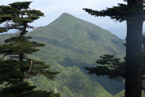
Benten no Mori sits at an elevation of 1600 meters, and a short descent on the far side of the rotund peak affords us our first views of Mt Misen and Mt Hakkyō, which sit high on a parallel ridge like a impenetrable feudal citadel. The route involves a direct ascent of Misen before swinging due south to the adjacent 1915m summit of Hakkyō, the highest point in the Kansai region. Luckily for us, we are in no rush and keep a slow yet steady pace, simply placing one foot in front of the other while relishing in the incredible beauty surrounding us.

After dropping to a narrow col, our rocky path continues along the ridge past towering beech, oak and hemlock trees casting a patchwork of brilliant shadows on the moss-covered floor. The piercing sound of a conch shell at close range startles us, and a glance up ahead reveals the Shungendō practitioner in full white garb directly in front of us. He belts out a few more sonic notes from his horagai shell while we look on with intrigue.

A short climb later we pay homage to En no Gyōja by bowing silently in front of the bronze statue overlooking the ruins of the Shōbō no Shuku resthouse that once stood here centuries earlier. Currently it is just a flat spot that would serve a tent adequately if the need arises. This is the start of the long slog up Misen’s formidable headwall, as the pitch steepens through long switchbacks along a carpet of verdant ferns. My last two autumn trips to this mountain never revealed the lush foliage that the warmer seasons afford, so I take in the sights and smells as a lucky observer. Clouds drift by overhead as Misen struggles to ward off the encroaching fog.

Through a gap in the foliage we catch glimpses of both Daifugen and Ōdaigahara sitting comfortably free of cloud as our route now enters a long promenade of wooden steps built directly into the hillside. I take a deep breath and place my first footfall on the weather-beaten timber and focus on my breathing while telling myself that every step forward is one step closer to our goal.

At the top of the spur, a clearing on our left beckons us over. We drop the packs for one final recess before the final push to Misen’s nearly 1900-meter plateau. The encroaching cloud brings a refreshing chill to the air as we shake our shirts to remove excess sweat accumulating on the wicking polyester fibers. Our pace slows considerably, mostly due to the return of those dreaded wooden steps: while they do provide assistance in gaining altitude, they do so at the expense of energy reserves for which we are desperately running low.

The watch reads preciously 4:30pm as we deposit our gear at a picnic bench beside the hut and rest our throbbing legs. This has been the toughest ascent of Misen thus far, and I mostly attribute that to the heat and our overstuffed packs. I head over to the hut to register, pay the modest fee, and purchase enough drinking water to sustain us for the evening. The campsite lies in a glen just out of earshot of the hut and we soon find a flat place to pitch the tarp next to a jovial solo elderly hiker. The sun plays a cat and mouse game as we finally inflate our air mattresses for a quick test of our barebones set up. Even though I have brought along a mosquito net, the chilly temperatures and altitude are enough to keep the blood suckers at bay, so we opt for a more open bedroom.
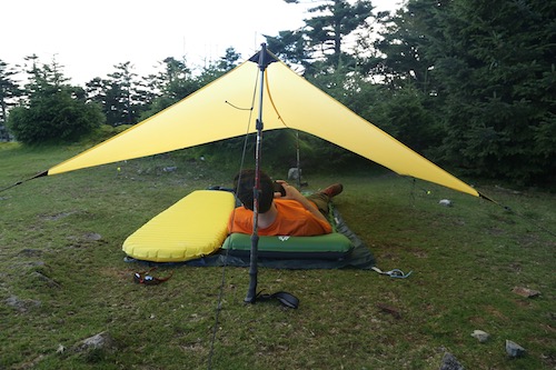
A lookout point just east of our campsite draws us, as our elderly camp neighbor recommends the unobstructed views across a steep valley toward the Ōdaigahara plateau. Paul M. and I sit at the top of the cliff face and take in the spellbinding vistas which do their best to restore vigor to our weary minds. The clouds continue to dazzle in their struggle to gain dominance over the sinking sun. We retreat to the picnic table to go over our dinner plans. “Should we cook now,” asks Paul, “or head to the summit for sunset?”. The decision is easy.

Mt Hakkyō sits as a neighborly peak, with a broad col separating it from Misen. Most Hyakumeizan climbers simply leave their packs at Misen for an up-and-back ascent of the mountain, which usually takes an hour roundtrip. Since it is my third time up to the peak and I am no longer checking off a list of mountains, I climb with no sense of urgency other than to make it to the summit before dusk.

Dropping to the col, we pass through the gates erected to keep foraging deer away from the Siebold’s magnolia groves and slowly pull our way up to the top. The summit itself is free of cloud, but a drifting fog bank blots off most of the views as the sun struggles to take hold. We wait patiently and can feel a turn of the momentum.

Suddenly, like the rising of a curtain, the clouds drop, revealing the Kinki Peninsula in all her splendor.

We take turns snapping summit photos and at one point while standing on a pile of stacked boulders, my shoelaces become intertwined and I trip while trying to stabilize myself—in my attempt to help cushion the fall I let go of my camera just in time before falling chest-first off of the meter-high cairn. My ribs are the first to take the impact, but luckily there aren’t any major puncture wounds to speak of. Regardless, each breath sends throbbing pain through the left side of my rib cage.

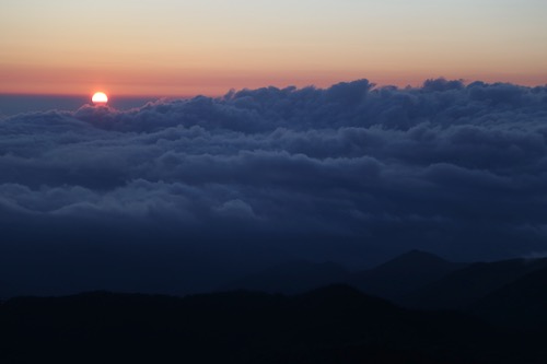
I try not to panic while switching to a shallower breathing rhythm to help ease the discomfort. The setting sun takes my mind off of the pain as we both stare in awe as the sun reaches the horizon. We are the very last people to witness the sinking of the sun from our rooftop perch on Kansai’s highest point. Never in my life have I laid witness to such mesmerizing light displays. Pink hues of alpenglow replace the grey horizon on the east as I put the pain aside and simply let my true excitement show.

We depart the summit at 6:45pm and retrace our steps by headlamp, arriving back at the picnic table after most of the other hikers have already gone to bed. We cook dinner and proceed to devour all of the curry we had brought for our meal. We followed that up with nuts and cookies we were planning to save for tomorrow.

Post-dinner we stow away our dinner gear under the tarp, turn off our headlamps and gaze upward at a dazzling celestial light show. The moon has yet to rise, giving us a clear view of what must surely be the best place for stargazing in the entire Kansai region.

Bedtime eventually beckons, but neither of us are really looking forward to the fitful rest. In my younger days I could sleep anywhere and anytime, but I’ve become such a light sleeper recently that I tend to wake up at even the slightest of sound. In the outdoors, it often means laying awake with my eyes closed for most of the night while struggling to fall into a deep slumber. Paul M. also struggles with the same issue, so camping adventures together often result in next-day grogginess.

I wriggle out of my sleeping bag shortly before 5am and scan the horizon to the east, which has already started to glow. I signal over to my partner, who is already awake and eager for coffee. We grab the breakfast kit and head to the lookout point to usher in the new day. The hot water boils just as the sun pierces the horizon and we welcome the warmth, for it has been a chilly night of temperatures hovering around 12 degrees.
Ōdaigahara sits in a thick cloud bank but it is a cloud-free morning that greets us up on Misen. After breakfast we leave camp and head back up to Hakkyō to take in the brilliant sunshine.

Instead of heading back to Misen, we continue on the Okugake Michi southwest to the adjacent peak of 1894m Myōjō or Mt Venus. The path follows the undulating ridge until reaching a junction for a loop trail that will take us back to Misen. The true summit of Myōjō lies just off the main path, so we follow a faint trail to the summit to take in the outstanding view of Mt Shaka.

We retreat back to the junction and leave the Okugake in favor of the loop. Thick groves of Veitch’s silver fir and spruce dominate these highlands, reminding me of parts of the Yatsugatake mountains. We meander among the hardwoods for an hour before taking a shortcut path to Ōkamidaira (狼平), which involves a direct descent on the treacherous eastern slopes of Mt Hinoura. We somehow manage to avoid falling to our deaths and celebrate by washing our faces in the cool soothing headwaters of the Misen river.

Crossing this stream leads us to the emergency hut at Ōkamidaira and a well-deserved bar of chocolate. From here is it an agonizing climb up a series of log steps to a false summit before a short descent and even longer traverse back up to Misen. The only upside to the slog are the pleasant vistas of the knuckle-shaped Mt Chōsen directly behind.
By the time we return to camp is it already 9:30 in the morning and we are already beat. Paul M. and I hastily break down camp and eat the remainder of our rations before retracing our steps back to the car, which we reach shortly before 12:30pm. It has been a hectic 24-hour trip, and apart from some bruised ribs, it has been a success. With such perfect weather this time around, I would surely be foolish to return a fourth time, or would it?

Posted in Kansai hikes | Tagged hikinginjapan, Kansai, Mt Hakkyo, Omine | Leave a Comment »
Shortly after finishing part 5, the rainy season kicked off unusually early, tapering off in early July before making a mysterious encore that lasted most of August. With the September heat beginning to dissipate, Ted and I hatch up a plan for the next section of the Takashima and spy a fair weather window at the end of the month. Once again, I board the first train to Kyoto and Ted navigates the car back to Ishidagawa dam which, due to a bizarre countermeasure against COVID-19, is currently closed to vehicles. We park on the shoulder of the road just below the dam and don our daypacks just before 8:30 as the sun still sits relatively low on the horizon.
Our route requires us to step over the chain-link barrier set up to keep vehicles from traveling along the battered road, and just a few minutes walk north brings us to the trailhead on our left through Wasatani (ワサ谷), looking a bit more overgrown and moist since our descent in May. I’ve got the gaiters strapped snugly around my shoes, and several steps along the route I spy my first mountain leech attempting to abseil up my leg. I sprinkle some salt as it jumps off my gaiter in fright and we pick up the pace until once again entering the cedar forest of switchbacks up the steep spur. A small brown Japanese tree frog sits camouflaged among the fallen tree needles and my footfalls send it hopping away to safety. No creatures and going to stop these men from reaching their hallowed ridge.
We make good work of the spur and rejoin the Takashima just before 9:30am and sit on a rotten log for a well-deserved break. I take off my gaiters, shoes and socks for leech inspection but am relieved to find that none have tagged along for the free meal. I spread the paper map out between us and study both the paper contours and compare them to the humpback ridge separating us from the summit of Mt Sanjo, our first major objective of the day.
I take the lead through a tunnel of beech trees contorted by the fierce winter gales that push in from the Sea of Japan. The accompanying precipitation can deposit well over a meter of snow, cutting off sinter access for most but the most experienced mountaineers. Through a gap in the trees, Ted and I can make out the grass-smothered slopes of Sanjūsangen, a perennial favorite from the hallowed Kinki/Kansai Hyakumeizan. The verdant slopes have already taken on that golden hue of autumn, as a brisk wind pushing in from the north reminds us that the first snows of the year are not too far on the horizon.
Fields of purple Kitatamabuji (monkshood) flowers reveal themselves as our beech tunnel gives way to open grasslands fit for a bear encounter. Ted and I are thankful for the westerly winds pushing our scent away from the fields and off the ridge into Shiga Prefecture, for the ursine creatures would surely find the sight of two humans trespassing in their backyard intriguing. I reach for the bear spray attached to my right hip, rehearsing the moves in case a sudden discharge is needed. Ted warns me not to spray upwind, as the bear would surely enjoy the sight of a scrawny hiker writhing in pain from having pepper-sprayed himself.
We enter an impressive strand of towering beech trees that give way to a clearing affording vistas of the summit plateau towering directly in front of us. It is at this sight that Ted and I congratulate ourselves for cutting stage 5 of our section hike short, for this is no place to be loitering at dusk. An occasional strand of yellow Takashima Trail tape reminds us that we are still on trail—though on the broad ridge it is really just a matter of following the natural ebbs and flows on the seldom used track.
After 20 minutes, green signage points us in the direction of Sanjo (三重嶽) as the route leads us up and over a series of small rises. The twisted trunks of beech trees mesmerize us by their artistic forms, with one such hardwood doing its best imitation of a sink drain pipe. How such forests can survive despite the odds in this fierce environment is a testament to the power and perseverance of living things.
The ridge narrows briefly before opening up again to reach a battered wooden signpost that informs us that the summit is just a 20-minute stroll away. We continue to navigate under the receding beech canopy and through the overgrown grasslands punctuated with groves of purple monkshood. At a gap in the trees I pause and turn around, awestruck by the unobstructed vista to the south, which reveals the folds of ridges of our entire section hike so far. I shout over to Ted through the wind, ushering him over so we can take in the sight together.
At the top of the next rise the angle abates, escorting us past a small pond and through yet more fields of wild grasses and ferns. It it truly hard to believe that we are still in Japan and we both feel as if we are setting foot on hallowed ground, walking through pristine forests in the footsteps of fallen samurai and mountains ascetics.
The final stroll to the summit of Mt Sanjo (10) seems to take forever, thanks in large part to my pausing every half a meter to snap a photo, for every footstep reveals ever-fascinating scenery. I don’t know if I will ever get the chance to revisit this place, so I want the memory to last. Just before the true summit, a handmade signpost pointing south informs us that Buna-ga-take is 5.1km away, and what a stunning five kilometers it has been. At the summit we rest in the shade and share a bite of Lara while a Japanese hornet does a flyby. The signpost has seen better days, having fallen victim to a foraging bear who has stripped the log post of most of its wood. We have also reached a milestone, with only 9 more stage points between here and the end of the trail.
We take a leisurely fifteen-minute break on top, enjoying the views and filling our tummies with calories that should sustain us until the summit of Mt Ōmikage, our next target on the ridge. At exactly 11:20 we once again hit the trail northbound, darting through giant trunks of beech while catching a glimpse of our next peak through a gap in the treeline. Ōmikage lies on a perpendicular ridge and it is topped with a rather large microwave antenna, making recognition easier. We need to continue to the north until we reach this east-west ridge, where we will change directions and embark on a rather elongated climb, judging by our current visual sighting at least.
The beech groves yield to a sprawling savannah-esque plain that could easily be mistaken for the Serengeti. We expect a herd of Wildebeest to rush through at any moment. Powered on by the late morning nourishment, I take off in a trot in order to gain a little distance between Ted and I, as a figure does helps provide a sense of scale to the images captured through my lens. I can’t help bursting into a heartfelt rendition of Toto’s Africa.
This is easily the best scenery of the entire Takashima so far, and we are both thankful for the stable high-pressure system providing us with pleasant skies.
Over a series of open ridges we trod, pushing ever closer to our next peak. We catch glimpses of Mt Aoba and other peaks of northern Kyoto Prefecture to our left, while on our right we gaze at the foreshortened ridges of eastern Shiga Prefecture. The rugged shoreline is also visible due north where the cobalt sea meets the unspoiled shores of Fukui Prefecture. We are truly in a magical corner of the Kansai region and can do nothing to hide our elation.
We pause briefly on the summit of Peak 943, the scene of a bear attack back in 2015. The poor hiker was southbound and had just spent most of the day hiking when he suddenly encountered a bear at close range in dense fog. An account in Japanese can be found here and it is the main reason why I decided to carry the bear spray. We scan the horizon but no creatures big nor small can be found.
Several more hills are traversed before we pass by a small pond and yet more groves of virgin beech. As we edge closer to the parallel ridge, the forest finally transitions to a mix of oak and cedar trees briefly just before the summit of Peak 889 before we duck once again into the sprawling city of beech. The shadows cast by the early afternoon sunlight provide an artistic blanket on the forest floor.
Finally, at 12:30pm, we meet the east-west ridge, where the Takashima takes a hard right turn and enters an ancient route known as the Ōmizaka Kodo (近江坂古道). The ridge line that we are now beginning to walk was once the main walking route between the ancient provinces of Ōmi and Wakasa and we are pleased to find not only the trail well-marked, but also the gentle gradient easy on the feet. Rather than taking a lunch break here, we decide to push on to Ōmikage.
The route is pretty straightforward at first until transitioning to switchbacks on the long approach to the summit. Ted starts to fall behind a bit, making us regret postponing lunch, so I slow up a bit to give him a chance to stay within earshot. I feel surprisingly good despite the distance we have traveled so far. It takes us an hour to reach the microwave antenna on the summit of Ōmikage (9), but we are relieved to find the true triangulation point a bit further along the ridge on a more pristine knob. I drop the pack and rest in the shade, and Ted makes his way up to the summit a few minutes later, where it is time for a proper lunch. Both of us are ravished and glad to make our packs lighter.
The half-hour break helps restore our depleted energy reserves, which we will surely need for the long journey back to the car. During our sandwich break, we once again pore over the paper map and agree that traversing over to Nukedo pass will allow us our best chance of perhaps catching a ride back to our car, for the pass is the junction of a trio of forest roads covering from both Shiga and Fukui Prefectures.
Shortly before 2pm the packs are once again strapped to our shoulders and we continue east towards the pass. By now the sun is starting to sink lower toward the horizon, lending softer shadows and providing excellent photographic lighting through yet another phenomenally beautiful section of trail. We have yet to meet a single other hiker on our entire route, a testament to just how remote and inaccessible the hidden folds of the Takashima truly are. At the top of a long rise, a shortcut trail to our right cuts down to the forest road, but we decide to push on to Nukedo by all means necessary.
Once past this rise, the trail begins to drop, gently at first, towards our elusive pass. The closer we get, the more abrupt the descent until we finally reach a trickling stream and pop out onto the roads at Nukedo (8-1). A paved road on our left leads down into Fukui Prefecture. I walk a short distance to a parking lot but am gutted to find no cars—our chance for a free ride is gone. On the Shiga side, the forest road back to our car is barricaded by a locked gate and looks as if no vehicles have been up here for at least a decade. I sit on a concrete wall to give my legs a brief rest as we think. Our original plan was to continue east to Mt Ōtani and a long escape route down towards Makino, where we could hail a taxi back to our car, but there would be no way to make it down before dark. Plus, the prospect of another ascent on weary legs is too much to bear. There is only one other alternative.
Ted and I look at each other and nod wordlessly as we climb over the barricade and onto the gravel forest road. It is preciously 3pm when we start the long slog back to the car. At least all we need to do is to follow a road back, but we are both shocked to find the road climbing. And climbing. And climbing back towards the long rise we had traversed on the way down from Ōmikage. Morale is at a new low as we walk in silence, leg muscles burning, past research cameras placed to keep tabs on the local ursine population. After a grueling 40 minutes we pass by the shortcut trailhead leading up to the ridge and the road finally begins its descent toward the valley far below. Ted double checks our location on his phone GPS and lets out a gasp as he inadvertently looks at the amount of horizontal distance left to cover. “Please don’t tell me how many more kilometers we have left”, I shout, knowing that it will only lower our sinking morale. Silently, I guess that we have about 15km to walk on the road, but we manage to avoid talking about this for the remainder of our walk. We do engage in small talk while trying our best to simply put one foot in front of the other. We are in a race against the setting sun but it is important not to rush when you have such a formidable distance to cover.
The road drops to meet a stream and after 40 minutes we reach an alternative trailhead to Mt Sanjo. This is the route we were originally planning to descend on day 5 before opting for the escape route that we had used for our approach to start our day. We break here for about 10 minutes, sitting next to the trailhead and stretching our legs for one final snack to help sustain us for the remainder of the walk.
We continue to traverse through bear territory, half expecting to come across one at every bend in the road. Somehow, the creatures continue to elude us as we make good progress on the long gravel thoroughfare. Further downstream we pass through a locked gate that looks remarkably similar to the once erected at Nukedo. Perhaps we are once again in an area where vehicular traffic is allowed.
30 minutes later we reach the end of the road, where it deposits us on a paved road that connects Ishidagawa dam to Hakodateyama ski resort. I recognize this road, as we walk past the place where we parked during my first ascent of Mt Sanjo back in 2015. This road has fallen into ruin during the last several years and now no vehicular traffic is allowed until repairs are made. The pavement looks to be in pretty descent condition until we reach a massive landslide just 10 minutes further long the road. After scrambling up and over this obstacle we continue past several other washed out sections of bitumen in the fading light of the day. We reach the car at 6:30pm in near total darkness. We have walked over 30km on this mammoth 10-hour day, but with vehicular access to Nukedo on the Fukui side of the mountain, we now have a clear path to finishing the Takashima trail, which will take just two more days according to our newly hatched plan. The hard part is over, or so we think.

Part 7
Posted in Takashima trail | Tagged Hiking in Japan, Kansai, Mt Sanjo, Takashima trail | Leave a Comment »
Early May and the middle of the Golden Week holiday brings Ted and I together for another rendezvous with the Takashima Trail. The next couple of sections of the trail are going to require both an immense amount of planning and an even greater exertion of energy—two of our fortes. This is our furthest drive yet, as we finally navigate the entire length of route 367 right past today’s starting point of Sakura-tōge and under route 303 to our final destination at Ishidagawa dam. We park at the dam, prepare our gear and hit the asphalt in high spirits, for we need to walk all the way back to where we last left the Takashima on route 367—or do we?
The snaking curves of the road down from the dam lead us along an idyllic section of road following the Ishida river downstream past a bustling campground. Groves of parasitic wisteria flowers flutter in the gentle breeze under the soothing sunshine of early summer. We enter a hamlet with residents busy tending to fallow fields. A flattened rat snake lays victim to an early morning vehicle. “Looks like they’ve woken up,” exclaims my companion, apprehensive of an encounter with a living reptilian foe up on the ridge.
We stroll down the road and meet route 303. The lane we drove in on cruises safely under the national highway but instinct sends us up an incline to meet the busier road. “We should be able to hitch a ride from here,” explains Ted, still riding high with confidence from our successful hitchhike during part 4 of our adventure. Sure enough, the third car to pass screeches to a halt while Ted and I scurry to put on our face masks. Just minutes later we thank our driver, shoulder the packs and enter the forest at Sakura-tōge (14). Among a grove of cedar trees nature calls, so I dig a hole and go about my business while Ted checks the GPS.
Leaving the comfort of the valley floor, Ted and I commence our ascent up a steep spur adorned with the fresh foliage of the summer canopy returning to the mountains. The sunshine sparkles off of the leaves as we push on through groves of Japanese andromeda and rhododendron buds on the verge of blossoming. Beech and oak trees guide us upward along the narrowing spur as we catch our first vistas across the valley to the Hira behemoths of Buna-ga-take and Jyatani-ga-mine. I turn to Ted and he nods at me as we stare in silence and reflect upon our winter accident on what appears to be gentle slopes from this vantage point.
After half an hour the track reaches the crest of the ridge for a roller coaster of a walk alternating between monolithic strands of planted cedar and free-wheeling colonies of beech and oak. Through one section of the former, our trail meanders around a section of typhoon debris, but those ubiquitous strands of yellow Takashima tape liberally tied to an occasional cedar usher us safely through the mess and onto a long steady slope to the summit of Mt Ni-no-tani (13). True to its name, there are two summits on the plateau, so we break for a snack on the first peak before heading over to its twin and slightly higher of the two, home to an tranquil tarn.
Though a gap in the trees, a formidable wall of green towers over us directly north. It is Buna-ga-take, our target for the afternoon and not to be confused with the other Buna-ga-take sitting directly behind us to the south. Cause for celebration is unwarranted, as the map shows us we still have over 5km of hard hiking to reach its striking summit plateau.
The loss of altitude is almost immediate after setting foot down the northeastern face and we grasp onto tree limbs to help fight against the downward pull of gravity until the angle eases abruptly and passes by a section of golden grass that looks fit for a bear encounter. The ridge narrows briefly and we meet our first hikers of the day. The first guy is wearing trail running gear and is equipped with nothing more than a 2-liter bottle of water grasped in his right hand as he passes head on in silence and makes quick work of the steep slopes we have just come down. There have been reports of ultra trail enthusiasts doing the entire 80km section in one day but I think I prefer our more leisurely pace.
After a brief climb past an unnamed peak the trail once again loses altitude suddently and guides us through a section of lush ferns to reach the paved road at Misaka-tōge (12). It is hard to believe that we have only a dozen more checkpoints until finishing the trail, but it is still going to take a few days to get there. We sit on a log and break for an early lunch in the shade in the forest of the 280-meter high pass. This is the old road before the tunnel was built through the mountain and if we turn left here and walk for an hour we could reach Kumagawa-juku on the old Saba Kaidō, but tourist post towns are not what bring us to the Shiga-Fukui prefectural border. We have a mountain to climb.
Again we play a cat-and-mouse game of cedar forest and hardwood grove as we face the longest and hardest climb on the entire Takashima Trail. As on past sections of the Takashima, the conversation turns to writing and working with copy editors, as Ted is on assignment to finish his contribution for a new guidebook with a constricting word count. It is always the nemesis of any travel writer and part of the reason I prefer the freeform nature of blogs. Our banter takes our mind off of the task at hand until the ever-steepening slope angle forces us into silence: we search for those inner reserves necessary to see us though to our goal.
Our initial target is to make it to the western peak of Mt Akaiwa without stopping but shortly before the summit we collapse in a heap of sweat and exhaustion. We need Lara again, and Ted delivers the goods. I pass along some chocolate and other nibbles as we rehydrate and stretch our legs. It turns out our decision is a wise one, as once we get back on our feet the path further steepens to enter a rock outcrop adorned with fixed ropes.
We hoist ourselves up and onto an outcrop affording spectacular vistas back over to Mt Ni-no-tani and over to route 367 where we had started our morning. Boy have we come a long way.
The foliage begins to take on an early spring hue as we breach the 700 meter mark and walk past a junction on the western summit Mt Akaiwa. Dense groves of rhododendron and andromeda shrubs line our way as the track narrows. Dollops of the pink iwakagami (fringed galax) once again line the trail. We have entered an entirely different ecosystem up here, on the edges of snow country and evidence of the harsh winters that batter these mountains is apparent. It is as if the retreating snow fields had melted just days prior as tree buds begin to sprout and put on their summer coats.
Kobus magnolia flowers flutter in the light breeze. It’s hard to believe that these same trees bloomed one month earlier at around the same altitude further south along the Takashima. As we admire the views, a solo female hiker approaches from the summit plateau and passes by. She is on her way down to Misaka-tōge and it dawns on us why the majority of hikers do the Takashima Trail from north to south in order to avoid our herculean climb of Buna.
We skirt past a small pond and onto the summit of Buna-ga-take (11). Time check: 1:38pm. It has been nearly 5 hours since we left our car at the dam but we have arrived. The undulating ridge between our vantage point and our next summit of Sanjo looks formidable. A change of plan may be necessary.
With an impressive view of snow-capped Hakusan on the horizon, Ted and I straddle the ridge with the paper map spread out between us and start calculating. If we push on to Sanjo it will be after 4pm, and a two-hour descent on rubbery legs on a long spur means that it will be well after dark when we reach the car. However, just a kilometer from Buna’s summit, on the ridge we need to walk, is an escape route down a spur that will take us directly to our car. The choice is easy.
Fueled on by the prospects of a shorter day, we dart along the ridge and duck into a truly scenic section of gnarled beech trees sculpted by the strong winds and snow that batter the ridge every winter. It feels like we have stepped into an enchanted forest and fortunately for us, we are blessed with brilliant sunshine and not the mind-altering hallucinations brought on by thick fog and tired minds.
Unsure of our escape route, Ted and I keep a close eye on the GPS but we are relieved to find a signpost in Japanese for Wasatani (ワサ谷) letting us know that we have 3.8km to go before reaching the road to the dam. I lead the way in high spirits before jumping in surprise after nearly stepping on a giant rat snake. Ted is thankful that I am the one encountering all of the slithering creatures for him, as he has a fear of the serpents.
Our majestic hardwood forest soon turns into a monocultural cedar plantation, but fortunately the descent is negotiable along a series of long switchbacks that usher us down to a gravel forest road covered mostly in fresh grass. This leads to a stream smothered in concrete dams and the eventual paved forest road above the dam. We turn right and stroll along the closed road for 10 minutes to reach the car at 3:30pm. The drive back to Kyoto is spent strategizing about how to walk the next section of the Takashima as it is easily the most remote part and will take some thinking.
With the approach of the rainy season, we both agree to take a few months off to scour trip reports and rack our brains for the best course of action.
Posted in Takashima trail | Tagged hiking, Hiking in Japan, Japan, Kansai, Takashima trail | Leave a Comment »
The weather of early April continues to remain stable, offering plenty of opportunities to knock off the next section of the Takashima Trail. If our plan comes to fruition, we can reach the halfway point of our journey and what better way to celebrate this milestone than by inviting along a few extra friends. Cue my faithful Nagoya-based hiking partners Hisao and Haru, who bring along ultra-trail hiker Paul from Hike and Bike Japan. Meanwhile, Kyoto resident Van heads up by bicycle while Ted drives our vehicle to the rendezvous point at Kutsuki Michi-no-eki. After an early-morning discussion of the plan and a quick stocking of rations at the Lawson convenience store, we board the community bus bound for the secluded village of Kijiyama. We have the minivan to ourselves for the 40-minute journey along an incredibly narrow road hugging the banks of the Asao river. We alight in the sleepy village and are immediately greeted by a duo of anatomically-correct stone kappa statues placed in the village in an apparent attempt to trick hikers into falling for their ruse.

We walk along the paved road northwest past a grove of rhododendron that have somehow managed to bloom unseasonably early in the biting air of late spring: perhaps those pesky statues have coaxed those flowers out of their shy buds, Meanwhile, a grove of plum blossoms further on remind us that summer is still quite a long ways off. High above, the greenery is only just starting to return to the mountains after a long, dormant winter. Our road transitions from asphalt to dirt and starts gaining altitude towards the ridge. We follow suit shortly before cross checking our position with the GPS and realize that we have gone off route. We backtrack to where the incline starts and enter a narrow watershed lined with tape marks affixed to a series of hardwoods. I scan the forest floor for signs of mountain leeches but am relieved to find that the chilly temperatures have kept them at bay. In the early morning sunshine we follow the moss-covered stones toward the ridge and our impending return to the Takashima.

The trail keeps to the left bank of the river for the most part, but, like most gorge trails in Japan, ascends high above the river bank past a series of waterfalls before meeting up with the river’s edge further upstream. We exercise care in this section, walking single file while double checking our footholds. One slip here would be an early end to our day.

Haru takes the lead, escorting us past a depilated shelter once used by forestry workers before ushering us across an improvised wooden bridge consisting of cedar logs fastened together with thin wooden planks. The logs bend and bow under our weight but somehow they hold long enough to allow safe passage for everyone. About 50 meters upstream, we cross the river once more among the idyllic waters of the tranquil stream. It is refreshing to find these watersheds untouched by the hands of the concrete industry.

I stay near the rear, making sure everyone keeps pace among our sexy sextet of experienced hikers. Suddenly, I hear shouts from Haru ahead and rush to catch a glimpse of a rather large and bushy brown animal running up the adjacent hillside. Haru and Paul claim that it is a tanuki (a raccoon dog) but without a closer look at the markings I have no way of knowing exactly for sure. From my vantage point it could certainly have been one, but I wouldn’t be surprised if it were an anaguma, a Japanese mountain badger. Unfortunately the creature skitters off too quickly for anyone to gather photographic evidence.
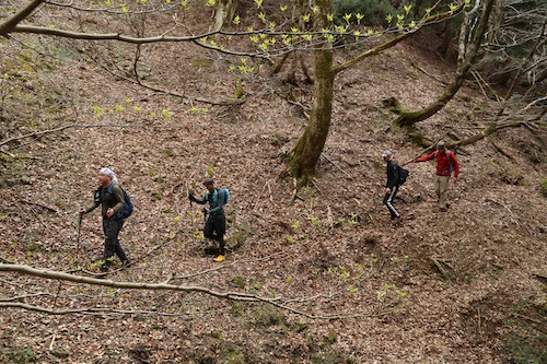
At this next section we struggle briefly to find the tape marks, as they leave the river bed and skirt up the right bank of the river up a steep spur that leads much further upstream towards the headwaters of the Asao river. We walk past a rusted pulley system left behind by some inconsiderate loggers before we ascend a rugged incline to traverse high above the river along a flat trail adorned with fixed ropes. As we walk straight ahead, the river below rises up to meet us and from here to the ridge it is simply a series of negotiable switchbacks.

We reach Kijiyama-tōge (21) at 9:15, just one hour after leaving the forest road. It’s hard to believe I was standing on this exact location exactly 10 days prior. We catch our first glimpses of Mt Aoba between the bare branches of the hardwoods, while the brilliant white petals of the Magnolia kobus glisten in the morning light. A track here drops to the north into Fukui Prefecture, perhaps another route for porters in the olden days to use for delivering fresh fish to the landlocked villages in Kyoto. I explain to Paul and Hisao that a left turn here will lead them to the panoramic views from the summit of Mt Hyakuri-ga-take. Being seasoned trail runners and fast packers, they rise to the challenge, and we all agree to meet up further long the ridge as they will surely soon catch back up with us.

Ted, Hisao, Van and I head northeast along the Takashima up the first slopes of hearty beech trees. Ted and I explain a little about the terrain that we have experienced along the route up this far as they listen eagerly for a teaser of what is to come. It takes us about 20 minutes of steep climbing to top out on Mt Sakuradani (20), the first of several peaks planned for the day. The vistas down to Kijiyama village and beyond stop us in our tracks, as we settle in for a mid-morning snack. I shout across the valley toward Mt Hyakuri, hoping that Paul and Haru will return our greeting, but the distance is too great for our calls to reach them.
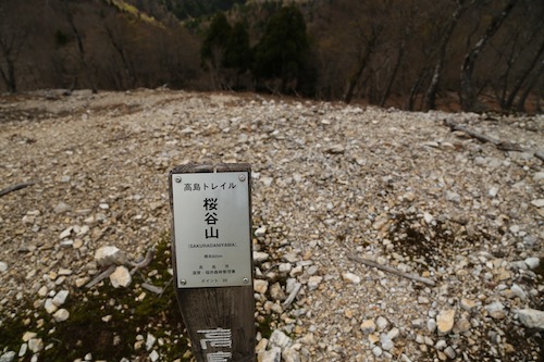
The lime green hues of the foliage beginning to return to the trees brings a sigh of relief that the dull tones of winter will soon be in the rear view. From the summit we head due east, along a bare section of stony ground that affords incredible views of the remainder of the Takashima trail. Directly ahead, the rotund hump of Komagatake stands tall, while further beyond we can trace the foreshortened ridges in the direction of Norikura, our final goal of the section hike. With a bit of luck we can reach it in just four more days, depending on how much of this ridge we can knock out today.

Onward we stroll, transfixed on not only the splendid beauty of the dense deciduous forest but also the jovial conversation about trails, travel, and outdoor gear. It is in these moments of trance-like movements that you really get to know a person, and in our quartet we not only share our experiences but also find time to become absorbed in our own thoughts and observations. To our left, the coastal areas of northern Fukui Prefecture grace us with our presence as if to remind us that we are indeed walking on the central divide. Meanwhile, Lake Biwa beckons us for a peek on our right as the contorted figures of the towering beech trees offer a welcome distraction from our gazing: stare too long out to the horizon and you will certain miss the sheer beauty that can be found right underneath your nose.
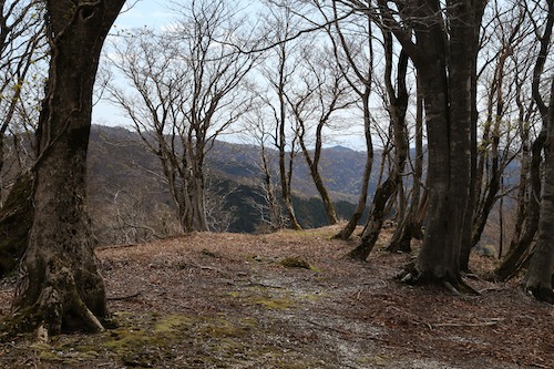
We traverse along a narrow section of ridge affording vistas back down to our starting point at Kijiyama. Towering over the village, like a protective watchtower, soars the humpback shape of Hyakuri whose southern face still clings tightly to one remaining snowfield. Here we run into our first hikers of the day, a middle-aged duo heading towards our starting point. After an exchange of pleasantries, the four of us continuing our forward march towards the folds of ridge directly ahead to Komagatake.

At the top of the next rise a hand-painted signpost informs us that we have arrived at peak 765, a common designation for peaks that have no name. The dried grasses provide a soft cushion on our feet as we gently descend to an old pass named Ikenokōchigoe. Apparently in the old days a track dropped off the ridge here to the north to Ikenokōchi village and further along to Obama. It certainly made more sense in the pre-automobile days to take the direct route over the mountains than to detour hundreds of kilometers around them.

The undulating ridge continues on, and the top of the next rise through a grove of towering beech takes up to Yosukedaniyama (与助谷山) (19) and a dilapidated signpost proclaiming that Komagatake is just 2.4km away. While we examine the maps a shout from behind announces the arrival of Paul, who has just spent the last hour running the ridge between Hyakuri and here. As we catch up on our prospective trail stories, Haru also rejoins us as our sextet is now reunited for the final push to the summit. And with such pleasant company comes a truly stunning section of curvy beech trees beckoning us forward.

A dirt forest road runs just below the true ridge for our next little section as our route takes a turn to the north. It is here that Ted and Hisao find out they are both fans of Soul Flower Union and spend the next half an hour engaged in a truly passionate exchange about music. We soon reach the junction for the western ridge course, the escape route that William and I took on our first visit to the peak. I am now back in familiar territory for the next 3.5km and spent most of the final climb to Komagatake telling stories of our battle with Asian giant Hornets during our first visit.

A couple of other hikers are lounging in the sun when we arrive at 780 meter-tall Komagatake (18) a little before 11:30am. We settle in for a well-deserved lunch while taking in the views across Lake Biwa to Mt Ibuki. Ted lounges in the trunk of a sprawling beech tree flanking the northern edge of the broad summit. We share a few snacks between us as we once again stare at the paper map in utter disbelief in how much more ground we have to cover. It is going to be a long afternoon.

We ask one of the other hikers to snap our photo so we can actually have a picture of all six of us together, before we once again shoulder the packs and hit the trail with an added pep in our step. A signpost indicates that our mountain is officially called Wakasa-komagatake to help differentiate it from the dozen or so other Koma peaks scattered throughout Japan. Shortly past this marker I lead the way down a series of log steps that I don’t recall during my first visit to the area. We pause and double check the GPS to realize we have inadvertently taken a spur trail on an adjacent ridge that eventually leads to Kumagaya Juku on the old Saba Kaidō. We backtrack and turn left for the correct track that leads due south over Komagoe (17) and through a series of Magnolia kobus flowers in their brilliant shade of shiny white.

The ridge continues to ebb and flow as we pass right by the gigantic beech tree that was smothered in giant hornets during my first visit. I for one am happy that the brisk early-April air has not only kept the bees away, but has also foiled any plans for the mountain leeches and snakes to awaken early from their winter slumber. During this next section of track I keep hyping up the brilliant waters of Koma-ga-ike but have set myself up for disappointment as the pond is but a tiny fraction of its mid-summer self. Still, the tranquil waters are worthy of a snapshot or two before we continue our march along the long, long ridge.
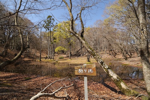
After passing by the junction for Mt Ikehara (my entry point during my first climb) I am once again in unfamiliar territory. Rather than cruising along the ridge, we find ourselves on a rather abrupt climb up a steep hill as Paul and Haru set off ahead as if on a training mission. The four of us march behind, a series of profanities erupting from my mouth as my legs are not ready for the sudden call of duty. On the summit of the unnamed and unmarked peak we find both Paul and Haru catching their breaths so we let out a sigh of relief that they find the climb just as tough as us.

Our route flattens out for a bit before a gentle descent turns into a sudden rope-grabbing plunge of altitude to Yokotanitōge (16) at an elevation of 450 meters. It has only taken us 90 minutes to reach this pass situated on a paved forest road—only the second paved road we have crossed since starting the Takashima. With one more major peak to climb today, we settle into a calm but steady rhythm through thick groves of rhododendron that are still a few months away from flowering. The waxy leaves are a refreshing site after the high canopy of soaring beech groves.

We soon find a signpost signifying that our final peak is just 1.7km away and the steady climb takes us just 45 minutes to reach Gyōjayama (15) among a shaded grove of cedar. “Cappuccino time,” I announce, as I toss a Koda energy gel over to Ted while the others look on with interest. Unfortunately I have not packed enough of the gels for everyone in our climbing party, but since Ted does have the car keys and is the one accompanying me on this Takashima journey, I know where my priorities lie. Paul occupies himself with trying to repair the broken summit signpost but soon declares it a lost cause, which is what we will all be if we don’t start making a move.

Ted and I, fueled on by the caffeine coursing through our veins, shoot out ahead of the others. We are expecting just a gentle descent to the main road, but our route sends us north over a series of rolling summits with plenty of elevation gain and loss between. This leads us to an undulating ridge of mixed conifer and beech, past a giant fir tree and under a massive electrical pylon before commencing one one final knee-knocking descent to reach a paved road. At last, with flat, easy ground to walk on, we coax to the finish line on route 367. Well sort of, for we still have 5km to walk on the busy road to reach our car at Kutsuki Michi-no-eki. However, I have hatched up a plan.
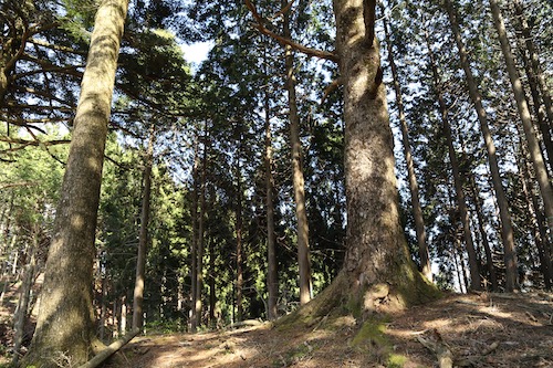
Once we reach route 367, Ted and I head further up the road toward the junction of Sakura-tōge (14). It’s kind of ironic that the actual Takashima Trail involves a short section of road walking before ducking back into the mountains, but all long-distance hiking trails in Japan require you to walk on a road at some point, as the country is too small and overdeveloped for large sections of wilderness to remain untouched. Anyway, Ted and I have no intention of walking 5km back to our car. We find a section of road with a broad shoulder and I fish the handmade cardboard signboard out of my backpack, a sign that I had made it the previous day in hopes of hitching a ride back to the car. It was time to put it to the test.

The first car swooshes by like we aren’t even there. The second car, however, comes to a halt about 50 meters in front of us as Ted and I trot up to find the driver ushering us toward the back seat of the minivan. We slip on the facemasks and head south on route 367 towards our car. Our ride soon catches up with our companions walking single file on the road. Ted rolls down his window and explain that he will retrieve his car and come pick everyone up. Paul catches word of this and decides to race Ted back to the Michi-no-eki. Our ride drops us off at Ted’s car and I head to Lawson for a cold drink while Ted speeds up the road to pick everyone up. I return to where Hisao’s car is parked and rest in the shade, rehydrating my body and stretching my tired legs. All of a sudden, I hear someone yelling “Wes” and look up to see Paul jogging the last few meters to Hisao’s car while Ted swerves the car into the parking lot. Paul has won the race against Ted’s racing automobile.

It is an unforgettable hike and a most fitting way to celebrate the 50% mark of the Takashima. With a little under 40km remaining, the light at the end of the tunnel is now in sight. Can we hike the next section before Golden Week?
Posted in Takashima trail | Tagged Fukui, hikinginjapan, Kansai, Shiga, Takashima trail | Leave a Comment »
